Arid Land Geography ›› 2023, Vol. 46 ›› Issue (1): 127-138.doi: 10.12118/j.issn.1000-6060.2022.241
• Regional Development • Previous Articles Next Articles
LUO Zhanfu( ),ZHANG Rong(),ZHAO Xueyan,LIANG Jingjing,WANG Jiaming
Received:2022-05-24
Revised:2022-08-05
Online:2023-01-25
Published:2023-02-21
LUO Zhanfu, ZHANG Rong, ZHAO Xueyan, LIANG Jingjing, WANG Jiaming. Evaluation and influencing factors of rural territorial space security in loess hilly region: A case of Lintao County[J].Arid Land Geography, 2023, 46(1): 127-138.

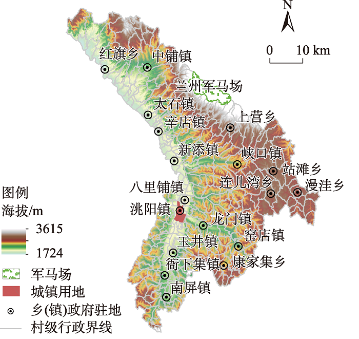
Fig. 1
Overview of the study area"
Tab. 1
Data types and sources"
| 数据类型 | 数据来源 | 数据说明 |
|---|---|---|
| 高程数据 | 地理空间数据云( | 栅格分辨率为30 m |
| 归一化植被指数 | 地理空间数据云( | 栅格分辨率为250 m |
| 土壤数据 | 临洮县自然资源局 | 2020年数据 |
| 中国土壤数据集(V1.1)( | 栅格分辨率为1000 m | |
| 地质灾害隐患数据 | 临洮县地质灾害防治规划 | 2020年数据 |
| 土地利用类型数据 | 中国科学院资源环境科学数据中心 ( | 2020年数据 |
| 降水 | 临洮县气象局 | 2020年数据 |
| 交通道路数据 | 国家基础地理信息中心( | 截至2020年6月的矢量数据 |
| 空间行政边界、河流矢量数据 | 中国科学院资源环境科学数据中心 ( | 2020年中国县级行政边界数据和中国三级流域空间分布数据 |
| 社会经济数据 | 临洮县乡村农业局统计年报(2020年)和各乡镇基层年报 临洮县人民政府网站( 《临洮县统计年鉴(2021年)》 | 2020年和2021年数据 |
Tab. 2
Evaluation and classification of rural territorial space security in loess hilly region"
| 等级 | 国土空间安全分级 | 乡村国土空间安全评价指数(R1)取值范围 | 表现特征 |
|---|---|---|---|
| 1 | 高安全 | R1>0.71 | 生产、生活及生态空间的要素质量好,功能强,要素间关系协调,面对外界影响干扰的系统韧性强,国土空间安全有序稳定。 |
| 2 | 较高安全 | 0.61<R1≤0.71 | 生产、生活及生态空间的要素质量较好,功能较强,要素间关系较协调,面对外界影响干扰的系统韧性较强,国土空间安全较有序稳定。 |
| 3 | 中等安全 | 0.51<R1≤0.61 | 生产、生活及生态空间的要素质量一般,功能一般,要素间关系一般,面对外界影响干扰的系统不发生根本性变化,但遭受损伤的国土空间安全在内外部作用下可逐步恢复原来状态。 |
| 4 | 较低安全 | 0.41<R1≤0.51 | 生产、生活及生态空间的要素质量较低,功能较差,要素间协调性差,面对外界干扰干扰会使国土空间系统的基本结构、功能、关键特征以及反馈机制受到较大损伤,恢复原状难度大。 |
| 5 | 低安全 | R1≤0.41 | 生产、生活及生态空间的要素质量差,功能差,要素间冲突大,面对外界干扰会使国土空间系统的基本结构、功能、关键特征以及反馈机制严重受损,难以恢复原状。 |
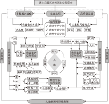
Fig. 2
Logical framework of rural territorial space security evaluation in loess hilly area"

Tab. 3
Evaluation index system of rural territorial space security in loess hilly region"
| 目标层 | 维度 (权重) | 准则层 (权重) | 指标层 (权重) | 指标 正负向 | 指标 类型 | 对应SDGs 指标 | 指标计算解释 |
|---|---|---|---|---|---|---|---|
| 乡村 国土 空间 安全 | 农业生产 空间安全 (0.363) | 耕地质量水平(0.094) | 土壤有机质含量/g·kg-1[ (0.253) | + | 常规化 | SDG1 SDG2 SDG15 | 耕地质量越高,支撑农业生产的安全水平越高 |
| 耕地坡度/(°)[ (0.196) | - | 常规化 | |||||
| 耕地连片度[ (0.259) | + | 常规化 | 耕地连片程度 | ||||
| 基本农田保护率/%[ (0.292) | + | 本地化 | 基本农田近3 a面积增减 | ||||
| 劳动力丰裕度(0.092) | 外出务工人员比例/% (1) | - | 本地化 | SDG8 | 乡村外出务工人员占乡村总人口比重 | ||
| 水利化程度 (0.112) | 灌溉保证率/% (1) | + | 本地化 | SDG12 | 农田灌溉有效灌溉面积占总耕地面积比重 | ||
| 气象灾情程度(0.065) | 农作物受灾面积比例/%[ (1) | - | 常规化 | SDG11 | 农作物受灾面积占总耕地面积比重 | ||
| 农民生活 空间安全 (0.341) | 住房安全水平(0.055) | 居民住房质量/m2 (1) | + | 本地化 | SDG11 | 乡村砖瓦房屋面积÷乡村房屋总面积 | |
| 出行便捷水平(0.067) | 路网密度/m2[ (1) | + | 常规化 | SDG9 | 乡村道路用地长度÷乡村占地面积 | ||
| 用水安全水平(0.081) | 距水源地距离/km (1) | - | 常规化 | SDG6 | 距水源地距离 | ||
| 人均日生活用水量/L (1) | + | 常规化 | 人均日生活用水量 | ||||
| 用能安全水平(0.075) | 乡村清洁能源利用率/% (1) | + | 本地化 | SDG7 | 乡村使用太阳能器(灶)、沼气用户占比 | ||
| 室外安全水平(0.034) | 人均避难场地面积/m2 (1) | + | 本地化 | SDG11 | 乡村健身广场占地面积 | ||
| 救治安全水平(0.029) | 乡村医疗卫生机构数/个 (0.521) | + | 常规化 | SDG6 | 乡村医疗卫生机构数 | ||
| 千人床位数/张 (0.479) | + | 常规化 | 千人床位数 | ||||
| 乡村生态 空间安全 (0.296) | 水源涵养能力(0.076) | 植被指数 (0.527) | + | 常规化 | SDG15 | 植被指数 | |
| 水域湿地指数/m2 (0.463) | + | 常规化 | 河流(渠)、湖泊(库)及滩涂湿地面积÷乡村占地面积 | ||||
| 水土保持能力(0.117) | 梯田面积占比/m2 (0.421) | + | 本地化 | SDG15 | 乡村梯田面积÷乡村耕地面积 | ||
| 草地面积占比/m2 (0.274) | + | 常规化 | 乡村草地面积÷乡村占地面积 | ||||
| 林地面积占比/m2 (0.305) | + | 常规化 | 乡村林地面积÷乡村占地面积 | ||||
| 生态修复需求 水平 (0.108) | 地质隐患点面积占比/% (0.529) | - | 本地化 | SDG13 | 地质隐患点面积÷乡村占地面积 | ||
| 矿产资源开采面积占比/%(0.471) | - | 本地化 | SDG13 | 矿产资源开采面积÷乡村占地面积 |
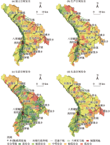
Fig. 3
Grade distribution of rural territorial space security evaluation in Lintao County"

Tab. 4
Grade structure of rural territorial space security in Lintao County"
| 安全等级 | 乡村数量占比/% | |||
|---|---|---|---|---|
| 乡村国土空间安全 | 农业生产空间安全 | 农民生活空间安全 | 乡村生态空间安全 | |
| 高安全 | 13.88 | 10.49 | 20.68 | 13.27 |
| 较高安全 | 23.76 | 19.14 | 40.74 | 26.54 |
| 中等安全 | 32.09 | 34.25 | 12.04 | 34.88 |
| 较低安全 | 22.46 | 26.46 | 19.13 | 19.08 |
| 低安全 | 7.81 | 9.66 | 7.41 | 6.23 |
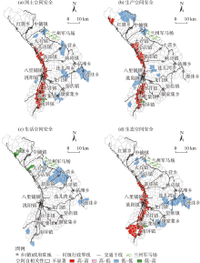
Fig. 4
Local autocorrelation analysis of rural territorial space security in Lintao County"

Tab. 5
Explanatory power of influencing factors on rural territorial space security in Lintao County"
| 探测指标 | 解释力(q) | 探测指标 | 解释力(q) |
|---|---|---|---|
| 海拔(X1) | 0.321*** | 农业总产值(X8) | 0.136 |
| 坡度(X2) | 0.557*** | 政府财政投入(X9) | 0.336*** |
| 地形起伏度(X3) | 0.514*** | 人口密度(X10) | 0.509*** |
| 降水(X4) | 0.129*** | 土地利用强度(X11) | 0.142*** |
| 景观破碎度(X5) | 0.207*** | 乡村道路密度(X12) | 0.031 |
| 乡村工业规模(X6) | 0.043 | 各村质心到中心乡镇最短时间距离成本(X13) | 0.305*** |
| 农民家庭收入(X7) | 0.301*** |
Tab. 6
Interaction detection of rural territorial space security evaluation indices in Lintao County"
| 交互因子 | 作用值 | 交互因子 | 作用值 | 交互因子 | 作用值 |
|---|---|---|---|---|---|
| X1∩X2 | 0.59 | X2∩X11 | 0.57 | X4∩X10 | 0.55 |
| X1∩X3 | 0.57 | X2∩X12 | 0.58 | X5∩X9 | 0.47 |
| X1∩X5 | 0.49 | X2∩X13 | 0.57 | X5∩X10 | 0.61 |
| X1∩X9 | 0.45 | X3∩X4 | 0.63 | X5∩X13 | 0.47 |
| X1∩X10 | 0.57 | X3∩X5 | 0.62 | X6∩X10 | 0.52 |
| X1∩X13 | 0.47 | X3∩X6 | 0.56 | X7∩X9 | 0.46 |
| X2∩X3 | 0.53 | X3∩X7 | 0.57 | X7∩X10 | 0.56 |
| X2∩X4 | 0.63 | X3∩X8 | 0.58 | X8∩X10 | 0.58 |
| X2∩X5 | 0.62 | X3∩X9 | 0.66 | X9∩X10 | 0.60 |
| X2∩X6 | 0.55 | X3∩X10 | 0.64 | X9∩X11 | 0.49 |
| X2∩X7 | 0.60 | X3∩X11 | 0.59 | X9∩X13 | 0.47 |
| X2∩X8 | 0.53 | X3∩X12 | 0.56 | X10∩X11 | 0.55 |
| X2∩X9 | 0.67 | X3∩X13 | 0.57 | X10∩X12 | 0.57 |
| X2∩X10 | 0.62 | X4∩X9 | 0.47 | X10∩X13 | 0.62 |
| [1] |
李繁荣. 中国乡村振兴与乡村功能优化转型[J]. 地理科学, 2021, 41(12): 2158-2167.
doi: 10.13249/j.cnki.sgs.2021.12.009 |
|
[Li Fanrong. Rural revitalization and rural functional optimization and transformation in China[J]. Scientia Geographica Sinica, 2021, 41(12): 2158-2167.]
doi: 10.13249/j.cnki.sgs.2021.12.009 |
|
| [2] | 李瑾, 文琦, 杨骁. 基于资源环境承载力的干旱区乡村振兴路径研究——以宁夏为例[J]. 干旱区地理, 2022, 45(1): 287-297. |
| [Li Jin, Wen Qi, Yang Xiao. Rural revitalization path based on the resources and environment carrying capacity in arid area: A case of Ningxia Hui Autonomous Region[J]. Arid Land Geography, 2022, 45(1): 287-297.] | |
| [3] | 吴文盛, 朱军, 郝志军. 耕地资源的安全评价与预警[J]. 地域研究与开发, 2003, 22(5): 46-49. |
| [Wu Wensheng, Zhu Jun, Hao Zhijun. An evaluation and prediction on the safety of cultivated land resources[J]. Regional Research and Development, 2003, 22(5): 46-49.] | |
| [4] |
Prasood S P, Mukesh M V, Rani V R, et al. Urbanization and its effects on water resources: Scenario of a tropical river basin in south India[J]. Remote Sensing Applications: Society and Environment, 2021, 23: 100556, doi: 10.1016/j.rsase.2021.100556.
doi: 10.1016/j.rsase.2021.100556 |
| [5] | 孙九林. 土地资源安全战略: 认知、目标、研究方向与关键技术[J]. 中国发展, 2019, 19(4): 71-75. |
| [Sun Jiulin. Introduction for land resource security strategy: Recognition, target, research direction and key technology[J]. China Development, 2019, 19(4): 71-75.] | |
| [6] |
Ghosh S, Das C N, Dinda S. Urban ecological security assessment and forecasting using integrated DEMATEL-ANP and CA-Markov models: A case study on Kolkata Metropolitan Area, India[J]. Sustainable Cities and Society, 2021, 68: 102773, doi: 10.1016/j.scs.2021.102773.
doi: 10.1016/j.scs.2021.102773 |
| [7] | 李红, 智硕楠. 新常态下中国能源安全动态研究——基于灰色关联TOPSIS模型[J]. 生态经济, 2020, 36(8): 57-62, 87. |
| [Li Hong, Zhi Shuonan. Dynamic study on China’s energy security under the new normal: Based on gray correlation TOPSIS model[J]. Ecological Economy, 2020, 36(8): 57-62, 87.] | |
| [8] | 李方正, 胡楠, 李雄, 等. 海绵城市建设背景下的城市绿地系统规划响应研究[J]. 城市发展研究, 2016, 23(7): 39-45. |
| [Li Fangzheng, Hu Nan, Li Xiong, et al. Research on response of urban green space system planing under the background of sponge city construction[J]. Urban Development Studies, 2016, 23(7): 39-45.] | |
| [9] | 周霞, 毕添宇, 丁锐, 等. 雄安新区韧性社区建设策略——基于复杂适应系统理论的研究[J]. 城市发展研究, 2019, 26(3): 108-115. |
| [Zhou Xia, Bi Tianyu, Ding Rui, et al. The construction strategy of resilient communities in Xiong’an new area: Based on the theory of complex adaptive systerm[J]. Urban Development Studies, 2019, 26(3): 108-115.] | |
| [10] | 谭纵波. 从公共卫生到国土空间规划——规划的原点与问题意识[J]. 城市发展研究, 2020, 27(3): 10-11. |
| [Tan Zongbo. From public health to territorial and spatial planning: The origin and problem awareness of planning[J]. Urban Development Studies, 2020, 27(3): 10-11.] | |
| [11] |
周侃, 刘宝印, 樊杰. 汶川Ms 8.0地震极重灾区的经济韧性测度及恢复效率[J]. 地理学报, 2019, 74(10): 2078-2091.
doi: 10.11821/dlxb201910009 |
|
[Zhou Kan, Liu Baoyin, Fan Jie. Economic resilience and recovery efficiency in the severely affected of Ms 8.0 Wenchuan earthquake[J]. Acta Geographica Sinica, 2019, 74(10): 2078-2091.]
doi: 10.11821/dlxb201910009 |
|
| [12] |
程钰, 任建兰, 侯纯光, 等. 沿海生态地区空间均衡内涵界定与状态评估——以黄河三角洲高效生态经济区为例[J]. 地理科学, 2017, 37(1): 83-91.
doi: 10.13249/j.cnki.sgs.2017.01.010 |
|
[Cheng Yu, Ren Jianlan, Hou Chunguang, et al. Meaning of space balance and assessing the state of the coastal ecological regions: A case of the Yellow River delta efficient ecological economic zone[J]. Scientia Geographica Sinica, 2017, 37(1): 83-91.]
doi: 10.13249/j.cnki.sgs.2017.01.010 |
|
| [13] |
席广亮, 甄峰, 钱欣彤. 流动性视角下的国土空间安全及规划应对策略[J]. 自然资源学报, 2022, 37(8): 1935-1945.
doi: 10.31497/zrzyxb.20220801 |
|
[Xi Guangliang, Zhen Feng, Qian Xintong. Territory spatial security and planning strategies from the perspective of mobility[J]. Journal of Natural Resources, 2022, 37(8): 1935-1945.]
doi: 10.31497/zrzyxb.20220801 |
|
| [14] | 冯广京, 王睿, 谢莹. 国家治理视域下国土空间概念内涵[J]. 中国土地科学, 2021, 35(5): 8-16. |
| [Feng Guangjing, Wang Rui, Xie Ying. The connotation of territorial space from the perspective of national governance[J]. China Land Science, 2021, 35(5): 8-16.] | |
| [15] | 江曼琦, 刘勇. “三生”空间内涵与空间范围的辨析[J]. 城市发展研究, 2020, 27(4): 43-48, 61. |
| [Jiang Manqi, Liu Yong. Discussion on the concept definition and spatial bounddary classification of “production-living-ecological” space[J]. Urban Development Studies, 2020, 27(4): 43-48, 61.] | |
| [16] |
刘继来, 刘彦随, 李裕瑞. 中国“三生空间”分类评价与时空格局分析[J]. 地理学报, 2017, 72(7): 1290-1304.
doi: 10.11821/dlxb201707013 |
|
[Liu Jilai, Liu Yansui, Li Yurui. Classification evaluation and spatial-temporal analysis of “production-living-ecological” spaces in China[J]. Acta Geographica Sinica, 2017, 72(7): 1290-1304.]
doi: 10.11821/dlxb201707013 |
|
| [17] | 陈佑淋, 余珮珩, 白少云, 等. 面向SDGs的村镇可持续发展质量评估——以杞麓湖流域为例[J]. 中国农业资源与区划, 2020, 41(6): 152-162. |
| [Chen Youlin, Yu Peiheng, Bai Shaoyun, et al. Evaluation on development quality of town and villages considering 2030 sustainable development goals: A case of Qilu Lake watershed[J]. Chinese Journal of Agricultural Resources and Regional Planning, 2020, 41(6): 152-162.] | |
| [18] |
纪学朋, 黄贤金, 陈逸, 等. 基于陆海统筹视角的国土空间开发建设适宜性评价——以辽宁省为例[J]. 自然资源学报, 2019, 34(3): 451-463.
doi: 10.31497/zrzyxb.20190301 |
|
[Ji Xuepeng, Huang Xianjin, Chen Yi, et al. Comprehensive suitability evaluation of spatial development and construction land in the perspective of land-ocean co-ordination: A case study of Liaoning Province, China[J]. Journal of Natural Resources, 2019, 34(3): 451-463.]
doi: 10.31497/zrzyxb.20190301 |
|
| [19] | 于婷婷, 蒋存妍, 冷红, 等. 面向乡村地区国土空间治理的乡村脆弱性评价——理论思考、实证研究与应用展望[J]. 城市规划, 2022, 46(3): 45-53, 73. |
| [Yu Tingting, Jiang Cunyan, Leng Hong, et al. Rural vulnerability assessment for territorial governance in rural areas: Theoretical consideration, empirical study, and application prospect[J]. Journal of Urban Planning, 2022, 46(3): 45-53, 73.] | |
| [20] | 范胜龙, 黄炎和, 林金石, 等. 农用地级别划分的常用方法比较[J]. 中国土地科学, 2010, 24(12): 38-44. |
| [Fan Shenglong, Huang Yanhe, Lin Jinshi, et al. Comparison on the popular methods of agricultural land gradation[J]. China Land Science, 2010, 24(12): 38-44.] | |
| [21] | 马彩虹, 安斯文, 文琦, 等. 基于土地利用转移流的国土空间格局演变及其驱动机制研究——以宁夏原州区为例[J]. 干旱区地理, 2022, 45(3): 925-934. |
| [Ma Caihong, An Siwen, Wen Qi, et al. Spatial pattern evolution and its driving mechanism based on land use transfer flow: A case study in Yuanzhou District in Ningxia[J]. Arid Land Geography, 2022, 45(3): 925-934.] | |
| [22] |
王劲峰, 徐成东. 地理探测器: 原理与展望[J] .地理学报, 2017, 72(1): 116-134.
doi: 10.11821/dlxb201701010 |
|
[Wang Jinfeng, Xu Chengdong. Geodetector: Principle and prospective[J]. Acta Geographica Sinica, 2017, 72(1): 116-134.]
doi: 10.11821/dlxb201701010 |
|
| [23] | 赵育恒, 曾晨. 武汉城市圈生态服务价值时空演变分析及影响因素[J]. 生态学报, 2019, 39(4): 1426-1440. |
| [Zhao Yuheng, Zeng Chen. Analysis of spatial-temporal evolution and factors that influences ecological service values in Wuhan urban agglomeration[J]. Acta Ecologica Sinica, 2019, 39(4): 1426-1440.] | |
| [24] |
宋永永, 薛东前, 夏四友, 等. 近40 a黄河流域国土空间格局变化特征与形成机理[J]. 地理研究, 2021, 40(5): 1445-1463.
doi: 10.11821/dlyj020191065 |
|
[Song Yongyong, Xue Dongqian, Xia Siyou, et al. Change characteristics and formation mechanism of the territorial spatial pattern in the Yellow River Basin form 1980 to 2018, China[J]. Geographical Research, 2021, 40(5): 1445-1463.]
doi: 10.11821/dlyj020191065 |
|
| [25] | 洪惠坤, 谢德体, 郭莉滨, 等. 多功能视角下的山区乡村空间功能分异特征及类型划分[J]. 生态学报, 2017, 37(7): 2415-2427. |
| [Hong Huikun, Xie Deti, Guo Libin, et al. Differentiation of spatial function in a mountainous rural area from a multifunctional perspective[J]. Acta Ecologica Sinica, 2017, 37(7): 2415-2427.] | |
| [26] | 何焱洲, 王成. 乡村生产空间系统功能评价与格局优化——以重庆市巴南区为例[J]. 经济地理, 2019, 39(3): 162-171. |
| [He Yanzhou, Wang Cheng. Function evaluation and pattern optimization of rural production space system: A case study of Banan district in Chongqing[J]. Economic Geography, 2019, 39(3): 162-171.] |
| [1] | GUO Xin, WEI Tianxing, CHEN Yuxuan, SHA Guoliang, REN Kang, YU Huan. Characteristics of soil ecological stoichiometry in typical fallow-restored vegetation in the loess hilly areas [J]. Arid Land Geography, 2022, 45(6): 1899-1907. |
| [2] | MA Caihong,AN Siwen,WEN Qi,HUA Yuqi,LI Conghui. Evolution of territorial spatial pattern and its driving mechanism based on land use transfer flow: A case of Yuanzhou District in Ningxia [J]. Arid Land Geography, 2022, 45(3): 925-934. |
| [3] | DENG Ming-jiang. Development pattern of production-living-ecological spaces and construction of a smart water network system for the Economic Belt on the North Slope of the Tianshan Mountains [J]. Arid Land Geography, 2020, 43(5): 1155-1168. |
|
||