| [1] |
陈晓梅, 杨惠淑. 淤地坝的历史沿革[J]. 河南水利与南水北调, 2007(1): 65-66.
|
|
[ Chen Xiaomei, Yang Huisu. Historical evolution of check dam[J]. Henan Water Resources & South-to-North Water Diversion, 2007(1): 65-66. ]
|
| [2] |
弥智娟, 穆兴民, 赵广举. 基于多源数据的皇甫川淤地坝信息提取[J]. 干旱区地理, 2015, 38(1): 52-59.
|
|
[ Mi Zhijuan, Mu Xingmin, Zhao Guangju. Extraction of check dam based on multi-sources data in the Huangfuchuan watershed[J]. Arid Land Geography, 2015, 38(1): 52-59. ]
|
| [3] |
史红艳. 黄土高原淤地坝防汛监控预警系统建设展望[J]. 中国防汛抗旱, 2019, 29(3): 16-19.
|
|
[ Shi Hongyan. Construction prospect of flood control monitoring and early warning system for check dams in the Loess Plateau[J]. China Flood & Drought Management, 2019, 29(3): 16-19. ]
|
| [4] |
Huang M, Gong J, Shi Z, et al. River bed identification for check-dam engineering using SPOT-5 image in the Hongshimao watershed of the Loess Plateau, China[J]. International Journal of Remote Sensing, 2009, 30(8): 1853-1865.
|
| [5] |
Ratnam K N, Srivastava Y K, Rao V V, et al. Check dam positioning by prioritization of micro-watersheds using SYI model and morphometric analysis: Remote sensing and GIS perspective[J]. Journal of the Indian Society of Remote Sensing, 2005, 33(1): 25-38.
doi: 10.1007/BF02989988
|
| [6] |
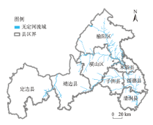
李丽娟, 杨俊伟, 姜德娟, 等. 20世纪90年代无定河流域土地利用的时空变化[J]. 地理研究, 2005, 24(4): 527-534, 656.
|
|
[ Li Lijuan, Yang Junwei, Jiang Dejuan,et al. GIS-based study on spatial-temporal changes of land use in Wuding River Basin in the 1990s[J]. Geographical Research, 2005, 24(4): 527-534, 656. ]
|
| [7] |
佟彪, 党安荣, 周宏宇. 无定河流域城镇聚落的历史演变与人地耦合[J]. 自然资源学报, 2021, 36(1): 38-54.
doi: 10.31497/zrzyxb.20210103
|
|
[ Tong Biao, Dang Anrong, Zhou Hongyu. The historical evolution of urban settlements and man-land coupling in Wuding River Basin[J]. Journal of Natural Resources, 2021, 36(1): 38-54. ]
doi: 10.31497/zrzyxb.20210103
|
| [8] |
潘腾, 关晖, 贺玮. “高分二号”卫星遥感技术[J]. 航天返回与遥感, 2015, 36(4): 16-24.
|
|
[ Pan Teng, Guan Hui, He Wei. GF-2 satellite remote sensing technology[J]. Spacecraft Recovery & Remote Sensing, 2015, 36(4): 16-24. ]
|
| [9] |
张幼莹, 余江宽, 步凡, 等. “高分二号”卫星在黄土地质灾害解译中的应用研究[J]. 测绘与空间地理信息, 2017, 40(11): 31-34, 38.
|
|
[ Zhang Youying, Yu Jiangkuan, Bu Fan, et al. Application of GF-2 satellite to geological hazard interpretation in Loess Plateau[J]. Geomatics & Spatial Information Technology, 2017, 40(11): 31-34,38. ]
|
| [10] |
李思发, 李亮, 赵伟立. GeoEye-1在矿山开发遥感调查中的应用[J]. 工程地球物理学报, 2011, 8(5): 631-634.
|
|
[ Li Sifa, Li Liang, Zhao Weili. Application of GeoEye-1 to remote sensing survey for mine exploitation[J]. Chinese Journal of Engineering Geophysics, 2011, 8(5): 631-634. ]
|
 ),YANG Shuai,HAN Jing,CAO Jiangtao,WANG Ziyao,ZHANG Wenlong(