| [1] |
Givoni M. The development and impact of the modern High Speed Train[J]. Transport Reviews, 2014,26(5):593-612.
doi: 10.1080/01441640600589319
|
| [2] |
潘稼佳. 交通可达性与旅游经济联系的空间关系分析[D]. 乌鲁木齐: 新疆大学, 2019.
|
|
[ Pan Jiajia. Analysis of the spatial relationship between traffic accessibility and tourism economic relationship: Taking 15 prefectures in Xinjiang as an example[D]. Urumqi: Xinjiang University, 2019. ]
|
| [3] |
钟业喜, 陆玉麒. 江苏省城镇可达性格局演变[J]. 长江流域资源与环境, 2011,20(8):903-910.
|
|
[ Zhong Yexi, Lu Yuqi. Urban accessibility and its structure evolution in Jiangsu Province[J]. Resources and Environment in the Yangtze Basin, 2011,20(8):903-910. ]
|
| [4] |
高玉祥, 韩峰, 李泽宇, 等. 基于GIS的轨道交通与旅游热点可达性耦合关系——以天水市为例[J]. 测绘工程, 2019,28(3):57-60, 65.
|
|
[ Gao Yuxiang, Han Feng, Li Zeyu, et al. Study on coupling relations of the important tourism attractions and rail transit based on GIS: A case study of Tianshui[J]. Engineering of Surveying and Mapping, 2019,28(3):57-60, 65. ]
|
| [5] |
周恺, 刘冲. 可视化交通可达性时空压缩格局的新方法——以京津冀城市群为例[J]. 经济地理, 2016,36(7):62-69.
|
|
[ Zhou Kai, Liu Chong. A new method to visualise the time-space compression effect in road network: A case study of Beijing-Tianjing-Hebei region[J]. Economic Geography, 2016,36(7):62-69. ]
|
| [6] |
Mostafa M, Lei Z. Incorporating spatial equity into interurban road network design[J]. Journal of Transport Geography, 2014,39(1):156-164.
doi: 10.1016/j.jtrangeo.2014.06.023
|
| [7] |
潘竟虎, 李俊峰. 中国A级旅游景点空间分布特征与可达性[J]. 自然资源学报, 2014,29(1):55-66.
doi: 10.11849/zrzyxb.2014.01.006
|
|
[ Pan Jinghu, LI Junfeng. Spatial distribution characteristics and accessibility of A-grade tourist attractions in China[J]. Journal of Natural Resources, 2014,29(1):55-66. ]
doi: 10.11849/zrzyxb.2014.01.006
|
| [8] |
韩艳红, 陆玉麒. 南京都市圈可达性与经济联系格局演化研究[J]. 长江流域资源与环境, 2014,23(12):1641-1648.
doi: 10.11870/cjlyzyyhj201412001
|
|
[ Han Yanhong, Lu Yuqi. Analysis of accessibility and economic linkage spatial pattern evolution of Nanjing metroplitan area[J]. Resources and Environment in the Yangtze Basin, 2014,23(12):1641-1648. ]
doi: 10.11870/cjlyzyyhj201412001
|
| [9] |
黄晓燕, 张爽, 曹小曙. 广州市地铁可达性时空演化及其对公交可达性的影响[J]. 地理科学进展, 2014,33(8):1078-1089.
doi: 10.11820/dlkxjz.2014.08.008
|
|
[ Huang Xiaoyan, Zhang Shuang, Cao Xiaoshu. Spatial-temporal evolution of Guangzhou subway accessibility and its effects on the accessibility of public transportation services[J]. Progress in Geography, 2014,33(8):1078-1089. ]
doi: 10.11820/dlkxjz.2014.08.008
|
| [10] |
高玉祥, 韩峰, 袁锋. “一带一路”节点省份铁路路网扩张时空关系研究——以甘肃省为例[J]. 铁道科学与工程学报, 2018,15(8):2172-2178.
|
|
[ Gao Yuxiang, Han Feng, Yuan Feng. Study on temporal-spatial relations of railway network expansion in “the Belt and Road” node province: A case study of Gansu Province[J]. Journal of Railway Science and Engineering, 2018,15(8):2172-2178. ]
|
| [11] |
魏伟, 石培基, 脱敏雍, 等. 基于GIS的甘肃省道路网密度分布特征及空间依赖度分析[J]. 地理科学, 2012,32(11):1297-1303.
|
|
[ Wei Wei, Shi Peiji, Tuo Minyong, et al. The road network density and its spatial dependence in Gansu Province based on GIS[J]. Scientia Geographica Sinica, 2012,32(11):1297-1303. ]
|
| [12] |
杨晓敏, 李玲琴, 付建新, 等. 30 a青海省公路可达性及县域经济联系格局演化[J]. 干旱区地理, 2018,41(6):1376-1387.
|
|
[ Yang Xiaomin, Li Lingqin, Fu Jianxin, et al. Pattern variation of accessibility and economic linkage at county scale in Qinghai Province from 1986 to 2016[J]. Arid Land Geography, 2018,41(6):1376-1387. ]
|
| [13] |
姚兆钊, 曹卫东, 岳洋, 等. 高铁对泛长三角地区可达性格局影响[J]. 长江流域资源与环境, 2018,27(10):2182-2193.
|
|
[ Yao Zhaozhao, Cao Weidong, Yue Yang, et al. Study on the influence of high-speed railway on the accessibility pattern in Pan-Yangtze river delta region[J]. Resources and Environment in the Yangtze Basin, 2018,27(10):2182-2193. ]
|
| [14] |
王雪, 白永平, 汪凡, 等. 基于街道尺度的西安市基础教育资源空间分布特征研究[J]. 干旱区地理, 2019,42(6):1470-1477.
|
|
[ Wang Xue, Bai Yongping, Wang Fan, et al. Characteristics of spatial distribution of basic education resources in Xi’an on street scale[J]. Arid Land Geography, 2019,42(6):1470-1477. ]
|
| [15] |
鲍超, 邹建军. 中国西北地区城镇化质量的时空变化分析[J]. 干旱区地理, 2019,42(5):1141-1152.
|
|
[ Bao Chao, Zou Jianjun. Spatiotemporal variations of urbanization quality in northwest China[J]. Arid Land Geography, 2019,42(5):1141-1152. ]
|
| [16] |
卢茜. 长三角地区高速公路网可达性变化与城市区位分析[D]. 上海: 上海师范大学, 2011.
|
|
[ Lu Qian. Analysis of accessibility change and urban location of expressway network in Yangtze River Delta[D]. Shanghai: Shanghai Normal University, 2011. ]
|
| [17] |
薛冰洁. 珠三角公路运输网络规模的合理性和发展规律研究[D]. 西安: 长安大学, 2011.
|
|
[ Xue Bingjie. Research on the rationality and development law of the scale of the road transportation network in the Pearl River Delta[D]. Xi’an: Chang’an University, 2011. ]
|
| [18] |
周瑞瑞. 宁夏沿黄城市群城镇化质量及时空格局演变特征研究[D]. 银川: 宁夏大学, 2017.
|
|
[ Zhou Ruirui. Study on urbanization quality and spatial-temporal pattern evolution characteristics of Ningxia Urban Agglomeration along the Yellow River[D]. Yinchuan: Ningxia University, 2017. ]
|
| [19] |
宁夏回族自治区统计局. 宁夏统计年鉴2018[M]. 北京: 中国统计出版社, 2018: 26-28.
|
|
[ Statistics Bureau of Ningxia Hui Autonomous Region. Ningxia statistical yearbook 2018[M]. Beijing: China Statistical Publishing House, 2018: 26-28. ]
|
| [20] |
Yin C, He Q, Liu Y, et al. Inequality of public health and its role in spatial accessibility to medical facilities in China[J]. Applied Geography, 2018,92(6):50-62.
doi: 10.1016/j.apgeog.2018.01.011
|
| [21] |
Williams S, Wang F H. Disparities in accessibility of public high schools, in Metropolitan Baton Rouge, Louisiana 1990—2010[J]. Urban Geography, 2014,35(7):1066-1083.
doi: 10.1080/02723638.2014.936668
|
| [22] |
肖冀星, 王振报. 基于GIS的邯郸市医疗服务设施可达性分析[J]. 测绘与空间地理信息, 2020,43(1):137-140, 144.
|
|
[ Xiao Jixing, Wang Zhenbao. Accessibility analysis of medical service facilities in Handan based on GIS[J]. Geomatics & Spatial Information Technology, 2020,43(1):137-140, 144. ]
|
| [23] |
马红伟. 新建包海通道西安至安康高速铁路速度目标值研究[J]. 铁道标准设计, 2019,63(3):7-11.
|
|
[ Ma Hongwei. Research on targeted speed of Xi’an: Ankang high-speed railway on newly built Baotou-Haikou Corridor[J]. Railway Standard Design, 2019,63(3):7-11. ]
|
| [24] |
王辉. 佳木斯至沈阳铁路客运专线速度目标值选择研究[J]. 铁道标准设计, 2017,61(9):1-5.
|
|
[ Wang Hui. Study on selection of target speed value for Jiamusi-Shenyang dedicated passenger railway[J]. Railway Standard Design, 2017,61(9):1-5. ]
|
| [25] |
曹小曙, 李涛, 杨文越, 等. 基于陆路交通的丝绸之路经济带可达性与城市空间联系[J]. 地理科学进展, 2015,34(6):657-664.
doi: 10.18306/dlkxjz.2015.06.001
|
|
[ Cao Xiaoshu, Li Tao, Yang Wenyue, et al. Accessibility and urban spatial connections of cities in the Silk Road Economic Belt based on land transportation[J]. Progress in Geography, 2015,34(6):657-664. ]
doi: 10.18306/dlkxjz.2015.06.001
|
| [26] |
朱杰, 管卫华, 蒋志欣, 等. 江苏省城市经济影响区格局变化[J]. 地理学报, 2007(10):1023-1033.
doi: 10.11821/xb200710002
|
|
[ Zhu Jie, Guan Weihua, Jiang Zhixin, et al. The evolution of urban economic effect regions in Jiangsu Province[J]. Acta Geographica Sinica, 2007(10):1023-1033. ]
doi: 10.11821/xb200710002
|
| [27] |
于策, 李远富, 林芳, 等. 基于GIS的津保铁路对沿线城市可达性影响分析[J]. 铁道运输与经济, 2017,39(5):18-22.
|
|
[ Yu Ce, Li Yuanfu, Lin Fang, et al. Analysis on Influence of Tianjin-Baoding Railway on accessibility of adjacent cities based on GIS[J]. Railway Transport and Economy, 2017,39(5):18-22. ]
|
| [28] |
高玉祥, 韩峰, 任洁, 等. “一带一路”沿线甘肃省铁路网与区域发展的耦合关系研究[J]. 铁道标准设计, 2019,63(8):46-52.
|
|
[ Gao Yuxiang, Han Feng, Ren Jie, et al. Study on the coupling relationship of Gansu railway network and regional development along“the Belt and Road” areas[J]. Railway Standard Design, 2019,63(8):46-52. ]
|
| [29] |
牟乃夏, 刘文宝, 王海银, 等. ArcGIS地理信息系统教程——从初学到精通[M]. 北京: 测绘出版社, 2012: 281-289.
|
|
[ Mu Naixia, Liu Wenbao, Wang Haiyin, et al. ArcGIS geographic information system course: From beginning to proficiency[M]. Beijing: Surveying and Mapping Publishing House, 2012: 281-289. ]
|
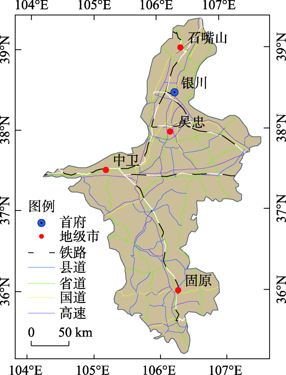
 ),董晓峰2(