- 2025年5月12日 星期一
干旱区地理 ›› 2021, Vol. 44 ›› Issue (4): 1083-1092.doi: 10.12118/j.issn.1000–6060.2021.04.20
卢卓瑜1( ),崔建新1(),张晓虹2,李鹏1
收稿日期:2020-07-08
修回日期:2020-10-04
出版日期:2021-07-25
发布日期:2021-08-02
通讯作者:
崔建新
作者简介:卢卓瑜(1996-),男,硕士,主要从事历史环境变迁与重建研究. E-mail: 基金资助:
LU Zhuoyu1(),CUI Jianxin1(),ZHANG Xiaohong2,LI Peng1
Received:2020-07-08
Revised:2020-10-04
Online:2021-07-25
Published:2021-08-02
Contact:
Jianxin CUI
摘要:
干旱区湖泊是环境变迁中最为敏感的地理实体之一,因此一直是历史沙漠地理研究中的重要载体。清代毛乌素沙地南缘的佟哈拉克泊又称清湖、青山湖,其定位及所纳河流今天仍有争议。通过运用古今地名定位、史料分析、地理信息系统(GIS)和遥感(RS)等方法,判断佟哈拉克泊位于今天的靖边县宁条梁镇以北的平坦地带,所纳河流应为今天的红柳河,在清末以后逐渐消亡。毛乌素沙地是人类活动改变自然环境的典型地区,佟哈拉克泊的消失跟小冰期气候背景下清代禁留地放垦、伙盘地开发有很大关系。因此,佟哈拉克泊的复原与演变研究对于揭示人类活动与环境之间的互动关系有一定的指示意义。
卢卓瑜,崔建新,张晓虹,李鹏. 清至民国毛乌素沙地佟哈拉克泊复原及演变研究[J]. 干旱区地理, 2021, 44(4): 1083-1092.
LU Zhuoyu,CUI Jianxin,ZHANG Xiaohong,LI Peng. Historical changes reconstruction of Tonghalake Lake in the Mu Us Sandy Land from Qing Dynasty to Republic of China[J]. Arid Land Geography, 2021, 44(4): 1083-1092.
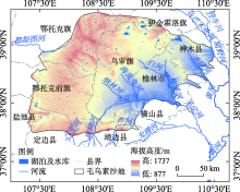
图1
毛乌素沙地当代水系"

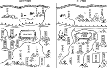
图2
《陕西四镇图说》记载的古湖泊位置 注:该图据明残本《陕西四镇图说》影印图像重绘,资料来源于世界数字图书馆(https://www.wdl.org/zh/),古籍原件藏于台湾中央图书馆。"

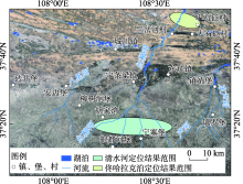
图3
历史文献所载佟哈拉克泊位置的定位范围"
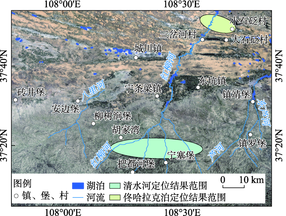
表1
文献所载里程与实际距离对比"
| 参考地物 | 文献记载距离/里 | 换算距离a/km | 实际直线距离/km | 估算实际道路距离b/km |
|---|---|---|---|---|
| 左翼中旗(今伊金霍洛旗阿勒腾席热镇)至神木(今神木市)界 | 200 | 124.20 | 99 | 122 |
| 右翼前旗(今乌审旗东北巴吉代)至榆林(今榆林市榆阳区)界 | 230 | 142.83 | 99 | 136 |
表2
《皇舆全览图》地理坐标差值及其偏移距离"
| 参考地物 | 图上坐标与实地坐标差值 | 偏移距离/km | |
|---|---|---|---|
| 经度差/(°) | 纬度差/(°) | ||
| 安定堡 | -0.0142 | -0.0355 | 4.1355 |
| 高平堡 | -0.0288 | -0.0154 | 3.0616 |
| 花马池 | -0.0286 | -0.0401 | 5.1222 |
| 盐场堡 | -0.0452 | 0.0091 | 4.1185 |
| 定边营 | 0.0121 | 0.0092 | 1.4818 |
| 砖井堡 | 0.0228 | 0.0295 | 3.8468 |
| 安边堡 | -0.0042 | 0.0231 | 2.5860 |
| 宁塞堡 | -0.0017 | 0.0014 | 0.2185 |
| 靖边营 | 0.0327 | -0.0049 | 2.9528 |
| 镇罗堡 | -0.0141 | -0.0011 | 1.2578 |
| 镇靖堡 | 0.0015 | -0.0216 | 2.4025 |
| 龙州堡 | -0.0088 | -0.0033 | 0.8607 |
| 榆林卫 | 0.0077 | -0.0805 | 8.9563 |
| 高家堡 | -0.0114 | -0.0503 | 5.6685 |
| 柏林堡 | 0.0086 | 0.0469 | 5.2555 |
| 神木县 | -0.0381 | 0.0073 | 3.4020 |
| 孤山堡 | 0.0020 | -0.0116 | 1.2952 |
| 府谷县 | 0.0358 | 0.0034 | 3.1170 |
| 差值平均数 | -0.0040 | -0.0075 | 3.3189 |
表3
《雍正十排图》地理坐标差值及其偏移距离"
| 参考地物 | 图上坐标与实地坐标差值 | 偏移距离/km | |
|---|---|---|---|
| 经度差/(°) | 纬度差/(°) | ||
| 安定堡 | 0.0006 | -0.0060 | 0.6645 |
| 高平堡 | 0.0073 | -0.0030 | 0.7237 |
| 花马池 | -0.0127 | -0.0080 | 1.4305 |
| 盐场堡 | 0.0332 | -0.0322 | 4.6268 |
| 定边县 | 0.0366 | 0.0006 | 3.2366 |
| 砖井堡 | 0.0709 | 0.0185 | 6.5967 |
| 安边堡 | 0.0260 | 0.0303 | 4.0750 |
| 宁塞堡 | 0.0069 | 0.0198 | 2.2775 |
| 靖边营 | 0.0078 | 0.0205 | 2.3798 |
| 镇罗堡 | -0.0452 | 0.0257 | 4.9184 |
| 镇靖堡 | -0.0075 | -0.0015 | 0.6880 |
| 龙州堡 | -0.0071 | 0.0097 | 1.2439 |
| 榆林卫 | -0.0637 | -0.0261 | 6.2836 |
| 高家堡 | 0.0235 | -0.0846 | 9.6058 |
| 柏林堡 | 0.0187 | 0.0345 | 4.1580 |
| 神木县 | 0.0891 | 0.0432 | 9.0978 |
| 孤山堡 | -0.0205 | 0.0233 | 3.1378 |
| 府谷县 | -0.0376 | 0.0006 | 3.2578 |
| 差值平均数 | 0.0070 | 0.0036 | 3.8001 |
表4
《乾隆内府舆图》地理坐标差值及其偏移距离"
| 参考地物 | 图上坐标与实地坐标差值 | 偏移距离/km | |
|---|---|---|---|
| 经度差/(°) | 纬度差/(°) | ||
| 安定堡 | 0.0276 | -0.0073 | 2.5578 |
| 高平堡 | -0.0077 | 0.0295 | 3.3489 |
| 花马池 | -0.0462 | -0.0011 | 4.0770 |
| 盐场堡 | -0.0817 | 0.0331 | 8.0928 |
| 定边县 | 0.0090 | 0.0549 | 6.1524 |
| 砖井堡 | 0.0411 | -0.0202 | 4.2687 |
| 安边堡 | -0.0122 | -0.0367 | 4.2121 |
| 宁塞堡 | -0.0110 | -0.0031 | 1.0326 |
| 靖边县 | 0.0110 | -0.0213 | 2.5616 |
| 镇罗堡 | 0.0121 | 0.0548 | 6.1763 |
| 镇靖堡 | 0.1016 | -0.0277 | 9.4950 |
| 龙州堡 | -0.0011 | 0.0567 | 6.2919 |
| 榆林县 | 0.0012 | -0.0676 | 7.5041 |
| 高家堡 | -0.0652 | -0.0130 | 5.8603 |
| 柏林堡 | -0.0602 | 0.0101 | 5.3618 |
| 神木县 | -0.0728 | 0.0442 | 8.0018 |
| 孤山堡 | -0.0038 | 0.0132 | 1.5063 |
| 府谷县 | -0.0315 | 0.0313 | 4.4174 |
| 差值平均值 | -0.0105 | 0.0072 | 5.0510 |
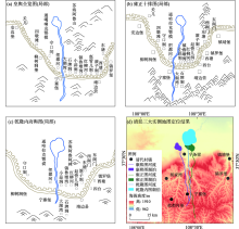
图4
清廷三大实测地图佟哈拉克泊定位结果"

| [1] | 胡汝骥, 姜逢清, 王亚俊, 等. 论中国干旱区湖泊研究的重要意义[J]. 干旱区研究, 2007, 24(2):137-140. |
| [ Hu Ruji, Jiang Fengqing, Wang Yajun, et al. On the importance of research on the lakes in arid land of China[J]. Arid Zone Research, 2007, 24(2):137-140. ] | |
| [2] | 桑广书, 李芳, 杨晓敏. 鄂尔多斯高原明长城的地理界线意义[J]. 干旱区地理, 2017, 40(3):485-493. |
| [ Sang Guangshu, Li Fang, Yang Xiaomin. Significance of the Great Wall of Ming Dynasty in Ordos Plateau as geographical boundary[J]. Arid Land Geography, 2017, 40(3):485-493. ] | |
| [3] |
Liu K, Lai Z P. Chronology of Holocene sediments from the archaeological Salawusu site in the Mu Us Desert in China and its palaeoenvironmental implications[J]. Journal of Asian Earth Sciences, 2012, 45:247-255.
doi: 10.1016/j.jseaes.2011.11.002 |
| [4] |
舒培仙, 李保生, 牛东风, 等. 毛乌素沙漠东南缘滴哨沟湾剖面DGS1层段粒度特征及其指示的全新世气候变化[J]. 地理科学, 2016, 36(3):448-457.
doi: 10.13249/j.cnki.sgs.2016.03.017 |
|
[ Shu Peixian, Li Baosheng, Niu Dongfeng, et al. Climate variations recorded by the grain-size from the DGS1 segment in the southeast of China’s Mu Us Desert during the Holocene[J]. Scientia Geographica Sinica, 2016, 36(3):448-457. ]
doi: 10.13249/j.cnki.sgs.2016.03.017 |
|
| [5] |
Jia F F, Lu R J, Liu X K, et al. Palaeoenvironmental implications of a Holocene sequence of lacustrine-peat sediments from the desert-loess transitional zone in northern China[J]. Journal of Asian Earth Sciences, 2018, 156:167-173.
doi: 10.1016/j.jseaes.2018.01.030 |
| [6] | 侯仁之. 从红柳河上的古城废墟看毛乌素沙漠的变迁[J]. 文物, 1973(1):35-41. |
| [ Hou Renzhi. From the ruins of the ancient city on the Red Willow River to see the changes of the Mu Us Desert[J]. Cultural Relics, 1973(1):35-41. ] | |
| [7] | 朱士光. 内蒙城川地区湖泊的古今变迁及其与农垦之关系[J]. 农业考古, 1982(1):14-18, 157. |
| [ Zhu Shiguang. The ancient and modern changes of lakes in the Chengchuan area of Inner Mongolia and its relationship with farmland reclamation[J]. Agricultural Archaeology, 1982(1):14-18, 157. ] | |
| [8] |
Huang Y Z, Wang N A, He T H, et al. Historical desertification of the Mu Us Desert, northern China: A multidisciplinary study[J]. Geomorphology, 2009, 110(3-4):108-117.
doi: 10.1016/j.geomorph.2009.03.020 |
| [9] |
Cui J X, Chang H, Cheng K Y, et al. Climate change, desertification, and societal responses along the Mu Us Desert margin during the Ming Dynasty[J]. Weather, Climate, and Society, 2017, 9(1):81-94.
doi: 10.1175/WCAS-D-16-0015.1 |
| [10] | 赵永复. 历史上毛乌素沙地的变迁问题[J]. 历史地理, 1981(1):34-47. |
| [ Zhao Yongfu. Changes of the Mu Us Sandy Land in history[J]. Historical Geography, 1981(1):34-47. ] | |
| [11] | 高嘉诚. 清代鄂尔多斯高原水环境的历史考察[D]. 西安: 陕西师范大学, 2005. |
| [ Gao Jiacheng. The historical investigation of the the Qing’s water environment in Ordos Plateau[D]. Xi’an: Shaanxi Normal University, 2005. ] | |
| [12] | 罗凯, 安介生. 清代鄂尔多斯水文系统初探[C]//侯甬坚. 鄂尔多斯高原及其邻区历史地理研究. 西安: 三秦出版社, 2008: 274-297. |
| [ Luo Kai, An Jiesheng. A preliminary study of the Ordos hydrological system in the Qing Dynasty[C]//Hou Yongjian. Research on the historical geography of the Ordos Plateau and its neighboring areas. Xi’an: Sanqin Publishing House, 2008: 274-297. ] | |
| [13] | 黄银洲, 李婧, 付娇, 等. 萨拉乌苏河对芦河的袭夺及其历史地理意义[J]. 中国沙漠, 2020, 40(3):7-15. |
| [ Huang Yinzhou, Li Jing, Fu Jiao, et al. River piracy of the Lu River by the Salawusu River and its historical-geographical significance[J]. Journal of Desert Research, 2020, 40(3):7-15. ] | |
| [14] | 张莉, 李有利. 近300年来新疆玛纳斯湖变迁研究[J]. 中国历史地理论丛, 2004, 19(4):127-142, 160. |
| [ Zhang Li, Li Youli. On the changes of Manas Lake in the past 300 years[J]. Journal of Chinese Historical Geography, 2004, 19(4):127-142, 160. ] | |
| [15] | 何彤慧, 王乃昂, 黄银洲, 等. 毛乌素沙地古城反演的地表水环境变化[J]. 中国沙漠, 2010, 30(3):471-476. |
| [ He Tonghui, Wang Nai’ang, Huang Yinzhou, et al. Surface water environment change of the Mu Us Desert during historic times: An ancient city perspective[J]. Journal of Desert Research, 2010, 30(3):471-476. ] | |
| [16] | 邓辉, 李羿. 人地关系视角下明清时期京津冀平原东淀湖泊群的时空变化[J]. 首都师范大学学报(社会科学版), 2018, 243(4):95-105. |
| [ Deng Hui, Li Yi. The temporal and spatial changes of the Dongdian Lake Group in the Jingjinji Plain in the Ming and Qing Dynasties from the perspective of human-land relationship[J]. Journal of Capital Normal University(Social Sciences Edition), 2018, 243(4):95-105. ] | |
| [17] |
杨霄, 韩昭庆. 1717—2011年高宝诸湖的演变过程及其原因分析[J]. 地理学报, 2018, 73(1):129-137.
doi: 10.11821/dlxb201801011 |
|
[ Yang Xiao, Han Zhaoqing. The change of the Gaobao lakes and its driving forces (1717—2011)[J]. Acta Geography Sinica, 2018, 73(1):129-137. ]
doi: 10.11821/dlxb201801011 |
|
| [18] | 王涛. 中国北方沙漠与沙漠化图集[M]. 北京: 科学出版社, 2014: 22. |
| [ Wang Tao. Atlas of deserts and desertification in northern China[M]. Beijing: Science Press, 2014: 22. ] | |
| [19] | 闫峰, 吴波. 近40 a毛乌素沙地荒漠化过程研究[J]. 干旱区地理, 2013, 36(6):987-996. |
| [ Yan Feng, Wu Bo. Desertification progress in Mu Us Sandy Land over the past 40 years[J]. Arid Land Geography, 2013, 36(6):987-996. ] | |
| [20] | 张佩云, 王凯, 王戈飞, 等. 毛乌素沙地中部地表水体1999—2015时空动态变化特征及驱动分析[J]. 干旱区地理, 2017, 40(3):633-639. |
| [ Zhang Peiyun, Wang Kai, Wang Gefei, et al. Spatial-temporal changes and factor analysis of surface water in the middle Mu Us Sandy Land areas from 1999 to 2015[J]. Arid Land Geography, 2017, 40(3):633-639. ] | |
| [21] | 牛润珍, 张慧. 《大清一统志》纂修考述[J]. 清史研究, 2008(1):136-148. |
| [ Niu Runzhen, Zhang Hui. The compilation of gazetteer of the unified Great Qing[J]. The Qing History Journal, 2008(1):136-148. ] | |
| [22] | 韩昭庆. 康熙《皇舆全览图》的数字化及意义[J]. 清史研究, 2016(4):53-60. |
| [ Han Zhaoqing. The digitization of Kangxi complete atlas of imperial tenitories and its significance for the study of environmental change and historical geography[J]. The Qing History Journal, 2016(4):53-60. ] | |
| [23] | 喻沧, 刘自健. 《中国测绘史》编辑委员会编. 中国测绘史[M]. 北京: 测绘出版社, 2002: 571-579. |
| [ Yu Cang, Liu Zijian. Edited by the Editorial Committee of “History of Surveying and Mapping in China”. History of surveying and mapping in China[M]. Beijing: Surveying and Mapping Press, 2002: 571-579. ] | |
| [24] | 陆俊巍, 韩昭庆, 诸玄麟, 等. 康熙《皇舆全览图》投影种类的统计分析[J]. 测绘科学, 2011, 36(6):16-18, 27. |
| [ Lu Junwei, Han Zhaoqing, Zhu Xuanlin, et al. A statistical analysis on the projection type applied in Huang Yu Quan Lan Tu[J]. Science of Surveying and Mapping, 2011, 36(6):16-18, 27. ] | |
| [25] | (清) 穆彰阿, 潘锡恩. 大清一统志(第12册)[M]. 上海: 上海古籍出版社, 2008: 599-602. |
| [(Qing) Mu Zhang’a, Pan Xi’en. Chorography in Qing Dynasty(Vol.12)[M]. Shanghai: Shanghai Ancient Books Publishing House, 2008: 599-602. ] | |
| [26] | 李大海. 明清时期陕北宁塞营堡城址考辩——兼及明代把都河、永济诸堡的定位[C]//侯甬坚. 鄂尔多斯高原及其邻区历史地理研究. 西安: 三秦出版社, 2008: 274-297. |
| [ Li Dahai. A research on the city site of Ningsaiyingbao in northern Shaanxi during the Ming and Qing Dynasties and the position of Badu River and Yongji castles in the Ming Dynasty[C]//Hou Yongjian. Research on the historical geography of the Ordos Plateau and its neighboring areas. Xi’an: Sanqin Publishing House, 2008: 274-297. ] | |
| [27] | (清) 张穆. 蒙古游牧记[M]. 台北: 文海出版社, 1965: 255. |
| [(Qing) Zhang Mu. Mongolian nomads[M]. Taipei: Wenhai Publishing House, 1965: 255. ] | |
| [28] | 伊克昭盟地名委员会. 伊克昭盟地名志[R]. 呼和浩特: 内蒙古自治区地名委员会, 1986: 318. |
| [Place Names Committee of Yikezhao League. Place names of Yikezhao League[R]. Hohhot: Place Names Committee of Inner Mongolia Autonomous Region, 1986: 318. ] | |
| [29] | (比) 田清波. 对萨囊·彻辰的曾祖父——库图克台·彻辰·洪·台吉的说明[C]// 伊克昭盟档案馆. 鄂尔多斯研究文集第一辑(内部资料). 鄂尔多斯: 内蒙古伊克昭盟档案馆, 1984: 73-78. |
| [ Antoine Mostaert. An explanation of Kutuket Chechen Hong Taiji, great grandfather of Sagang Chechen[C]// Yikezhao League Archives. Research essays of Ordos, Volume 1(internal publication). Ordos: Inner Mongolia Yikezhao League Archives, 1984: 73-78. ] | |
| [30] | (清) 萨囊彻辰, 道润梯步译校. 蒙古源流(新译校注)[M]. 呼和浩特: 内蒙古人民出版社, 1980: 353. |
| [(Qing) Sagang Chechen, Translated by Daorun Tibu. Origin of Mongolia(New Translation Notes)[M]. Hohhot: Inner Mongolia People’s Publishing House, 1980: 353. ] | |
| [31] | 汪前进, 刘若芳. 清廷三大实测全图集[M]. 北京: 外文出版社, 2007. |
| [ Wang Qianjin, Liu Ruofang. The Qing Dynasty three surveyed map[M]. Beijing: Foreign Languages Press, 2007. ] | |
| [32] | 白壮壮. 清代以来鄂尔多斯高原沙漠化定量研究[D]. 西安: 陕西师范大学, 2020. |
| [ Bai Zhuangzhuang. Quantitative research on the desertification of the Ordos Plateau since the Qing Dynasty[D]. Xi’an: Shaanxi Normal University, 2020. ] | |
| [33] | 绥远通志馆编纂. 绥远通志稿(第1册)[M]. 呼和浩特: 内蒙古人民出版社, 2007: 402. |
| [Compiled by Suiyuan Tongzhi Department. Suiyuan tongzhi draft(Vol. 1)[M]. Hohhot: Inner Mongolia People’s Publishing House, 2007: 402. ] | |
| [34] | 罗小庆, 赵景波, 马晓华. 陕西省榆林地区1644—1949年旱灾与干旱气候事件[J]. 水土保持通报, 2015, 35(1):311-316. |
| [ Luo Xiaoqing, Zhao Jingbo, Ma Xiaohua. Drought disaster and drought events in Yulin area of Shaanxi Province from 1644 to 1949[J]. Bulletin of Soil and Water Conservation, 2015, 35(1):311-316. ] | |
| [35] | 李明启, 靳鹤龄, 张洪. 小冰期气候的研究进展[J]. 中国沙漠, 2005, 25(5):731-737. |
| [ Li Mingqi, Jin Heling, Zhang Hong. Advances of climate research in the Little Ice Age[J]. Journal of Desert Research, 2005, 25(5):731-737. ] | |
| [36] | 白壮壮, 崔建新. 近2000 a毛乌素沙地沙漠化及成因[J]. 中国沙漠, 2019, 39(2):177-185. |
| [ Bai Zhuangzhuang, Cui Jianxin. Desertification and its causes in Mu Us Desert in recent 2000 years[J]. Journal of Desert Research, 2019, 39(2):177-185. ] | |
| [37] | 张世明. 清代“烧荒”考[J]. 清史研究, 2005(3):85-88. |
| [ Zhang Shiming. Textual research on “Burning Waste” in the Qing Dynasty[J]. The Qing History Journal, 2005(3):85-88. ] | |
| [38] | 张力仁. 清代伊克昭盟南部“禁留地”新探[J]. 中国历史地理论丛, 2018, 33(4):87-94. |
| [ Zhang Liren. New exploration of the “Forbidden Land” in the southern part of Yike Zhao League in the Qing Dynasty[J]. Journal of Chinese Historical Geography, 2018, 33(4):87-94. ] | |
| [39] | 王晗. 清代陕北长城外伙盘地研究[D]. 西安: 陕西师范大学, 2005. |
| [ Wang Han. The disquisition on Huo Pan Di at the outside of the Great Wall in the north of Shaanxi in the Qing Dynasty[D]. Xi’an: Shaanxi Normal University, 2005. ] | |
| [40] | (清) 白翰章. 靖边县志稿[M]. 台北: 成文出版社, 1970: 313. |
| [(Qing) Bai Hanzhang. Chorography manuscript of Jingbian County[M]. Taipei: Chengwen Publishing House, 1970: 313. ] | |
| [41] | 王晗, 郭平若. 清代垦殖政策与陕北长城外的生态环境[J]. 史学月刊, 2007(4):86-93. |
| [ Wang Han, Guo Pingruo. The Qing Dynasty reclamation policy and ecological environment outside the Great Wall in northern Shaanxi[J]. Journal of Historical Science, 2007(4):86-93. ] | |
| [42] | 西北大学地理系《陕西农业地理》编写组编. 陕西农业地理[M]. 西安: 陕西人民出版社, 1979: 123. |
| [Editing group of Shaanxi Agricultural Geography, Geography Department of Northwest University. Shaanxi agricultural geography[M]. Xi’an: Shaanxi People’s Publishing House, 1979: 123. ] |
| [1] | 潘雪, 关宇淇, 潘占东, 刘杰, 蔡立群, 董博, 杜健. 干旱区耕地质量等级时空变化及其评价——以西宁市为例[J]. 干旱区地理, 2023, 46(5): 793-803. |
| [2] | 谢聪慧,吴世新,林娟,庄庆威,张子慧,侯冠宇,罗格平. 基于PSO-PNN模型的喀什噶尔绿洲耕地盐渍化分析[J]. 干旱区地理, 2022, 45(5): 1547-1558. |
| [3] | 贺军奇,魏燕,高万德,陈云飞,马延东,刘秀花. 毛乌素沙地东南缘植被NDVI时空变化及其对气候因子的响应[J]. 干旱区地理, 2022, 45(5): 1523-1533. |
| [4] | 崔颖颖, 周亚利, 陈国祥, 黄春长, 庞奖励, 羊俊敏, 闫雪娇. 毛乌素沙地样品扫描电镜的矿物定量分析[J]. 干旱区地理, 2020, 43(6): 1505-1513. |
| [5] | 王 陇, 高广磊, 张 英, 丁国栋, 赵媛媛, 彭 玏. 毛乌素沙地风沙土粒径分布特征及其影响因素[J]. 干旱区地理, 2019, 42(5): 1003-1010. |
| [6] | 张佩云, 王凯, 王戈飞, 梁枥文, 张世强. 毛乌素沙地中部地表水体1999-2015时空动态变化特征及驱动分析[J]. 干旱区地理, 2017, 40(3): 633-639. |
| [7] | 闫峰,吴波. 近40 a毛乌素沙地荒漠化过程研究[J]. 干旱区地理, 2013, 36(6): 987-996. |
| Viewed | ||||||||||||||||||||||||||||||||||||||||||||||||||
|
Full text 352
|
|
|||||||||||||||||||||||||||||||||||||||||||||||||
|
Abstract 370
|
|
|||||||||||||||||||||||||||||||||||||||||||||||||
Cited |
|
|||||||||||||||||||||||||||||||||||||||||||||||||
| Shared | ||||||||||||||||||||||||||||||||||||||||||||||||||
|
||