| [1] |
杨人懿, 杨子生, 钟昌标, 等. 中国耕地-粮食丰裕度与居民收入的关系研究[J]. 自然资源学报, 2024, 39(11): 2619-2638.
doi: 10.31497/zrzyxb.20241108
|
|
[Yang Renyi, Yang Zisheng, Zhong Changbiao, et al. Study on the relationship between farmland & grain abundance and households’ income in China[J]. Journal of Natural Resources, 2024, 39(11): 2619-2638.]
doi: 10.31497/zrzyxb.20241108
|
| [2] |
余森, 马恩朴, 季艺雯, 等. 中国北方典型样带耕地多功能时空演变及其区际耦合[J]. 自然资源学报, 2025, 40(2): 514-533.
doi: 10.31497/zrzyxb.20250214
|
|
[Yu Sen, Ma Enpu, Ji Yiwen, et al. Multifunctional spatiotemporal evolution and its inter-regional coupling of cultivated land in a typical transect in northern China[J]. Journal of Natural Resources, 2025, 40(2): 514-533.]
doi: 10.31497/zrzyxb.20250214
|
| [3] |
新华社. 中共中央国务院关于进一步深化农村改革扎实推进乡村全面振兴的意见[EB/OL]. [2025-01-01]. https://m.cyol.com/gb/articles/2025-02/23/content_99a97xfa3M.html.
|
|
[Xinhua News Agency. Opinions of the CPC central committee and the state council on further deepening rural reform and solidly advancing the comprehensive revitalization of rural areas[EB/OL]. [2025-01-01]. https://m.cyol.com/gb/articles/2025-02/23/content_99a97xfa3M.html. ]
|
| [4] |
求是网. 习近平主持召开中央全面深化改革委员会第十九次会议[EB/OL]. [2021-05-21]. http://www.qstheory.cn/yaowen/2021-05/21/c_1127476538.htm.
|
|
[Qiushi. Xi Jinping chaired the 19th meeting of the commission for deepening overall reform of the CPC central committee[EB/OL]. [2021-05-21]. http://www.qstheory.cn/yaowen/2021-05/21/c_1127476538.htm. ]
|
| [5] |
自然资源部. 2017中国土地矿产海洋资源统计公报[EB/OL]. [2018-05-18]. https://gi.mnr.gov.cn/201805/t20180518_1776792.html.
|
|
[Ministry of Natural Resources. Statistical bulletin of China’s land, mineral and marine resources in 2017[EB/OL]. [2018-05-18]. https://gi.mnr.gov.cn/201805/t20180518_1776792.html. ]
|
| [6] |
王博杰, 何思源, 闵庆文, 等. 守望农耕文明: 农户对传统农业系统的价值认知如何影响其传承意愿[J]. 中国农村经济, 2024(11): 125-146.
|
|
[Wang Bojie, He Siyuan, Min Qingwen, et al. Guarding the agricultural civilization: How does rural households’ value perceptions of traditional agricultural systems affect their willingness to inherit?[J]. Chinese Rural Economy, 2024(11): 125-146.]
|
| [7] |
孙儒泳. 生态学简介(六)[J]. 生物学通报, 1982(1): 25-29.
|
|
[Sun Ruyong. Introduction to ecology (VI)[J]. Bulletin of Biology, 1982(1): 25-29.]
|
| [8] |
Schaltegger S, Sturm A. Environmental rationality[J]. Die Unternehmun, 2001, 2(3): 288-289.
|
| [9] |
WBCSD. Eco-efficiency learning module[EB/OL]. [2006-08-24]. https://docs.wbcsd.org/2006/08/EfficiencyLearningModule.pdf.
|
| [10] |
Keating B A, Carberry P S, Bindraban P S, et al. Eco-efficient agriculture: Concepts, challenges, and opportunities[J]. Crop Science, 2010, 50(2): 109-119.
doi: 10.2135/cropsci2009.10.0594
|
| [11] |
陈杰, 许朗. 基于面板三阶段DEA-Malmquist模型的中国农业绿色水资源利用效率研究[J]. 地理科学, 2023, 43(4): 709-718.
doi: 10.13249/j.cnki.sgs.2023.04.014
|
|
[Chen Jie, Xu Lang. Utilization efficiency of Chinese agricultural green water resources based on panel three-stage DEA-Malmquist model[J]. Scientia Geographica Sinica, 2023, 43(4): 709-718.]
doi: 10.13249/j.cnki.sgs.2023.04.014
|
| [12] |
徐维祥, 徐志雄, 刘程军. 基于随机前沿分析的环境规制效率异质性研究[J]. 地理科学, 2021, 41(11): 1959-1968.
doi: 10.13249/j.cnki.sgs.2021.11.009
|
|
[Xu Weixiang, Xu Zhixiong, Liu Chengjun. Heterogenity analysis of environmental regulation efficiency based on SFA[J]. Scientia Geographica Sinica, 2021, 41(11): 1959-1968.]
doi: 10.13249/j.cnki.sgs.2021.11.009
|
| [13] |
肖琴, 罗其友, 周振亚, 等. 中国农业绿色生产效率的动态变迁与空间分异——基于DDF-Global Malmquist-Luenberger指数方法的分析[J]. 农林经济管理学报, 2020, 19(5): 537-547.
|
|
[Xiao Qin, Luo Qiyou, Zhou Zhenya, et al. Dynamic evolution and spatial differentiation of agricultural green production efficiency in China: An analysis based on DDF-Global Malmquist-Luenberger index[J]. Journal of Agro-Forestry Economics and Management, 2020, 19(5): 537-547.]
|
| [14] |
武音茜. 贵州省经济发展中的能源利用效率与节能减排绩效研究——基于非径向DEA方法RAM模型[J]. 西南民族大学学报(人文社会科学版), 2014, 35(9): 109-113.
|
|
[Wu Yinqian. Energy utilization efficiency and emission reduction performance in Guizhou’s economic development: A non-radial DEA-RAM model approach[J]. Journal of Southwest Minzu University (Humanities and Social Sciences Edition), 2014, 35(9): 109-113.]
|
| [15] |
成刚. 数据包络分析方法与MaxDEA软件[M]. 北京: 知识产权出版社, 2014: 151-171.
|
|
[Cheng Gang. Data envelopment analysis: methods and MaxDEA software[M]. Beijing: Intellectual Property Publishing House, 2014: 151-171.]
|
| [16] |
程娟娟, 王倩, 余劲, 等. 基于LCA和SBM模型的苹果生产环境效率评价[J]. 干旱区资源与环境, 2022, 36(3): 36-43.
|
|
[Cheng Juanjuan, Wang Qian, Yu Jin, et al. Evalution of environmental efficiency of apple production based on LCA and SBM models[J]. Journal of Arid Land Resources and Environment, 2022, 36(3): 36-43.]
|
| [17] |
向慧, 彭保发, 伍铁牛, 等. 湖南武陵民族地区种植业生态效率的时空分异及驱动机理研究[J]. 地理科学, 2025, 45(2): 349-363.
doi: 10.13249/j.cnki.sgs.20230470
|
|
[Xiang Hui, Peng Baofa, Wu Tieniu, et al. Spatio-temporal pattern and driving mechanism of agricultural ecological efficiency for planting industry in the Wuling ethnic area of Hunan[J]. Scientia Geographica Sinica, 2025, 45(2): 349-363.]
doi: 10.13249/j.cnki.sgs.20230470
|
| [18] |
朱红波, 丁未来, 周瑞彤. 长江经济带耕地利用生态效率评价与空间格局分析[J]. 长江流域资源与环境, 2025, 34(1): 87-99.
|
|
[Zhu Hongbo, Ding Weilai, Zhou Ruitong. Evaluation of ecological efficiency and spatial pattern analysis of cultivated land utilization in the Yangtze River Economic Zone[J]. Resources and Environment in the Yangtze Basin, 2025, 34(1): 87-99.]
|
| [19] |
吴海霞, 郝含涛, 葛岩. 粮食主产区政策对农业环境全要素生产率的效应评估[J]. 资源科学, 2022, 44(2): 334-349.
doi: 10.18402/resci.2022.02.10
|
|
[Wu Haixia, Hao Hantao, Ge Yan. Effect evaluation of the main grain producing area policy on agricultural environmental total factor productivity[J]. Resources Science, 2022, 44(2): 334-349.]
doi: 10.18402/resci.2022.02.10
|
| [20] |
马林燕, 张仁慧, 潘子纯, 等. 中国省际耕地利用生态效率时空格局演变及影响因素分析——基于2000—2019年面板数据[J]. 中国土地科学, 2022, 36(3): 74-85.
|
|
[Ma Linyan, Zhang Renhui, Pan Zichun, et al. Analysis of the evolution and influencing factors of temporal and spatial pattern of eco-efficiency of cultivated land use among provinces in China: Based on panel data from 2000 to 2019[J]. China Land Science, 2022, 36(3): 74-85.]
|
| [21] |
朱文娟, 孙华. 江苏省县域耕地利用生态效率时空动态性及驱动机制[J]. 长江流域资源与环境, 2024, 33(4): 784-798.
|
|
[Zhu Wenjuan, Sun Hua. Spatio-temporal dynamics and driving mechanism of cultivated land use eco-efficiency at county scale in Jiangsu Province[J]. Re-sources and Environment in the Yangtze Basin, 2024, 33(4): 784-798.]
|
| [22] |
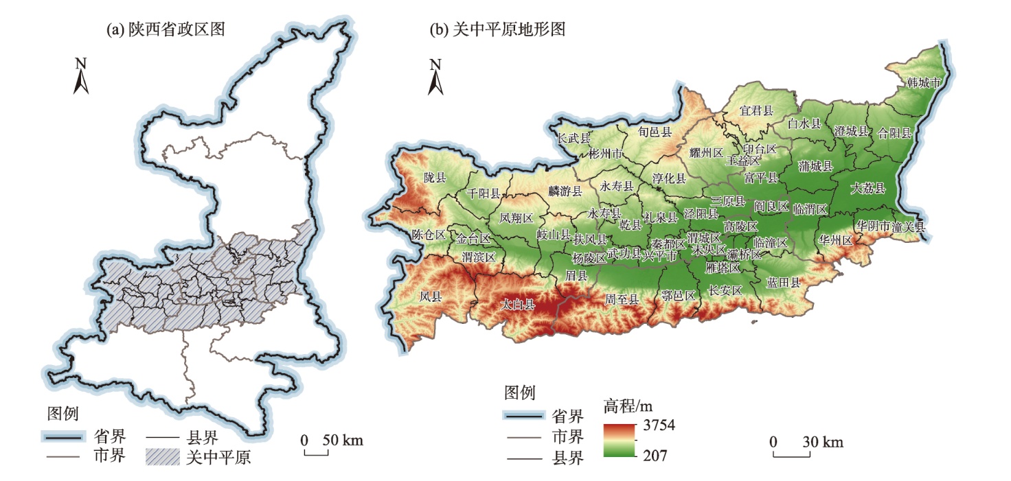
王建兴. 陕西省粮食生产变化及原因分析[J]. 新西部(理论版), 2015(23): 26-27.
|
|
[Wang Jianxing. Analysis of grain production changes and driving factors in Shaanxi Province[J]. New West, 2015(23): 26-27.]
|
| [23] |
崔许锋, 王雨菲, 张光宏. 面向低碳发展的农业生态效率测度与时空演变分析——基于SBM-ESDA模型[J]. 农业经济问题, 2022(9): 47-61.
|
|
[Cui Xufeng, Wang Yufei, Zhang Guanghong. Low-carbon oriented measurement and spatiotemporal evolution of agricultural eco-efficiency in China: Based on SBM-ESDA model[J]. Issues in Agricultural Economy, 2022(9): 47-61.]
|
| [24] |
李松芮, 林秋平, 杨上广. 新疆物流企业空间布局多尺度演化特征及影响因素研究[J]. 干旱区地理, 2025, 48(4): 739-752.
doi: 10.12118/j.issn.1000-6060.2024.404
|
|
[Li Songrui, Liu Qiuping, Yang Shangguang. Multi-scale evolution characteristics and influencing factors of spatial layout of logistics enterprises in Xinjiang[J]. Arid Land Geography, 2025, 48(4): 739-752.]
doi: 10.12118/j.issn.1000-6060.2024.404
|
| [25] |
侯彩霞, 张宇宙, 杨建平. 关中平原城市群水资源-社会-生态系统耦合协调及障碍因子分析[J]. 干旱区地理, 2025, 48(4): 717-727.
doi: 10.12118/j.issn.1000-6060.2024.280
|
|
[Hou Caixia, Zhang Yuzhou, Yang Jianping. Coupling coordination and obstacle factors of water-society-ecosystem in the Guanzhong Plain urban agglomeration[J]. Arid Land Geography, 2025, 48(4): 717-727.]
doi: 10.12118/j.issn.1000-6060.2024.280
|
| [26] |
张婕, 孙洁, 朱明明. 渭河流域生态补偿政策效果评估研究[J]. 资源与产业, 2022, 24(2): 64-75.
|
|
[Zhang Jie, Sun Jie, Zhu Mingming. Policy effects evaluation of ecological compensation of Wei River stream[J]. Resources & Industries, 2022, 24(2): 64-75.]
|
 )
)