干旱区地理 ›› 2026, Vol. 49 ›› Issue (3): 534-548.doi: 10.12118/j.issn.1000-6060.2025.137 cstr: 32274.14.ALG2025137
李明轩1( ), 类冬雪1, 丁国栋1,2,3,4(), 王瀚卓1
收稿日期:2025-03-11
修回日期:2025-11-13
出版日期:2026-03-25
发布日期:2026-03-24
通讯作者:
丁国栋(1963-),男,博士,教授,主要从事水土保持与荒漠化防治研究. E-mail: dch1999@263.net作者简介:李明轩(2000-),女,硕士研究生,主要从事水土保持与荒漠化防治研究. E-mail: cattleyal118@163.com
基金资助:
LI Mingxuan1(), LEI Dongxue1, DING Guodong1,2,3,4(), WANG Hanzhuo1
Received:2025-03-11
Revised:2025-11-13
Published:2026-03-25
Online:2026-03-24
摘要:
内蒙古哈腾套海国家级自然保护区属于典型荒漠向草原化荒漠的过渡带,是内蒙古西部重要的荒漠生态系统。30多年以来,保护区植被状况发生了显著变化,因此系统地分析保护区植被分布格局具有巨大意义。采用野外调查和遥感图像解译相结合的方法,深入分析2000—2023年保护区植被变化特征与群落组成现状。结果表明:(1)保护区植被覆盖度(FVC)以0.0027·a-1的速率增长,且呈现“西低、东高”格局,植被格局总体稳定,但总体健康状态堪忧。(2)保护区内共有高等植物47科135属199种,其中保护植物6种、入侵植物2种,植物区系组成以温带分布类型为主。植被可划分为11个群系,隶属5个植被型,以西部山区广泛分布的旱生灌木群系为优势类型。调查研究表明,当前植物多样性呈下降趋势,部分保护植物已消失,但发现了蒺藜草(Cenchrus echinatus)和圆叶牵牛(Ipomoea purpurea)2种入侵植物;尽管群系类型较为丰富,但整体结构较为简单。(3)蒸散发和高程是影响FVC和植被群系分布的最主要驱动因子,近年来,人为干扰的影响显著减弱,反映出生态保护政策的实施已取得一定成效。
李明轩, 类冬雪, 丁国栋, 王瀚卓. 内蒙古哈腾套海国家级自然保护区植被变化特征与群落组成现状[J]. 干旱区地理, 2026, 49(3): 534-548.
LI Mingxuan, LEI Dongxue, DING Guodong, WANG Hanzhuo. Characteristics of vegetation change and current status of community composition in the Hatengtaohai National Nature Reserve, Inner Mongolia[J]. Arid Land Geography, 2026, 49(3): 534-548.
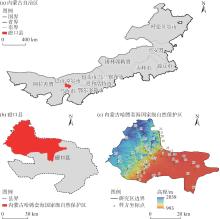
图1
研究区位置 注:基于内蒙古自治区标准地图服务网站审图号为蒙S(2017)029号的标准地图制作,底图边界无修改。下同。"

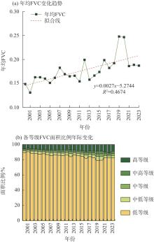
图2
2000—2023年哈腾套海国家级自然保护区植被覆盖度(FVC)时间变化特征"
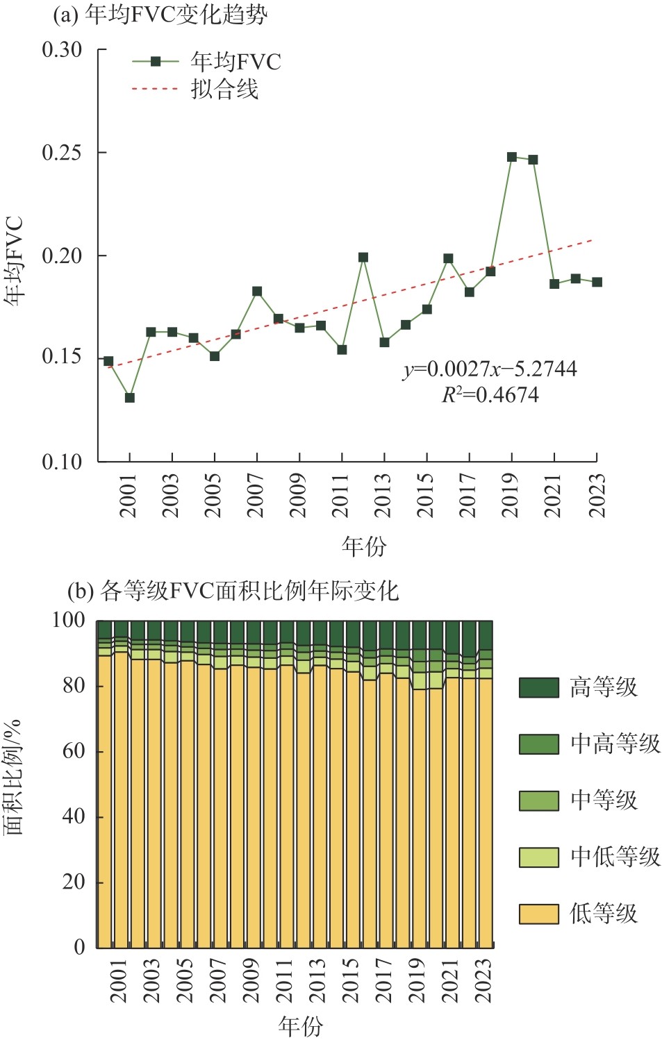
表1
植被覆盖度(FVC)等级划分"
| 年均FVC取值范围 | FVC等级 |
|---|---|
| 0.00~0.30 | 低等级 |
| 0.30~0.45 | 中低等级 |
| 0.45~0.60 | 中等级 |
| 0.60~0.75 | 中高等级 |
| 0.75~1.00 | 高等级 |
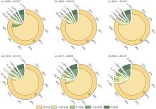
图3
2000—2023年哈腾套海国家级自然保护区各等级FVC转化面积占比"
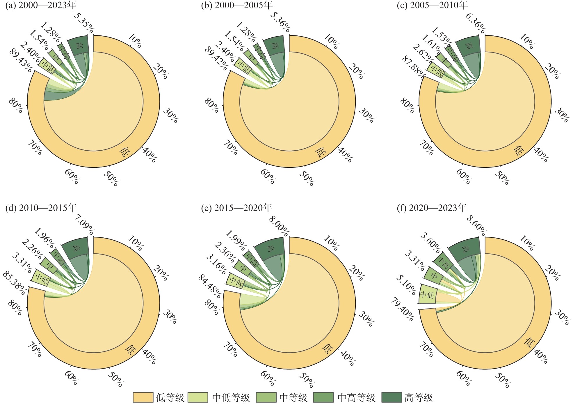
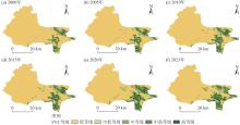
图4
2000—2023年哈腾套海国家级自然保护区不同等级FVC空间分布"

图5
2000—2023年哈腾套海国家级自然保护区不同等级FVC重心迁移"
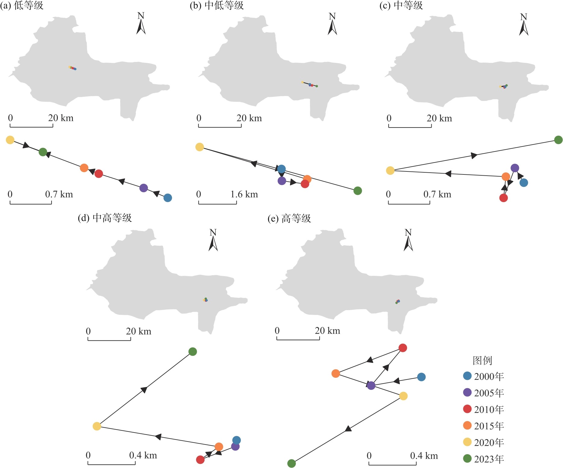
表2
哈腾套海国家级自然保护区种子植物统计与内蒙古及全国比较"
| 分类群 | 哈腾套海国家级自然保护区 | 内蒙古 | 全国 | ||||||||
|---|---|---|---|---|---|---|---|---|---|---|---|
| 科数 | 属数 | 种数 | 科数 | 属数 | 种数 | 科数 | 属数 | 种数 | |||
| 裸子植物 | 3 | 3 | 4 | 4 | 8 | 28 | 10 | 44 | 250 | ||
| 被子植物 | 43 | 131 | 194 | 127 | 706 | 2550 | 265 | 3040 | 30000 | ||
| 蕨类 | 1 | 1 | 1 | 13 | 23 | 41 | 36 | 156 | 2500 | ||
| 总计 | 47 | 135 | 199 | 144 | 737 | 2619 | 311 | 3240 | 32750 | ||
表3
哈腾套海国家级自然保护区高等植物科组成"
| 科含种数(科数) | 科(属数/种数) |
|---|---|
| ≥20(3) | 菊科(19/31)、豆科(14/23)、苋科(13/23) |
| 10~19(2) | 禾本科(17/18)、蔷薇科(7/14) |
| 2~9(20) | 蓼科(4/7)、十字花科(4/6)、唇形科(4/4)、石竹科(3/4)、茄科(3/3)、杨柳科(2/7)、毛莨科(2/4)、旋花科(2/4)、白刺科(2/3)、车前科(2/3)、柽柳科(2/3)、紫草科(2/3)、蒺藜科(2/2)、木犀科(2/2)、伞形科(2/2)、榆科(1/3)、夹竹桃科(1/2)、莎草科(1/2)、石蒜科(1/2)、松科(1/2) |
| 1(22) | 白花丹科(1/1)、柏科(1/1)、报春花科(1/1)、大戟科(1/1)、胡颓子科(1/1)、锦葵科(1/1)、列当科(1/1)、麻黄科(1/1)、马齿苋科(1/1)、牻牛儿苗(1/1)、木贼科(1/1)、葡萄科(1/1)、漆树科(1/1)、鼠李科(1/1)、粟米草科(1/1)、天门冬科(1/1)、通泉草科(1/1)、卫矛科(1/1)、罂粟科(1/1)、远志科(1/1)、芸香科(1/1)、鸢尾科(1/1) |
表4
哈腾套海国家级自然保护区植物科、属和种的分布区类型"
| 分布区类型及其变型 | 科 | 属 | 种 | |||||
|---|---|---|---|---|---|---|---|---|
| 数量 | 占比/% | 数量 | 占比/% | 数量 | 占比/% | |||
| 1. 广布(世界广布) | 21 | 46.81 | 24 | 17.78 | 40 | 20.10 | ||
| 2. 泛热带(热带广布)分布 | 9 | 19.15 | 16 | 11.85 | 18 | 9.05 | ||
| 2-1. 热带亚洲-大洋洲和热带美洲(南美洲或和墨西哥)分布 | 0 | 0.00 | 1 | 0.74 | 1 | 0.50 | ||
| 2-2. 热带亚洲、非洲和南美洲间断分布 | 2 | 4.26 | 0 | 0.00 | 0 | 0.00 | ||
| 2S. 以南半球为主的泛热带分布 | 2 | 4.26 | 0 | 0.00 | 0 | 0.00 | ||
| 3. 热带亚洲和热带美洲间断分布 | 0 | 0.00 | 0 | 0.00 | 0 | 0.00 | ||
| 4. 旧日世界热带分布 | 1 | 2.13 | 1 | 0.74 | 1 | 0.50 | ||
| 5. 热带亚洲至热带大洋洲分布 | 0 | 0.00 | 0 | 0.00 | 0 | 0.00 | ||
| 6. 热带亚洲至热带非洲分布 | 0 | 0.00 | 1 | 0.74 | 1 | 0.50 | ||
| 7. 热带亚洲(印度-马来西亚)分布 | 0 | 0.00 | 1 | 0.74 | 2 | 1.01 | ||
| 8. 北温带分布 | 2 | 4.26 | 26 | 19.26 | 53 | 26.63 | ||
| 8-4. 北温带和南温带(全温带)间断分布 | 5 | 10.64 | 3 | 2.22 | 4 | 2.01 | ||
| 8-5. 欧亚和南美洲温带间断分布 | 0 | 0.00 | 1 | 0.74 | 1 | 0.50 | ||
| 9. 东亚和北美洲间断分布 | 0 | 0.00 | 5 | 3.70 | 6 | 3.02 | ||
| 10. 旧世界温带分布 | 1 | 2.13 | 11 | 8.15 | 12 | 6.03 | ||
| 10-1. 地中海区至西亚(或中亚)和东亚间断分布 | 0 | 0.00 | 4 | 2.96 | 11 | 5.53 | ||
| 10-3. 欧亚和南非(有时也在澳大利亚)分布 | 0 | 0.00 | 2 | 1.48 | 2 | 1.01 | ||
| 11. 温带亚洲分布 | 0 | 0.00 | 7 | 5.19 | 10 | 5.03 | ||
| 12. 地中海区、西亚至中亚分布 | 0 | 0.00 | 13 | 9.63 | 15 | 7.54 | ||
| 12-1. 地中海区至中亚和南非洲和/或大洋洲间断分布 | 0 | 0.00 | 1 | 0.74 | 1 | 0.50 | ||
| 12-2. 地中海区至西亚或中亚和墨西哥或古巴间断分布 | 0 | 0.00 | 2 | 1.48 | 3 | 1.51 | ||
| 12-3. 地中海区至温带-热带亚洲、大洋洲和/或北美南部至南美洲间断分布 | 2 | 4.26 | 2 | 1.48 | 2 | 1.01 | ||
| 12-4. 地中海区至热带、非洲和喜马拉雅山间断分布 | 0 | 0.00 | 1 | 0.74 | 2 | 1.01 | ||
| 13. 中亚分布 | 0 | 0.00 | 2 | 1.48 | 3 | 1.51 | ||
| 13-1. 中亚东部分布 | 0 | 0.00 | 5 | 3.70 | 5 | 2.51 | ||
| 13-2. 中亚东部至喜马拉雅和中国西南部分布 | 1 | 2.13 | 0 | 0.00 | 0 | 0.00 | ||
| 14. 东亚分布 | 0 | 0.00 | 3 | 2.22 | 3 | 1.51 | ||
| 14-1. 中国-喜马拉雅分布 | 0 | 0.00 | 1 | 0.74 | 1 | 0.50 | ||
| 14-2. 中国-日本分布 | 0 | 0.00 | 2 | 1.48 | 2 | 1.01 | ||
| 15. 中国特有分布 | 0 | 0.00 | 0 | 0.00 | 0 | 0.00 | ||
| 合计 | 47 | 100.00 | 135 | 100.00 | 199 | 100.00 | ||
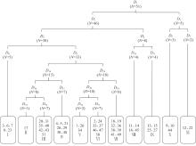
图6
哈腾套海国家级自然保护区群系双向指示种分析(TWINSPAN)分类树状图 注:N为样方数;Dk(k=1~77)为第k次分类;阿拉伯数字1~51为样方编号;罗马数字Ⅰ~Ⅺ为对应的植物群系。"

表5
哈腾套海国家级自然保护区植被群系类型"
| 序号 | 植被群系类型 | 优势种 重要值/% | Shannon- Wiener指数 | Simpson 指数 | Pielou 指数 |
|---|---|---|---|---|---|
| Ⅰ | 柠条锦鸡儿群系 | 56.19 | 1.64 | 0.72 | 0.66 |
| Ⅱ | 梭梭群系 | 74.23 | 1.50 | 0.75 | 0.83 |
| Ⅲ | 蒙古扁桃群系 | 27.87 | 2.12 | 0.85 | 0.77 |
| Ⅳ | 猫头刺-霸王群系 | 22.73 | 1.64 | 0.72 | 0.66 |
| Ⅴ | 沙冬青群系 | 45.47 | 0.85 | 0.43 | 0.53 |
| Ⅵ | 霸王群系 | 37.15 | 2.01 | 0.81 | 0.74 |
| Ⅶ | 红砂群系 | 30.26 | 1.41 | 0.64 | 0.54 |
| Ⅷ | 芦苇群系 | 65.82 | 0.46 | 0.26 | 0.42 |
| Ⅸ | 柽柳群系 | 28.00 | 0.07 | 0.03 | 0.05 |
| Ⅹ | 唐古特白刺群系 | 34.24 | 1.39 | 0.76 | 0.67 |
| Ⅺ | 沙蓬-蒙古虫实群系 | 32.08 | 0.60 | 0.41 | 0.86 |
| 均值 | - | 1.24 | 0.58 | 0.61 |

图7
哈腾套海国家级自然保护区群系分布 注:叠加斜线区域为2个及以上对应颜色所指代群系过渡区。"
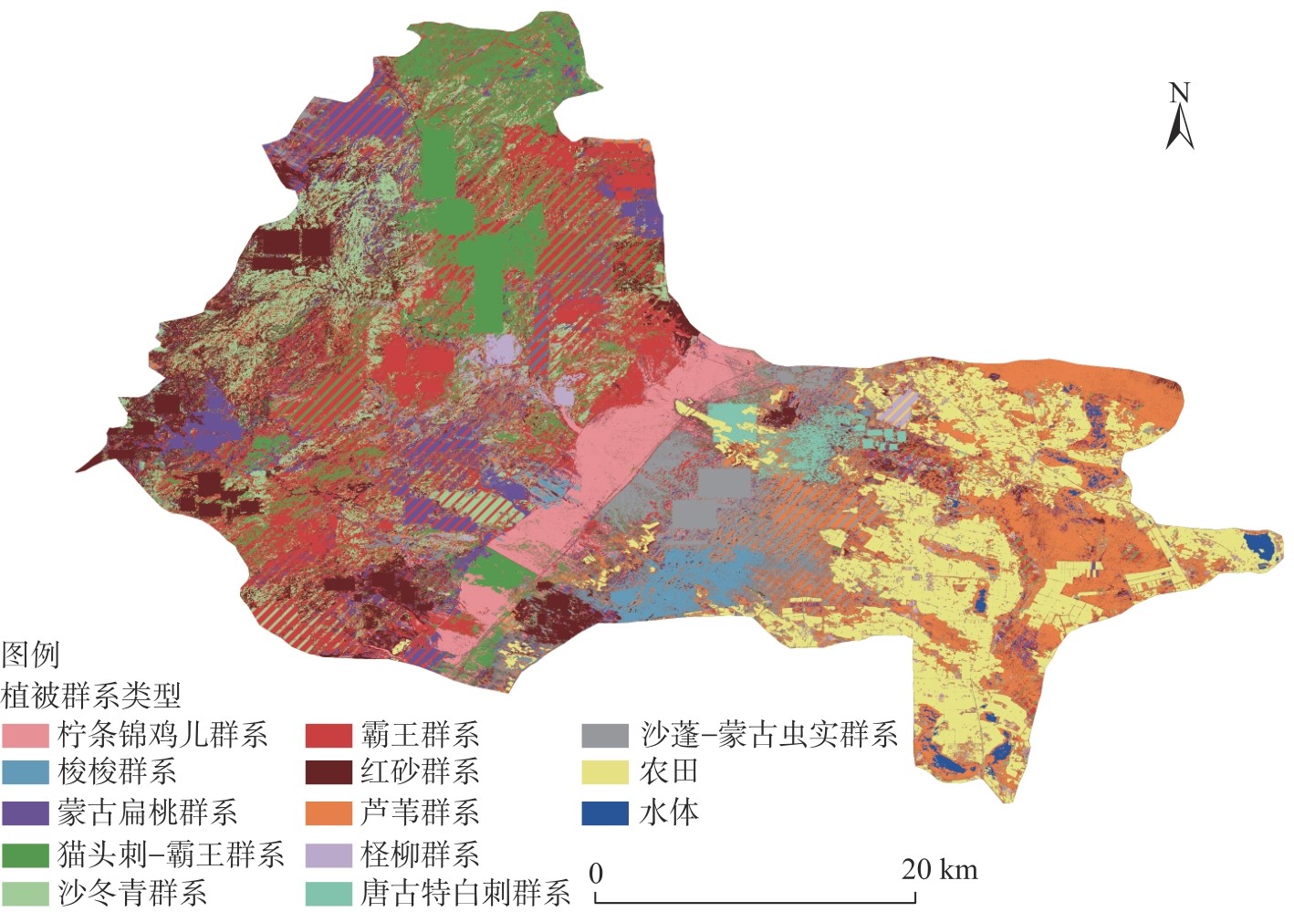
表6
哈腾套海国家级自然保护区群系分布面积"
| 序号 | 植被群系类型 | 面积/hm2 | 序号 | 植被群系类型 | 面积/hm2 |
|---|---|---|---|---|---|
| Ⅰ | 柠条锦鸡儿群系 | 6060.28 | Ⅶ | 红砂群系 | 22520.75 |
| Ⅱ | 梭梭群系 | 3463.63 | Ⅷ | 芦苇群系 | 12965.50 |
| Ⅲ | 蒙古扁桃群系 | 12587.88 | Ⅸ | 柽柳群系 | 2979.25 |
| Ⅳ | 猫头刺-霸王群系 | 21298.50 | Ⅹ | 唐古特白刺群系 | 1116.00 |
| Ⅴ | 沙冬青群系 | 2258.10 | Ⅺ | 沙蓬-蒙古虫实群系 | 4661.12 |
| Ⅵ | 霸王群系 | 30945.72 |
表7
驱动因子含义"
| 因素 | 因子 | 因子含义 |
|---|---|---|
| 地理因素 | 高程(X1)/m | 保护区海拔高度 |
| 地貌类型(X2) | 保护区地貌类型 | |
| 气候因素 | 地表温度(X3)/℃ | 保护区年均地表温度 |
| 降水量(X4)/mm | 保护区年降水量 | |
| 蒸散发(X5)/mm | 保护区年蒸散发量 | |
| 人为因素 | 道路欧氏距离(X6)/km | 保护区内与道路距离 |
图8
FVC因子探测结果 注:X1为高程;X2为地貌类型;X3为地表温度;X4为降水量;X5为蒸散发;X6为道路欧式距离;q值为该因子对空间分异的解释力。下同。"
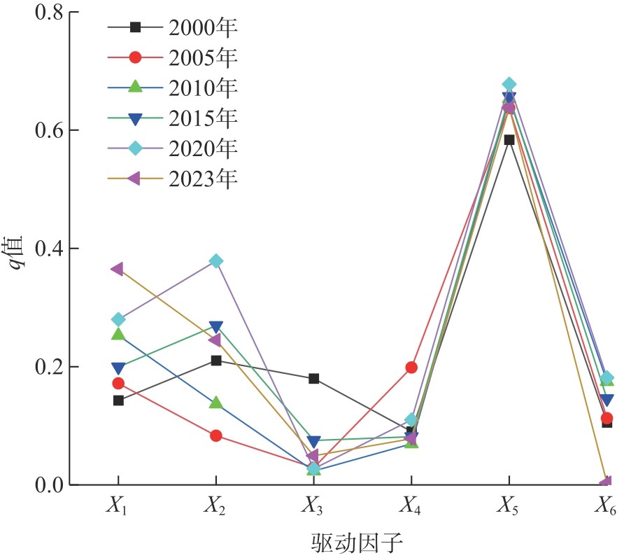
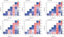
图9
FVC交互探测结果"
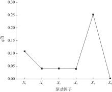
图10
植被群落分布因子探测结果"

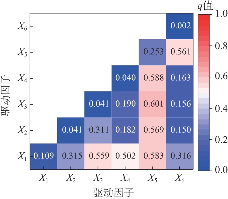
图11
植被群落分布交互探测结果"
| [1] |
赵东颖, 蒙仲举, 孟芮冰, 等. 乌兰布和沙漠风沙入黄段植被覆盖动态变化特征及驱动力[J]. 干旱区研究, 2024, 41(4): 639-649.
doi: 10.13866/j.azr.2024.04.10 |
|
[Zhao Dongying, Meng Zhongju, Meng Ruibing, et al. Dynamic change characteristics and driving forces of vegetation cover in the Ulan Buhe Desert along the Yellow River[J]. Arid Zone Research, 2024, 41(4): 639-649.]
doi: 10.13866/j.azr.2024.04.10 |
|
| [2] |
杨育林, 黄兰鹰, 杨勇智, 等. 理塘格木自然保护区野生种子植物区系调查分析[J]. 安徽农学通报, 2025, 31(2): 92-96.
doi: 10.16377/j.cnki.issn1007-7731.2025.02.017 |
|
[Yang Yulin, Huang Lanying, Yang Yongzhi, et al. Investigation and analysis of wild seed plant flora in Litang Gemu Nature Reserve[J]. Anhui Agricultural Science Bulletin, 2025, 31(2): 92-96.]
doi: 10.16377/j.cnki.issn1007-7731.2025.02.017 |
|
| [3] |
李千飞, 沈艳, 马红彬, 等. 宁夏罗山山地草原植物群落数量分类与生物多样性特征[J]. 应用生态学报, 2024, 35(10): 2697-2706.
doi: 10.13287/j.1001-9332.202410.004 |
|
[Li Qianfei, Shen Yan, Ma Hongbin, et al. Quantitative classification and biodiversity characteristics of plant communities in Luoshan Mountain steppe, China[J]. Chinese Journal of Applied Ecology, 2024, 35(10): 2697-2706.]
doi: 10.13287/j.1001-9332.202410.004 |
|
| [4] | 周姗姗, 袁祖林, 席首刚, 等. 甘肃皋兰县荒漠草原植物群落数量分类及植被特征研究[J]. 草原与草坪, 2024, 44(5): 51-60. |
| [Zhou Shanshan, Yuan Zulin, Xi Shougang, et al. Quantitative classification and vegetation characteristics of plant communities of desert steppe in Gaolan County[J]. Grassland and Turf, 2024, 44(5): 51-60.] | |
| [5] | 杨星, 方乐缘, 岳俊. 高光谱遥感影像半监督分类研究进展[J]. 遥感学报, 2024, 28(1): 20-41. |
|
[Yang Xing, Fang Leyuan, Yue Jun. Advances in semi-supervised classification of hyperspectral remote sensing images[J]. National Remote Sensing Bulletin, 2024, 28(1): 20-41.]
doi: 10.11834/jrs.20243404 |
|
| [6] | 召那. 灌木林资源资产评估研究[D]. 呼和浩特: 内蒙古农业大学, 2011. |
| [Zhao Na. Evaluation research on shrubs resources[D]. Huhhot: Inner Mongolia Agricultural University, 2011.] | |
| [7] | 马莉. 基于利益相关者博弈的荒漠化地区生态补偿估算研究[D]. 北京: 北京林业大学, 2021. |
| [Mali. Study on estimation of ecological compensation in desertification area based on stakeholders game[D]. Beijing: Beijing Forestry University, 2021.] | |
| [8] | 张建波. 内蒙古哈腾套海国家级自然保护区夏季岩羊分布与数量调查[J]. 内蒙古林业调查设计, 2022, 45(4): 67-69. |
| [Zhang Jianbo. Investigation on distribution and quantity of rock sheep in summer in Hatengtaohai National Nature Reserve of Inner Mongolia[J]. Inner Mongolia Forestry Investigation and Design, 2022, 45(4): 67-69.] | |
| [9] | 吉木斯. 哈腾套海国家级自然保护区野生动物区系调查研究[J]. 绿色科技, 2010(9): 121-124. |
| [Ji Musi. Neimenggu Hatengtaohai National Nature Reserve set fauna of wild animals[J]. Journal of Green Science and Technology, 2010(9): 121-124.] | |
| [10] | 董佳奇, 杨制国, 许宏斌, 等. 基于AHP-GIS的乌兰布和沙漠地区生态敏感性分析与评价[J]. 内蒙古林业科技, 2025, 51(2): 26-32. |
| [Dong Jiaqi, Yang Zhiguo, Xu Hongbin, et al. Analysis and evaluation of ecological sensitivity in the Ulan Buh Desert based on AHP-GIS[J]. Journal of Inner Mongolia Forestry Science & Technology, 2025, 51(2): 26-32.] | |
| [11] | 韩二牛. 哈腾套海国家级自然保护区[J]. 内蒙古林业, 2006(3): 45. |
| [Han Erniu. Hatengtaohai National Nature Reserve[J]. Inner Mongolia Forestry, 2006(3): 45.] | |
| [12] | 巴彦淖尔市林业和草原局. 内蒙古哈腾套海国家级自然保护区总体规划(2022—2031年)[EB/OL]. [2024-12-20]. http://lcj.bynr.gov.cn/tzgg/202207/t20220712_436815.html. |
| [Bayannur City Forestry and Grassland Administration. Overall plan of the Inner Mongolia Hatengtaohai National Nature Reserve (2022—2031)[EB/OL]. [2024-12-20]. http://lcj.bynr.gov.cn/tzgg/202207/t20220712_436815.html.] | |
| [13] |
曹昱轩, 李锦荣, 杨旭, 等. 乌兰布和沙漠植被因子对风沙活动特征的影响[J]. 中国沙漠, 2025, 45(2): 37-46.
doi: 10.7522/j.issn.1000-694X.2024.00140 |
|
[Cao Yuxuan, Li Jinrong, Yang Xu, et al. The impact of vegetation factors of three vegetation communities on aeolian sand factors in the Ulan Buh Desert[J]. Journal of Desert Research, 2025, 45(2): 37-46.]
doi: 10.7522/j.issn.1000-694X.2024.00140 |
|
| [14] |
甘开元, 张金霞, 陈丽娟, 等. 乌兰布和沙漠沿黄河段植物群落特征及空间分异[J]. 中国沙漠, 2023, 43(4): 180-190.
doi: 10.7522/j.issn.1000-694X.2023.00040 |
|
[Gan Kaiyuan, Zhang Jinxia, Chen Lijuan, et al. Characteristics and spatial differentiation of plant communities along the Yellow River in the Ulan Buh Desert[J]. Journal of Desert Research, 2023, 43(4): 180-190.]
doi: 10.7522/j.issn.1000-694X.2023.00040 |
|
| [15] | Yang J L, Dong J W, Xiao X M, et al. Divergent shifts in peak photosynthesis timing of temperate and alpine grasslands in China[J]. Remote Sensing of Environment, 2019, 233: 111395, doi: 10.1016/j.rse.2019.111395. |
| [16] | 李苗苗, 吴炳方, 颜长珍, 等. 密云水库上游植被覆盖度的遥感估算[J]. 资源科学, 2004(4): 153-159. |
| [Li Miaomiao, Wu Bingfang, Yan Changzhen, et al. Estimation of vegetation fraction in the upper basin of Miyun reservoir by remote sensing[J]. Resources Science, 2004(4): 153-159.] | |
| [17] | 刘静, 温仲明, 刚成诚. 黄土高原不同植被覆被类型NDVI对气候变化的响应[J]. 生态学报, 2020, 40(2): 678-691. |
| [Liu Jing, Wen Zhongming, Gang Chengcheng. Normalized difference vegetation index of different vegetation cover types and its responses to climate change in the Loess Plateau[J]. Acta Ecologica Sinica, 2020, 40(2): 678-691.] | |
| [18] | 刘伟, 向莹, 李景吉, 等. 2000—2020年四川省泸沽湖湿地自然保护区陆地植被覆盖动态变化[J]. 水土保持通报, 2023, 43(5): 203-211, 278. |
| [Liu Wei, Xiang Ying, Li Jingji, et al. Dynamic changes of terrestrial vegetation cover in Lugu Lake Wetland Nature Reserve, Sichuan Province from 2000 to 2020[J]. Bulletin of Soil and Water Conservation, 2023, 43(5): 203-211, 278.] | |
| [19] | 韩新星, 艾金泉, 叶子君, 等. 基于遥感云计算的鄱阳湖湿地植被群落分类研究[J]. 人民长江, 2023, 54(7): 55-60. |
| [Han Xinxing, Ai Jinquan, Ye Zijun, et al. Classification of wetland vegetation community in Poyang Lake based on remote sensing cloud computing[J]. Yangtze River, 2023, 54(7): 55-60.] | |
| [20] |
宋小龙, 李陇堂, 任婕, 等. 西北干旱生态地理区NDVI时空变化特征及其驱动力[J]. 干旱区地理, 2025, 48(6): 951-962.
doi: 10.12118/j.issn.1000-6060.2024.548 |
|
[Song Xiaolong, Li Longtang, Ren Jie, et al. Spatio-temporal variation characteristics and driving factors of NDVI in the arid and semi-arid region of northwest China[J]. Arid Land Geography, 2025, 48(6): 951-962.]
doi: 10.12118/j.issn.1000-6060.2024.548 |
|
| [21] | 龚静, 彭培好. 四川秦巴山区植被覆盖变化及其影响因素分析[J]. 四川林业科技, 2024, 45(5): 20-28. |
| [Gong Jing, Peng Peihao. Analysis of vegetation cover change and its influencing factors of Qinba Mountains in Sichuan Province[J]. Journal of Sichuan Forestry Science and Technology, 2024, 45(5): 20-28.] | |
| [22] | 王志军, 于海云, 杨旭, 等. 乌兰布和沙漠植被覆盖度变化研究[J]. 内蒙古水利, 2024(8): 91-93. |
| [Wang Zhijun, Yu Haiyun, Yang Xu, et al. Research on changes in vegetation coverage of the Ulan Buh Desert[J]. Inner Mongolia Water Resources, 2024(8): 91-93.] | |
| [23] | 刘艳琦. 乌兰布和沙漠生态环境要素时空演变与生态脆弱性研究[D]. 呼和浩特: 内蒙古农业大学, 2022. |
| [Liu Yanqi. Spatial-temporal evolution and ecological vulnerability of ecological environmental factors in Ulan Buh Desert[D]. Huhhot: Inner Mongolia Agricultural University, 2022.] | |
| [24] | 贾沼霖, 贺帅奇, 李新义, 等. 磴口县乌兰布和沙漠地区治理现状调研[J]. 海河水利, 2022(增刊1): 35-39. |
| [Jia Zhaolin, He Shuaiqi, Li Xinyi, et al. Investigation on the governance status of Ulanbuh Desert area in Dengkou County[J]. Haihe Water Resources, 2022(Suppl. 1): 35-39.] | |
| [25] | 于亮亮. 基于高分与Landsat卫星的磴口县林地面积变化监测[J]. 现代农业, 2016(11): 90-92. |
| [Yu Liangliang. Monitoring forest area changes in Dengkou County based on Gaofen and Landsat satellite imagery[J]. Modern Agriculture, 2016(11): 90-92.] | |
| [26] | 田文坦, 刘扬, 王树彦, 等. 内蒙古外来入侵物种及其对草原的影响[J]. 草业科学, 2015, 32(11): 1781-1788. |
| [Tian Wentan, Liu Yang, Wang Shuyan, et al. Alien invasive species in Inner Mongolia and their influence on the grassland[J]. Pratacultural Science, 2015, 32(11): 1781-1788.] | |
| [27] | 邓丰志. 圆叶牵牛(Ipomoea purpurea)种子生物学、幼苗抗逆性和化学防除技术研究[D]. 哈尔滨: 东北农业大学, 2023. |
| [Deng Fengzhi. Study on seed biology, seedling stress resistance and chemical control technology of Ipomoea purpurea[D]. Harbin: Northeast Agricultural University, 2023.] | |
| [28] | 辛智鸣, 邵琪雯, 王湘, 等. 乌兰布和沙漠植物多样性及绿洲-荒漠区植被地上生物量研究[J]. 生态学报, 2024, 44(18): 8234-8246. |
| [Xin Zhiming, Shao Qiwen, Wang Xiang, et al. Plant diversity and aboveground biomass of oasis-desert vegetation in Ulan Buhe Desert[J]. Acta Ecological Sinica, 2024, 44(18): 8234-8246.] | |
| [29] | 赵力兴, 徐兴健, 其格其, 等. 大兴安岭南段不同退化程度草甸草原植物群落结构与物种多样性[J]. 草原与草坪, 2024, 44(5): 106-114. |
| [Zhao Lixing, Xu Xingjian, Qigeqi, et al. Plant community structure and species diversity in degraded meadow steppes at the southern foot of the Greater Xing’an Mountains[J]. Grassland and Turf, 2024, 44(5): 106-114.] | |
| [30] | 李晓兰, 李雪华, 蒋德明, 等. 科尔沁沙地22种菊科草本植物叶片形态特征研究[J]. 生态学杂志, 2005, 24(12): 1397-1401. |
| [Li Xiaolan, Li Xuehua, Jiang Deming, et al. Leaf morphological characters of 22 compositae herbaceous species in Horqin Sandy Land[J]. Chinese Journal of Ecology, 2005, 24(12): 1397-1401.] | |
| [31] | 贾鲜艳, 吴宏宇, 李霞, 等. 河套灌区盐碱地植物种类组成研究[J]. 内蒙古农业大学学报, 2006, 27(4): 78-82. |
| [Jia Xianyan, Wu Hongyu, Li Xia, et al. Study on floristics component of saline: Alkaliland in Hetao Irrigation Region[J]. Journal of Inner Mongolia Agricultural University, 2006, 27(4): 78-82.] | |
| [32] | 贾鹏. 基于遥感的磴口县土地利用/覆盖变化研究[D]. 兰州: 兰州大学, 2016. |
| [Jia Peng. Analysis of land use/land cover change of Deng Kou based on remote sensing[D]. Lanzhou: Lanzhou University, 2016.] | |
| [33] | 萨仁, 马秀珍. 磴口县生态脆弱区脆弱性原因分析[J]. 西部资源, 2018(6): 113-115. |
| [Saren, Ma Xiuzhen. Analysis of the causes of ecological vulnerability in the fragile areas of Dengkou County[J]. Western Resources, 2018(6): 113-115.] |
| [1] | 王安琪, 张钰, 刘佳伟, 赵威, 刘馨雨, 李凯. 新疆甘家湖梭梭林国家级自然保护区植被群落多样性及空间分布格局[J]. 干旱区地理, 2024, 47(11): 1841-1851. |
| [2] | 陈淑君,许国昌,吕志平,马铭悦,李晗羽,朱玉岩. 中国植被覆盖度时空演变及其对气候变化和城市化的响应[J]. 干旱区地理, 2023, 46(5): 742-752. |
| [3] | 郭方君, 马全林, 张锦春, 李得禄, 袁宏波, 陈芳, 魏林源, 张德魁. 石羊河流域荒漠区植被类型、分布和数量特征[J]. 干旱区地理, 2023, 46(11): 1848-1857. |
| [4] | 王振, 李均力, 张久丹, 吴浩儒, 郭雪飞. 输水漫溢对塔里木河中游胡杨林恢复的影响[J]. 干旱区地理, 2023, 46(1): 94-102. |
| [5] | 张久丹, 李均力, 包安明, 白洁, 刘铁, 黄粤. 2013—2020年塔里木河流域胡杨林生态恢复成效评估[J]. 干旱区地理, 2022, 45(6): 1824-1835. |
| [6] | 刘玉婷,张齐飞,刘景时,关含笑,孟凡雪. 近20 a新疆南部植被覆盖度时空特征及对气候因素的响应——以塔什库尔干塔吉克自治县为例[J]. 干旱区地理, 2022, 45(5): 1481-1489. |
| [7] | 白慧,尹丽颖,苏辉明,高峰,穆玉琴,张芸芸,童玉平,徐文轩,,曹秋梅,,杨维康,,徐峰. 利用红外相机监测新疆天池博格达峰自然保护区鸟兽资源[J]. 干旱区地理, 2022, 45(3): 847-859. |
| [8] | 马剑,刘贤德,何晓玲,王顺利,贺永岩,武秀荣,赵晶忠,马雪娥. 祁连山典型灌丛群落结构特征及其多样性研究[J]. 干旱区地理, 2021, 44(5): 1427-1437. |
| [9] | 李玉朋,陈亚宁,叶朝霞,王非,孙帆,秦景秀. 塔里木河下游输水20 a的生态响应[J]. 干旱区地理, 2021, 44(3): 700-707. |
| [10] | 董雪, 李永华, 辛智鸣, 段瑞兵, 姚斌, 包岩峰, 黄雅茹, 张正国 . 河西走廊西段戈壁灌木群落多样性及其分布格局研究[J]. 干旱区地理, 2020, 43(6): 1514-1522. |
| [11] | 岳健, 穆桂金, 唐自华, 杨雪峰, 林永崇, 徐立帅. 基于NDVI的新疆荒漠地区植被覆盖度遥感估算经验模型研究[J]. 干旱区地理, 2020, 43(1): 153-160. |
| [12] | 张斯琦, 陈辉, 宋明华, 付阳, 牛慧慧, 杨祎, 张博雄. 2000—2015年柴达木盆地植被覆盖度时空变化及其与环境因子的关系[J]. 干旱区地理, 2019, 42(5): 1124-1132. |
| [13] | 许 佳, 祝晓瞳, 苑塏烨. 额河源流采金矿区不同恢复措施对矿区物种多样性和地上生物量的影响[J]. 干旱区地理, 2019, 42(3): 581-589. |
| [14] | 赵明伟, 王妮, 施慧慧, 江岭, 王春. 2001—2015年间我国陆地植被覆盖度时空变化及驱动力分析[J]. 干旱区地理, 2019, 42(2): 324-331. |
| [15] | 陈秀妍,付碧宏,时丕龙,郭强. 2000-2016年中亚天山植被变化及气候分异研究[J]. 干旱区地理, 2019, 42(1): 162-171. |
|
||