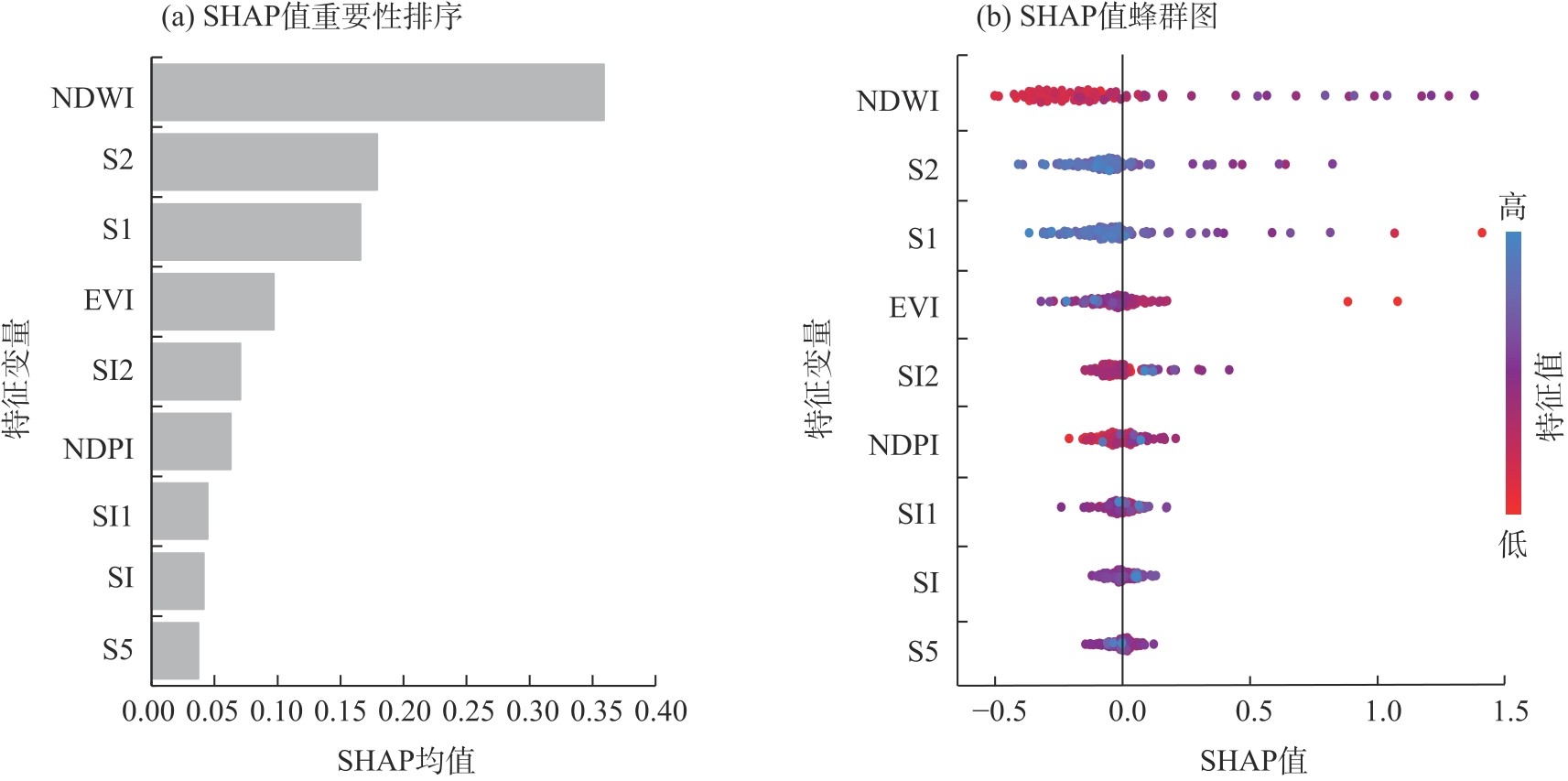
| [1] |
Butcher K, Wick A F, Desutter T, et al. Soil salinity: A threat to global food security[J]. Agronomy Journal, 2016, 108(6): 2189-2200.
doi: 10.2134/agronj2016.06.0368
|
| [2] |
李建国, 濮励杰, 朱明, 等. 土壤盐渍化研究现状及未来研究热点[J]. 地理学报, 2012, 67(9): 1233-1245.
|
|
[Li Jianguo, Pu Lijie, Zhu Ming, et al. The present situstion and hot issues in the salt-affected soil research[J]. Acta Geographica Science, 2012, 67(9): 1233-1245.]
|
| [3] |
杨劲松, 姚荣江, 王相平, 等. 中国盐渍土研究: 历程、现状与展望[J]. 土壤学报, 2022, 59(1): 10-27.
|
|
[Yang Jinsong, Yao Rongjiang, Wang Xiangping, et al. Research on salt-affected soils in China: History, status quo and prospect[J]. Acta Pedologica Science, 2022, 59(1): 10-27.]
|
| [4] |
Li J G, Pu L J, Han M F, et al. Soil salinization research in China: Advances and prospects[J]. Journal of Geographical Sciences, 2014, 24(5): 943-960.
doi: 10.1007/s11442-014-1130-2
|
| [5] |
吴秀泉, 乌兰图雅, 张萨日郎, 等. 中国干旱区草地土壤盐渍化研究可视化分析[J]. 内蒙古师范大学学报(自然科学版), 2024, 53(2): 120-128.
|
|
[Wu Xiuquan, Ulan Tuya, Zhang Saerilang, et al. Visualization analysis on grassland soil salinization in arid regions of China[J]. Journal of Inner Mongolia Normal University (Natural Science Edition), 2024, 53(2): 120-128.]
|
| [6] |
Cao C Y, Tao S, Cui Z B, et al. Response of soil properties and microbial communities to increasing salinization in the meadow grassland of northeast China[J]. Microbial Ecology, 2021, 82(3): 722-735.
doi: 10.1007/s00248-021-01695-x
pmid: 33511437
|
| [7] |
Yang L, Zhao G J, Mu X M, et al. Integrated assessments of land degradation on the Qinghai-Xizang Plateau[J]. Ecological Indicators, 2023, 147: 109945, doi: 10.1007/s00248-021-01695-x.
|
| [8] |
赵起越, 夏夜, 邹本东. 土壤盐渍化成因危害及恢复[J]. 农业与技术, 2022, 42(11): 115-119.
|
|
[Zhao Qiyue, Xia Ye, Zou Bendong. Soil salinization causes and hazards and restoration[J]. Agriculture and Technology, 2022, 42(11): 115-119.]
|
| [9] |
陈振宇, 赵禹, 白金, 等. 干旱绿洲区包气带土壤盐分分布特征及运移机制——以新疆焉耆盆地为例[J]. 地质论评, 2024, 70(5): 1857-1872.
|
|
[Chen Zhenyu, Zhao Yu, Bai Jin, et al. Distribution characteristics and migration mechanism of soil salt in the aeration zone of arid oasis areas: A case study of the Yanqi Basin, Xinjiang[J]. Geological Review, 2024, 70(5): 1857-1872.]
|
| [10] |
Metternicht G I, Zinck J A. Remote sensing of soil salinity: Potentials and constraints[J]. Remote Sensing of Environment, 2003, 85(1): 1-20.
doi: 10.1016/S0034-4257(02)00188-8
|
| [11] |
王敬哲, 丁建丽, 葛翔宇, 等. 基于星地传感技术的土壤盐渍化监测进展与展望[J]. 遥感学报, 2024, 28(9): 2187-2208.
|
|
[Wang Jingzhe, Ding Jianli, Ge Xiangyu, et al. Monitoring soil salinization on the basis of remote sensing and proximal soil sensing: Progress and prospective[J]. National Remote Sensing Bulletin, 2024, 28(9): 2187-2208.]
doi: 10.11834/jrs.20233164
|
| [12] |
Abuelgasim A, Ammad R. Mapping soil salinity in arid and semi-arid regions using Landsat 8 OLI satellite data[J]. Remote Sensing Applications, 2019, 13: 415-425.
|
| [13] |
郭佳丽, 马勇刚, 潘恒, 等. 艾比湖春夏季土壤盐渍化卫星监测对比分析[J]. 干旱区地理, 2025, 48(12): 2143-2157.
doi: 10.12118/j.issn.1000-6060.2025.044
|
|
[Guo Jiali, Ma Yonggang, Pan Heng, et al. Comparative analysis of satellite monitoring of soil salinization in Ebinur Lake during spring and summer[J]. Arid Land Geography, 2025, 48(12): 2143-2157.]
doi: 10.12118/j.issn.1000-6060.2025.044
|
| [14] |
李星佑, 张飞, 王筝. 土壤盐渍化遥感监测模型构建方法现状与发展趋势[J]. 自然资源遥感, 2022, 34(4): 11-21.
|
|
[Li Xingyou, Zhang Fei, Wang Zheng. Present situation and development trend in building remote sensing monitoring models of soil salinization[J]. Remote Sensing for Natural Resources, 2022, 34(4): 11-21.]
|
| [15] |
田义超, 郑丹琳, 张强, 等. 基于国产资源一号02D卫星和机器学习算法的钦州湾滨海土壤盐分反演[J]. 中国环境科学, 2024, 44(1): 371-385.
|
|
[Tian Yichao, Zheng Danlin, Zhang Qiang, et al. Inversion of coastal soil salinity in Qinzhou Bay based on domestic ZY1-02D satellite and machine learning algorithm[J]. China Environmental Science, 2024, 44(1): 371-385.]
|
| [16] |
Jia P P, Zhang J H, Liang Y N, et al. The inversion of arid-coastal cultivated soil salinity using explainable machine learning and Sentinel-2[J]. Ecological Indicators, 2024, 166: 112364, doi: 10.1016/j.ecolind.2024.112364.
|
| [17] |
王飞, 杨胜天, 丁建丽, 等. 环境敏感变量优选及机器学习算法预测绿洲土壤盐分[J]. 农业工程学报, 2018, 34(22): 102-110.
|
|
[Wang Fei, Yang Shengtian, Ding Jianli, et al. Environment sensitive variable optimization and machine learning algorithm using in soil salt predictionat oasis[J]. Transactions of the Chinese Society of Agricultural Engineering, 2018, 34(22): 102-110.]
|
| [18] |
巴亚岚, 张智韬, 谢坪良, 等. 集成Sentinel-1/2和环境变量的新疆农田土壤含盐量反演[J]. 农业工程学报, 2024, 40(16): 171-179.
|
|
[Ba Yalan, Zhang Zhitao, Xie Pingliang, et al. Inverting soil salinity of farmland in Xinjiang by integrating Sentinel-1/2 and environmental variables[J]. Transactions of the Chinese Society of Agricultural Engineering, 2024, 40(16): 171-179.]
|
| [19] |
骆振海, 张超, 冯绍元, 等. 土壤盐渍化光学遥感监测方法研究进展[J]. 自然资源遥感, 2024, 36(4): 9-22.
|
|
[Luo Zhenhai, Zhang Chao, Feng Shaoyuan, et al. Advances in research on methods for optical remote sensing monitoring of soil salinization[J]. Remote Sensing for Natural Resources, 2024, 36(4): 9-22.]
|
| [20] |
张佘淑, 赵军. 机器学习在土壤盐渍化遥感中应用的文献计量分析[J]. 草业科学, 2023, 40(11): 2812-2821.
|
|
[Zhang Sheshu, Zhao Jun. Bibliometric analysis of machine learning applications in remote sensing of soil salinization[J]. Pratacultural Science, 2023, 40(11): 2812-2821.]
|
| [21] |
Ponce B A V, Schmitt V, Maier C S, et al. Practical guide to SHAP analysis: Explaining supervised machine learning model predictions in drug development[J]. Clinical and Translational Science, 2024, 17(11): e70056, doi: 10.1111/cts.70056.
|
| [22] |
Wang F, Liang R L, Li S Y, et al. Assessing the impact of multi-source environmental variables on soil organic carbon in different land use types of China using an interpretable high-precision machine learning method[J]. Ecological Indicators, 2024, 169: 112865, doi: 10.1016/j.ecolind.2024.112865.
|
| [23] |
Li X H, Chen J J, Chen Z Z, et al. Explainable machine learning-based fractional vegetation cover inversion and performance optimization: A case study of an alpine grassland on the Qinghai-Tibet Plateau[J]. Ecological Informatics, 2024, 82: 102768, doi: 10.1016/j.ecoinf.2024.102768.
|
| [24] |
尚天浩, 陈睿华, 贾萍萍, 等. 基于多源光谱遥感估算银北地区土壤可溶性盐基氯离子含量[J]. 生态学杂志, 2024, 44(4): 1161-1169.
|
|
[Shang Tianhao, Chen Ruihua, Jia Pingping, et al. Estimation of soil soluble salt-based Cl-content in northern Ningxia, China based on multi-source spectral remote sensing[J]. Chinese Journal of Ecology, 2024, 44(4): 1161-1169.]
|
| [25] |
高怡婷, 罗栋梁, 陈方方, 等. 黄河源头区地面热状态及冻融特征[J]. 地理学报, 2023, 78(3): 604-619.
doi: 10.11821/dlxb202303007
|
|
[Gao Yiting, Luo Dongliang, Chen Fangfang, et al. Characteristics of the thermal regime and freeze-thaw cycles on the ground surface in permafros regions in the headwater area of the Yellow River[J]. Acta Geographica Sinica, 2023, 78(3): 604-619.]
doi: 10.11821/dlxb202303007
|
| [26] |
谢俊博, 王兴鹏, 何帅, 等. 基于光谱指数建模的沙井子灌区土壤盐分反演[J]. 干旱区地理, 2024, 47(7): 1199-1209.
doi: 10.12118/j.issn.1000-6060.2023.584
|
|
[Xie Junbo, Wang Xingpeng, He Shuai, et al. Soil salinity inversion in the Shajingzi irrigation district based on spectral index modeling[J]. Arid Land Geography, 2024, 47(7): 1199-1209.]
doi: 10.12118/j.issn.1000-6060.2023.584
|
| [27] |
杨练兵, 陈春波, 郑宏伟, 等. 基于优化随机森林回归模型的土壤盐渍化反演[J]. 地球信息科学学报, 2021, 23(9): 1662-1674.
doi: 10.12082/dqxxkx.2021.200711
|
|
[Yang Lianbing, Chen Chunbo, Zheng Hongwei, et al. Retrieval of soil salinity content based on random forests regression optimized by Bayesian optimization algorithm and gentic algorithm[J]. Journal of Geo-Information Science, 2021, 23(9): 1662-1674.]
|
| [28] |
谢志英, 朱文泉, 付永硕. 植被物候遥感监测关键问题[J]. 遥感学报, 2024, 28(9): 2131-2143.
|
|
[Xie Zhiying, Zhu Wenquan, Fu Yongshuo. Key issues of remote sensing-based vegetation phenologymonitoring[J]. National Remote Sensing Bulletin, 2024, 28(9): 2131-2143.]
doi: 10.11834/jrs.20233088
|
| [29] |
Andersen C M, Bro R. Variable selection in regression: Atutorial[J]. Journal of Chemometrics, 2010, 24(11-12): 728-737.
doi: 10.1002/cem.v24.11/12
|
| [30] |
Duan K B, Rajapakse J C, Wang H, et al. Multiple SVM-RFE for gene selection in cancer classification with expression data[J]. IEEE Transactions on Nanobioscience, 2005, 4(3): 228-234.
doi: 10.1109/TNB.2005.853657
|
| [31] |
Smith G. Step away from stepwise[J]. Journal of Big Data, 2018, 5(1): 32, doi: 10.1186/s40537-018-0143-6.
|
| [32] |
Bentéjac C, Csörgő A, Martínez-Muñoz G. A comparative analysis of gradient boosting algorithms[J]. Artificial Intelligence Review, 2021, 54(3): 1937-1967.
doi: 10.1007/s10462-020-09896-5
|
| [33] |
黄华雨, 丁启东, 张俊华, 等. 地面高光谱耦合可解释性集成机器学习的农田土壤含盐量和pH反演[J]. 环境科学, 2026, 47(2): 1080-1091.
|
|
[Huang Huayu, Ding Qidong, Zhang Junhua, et al. Ground-based hyperspectral coupled interpretable integrated machine learning for salinity and pH inversion in agricultural soils[J]. Environment Science, 2026, 47(2): 1080-1091.]
|
| [34] |
Ge J, Hou M J, Liang T G, et al. Spatiotemporal dynamics of grassland aboveground biomass and its driving factors in north China over the past 20 years[J]. Science of the Total Environment, 2022, 826: 154226, doi: 10.1016/j.scitotenv.2022.154226.
|
| [35] |
Yang M X, Chen A, Cao W Q, et al. Spatial and temporal patterns of grassland species diversity and their driving factors in the Three Rivers Headwater region of China from 2000 to 2021[J]. Remote Sensing, 2024, 16(21): 4005, doi: 10.3390/rs16214005.
|
| [36] |
李春泽, 张超, 张皓源, 等. 基于XGBoost与地理加权回归的吉林省西部土壤盐渍化反演[J]. 中国农业大学学报, 2024, 29(2): 1-10.
|
|
[Li Chunze, Zhang Chao, Zhang Haoyuan, et al. Inversion of soil salinization in western Jilin Province based on XGBoost and geographically weighted regression[J]. Journal of China Agricultural University, 2024, 29(2): 1-10.]
|
| [37] |
蒙莉娜, 丁建丽, 王敬哲, 等. 基于环境变量的渭干河-库车河绿洲土壤盐分空间分布[J]. 农业工程学报, 2020, 36(1): 175-181.
|
|
[Meng Lina, Ding Jianli, Wang Jingzhe, et al. Spatial distribution of soil salinity in Ugan-Kuqa River delta oasis based on environmental variables[J]. Transactions of the Chinese Society of Agricultural Engineering, 2020, 36(1): 175-181.]
|
| [38] |
张永杰, 兰文旭, 蔡和生. 新疆科克苏湿地边缘带土壤水盐和养分含量的空间分布特征[J]. 湿地科学与管理, 2025, 21(2): 10-16.
|
|
[Zhang Yongjie, Lan Wenxu, Cai Hesheng. The spatial distribution characteristics of soil water, salt, and nutrient content in the marginal zone of the Kokso wetland in Xinjiang[J]. Wetland Science & Management, 2025, 21(2): 10-16.]
|
| [39] |
Jiang Z H, Hao Z, Ding J L, et al. Weighted variable optimization-based method for estimating soil salinity using multi-source remote sensing data: A case study in the weiku oasis, Xinjiang, China[J]. Remote Sensing, 2024, 16(17): 3145, doi: 10.3390/rs16173145.
|
| [40] |
Li Y F, Wang C, Wright A, et al. Combination of GF-2 high spatial resolution imagery and land surface factors for predicting soil salinity of muddy coasts[J]. Catena, 2021, 202: 105304, doi: 10.1016/j.catena.2021.105304.
|
 ), 宁晓春2, 杨刘生2, 张亚飞2, 石明明2, 康彦斌2, 黄青东智2, 王守兴2, 周华坤3(