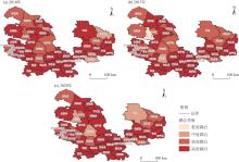
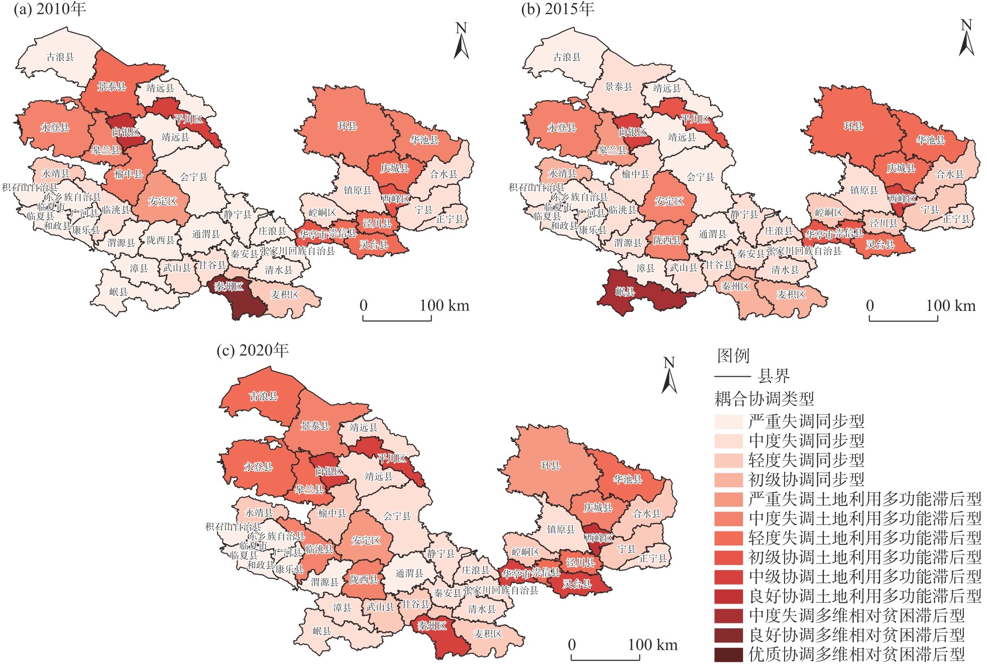
| [1] |
刘愿理, 廖和平, 蔡进, 等. 西南山区土地利用多功能与多维相对贫困的时空耦合关系[J]. 中国人口·资源与环境, 2020, 30(10): 154-164.
|
|
[ Liu Yuanli, Liao Heping, Cai Jin, et al. Spatio-temporal coupling relationship between multi-functionality of land use and multi-dimensional poverty in China’s southwestern mountainous areas[J]. China Population, Resources and Environment, 2020, 30(10): 154-164. ]
|
| [2] |
张一达, 刘学录, 范亚红, 等. 基于改进TOPSIS法的兰州市土地利用多功能性评价[J]. 干旱区地理, 2019, 42(2): 444-451.
|
|
[ Zhang Yida, Liu Xuelu, Fan Yahong, et al. Multi-functional evaluation on land use in Lanzhou City based on the improved TOPSIS[J]. Arid Land Geography, 2019, 42(2): 444-451. ]
|
| [3] |
柳梦琪, 曾忠平. 基于熵权TOPSIS法的武汉市土地利用多功能性评价[J]. 水土保持通报, 2021, 41(2): 314-321.
|
|
[ Liu Mengqi, Zeng Zhongping. Evaluation of multi-functionality of land use based on entropy-weight TOPSIS method in Wuhan City[J]. Bulletin of Soil and Water Conservation, 2021, 41(2): 314-321. ]
|
| [4] |
孙丕苓, 许月卿, 刘庆果, 等. 环京津贫困带土地利用多功能性的县域尺度时空分异及影响因素[J]. 农业工程学报, 2017, 33(15): 283-292.
|
|
[ Sun Piling, Xu Yueqing, Liu Qingguo, et al. Spatiotemporal differentiation and driving factors of multi-functionality of land use in county scale in poverty belt around Beijing and Tianjin[J]. Transactions of the Chinese Society of Agricultural Engineering, 2017, 33(15): 283-292. ]
|
| [5] |
张家琛, 党怡雯, 陈亚恒. 阜平县北流河区域土地多功能利用分区研究[J]. 林业与生态科学, 2021, 36(4): 343-352.
|
|
[ Zhang Jiachen, Dang Yiwen, Chen Yaheng. Study on multi-functional land use division in Beiliuhe region of Fuping County[J]. Forestry and Ecological Sciences, 2021, 36(4): 343-352. ]
|
| [6] |
马振邦, 王思鉴, 李薇, 等. 1986—2020年甘肃省六盘山片区贫困演变及启示[J]. 干旱区地理, 2023, 46(9): 1545-1555.
|
|
[ Ma Zhenbang, Wang Sijian, Li Wei, et al. Poverty evolution and its implications in the Liupan Mountain Area of Gansu Province during 1986—2020[J]. Arid Land Geography, 2023, 46(9): 1545-1555. ]
|
| [7] |
黄莹, 韦燕飞, 李莹, 等. 贫困与土地利用变化时空耦合关系分析——以田阳县为例[J]. 安徽农业科学, 2017, 45(27): 203-207,258.
|
|
[ Huang Ying, Wei Yanfei, Li Ying, et al. Analysis of time-space-coupling relationship between poverty and land use change: A case study of Tianyang County[J]. Journal of Anhui Agricultural Science, 2017, 45(27): 203-207, 258. ]
|
| [8] |
刘彦随. 现代人地关系与人地系统科学[J]. 地理科学, 2020, 40(8): 1221-1234.
|
|
[ Liu Yansui. Modern human-earth relationship and human-earth system science[J]. Scientia Geographica Sinica, 2020, 40(8): 1221-1234. ]
|
| [9] |
盛羊羊, 林彤, 刘新平, 等. 欠发达地区土地利用多功能化演变的时空轨迹: 来自西北典型城市的证据[J]. 东北师大学报(自然科学版), 2022, 54(2): 150-160.
|
|
[ Sheng Yangyang, Lin Tong, Liu Xinping, et al. Spatiotemporal trajectories of land use multifunctional evolution in less-developed regions: Evidence from typical cities in northwest China[J]. Journal of Northeast Normal University (Natural Science Edition), 2022, 54(2): 150-160. ]
|
| [10] |
孙进, 张全景, 王世清. 山东省县域土地利用多功能时空演变及影响因素[J]. 资源开发与市场, 2021, 37(11): 1309-1315.
|
|
[ Sun Jin, Zhang Quanjing, Wang Shiqing. Spatial-temporal variability and imfluencing factors of multi-functionality of land use in county scale in Shandong Province[J]. Resource Development & Market, 2021, 37(11): 1309-1315. ]
|
| [11] |
Qiao W Y, Hu B, Guo Z, et al. Evaluating the sustainability of land use integrating SDGs and its driving factors: A case study of the Yangtze River Delta urban agglomeration, China[J]. Cities, 2023, 143: 104569, doi: 10.1016/j.cities.2023.104569.
|
| [12] |
李广东, 方创琳. 城市生态-生产-生活空间功能定量识别与分析[J]. 地理学报, 2016, 71(1): 49-65.
|
|
[ Li Guangdong, Fang Chuanglin. Quantitative function identification and analysis of urban ecological-production-living spaces[J]. Acta Geographica Sinica, 2016, 71(1): 49-65. ]
|
| [13] |
刘愿理, 廖和平, 李涛, 等. 山区土地利用多功能时空分异特征及影响因素分析[J]. 农业工程学报, 2019, 35(21): 271-279.
|
|
[ Liu Yuanli, Liao Heping, Li Tao, et al. Spatio-temporal diversity and influencing factors of multi-functionality of land use in mountainous regions[J]. Transactions of the Chinese Society of Agricultural Engineering, 2019, 35(21): 271-279. ]
|
| [14] |
梁小英, 顾铮鸣, 雷敏, 等. 土地功能与土地利用表征土地系统和景观格局的差异研究——以陕西省蓝田县为例[J]. 自然资源学报, 2014, 29(7): 1127-1135.
|
|
[ Liang Xiaoying, Gu Zhengming, Lei Min, et al. The differences between land use function and land use to reflecting the change of land use system and their impacts on landscape pattern: A case study of Lantian County in Shaanxi Province, China[J]. Journal of Natural Resources, 2014, 29(7): 1127-1135. ]
|
| [15] |
Ren J, Ma R R, Huang Y H, et al. Identifying the trade-offs and synergies of land use functions and their influencing factors of Lanzhou-Xining urban agglomeration in the upper reaches of Yellow River Basin, China[J]. Ecological Indicators, 2024, 158: 111279, doi: 10.1016/j.ecolind.2023.111279.
|
| [16] |
孟志华, 余瀚, 任浩东. 基于GIS技术的甘肃省多维贫困识别与评价问题研究[J]. 桂林航天工业学院学报, 2019, 24(2): 233-242.
|
|
[ Meng Zhihua, Yu Han, Ren Haodong. Study on identification and evaluation of multidimensional poverty in Gansu based on GIS technology[J]. Journal of Guilin University of Aerospace Technology, 2019, 24(2): 233-242. ]
|
| [17] |
Wang Z Y, Wang W X, Yu L H, et al. Multidimensional poverty alleviation effect of different rural land consolidation models: A case study of Hubei and Guizhou, China[J]. Land Use Policy, 2022, 123: 106399, doi: 10.1016/j.landusepol.2022.106399.
|
| [18] |
田甜, 朱宏城, 李孟冉. 相对贫困视角下农村土地流转的多维减贫效应研究——基于福建省革命老区农户调查的实证分析[J]. 中国农业资源与区划, 2024, 45(10): 169-183.
|
|
[ Tian Tian, Zhu Hongcheng, Li Mengran. Study on the multidimensional poverty reduction effect oof rural land transfer under the perspective of relative poverty: An empiricallanalysis based on the survey of farmers in the old revolutionary base areas of Fujian[J]. Chinese Journal of Agricultural Resources and Regional Planning, 2024, 45(10): 169-183. ]
|
| [19] |
王会, 侯庆丰. 可持续生计视角下甘肃农户相对贫困多维测度研究[J]. 干旱区资源与环境, 2024, 38(3): 56-64.
|
|
[ Wang Hui, Hou Qingfeng. Multidimensional measurement on relative poverty of farmers in Gansu from the perspective of sustainable livelihood[J]. Journal of Arid Land Resources and Environment, 2024, 38(3): 56-64. ]
|
| [20] |
蒲金芳, 王亚楠, 张蚌蚌, 等. 赣东山地丘陵区土地利用多功能与乡村发展的时空耦合关系[J]. 中国农业大学学报, 2022, 27(4): 256-269.
|
|
[ Pu Jinfang, Wang Yanan, Zhang Bangbang, et al. Spatiotemporal coupling relationship between land use multifunctions and rural development level in hilly region of eastern Jiangxi Province[J]. Journal of China Agricultural University, 2022, 27(4): 256-269. ]
|
| [21] |
Liu C, Xu Y Q, Huang A, et al. Spatial identification of land use multifunctionality at grid scale in farming-pastoral area: A case study of Zhangjiakou City, China[J]. Habitat International, 2018(76): 48-61.
|
| [22] |
刘超, 许月卿, 刘焱序, 等. 基于系统论的土地利用多功能分类及评价指标体系研究[J]. 北京大学学报(自然科学版), 2018, 54(1): 181-188.
|
|
[ Liu Chao, Xu Yueqing, Liu Yanxu, et al. Research on land use functions classification and evaluation system based on system theory[J]. Acta Scientiarum Naturalium Universitatis Pekinensis, 2018, 54(1): 181-188. ]
|
| [23] |
陈万远, 赵锐锋. “三生”功能视角下甘肃省土地利用时空演变及影响因素[J]. 甘肃农业大学学报, 2024, 59(2): 262-274, 281.
|
|
[ Chen Wanyuan, Zhao Ruifeng. Spatial-temporal evolution of land use and its influencing factors from the perspective of production-living-ecological function in Gansu Province[J]. Journal of Gansu Agricultural University, 2024, 59(2): 262-274, 281. ]
|
| [24] |
张悦, 吴克宁, 李晓亮, 等. 河北省县域土地利用多功能性时空分异与耦合协调度研究[J]. 中国农业资源与区划, 2024, 45(8): 150-161.
|
|
[ Zhang Yue, Wu Kening, Li Xiaoliang, et al. Study on spadial-temporal differentiation and coupling coordination degree of multi-functionality of ccounty land use in Hebei Provincee[J]. Chinese Journal of Agricultural Resources and Regional Planning, 2024, 45(8): 150-161. ]
|
| [25] |
牛雅萱, 吴世新, 郭晨宇, 等. 新疆县市“三生”功能时空变化及耦合协调性分析[J]. 干旱区地理, 2021, 44(6): 1821-1835.
|
|
[ Niu Yaxuan, Wu Shixin, Guo Chenyu, et al. Spatio-temporal changes and coupling coordination of the function of “production-living-ecological” in Xinjiang[J]. Arid Land Geography, 2021, 44(6): 1821-1835. ]
|
| [26] |
周常春, 翟羽佳, 车震宇. 连片特困区农户多维贫困测度及能力建设研究[J]. 中国人口·资源与环境, 2017, 27(11): 95-103.
|
|
[ Zhou Changchun, Zhai Yujia, Che Zhenyu. Research on the multidimensional poverty and capability building[J]. China Population, Resources and Environment, 2017, 27(11): 95-103. ]
|
| [27] |
王建军, 杨辉平. 新疆区域多维贫困测度及评价[J]. 新疆农垦经济, 2014(12): 88-92.
|
|
[ Wang Jianjun, Yang Huiping. Measurement and evaluation of multidimensional poverty in Xinjiang[J]. Xinjiang State Farms Economy, 2014(12): 88-92. ]
|
| [28] |
刘苗苗, 吴卫东. 陕西省新型城镇化与乡村振兴耦合性实证研究[J]. 干旱区地理, 2024, 47(8): 1420-1430.
|
|
[ Liu Miaomiao, Wu Weidong. Empirical study on the coupling of new urbanization and rural revitalization in Shaanxi Province[J]. Arid Land Geography, 2024, 47(8): 1420-1430. ]
|
| [29] |
蔡怀滨, 王枫. 广东省贫困县土地利用多功能与脱贫成效耦合协调关系及障碍诊断[J]. 农业资源与环境学报, 2024, 41(4): 976-988.
|
|
[ Cai Huaibin, Wang Feng. The coupling coordination relationship and obstacle diagnosis of land use functions and poverty alleviation effect in the poverty-stricken counties of Guangdong Province[J]. Journal of Agricultural Resources and Environment, 2024, 41(4): 976-988. ]
|
| [30] |
夏兴, 乔家君, 徐洋, 等. 农户多维相对贫困与生计多样性的耦合关系——以安徽省阜南县为例[J]. 经济地理, 2023, 43(4): 164-173.
|
|
[ Xia Xing, Qiao Jiajun, Xu Yang, et al. Coupling relationship between multidimensional relative poverty and livelihood diversity of farming households: A case of Funan County in Anhui Province, China[J]. Economic Geography, 2023, 43(4): 164-173. ]
|
 ), 谢保鹏(