干旱区地理 ›› 2025, Vol. 48 ›› Issue (2): 308-322.doi: 10.12118/j.issn.1000-6060.2024.320 cstr: 32274.14.ALG2024320
张子涵1,2( ), 王瑾杰1,2, 丁建丽2,3(), 张锦明1,2, 葛翔宇1,2
收稿日期:2024-05-26
修回日期:2024-06-11
出版日期:2025-02-25
发布日期:2025-02-25
通讯作者:
丁建丽(1974-),男,博士,教授,主要从事干旱区遥感与GIS应用研究. E-mail: dingjl@xju.edu.cn作者简介:张子涵(2002-),女,硕士研究生,主要从事干旱区生态水文研究. E-mail: 107552301154@stu.xju.edu.cn
基金资助:
ZHANG Zihan1,2(), WANG Jinjie1,2, DING Jianli2,3(), ZHANG Jinming1,2, GE Xiangyu1,2
Received:2024-05-26
Revised:2024-06-11
Published:2025-02-25
Online:2025-02-25
摘要:
景观生态风险评价是地理学、生态学研究衍生出来的新研究方向,在区域生态环境评价和国土资源规划中具有重要意义。以艾比湖流域为研究区,选取1990、2000、2010年和2020年土地利用遥感解译数据产品,定量分析30 a间土地利用动态变化特征。同时,基于景观风险生态指数,采用地统计学方法,探究艾比湖流域景观生态风险程度及时空分异特征,并利用PLUS模型模拟预测艾比湖流域2030年未来多情景下的土地利用及景观生态风险空间分布格局。结果表明:(1) 流域土地利用类型以草地和裸地为主,占总面积70%以上,而灌木和湿地的面积相对较少;1990—2020年农田和不透水地表面积增加幅度明显,草地面积减少,是主要的土地利用转换类型。(2) 1990—2020年流域景观生态风险全局Moran’s I均显著为正,流域景观生态风险持续上升且具有聚集效应,呈“边缘低、中间高”的空间分布规律。(3) 所模拟的艾比湖流域2030年不同情景下艾比湖流域景观类型变化趋于平稳,草地和裸地仍然是最主要的土地利用类型。(4) 2030年艾比湖流域不同情景下的景观生态风险分布与历史分布相似,综合来看,生态保护情景在社会经济发展的前提下有利于缓解流域景观生态风险,更符合可持续发展的需要。
张子涵, 王瑾杰, 丁建丽, 张锦明, 葛翔宇. 基于PLUS模型的艾比湖流域景观生态风险分析及预测[J]. 干旱区地理, 2025, 48(2): 308-322.
ZHANG Zihan, WANG Jinjie, DING Jianli, ZHANG Jinming, GE Xiangyu. Analysis and prediction of landscape ecological risk in Ebinur Lake Basin based on PLUS model[J]. Arid Land Geography, 2025, 48(2): 308-322.
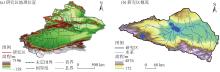
图1
研究区示意图 注:基于自然资源部标准地图服务网站审图号为GS(2024)0650号的标准地图制作,底图边界无修改。"
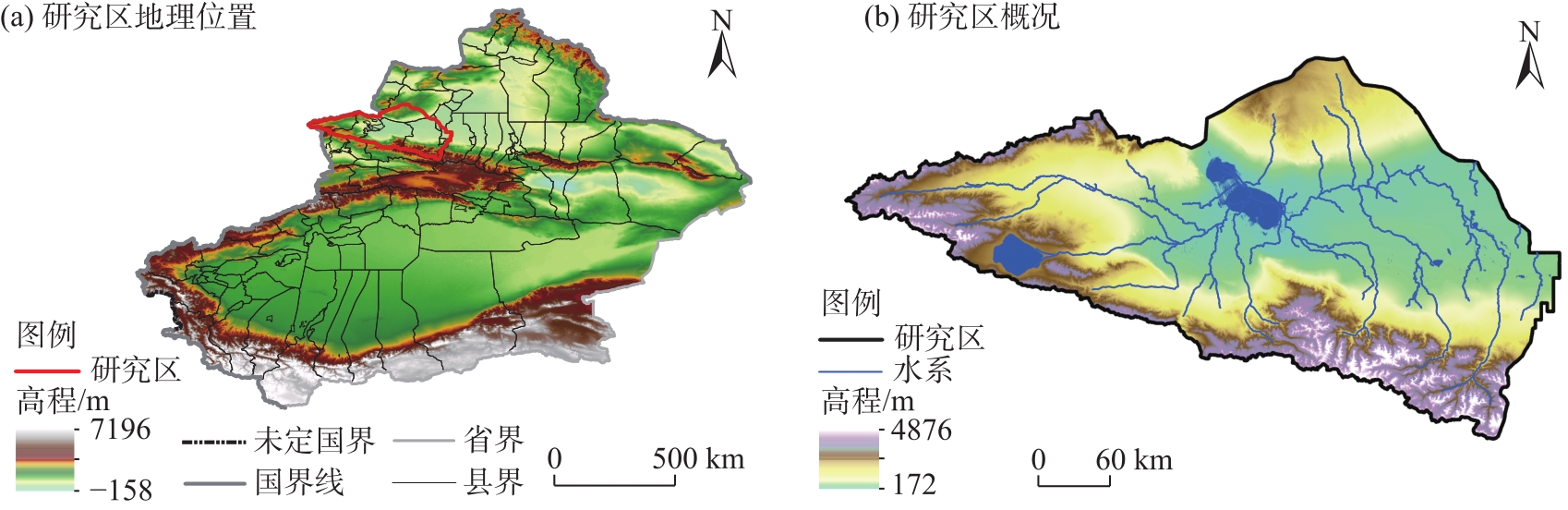
表1
研究数据来源及信息"
| 数据类型 | 数据名称 | 数据来源 |
|---|---|---|
| 基础数据 | 土地利用数据 | 武汉大学黄昕教授团队制作的中国30 m分辨率年度土地覆盖产品,产品整体精度为79.31%( |
| 行政边界数据 | 中国科学院资源环境与数据中心( | |
| 社会经济数据 | 人口 | Worldpop( |
| GDP | 中国科学院资源环境与数据中心( | |
| 距一级道路距离 | OpenStreetMap( OpenStreetMap( OpenStreetMap( OpenStreetMap( OpenStreetMap( | |
| 距二级道路距离 | ||
| 距三级道路距离 | ||
| 距铁路距离 | ||
| 距高速距离 | ||
| 气候环境数据 | 高程 | 地理空间数据云( |
| 坡度 | 地理空间数据云( | |
| 年降水量 | 中国科学院资源环境与数据中心( 中国科学院资源环境与数据中心( 中国科学院资源环境与数据中心( 中国科学院资源环境与数据中心( | |
| 年均气温 | ||
| 土壤类型数据 | ||
| NDVI |
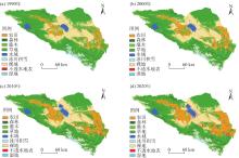
图2
1990—2020年研究区土地利用类型分布"
表2
1990—2020年艾比湖流域各土地利用类型面积变化"
| 土地利用类型 | 1990年 | 2000年 | 2010年 | 2020年 | |||||||
|---|---|---|---|---|---|---|---|---|---|---|---|
| 面积/km2 | 占比/% | 面积/km2 | 占比/% | 面积/km2 | 占比/% | 面积/km2 | 占比/% | ||||
| 农田 | 3709.40 | 7.83 | 4678.50 | 9.87 | 6384.30 | 13.47 | 7383.80 | 15.58 | |||
| 森林 | 511.10 | 1.08 | 728.00 | 1.54 | 897.10 | 1.89 | 1039.02 | 2.19 | |||
| 灌木 | 0.09 | 0.00 | 0.01 | 0.00 | 0.01 | 0.00 | 0.05 | 0.00 | |||
| 草地 | 29115.40 | 61.45 | 27175.50 | 57.36 | 26707.50 | 56.37 | 25238.50 | 53.27 | |||
| 水域 | 1113.40 | 2.35 | 1268.30 | 2.68 | 1464.00 | 3.09 | 1512.10 | 3.19 | |||
| 冰川积雪 | 1390.90 | 2.94 | 1211.00 | 2.56 | 1300.10 | 2.74 | 1185.50 | 2.50 | |||
| 裸地 | 11514.10 | 24.30 | 12177.70 | 25.70 | 10238.40 | 21.61 | 10384.50 | 21.92 | |||
| 不透水地表 | 25.80 | 0.05 | 141.20 | 0.30 | 388.80 | 0.82 | 636.70 | 1.34 | |||
| 湿地 | 0.89 | 0.002 | 0.86 | 0.002 | 0.82 | 0.002 | 0.88 | 0.002 | |||
表3
1990—2020年艾比湖流域土地利用类型动态度变化"
| 土地利用类型 | 单一土地利用动态度/% | |||
|---|---|---|---|---|
| 1990—2000年 | 2000—2010年 | 2010—2020年 | 1990—2020年 | |
| 农田 | 2.61 | 3.65 | 1.57 | 3.30 |
| 森林 | 4.25 | 2.32 | 1.58 | 3.45 |
| 灌木 | -7.97 | -3.13 | 42.73 | -0.89 |
| 草地 | -0.67 | -0.17 | -0.55 | -0.44 |
| 水域 | 1.39 | 1.54 | 0.33 | 1.19 |
| 冰川积雪 | -1.29 | 0.74 | -0.88 | -0.49 |
| 裸地 | 0.57 | -1.59 | 0.14 | -0.33 |
| 不透水地表 | 45.15 | 17.53 | 6.38 | 79.54 |
| 湿地 | -0.64 | -0.49 | 0.72 | -0.15 |
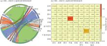
图3
1990—2020年艾比湖流域土地利用转移矩阵"
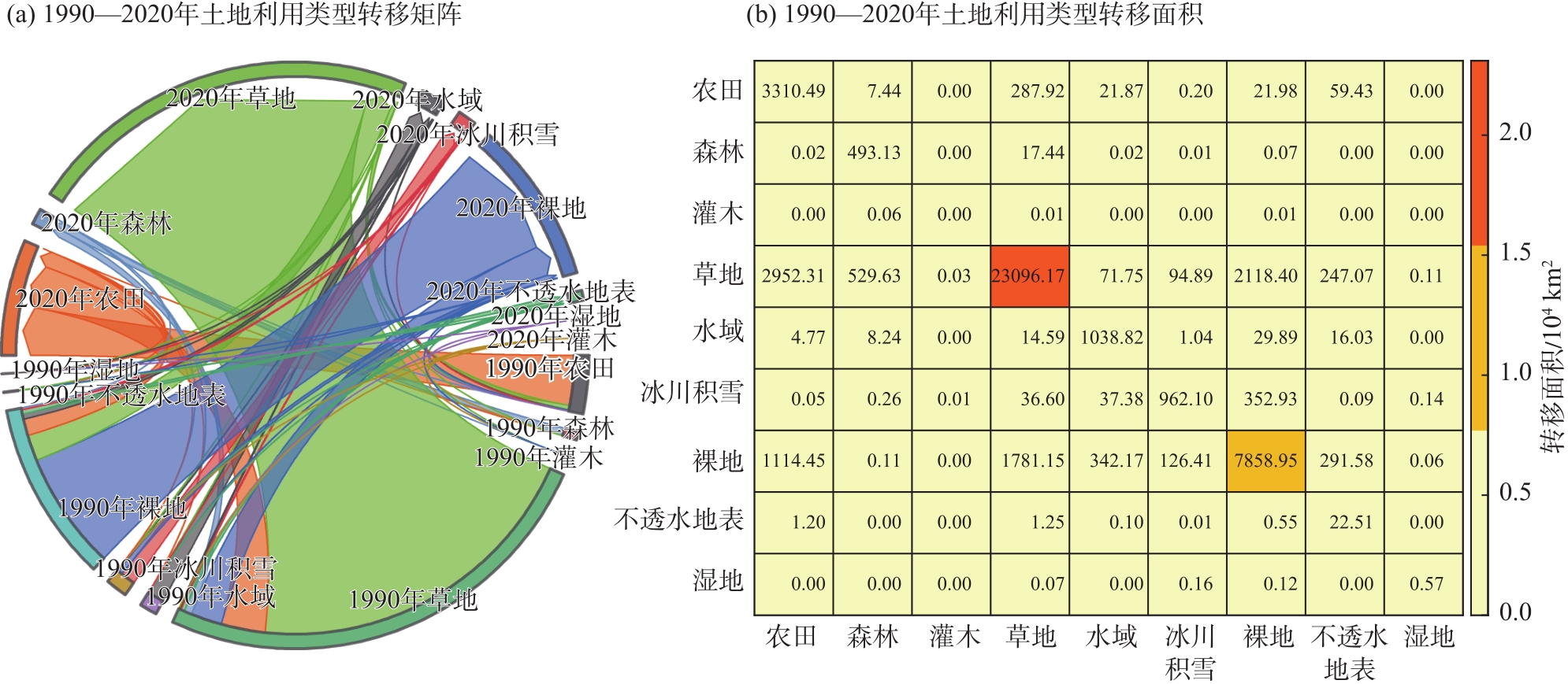
图4
1990—2020年艾比湖流域景观生态风险空间分布"
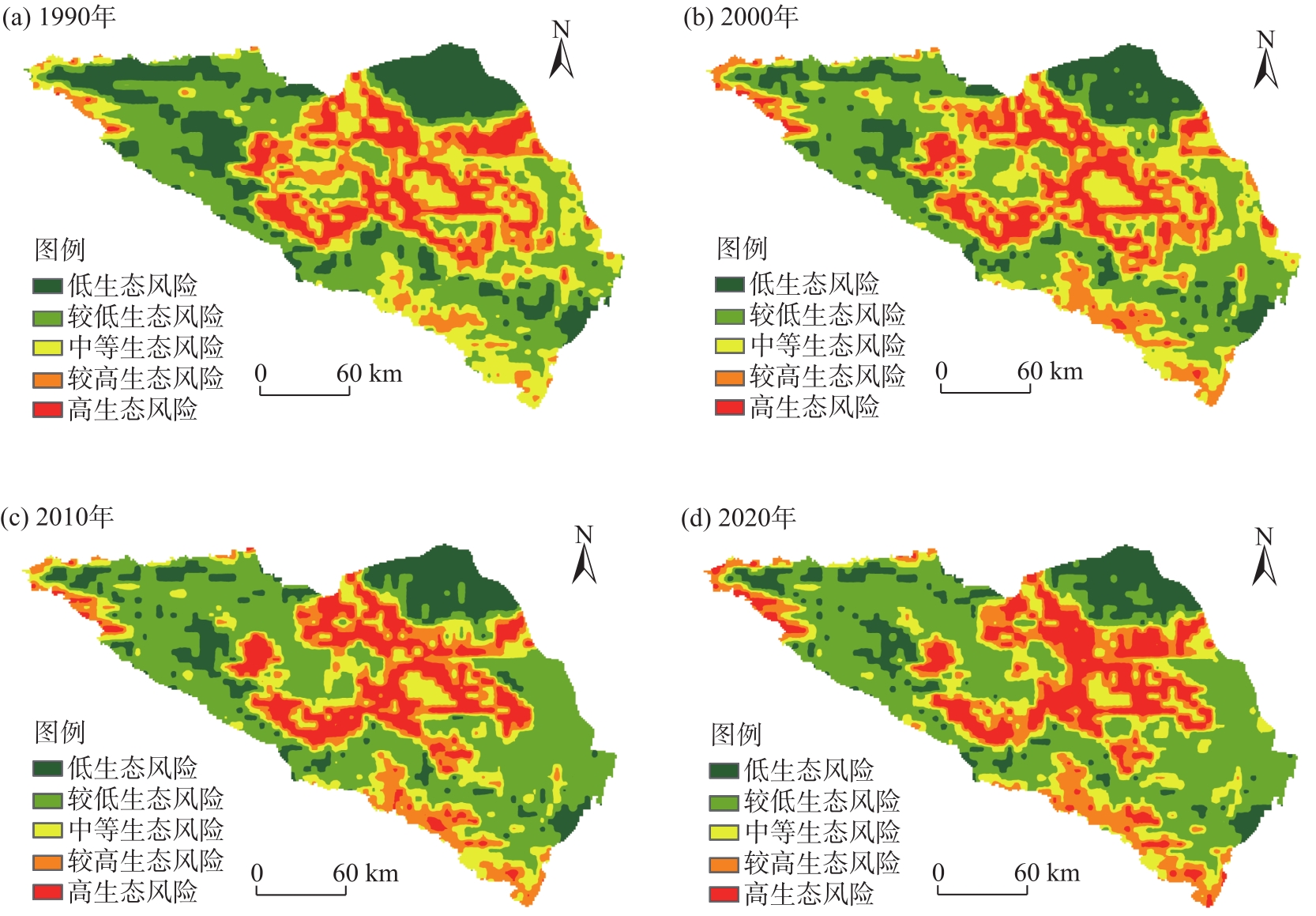
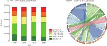
图5
1990—2020年艾比湖流域景观生态风险面积转移"

表4
1990—2020年艾比湖流域景观生态风险面积变化"
| 生态风险等级 | 1990年 | 2000年 | 2010年 | 2020年 | |||||||
|---|---|---|---|---|---|---|---|---|---|---|---|
| 面积/km2 | 占比/% | 面积/km2 | 占比/% | 面积/km2 | 占比/% | 面积/km2 | 占比/% | ||||
| 低生态风险 | 8892.86 | 18.76 | 6970.40 | 14.71 | 6261.86 | 13.21 | 5659.81 | 11.94 | |||
| 较低生态风险 | 15431.70 | 32.56 | 16789.40 | 35.42 | 20668.50 | 43.60 | 20459.90 | 43.16 | |||
| 中等生态风险 | 10864.90 | 22.92 | 10391.70 | 21.92 | 7805.86 | 16.47 | 7793.12 | 16.44 | |||
| 较高生态风险 | 6997.43 | 14.76 | 7851.17 | 16.56 | 6700.01 | 14.13 | 7172.48 | 15.13 | |||
| 高生态风险 | 5213.46 | 11.00 | 5397.66 | 11.39 | 5964.09 | 12.58 | 6315.05 | 13.32 | |||
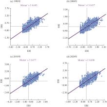
图6
1990—2020年艾比湖流域景观生态风险莫兰指数 注:ERI为景观生态风险指数。下同。"

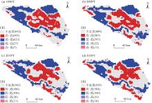
图7
1990—2020年景观生态风险LISA聚类图"
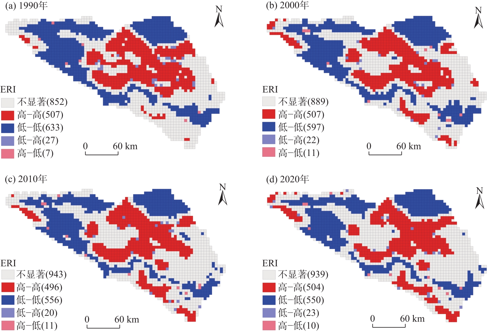

图8
2030年艾比湖流域各情景土地利用类型分布"

表5
2030年艾比湖流域不同情境下土地利用类型面积变化"
| 土地利用类型 | 自然发展情景 | 城镇发展情景 | 生态保护情景 | 耕地保护情景 | |||||||
|---|---|---|---|---|---|---|---|---|---|---|---|
| 面积/km2 | 占比/% | 面积/km2 | 占比/% | 面积/km2 | 占比/% | 面积/km2 | 占比/% | ||||
| 农田 | 8250.15 | 17.41 | 8125.64 | 17.15 | 7344.16 | 15.50 | 8268.81 | 17.45 | |||
| 森林 | 1173.89 | 2.48 | 1173.78 | 2.48 | 1212.53 | 2.56 | 1173.92 | 2.48 | |||
| 灌木 | 0.06 | 0.00 | 0.05 | 0.00 | 0.05 | 0.00 | 0.07 | 0.00 | |||
| 草地 | 24008.80 | 50.67 | 23996.60 | 50.65 | 25515.40 | 53.85 | 24010.00 | 50.67 | |||
| 水域 | 1555.44 | 3.28 | 1555.06 | 3.28 | 1550.53 | 3.27 | 1555.46 | 3.28 | |||
| 冰川积雪 | 1235.62 | 2.61 | 1221.42 | 2.58 | 1212.16 | 2.56 | 1234.31 | 2.61 | |||
| 裸地 | 10401.40 | 21.95 | 10400.70 | 21.95 | 9883.60 | 20.86 | 10401.40 | 21.95 | |||
| 不透水地表 | 755.25 | 1.59 | 907.36 | 1.92 | 661.68 | 1.40 | 736.69 | 1.55 | |||
| 湿地 | 0.42 | 0.00 | 0.42 | 0.00 | 0.89 | 0.00 | 0.37 | 0.00 | |||
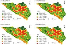
图9
2030年艾比湖流域各情景景观生态风险空间分布"

表6
2030年艾比湖流域各情景景观生态风险等级面积"
| 生态风险等级 | 自然发展情景 | 城镇发展情景 | 生态保护情景 | 耕地保护情景 | |||||||
|---|---|---|---|---|---|---|---|---|---|---|---|
| 面积/km2 | 占比/% | 面积/km2 | 占比/% | 面积/km2 | 占比/% | 面积/km2 | 占比/% | ||||
| 低生态风险 | 5977.28 | 12.61 | 5891.53 | 12.43 | 6088.50 | 12.84 | 5886.65 | 12.42 | |||
| 较低生态风险 | 20865.60 | 43.02 | 20957.40 | 44.21 | 20905.90 | 44.10 | 20921.70 | 44.14 | |||
| 中等生态风险 | 7705.54 | 16.26 | 7798.08 | 16.45 | 7883.72 | 16.63 | 7745.13 | 16.34 | |||
| 较高生态风险 | 6783.66 | 14.31 | 6759.80 | 14.26 | 6856.28 | 14.46 | 6752.29 | 14.25 | |||
| 高生态风险 | 6068.27 | 12.80 | 5993.57 | 12.64 | 5665.92 | 11.95 | 6094.58 | 12.86 | |||
| [2] | Tian P, Li J L, Gong H B, et al. Research on land use changes and ecological risk assessment in Yongjiang River Basin in Zhejiang Province, China[J]. Sustainability, 2019, 1(10): 2817, doi: 10.3390/su11102817. |
| [3] | 莫贵芬, 冯建中, 王中美, 等. 中亚阿姆河跨境流域景观生态风险时空演变特征分析[J]. 干旱地区农业研究, 2022, 40(1): 123-131. |
| [Mo Guifen, Feng Jianzhong, Wang Zhongmei, et al. Spatial-temporal evolution characteristics of landscape ecological risk in the transboundary basin of Amu Darya River, Central Asia[J]. Agricultural Research in the Arid Areas, 2022, 40(1): 123-131. ] | |
| [4] |
Huang H, Wang P, Xie H. Ecological risk assessment of land use change in the Poyang Lake eco-economic zone, China[J]. International Journal of Environmental Research and Public Health, 2013, 10(1): 328-346.
doi: 10.3390/ijerph10010328 pmid: 23343986 |
| [5] | 汪翡翠, 汪东川, 张利辉, 等. 京津冀城市群土地利用生态风险的时空变化分析[J]. 生态学报, 2018, 38(12): 4307-4316. |
| [Wang Feicui, Wang Dongchuan, Zhang Lihui, et al. Spatiotemporal analysis of the dynamic changes in land use ecological risks in the urban agglomeration of Beijing-Tianjin-Hebei region[J]. Acta Ecologica Sinica, 2018, 38(12): 4307-4316. ] | |
| [6] | 井云清, 张飞, 陈丽华, 等. 艾比湖湿地土地利用/覆被-景观格局和气候变化的生态环境效应研究[J]. 环境科学学报, 2017, 37(9): 3590-3601. |
| [Jing Yunqing, Zhang Fei, Chen Lihua, et al. Investigation on eco-environmental effects of land use/cover-landscape pattern and climate change in Ebinur Lake Wetland Nature Reserve[J]. Acta Scientiae Circumstantiae, 2017, 37(9): 3590-3601. ] | |
| [7] | Gao L N, Tao F, Liu R R, et al. Multi-scenario simulation and ecological risk analysis of land use based on the PLUS model: A case study of Nanjing[J]. Sustainable Cities and Society, 2022, 85: 104055, doi: 10.1016/j.scs.2022.104055. |
| [8] |
彭建, 党威雄, 刘焱序, 等. 景观生态风险评价研究进展与展望[J]. 地理学报, 2015, 70(4): 664-677.
doi: 10.11821/dlxb201504013 |
|
[Peng Jian, Dang Weixiong, Liu Yanxu, et al. Review on landscape ecological risk assessment[J]. Acta Geographica Sinica, 2015, 70(4): 664-677. ]
doi: 10.11821/dlxb201504013 |
|
| [9] | 刘琪. 基于土地利用变化的延河流域景观生态风险评价[D]. 西安: 西北大学, 2016. |
| [Liu Qi. Landscape ecological risk assessment of Yanhe watershed based on land use change[D]. Xi’an: Northwest University, 2016. ] | |
| [10] |
曹祺文, 张曦文, 马洪坤, 等. 景观生态风险研究进展及基于生态系统服务的评价框架: ESRISK[J]. 地理学报, 2018, 73(5): 843-855.
doi: 10.11821/dlxb201805005 |
|
[Cao Qiwen, Zhang Xiwen, Ma Hongkun, et al. Review of landscape ecological risk and an assessment framework based on ecological services ESRISK[J]. Acta Geographica Sinica, 2018, 73(5): 843-855. ]
doi: 10.11821/dlxb201805005 |
|
| [11] | 康紫薇, 张正勇, 位宏, 等. 基于土地利用变化的玛纳斯河流域景观生态风险评价[J]. 生态学报, 2020, 40(18): 6472-6485. |
| [Kang Ziwei, Zhang Zhengyong, Wei Hong, et al. Landscape ecological risk assessment in Manas River Basin based on land use change[J]. Acta Ecologica Sinica, 2020, 40(18): 6472-6485. ] | |
| [12] | 吕乐婷, 张杰, 孙才志, 等. 基于土地利用变化的细河流域景观生态风险评估[J]. 生态学报, 2018, 38(16): 5952-5960. |
| [Lü Leting, Zhang Jie, Sun Caizhi, et al. Landscape ecological risk assessment of Xi River Basin based on land-use change[J]. Acta Ecologica Sinica, 2018, 38(16): 5952-5960. ] | |
| [13] | 郝军, 田雅楠, 戈锋, 等. 嫩江中游内蒙古段土地利用与景观生态风险响应关系研究[J]. 中国环境科学, 2023, 43(11): 6132-6140. |
| [Hao Jun, Tian Ya’nan, Ge Feng, et al. Correlational relationship between land use and landscape ecological risks in Inner Mongolia section of middle Nenjiang[J]. China Environmental Science, 2023, 43(11): 6132-6140. ] | |
| [14] | 陈全通, 殷浩然, 李艳红, 等. 秦巴山地景观生态风险的时空分异[J]. 水土保持通报, 2022, 42(3): 239-246. |
| [Chen Quantong, Yin Haoran, Li Yanhong, et al Spatial and temporal differentiation of landscape ecological risk in Qinling-Daba Mountains[J]. Bulletin of Soil and Water Conservation, 2022, 42(3): 239-246. ] | |
| [15] | Cui B H, Zhang Y L, Wang Z F, et al. Ecological risk assessment of transboundary region based on land-cover change: A case study of Gandaki River Basin, Himalayas[J]. Land, 2022, 11(5): 638, doi: 10.3390/land11050638. |
| [16] | 高宾, 李小玉, 李志刚, 等. 基于景观格局的锦州湾沿海经济开发区生态风险分析[J]. 生态学报, 2011, 31(12): 3441-3450. |
| [Gao bin, Li Xiaoyu, Li Zhigang, et al. Assessment of ecological risk of coastal economic developing zone in Jinzhou Bay based on landscape pattern[J]. Acta Ecologica Sinica, 2011, 31(12): 3441-3450. ] | |
| [17] | Hamad R, Balzter H, Kolo K. Predicting land use/land cover changes using a CA-Markov model under two different scenarios[J]. Sustainability, 2018, 10(10): 3421, doi: 10.3390/su10103421. |
| [18] | Peng J, Hu X X, Wang X Y, et al. Simulating the impact of Grain-for-Green Programme on ecosystem services trade-offs in northwestern Yunnan, China[J]. Ecosystem Services, 2019, 39: 100998, doi: 10.1016/j.ecoser.2019.100998. |
| [19] | 王保盛, 廖江福, 祝薇, 等. 基于历史情景的FLUS模型邻域权重设置——以闽三角城市群2030年土地利用模拟为例[J]. 生态学报, 2019, 39(12): 4284-4298. |
| [Wang Baosheng, Liao Jiangfu, Zhu Wei, et al. The weight of neighborhood setting of the FLUS model based on a historical scenario: A case study of land use simulation of urban agglomeration of the Golden Triangle of southern Fujian in 2030[J]. Acta Ecologica Sinica, 2019, 39(12): 4284-4298. ] | |
| [20] | 周满意, 王承武. 基于PLUS模型的乌鲁木齐市“三生”空间多情景模拟[J]. 中国环境科学, 2024, 44(7): 4021-4030. |
| [Zhou Manyi, Wang Chengwu. Multi-scenario simulation of “production-livelihood-ecological” space in Urumqi based on PLUS[J]. China Environmental Science, 2024, 44(7): 4021-4030. ] | |
| [21] | Han J Z, Hu Z Q, Wang P J, et al. Spatio-temporal evolution and optimization analysis of ecosystem service value: A case study of coal resource-based city group in Shandong, China[J]. Journal of Cleaner Production, 2022, 363: 132602, doi: 10.1016/J.JCLEPRO.2022.132602. |
| [22] | 杨朔, 苏昊, 赵国平. 基于PLUS模型的城市生态系统服务价值多情景模拟——以汉中市为例[J]. 干旱区资源与环境, 2022, 36(10): 86-95. |
| [Yang Shuo, Su Hao, Zhao Guoping. Multi-scenario simulation of urban ecosystem service value based on PLUS model: A case study of Hanzhong City[J]. Journal of Arid Land Resources and Environment, 2022, 36(10): 86-95. ] | |
| [23] |
张艳, 李骏南, 潘博华. 基于PLUS模型的黄河流域生态系统服务评价及多情景预测——以陕西段为例[J]. 干旱区地理, 2024, 47(11): 1935-1946.
doi: 10.12118/j.issn.1000-6060.2023.651 |
|
[Zhang Yan, Li Junnan, Pan Bohua. Evaluation and multi-scenario prediction of ecosystem services in the Yellow River Basin based on PLUS model: A case of Shaanxi section[J]. Arid Land Geography, 2024, 47(11): 1935-1946. ]
doi: 10.12118/j.issn.1000-6060.2023.651 |
|
| [24] | 雷小牛, 李宏健, 刘艳红, 等. 新疆艾比湖流域生态环境保护修复治理的基本思路及对策[J]. 水利发展研究, 2023, 23(5): 38-48. |
| [Lei Xiaoniu, Li Hongjian, Liu Yanhong, et al. Basic ideas and measures of ecological environment protection, restoration and governance in Ebinur Lake Basin in Xinjiang[J]. Water Resources Development Research, 2023, 23(5): 38-48. ] | |
| [25] |
刘景明, 丁建丽, 包青岭, 等. 基于同位素揭示艾比湖流域地下水特征[J]. 干旱区地理, 2023, 46(2): 201-210.
doi: 10.12118/j.issn.1000-6060.2022.228 |
|
[Liu Jingming, Ding Jianli, Bao Qingling, et al. Characteristics of groundwater in Ebinur Lake Basin using isotopes method[J]. Arid Land Geography, 2023, 46(2): 201-210. ]
doi: 10.12118/j.issn.1000-6060.2022.228 |
|
| [26] |
丁建丽, 葛翔宇, 王敬哲. 中国艾比湖湿地识别及其时空动态变化[J]. 自然资源学报, 2021, 36(8): 1949-1963.
doi: 10.31497/zrzyxb.20210804 |
|
[Ding Jianli, Ge Xiangyu, Wang Jingzhe. Ebinur Lake wetland identification and its spatio-temporal dynamic changes[J]. Journal of Natural Resources, 2021, 36(8): 1949-1963. ]
doi: 10.31497/zrzyxb.20210804 |
|
| [27] |
Yang J, Huang X. The 30 m annual land cover dataset and its dynamics in China from 1990 to 2019[J]. Earth System Science Data, 2021, 13(8): 3907-3925.
doi: 10.5194/essd-13-3907-2021 |
| [28] | 邓晓辉, 王琳, 欧彩虹, 等. 基于PLUS模型的长株潭都市圈景观生态风险动态分析[J]. 地理与地理信息科学, 2024, 40(1): 47-54, 98. |
| [Deng Xiaohui, Wang Lin, Ou Caihong, et al. Dynamic analysis of landscape ecological risk in Changsha, Zhuzhou and Xiangtan Metropolitan Area based on PLUS model[J]. Geography and Geo-information Science, 2024, 40(1): 47-54, 98. ] | |
| [29] | 张廷, 胡玉柱, 胡海辉, 等. 基于PLUS-InVEST模型的哈尔滨市土地利用及生境质量预测[J]. 环境科学, 2024, 45(8): 4709-4721. |
| [Zhang Ting, Hu Yuzhu, Hu Haihui, et al. Prediction of land use and habitat quality in Harbin City based on the PLUS-InVEST model[J]. Environmental Science, 2024, 45(8): 4709-4721. ] | |
| [30] | 牛统莉, 熊立华, 陈杰, 等. 基于PLUS模型的长江流域土地利用变化模拟与多情景预测[J]. 武汉大学学报(工学版), 2024, 57(2): 129-141, 151. |
| [Niu Tongli, Xiong Lihua, Chen Jie, et al. Land use simulation and multi-scenario prediction of the Yangtze River Basin based on PLUS model[J]. Engineering Journal of Wuhan University, 2024, 57(2): 129-141, 151. ] | |
| [31] | 李琛, 高彬嫔, 吴映梅, 等. 基于PLUS模型的山区城镇景观生态风险动态模拟[J]. 浙江农林大学学报, 2022, 39(1): 84-94. |
| [Li Chen, Gao Binpin, Wu Yingmei, et al. Dynamic simulation of landscape ecological risk in mountain towns based on PLUS model[J]. Journal of Zhejiang A & F University, 2022, 39(1): 84-94. ] | |
| [32] | 王敏, 胡守庚, 张绪冰, 等. 干旱区绿洲城镇景观生态风险时空变化分析——以张掖绿洲乡镇为例[J]. 生态学报, 2022, 42(14): 5812-5824. |
| [Wang Min, Hu Shougeng, Zhang Xubing, et al. Spatio-temporal evolution of landscape ecological risk in oasis cities and towns of arid area: A case study of Zhangye oasis township[J]. Acta Ecologica Sinica, 2022, 42(14): 5812-5824. ] | |
| [33] | 尉芳, 刘京, 夏利恒, 等. 基于LUCC的陕西渭北旱塬区景观生态风险评价[J]. 中国环境科学, 2022, 42(4): 1963-1974. |
| [1] | 付在毅, 许学工. 区域生态风险评价[J]. 地球科学进展, 2001, 16(2): 267-271. |
|
[Fu Zaiyi, Xu Xuegong. Regional ecological risk assessment[J]. Advances in Earth Science, 2001, 16(2): 267-271. ]
doi: 10.11867/j.issn.1001-8166.2001.02.0267 |
|
| [33] | [Wei Fang, Liu Jing, Xia Liheng, et al. Landscape ecological risk assessment in Weibei dryland region of Shaanxi Province based on LUCC[J]. China Environmental Science, 2022, 42(4): 1963-1974. ] |
| [34] | 张月, 张飞, 周梅, 等. 干旱区内陆艾比湖区域景观生态风险评价及时空分异[J]. 应用生态学报, 2016, 27(1): 233-242. |
|
[Zhang Yue, Zhang Fei, Zhou Mei, et al. Landscape ecological risk assessment and its spatio-temporal variations in Ebinur Lake region of inland arid area[J]. Chinese Journal of Applied Ecology, 2016, 27(1): 233-242. ]
pmid: 27228614 |
|
| [35] | 于航, 刘学录, 赵天明, 等. 基于景观格局的祁连山国家公园景观生态风险评价[J]. 生态科学, 2022, 41(2): 99-107. |
| [Yu Hang, Liu Xuelu, Zhao Tianming, et al. Landscape ecological risk assessment of Qilian Mountain National Park based on landscape pattern[J]. Ecological Science, 2022, 41(2): 99-107. ] | |
| [36] | Wang S Y, Liu J S, Ma T B. Dynamics and changes in spatial patterns of land use in Yellow River Basin, China[J]. Land Use Policy, 2009, 27(2): 313-323. |
| [37] | 张松林, 张昆. 全局空间自相关Moran指数和G系数对比研究[J]. 中山大学学报(自然科学版), 2007, 46(4): 93-97. |
| [Zhang Songlin, Zhang Kun. Comparison between General Moran’s index and Getis-Ord General G of spatial autocorrelation[J]. Acta Scientiarum Naturalium Universitatis Sunyatseni, 2007, 46(4): 93-97. ] | |
| [38] | Zhang M X, Bao Y B, Xü J, et al. Ecological security evaluation and ecological regulation approach of East-Liao River Basin based on ecological function area[J]. Ecological Indicators, 2021, 132: 108255, doi: 10.1016/j.ecolind.2021.108255. |
| [39] |
韩楚翘, 郑江华, 王哲, 等. 基于PLUS-InVEST模型吐哈盆地陆地生态系统碳储量时空变化及多情景模拟[J]. 干旱区地理, 2024, 47(2): 260-269.
doi: 10.12118/j.issn.1000-6060.2023.066 |
|
[Han Chuqiao, Zheng Jianghua, Wang Zhe, et al. Spatiotemporal variation and multiscenario simulation of carbon storage in terrestrial ecosystems in the Turpan-Hami Basin based on PLUS-InVEST model[J]. Arid Land Geography, 2024, 47(2): 260-269. ]
doi: 10.12118/j.issn.1000-6060.2023.066 |
|
| [40] | 李俊, 杨德宏, 吴锋振, 等. 基于PLUS与InVEST模型的昆明市土地利用变化动态模拟与碳储量评估[J]. 水土保持通报, 2023, 43(1): 378-387. |
| [Li Jun, Yang Dehong, Wu Zhenfeng, et al. Dynamic simulation of land use changes and assessment of carbon storage in Kunming City based on PLUS and InVEST models[J]. Bulletin of Soil and Water Conservation, 2023, 43(1): 378-387. ] | |
| [41] | 杨伶, 王金龙, 周文强. 基于多情景模拟的洞庭湖流域LUCC与生境质量耦合演变分析[J]. 中国环境科学, 2023, 43(2): 863-873. |
| [Yang Ling, Wang Jinlong, Zhou Wenqiang. Coupling evolution analysis of LUCC and habitat quality in Dongting Lake Basin based on multi-scenario simulation[J]. China Environmental Science, 2023, 43(2): 863-873. ] | |
| [42] | 李晓航, 张飞, 周梅, 等. LUCC视角下的艾比湖流域典型区域景观格局时空变化研究[J]. 干旱区资源与环境, 2016, 30(7): 53-58. |
| [Li Xiaohang, Zhang Fei, Zhou Mei, et al. The spatial-temporal dynamic changes of landscape patterns in typical region of Ebinur Lake based on LUCC[J]. Journal of Arid Land Resources and Environment, 2016, 30(7): 53-58. ] |
| [1] | 石莹, 别强, 苏晓杰, 李欣璋. 基于InVEST模型的水源涵养功能评价的时空变化——以兰州市为例[J]. 干旱区地理, 2024, 47(9): 1518-1529. |
| [2] | 付玮, 夏文浩, 樊童生, 邹贞, 霍瑜. 塔里木河流域生态系统碳储量的情景预测分析[J]. 干旱区地理, 2024, 47(4): 634-647. |
| [3] | 安文举, 鱼亦凡, 郝姗姗, 王英弟, 李小兵, 麦旭东. 基于土地利用变化的陕北多沙粗沙区生境质量演变及响应分析[J]. 干旱区地理, 2024, 47(3): 474-484. |
| [4] | 姜筱筱, 李雪梅, 韩惠, 许民, 凌红波. 甘肃省土地利用转变对碳储量变化的影响研究[J]. 干旱区地理, 2024, 47(12): 2075-2082. |
| [5] | 刘玉婷, 陈亚宁, 朱成刚, 张淑花, 黄心垚. 2003—2022年昆仑山北坡典型湖泊水位变化及其归因[J]. 干旱区地理, 2024, 47(11): 1805-1815. |
| [6] | 张艳, 李骏南, 潘博华. 基于PLUS模型的黄河流域生态系统服务评价及多情景预测——以陕西段为例[J]. 干旱区地理, 2024, 47(11): 1935-1946. |
| [7] | 高喆, 冶建明. 玛纳斯河流域土地利用转型生态环境效应及分异机制——基于“三生”空间主导功能判别视角[J]. 干旱区地理, 2024, 47(11): 1947-1956. |
| [8] | 彭娅, 王娟娟, 王珊珊, 田柳兰, 刘婕, 毋兆鹏. 生态安全视角下乌鲁木齐市土地利用冲突时空格局演变分析[J]. 干旱区地理, 2024, 47(1): 81-92. |
| [9] | 张梦圆, 荣丽华, 李伊彤, 党慧. 基于“三生”空间的农牧交错区城市土地利用转型及生态环境效应分析——以包头市为例[J]. 干旱区地理, 2023, 46(6): 958-967. |
| [10] | 董建红, 张志斌, 刘奔腾, 张新红. “三生”空间视角下西北地区生态环境质量分异机制的地理探测[J]. 干旱区地理, 2023, 46(4): 515-526. |
| [11] | 刘景明, 丁建丽, 包青岭, 张子鹏, 姜磊鹏, 曲艺. 基于同位素揭示艾比湖流域地下水特征[J]. 干旱区地理, 2023, 46(2): 201-210. |
| [12] | 马丽娜, 张飞云, 翟玉鑫, 滕伦, 康建国. 1980—2020年新疆土地利用变化下生态系统服务价值时空演变分析[J]. 干旱区地理, 2023, 46(2): 253-263. |
| [13] | 窦睿音, 张文洁, 陈晨. 陕西省“三生”空间格局演变与驱动机制研究[J]. 干旱区地理, 2023, 46(2): 264-273. |
| [14] | 贾科利,李小雨,魏慧敏,刘瑞亮,李浩宇,杨思雨. 宁夏县域土地利用碳排放空间分异与风险研究[J]. 干旱区地理, 2023, 46(11): 1757-1767. |
| [15] | 隋露, 蒲春玲, 刘志有, 柏鹏飞, 刘涛. 基于PLUS模型的乌鲁木齐市生态服务价值权衡协同探究[J]. 干旱区地理, 2023, 46(1): 159-168. |
|
||