干旱区地理 ›› 2024, Vol. 47 ›› Issue (3): 433-444.doi: 10.12118/j.issn.1000-6060.2023.375 cstr: 32274.14.ALG2023375
刘瑞亮1( ), 贾科利1(), 李小雨1, 陈睿华1, 王怡婧1, 张俊华2
收稿日期:2023-07-21
修回日期:2023-08-25
出版日期:2024-03-25
发布日期:2024-03-29
通讯作者:
贾科利(1975-),男,博士,教授,主要从事3S与土地利用. E-mail: jiakl@nxu.edu.cn作者简介:刘瑞亮(1998-),女,硕士研究生,主要从事遥感监测与分析研究. E-mail: liuruiliang2022@163.com
基金资助:
LIU Ruiliang1(), JIA Keli1(), LI Xiaoyu1, CHEN Ruihua1, WANG Yijing1, ZHANG Junhua2
Received:2023-07-21
Revised:2023-08-25
Published:2024-03-25
Online:2024-03-29
摘要:
耕地保护关系到国家粮食安全和经济社会可持续发展,对生态环境保护具有重要作用,快速精准的获取耕地土壤盐分含量及空间分布信息是耕地保护的必然要求。以宁夏平罗县为研究区,利用Landsat 9 OLI和Sentinel-1遥感影像,提取光谱指数和雷达极化组合指数,基于变量投影重要性法与灰度关联法筛选特征变量,然后运用反向传播神经网络、支持向量机和随机森林3种机器学习算法构建模型,并用最佳模型反演耕地土壤含盐量空间分布情况。结果表明:(1) 利用变量投影重要性法筛选变量建立的模型验证集决定系数(R2)大于灰度关联法筛选变量建立的模型。(2) 利用随机森林算法,组合光谱指数和雷达极化组合指数协同反演模型效果最佳,建模集R2为0.791,均方根误差(RMSE)为1.016,R2较单一数据源模型分别提高0.065和0.085,RMSE分别降低0.147和0.189;验证集R2为0.780,RMSE为1.132,R2较单一数据源模型分别提高0.091和0.237,RMSE分别降低0.175和0.377。(3) 平罗县耕地轻度盐渍化和中度盐渍化土壤分布范围广,占比分别为23.77%和33.54%,重度盐渍化达15.37%。研究结果发现,组合多源遥感数据建模能够有效提高土壤含盐量反演精度,可为干旱区耕地土壤含盐量的反演和当地农业可持续发展提供有效的技术参考。
刘瑞亮, 贾科利, 李小雨, 陈睿华, 王怡婧, 张俊华. 组合光学和微波遥感的耕地土壤含盐量反演[J]. 干旱区地理, 2024, 47(3): 433-444.
LIU Ruiliang, JIA Keli, LI Xiaoyu, CHEN Ruihua, WANG Yijing, ZHANG Junhua. Inversion of soil salt content by combining optical and microwave remote sensing in cultivated land[J]. Arid Land Geography, 2024, 47(3): 433-444.
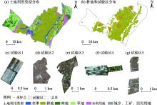
图1
研究区土地利用类型及试验区分布"

表1
土壤样本描述性统计"
| 样本等级(含盐量/g·kg-1) | 样本数量/个 | 含盐量/g·kg-1 | 变异系数/% | ||
|---|---|---|---|---|---|
| 平均值 | 最大值 | 最小值 | |||
| 非盐渍化(<1) | 15 | 0.775 | 0.999 | 0.510 | 16.712 |
| 轻度盐渍化(1~2) | 27 | 1.326 | 1.963 | 1.008 | 19.913 |
| 中度盐渍化(2~4) | 32 | 2.853 | 3.795 | 2.066 | 18.081 |
| 重度盐渍化(4~6) | 15 | 4.966 | 5.909 | 4.060 | 12.385 |
| 盐土(>6) | 15 | 8.208 | 14.231 | 6.145 | 25.133 |
| 总样本 | 104 | 3.251 | 14.231 | 0.510 | 79.154 |
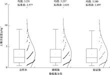
图2
不同数据集土壤样本分布 注:总样本104个,建模集70个,验证集34个;箱线图和正态分布图表示样本分布趋势。"
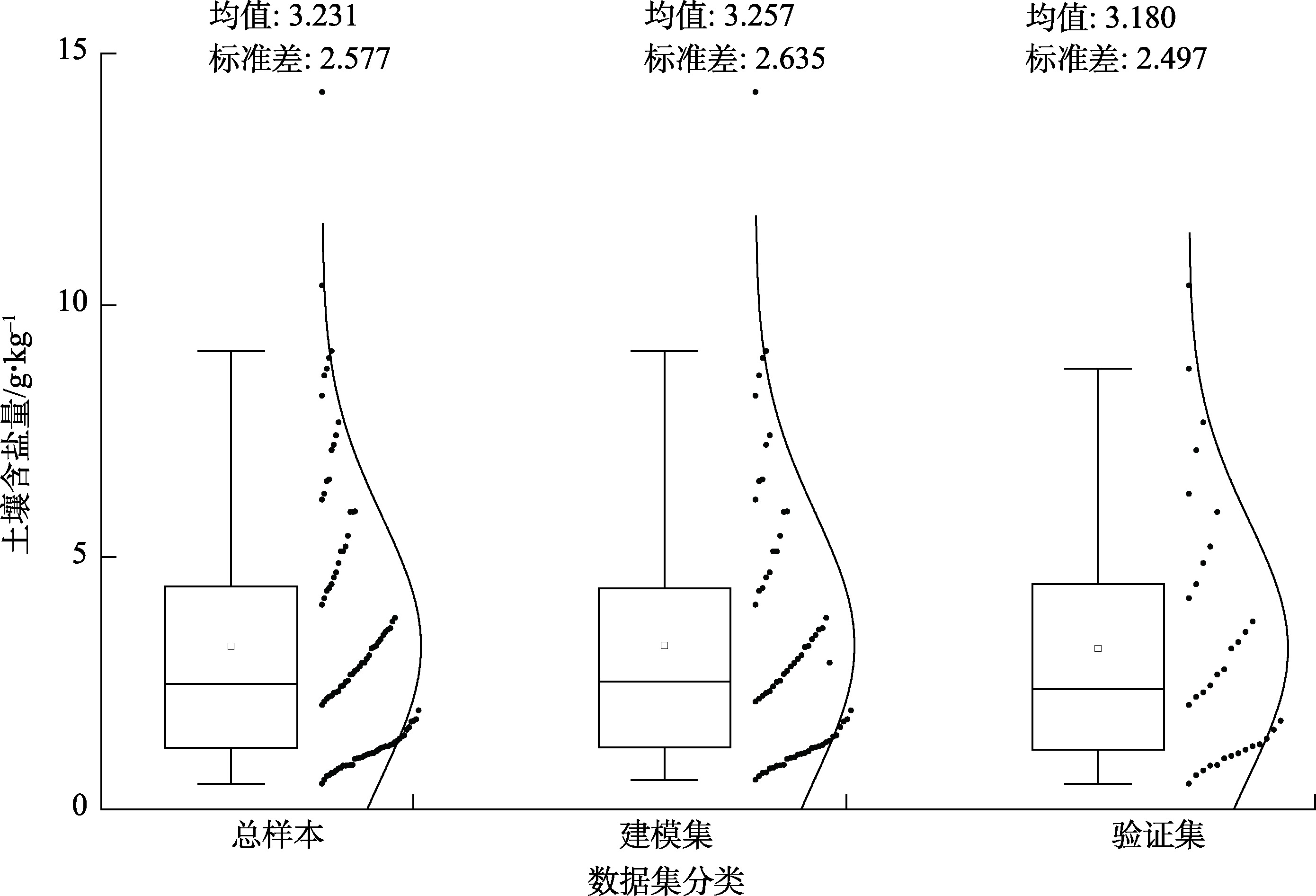
表2
光谱指数计算公式"
| 光谱指数 | 公式 |
|---|---|
| 盐分指数(SI)[ | |
| 盐分指数1(SI1)[ | |
| 盐渍化指数1(S1)[ | Blue/Red |
| 盐渍化指数2(S2)[ | (Blue-Red)/(Blue+Red) |
| 盐渍化指数5(S5)[ | Blue×Red/Green |
| 扩展差值植被指数(EDVI)[ | NIR+SWIR1-Red |
| 扩展比值植被指数(ERVI)[ | (NIR+SWIR1)/Green |
| 大气阻抗植被指数 (ARVI)[ | (NIR-2Red+Blue)/(NIR+2Red-Blue) |
| 冠层盐度响应植被指数 (CRSI)[ | |
| 扩展增强型植被指数 (EEVI)[ |
表3
雷达极化组合指数计算公式"
| 雷达极化组合指数 | 参考文献 | 雷达极化组合指数 | 参考文献 |
|---|---|---|---|
| VV | [ | VV2-VH2 | [ |
| VH | [ | VV2+VH | [ |
| VV-VH | [ | VV2-VH | [ |
| VV+VH | [ | VH2-VV | [ |
| VV2+VH2 | [ | VH2-VV2 | [ |

图3
研究路线 注:VIP、GC分别为变量投影重要性法和灰度关联法;BPNN、SVM、RF分别为反向传播神经网络、支持向量机和随机森林。"


图4
特征变量与土壤含盐量的投影重要性 注:横轴光谱指数和雷达极化组合指数含义同表2、表3所示。下同。"
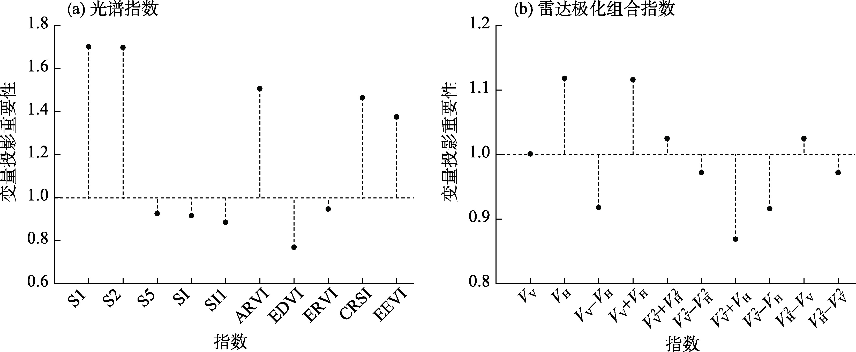
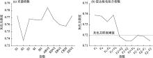
图5
特征变量与土壤含盐量的灰色关联度"

表4
基于单一遥感数据的机器学习模型"
| 变量 | 模型类别 | 建模集 | 验证集 | |||
|---|---|---|---|---|---|---|
| R2 | RMSE | R2 | RMSE | |||
| 光谱指数 | VIP-BPNN | 0.325 | 1.828 | 0.464 | 1.926 | |
| VIP-SVM | 0.552 | 1.487 | 0.476 | 1.840 | ||
| VIP-RF | 0.726 | 1.163 | 0.689 | 1.307 | ||
| GC-BPNN | 0.328 | 1.822 | 0.433 | 1.979 | ||
| GC-SVM | 0.488 | 1.591 | 0.461 | 1.904 | ||
| GC-RF | 0.649 | 1.317 | 0.327 | 2.158 | ||
| 雷达极化组合指数 | VIP-BPNN | 0.228 | 1.954 | 0.291 | 2.214 | |
| VIP-SVM | 0.482 | 1.475 | 0.524 | 1.814 | ||
| VIP-RF | 0.706 | 1.205 | 0.543 | 1.509 | ||
| GC-BPNN | 0.220 | 1.964 | 0.346 | 2.127 | ||
| GC-SVM | 0.509 | 1.440 | 0.356 | 1.910 | ||
| GC-RF | 0.518 | 1.543 | 0.413 | 2.015 | ||
表5
基于多源遥感数据的机器学习模型"
| 变量 | 模型类别 | 建模集 | 验证集 | |||
|---|---|---|---|---|---|---|
| R2 | RMSE | R2 | RMSE | |||
| 光谱指数和雷达极化组合指数 | VIP-BPNN | 0.694 | 1.230 | 0.588 | 1.689 | |
| VIP-SVM | 0.787 | 1.027 | 0.643 | 1.572 | ||
| VIP-RF | 0.791 | 1.016 | 0.780 | 1.132 | ||

图6
不同数据源变量的VIP-RF模型 注:R2为决定系数;RMSE为均方根误差。"
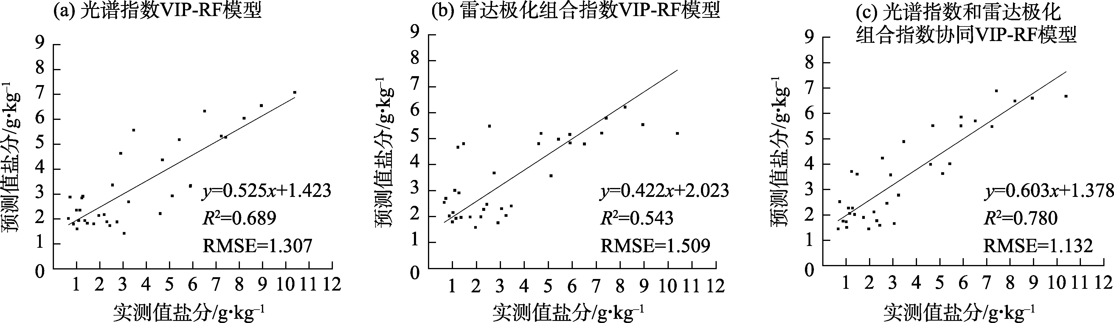
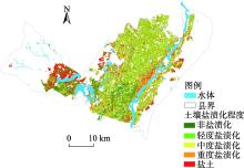
图7
耕地土壤含盐量反演等级分布"

表6
耕地土壤含盐量反演等级统计"
| 盐渍化程度 | 非盐渍化 | 轻度盐渍化 | 中度盐渍化 | 重度盐渍化 | 盐土 |
|---|---|---|---|---|---|
| 像元数/个 | 138897 | 250353 | 353408 | 161882 | 148863 |
| 面积/km2 | 124.95 | 225.18 | 317.73 | 145.60 | 133.86 |
| 占比% | 13.19 | 23.77 | 33.54 | 15.37 | 14.13 |
| [1] | Abdelaziz M E, Abdelsattar M, Abdeldaym E A, et al. Piriformospora indica alters Na+/K+ homeostasis, antioxidant enzymes and LeNHX1 expression of greenhouse tomato grown under salt stress[J]. Scientia Horticulturae, 2019, 256: 108532, doi: 10.1016/j.scienta.2019.05.059. |
| [2] |
Singh A. Soil salinity: A global threat to sustainable development[J]. Soil Use and Management, 2022, 38(1): 39-67.
doi: 10.1111/sum.v38.1 |
| [3] | 李星佑, 张飞, 王筝. 土壤盐渍化遥感监测模型构建方法现状与发展趋势[J]. 自然资源遥感, 2022, 34(4): 11-21. |
| [Li Xingyou, Zhang Fei, Wang Zheng. Present situation and development trend in building remote sensing monitoring models of soil salinization[J]. Remote Sensing for Natural Resources, 2022, 34(4): 11-21.] | |
| [4] | 陈红艳, 赵庚星, 陈敬春, 等. 基于改进植被指数的黄河口区盐渍土盐分遥感反演[J]. 农业工程学报, 2015, 31(5): 107-114. |
| [Chen Hongyan, Zhao Gengxing, Chen Jingchun, et al. Remote sensing inversion of saline soil salinity based on modified vegetation index in estuary area of Yellow River[J]. Transactions of the Chinese Society of Agricultural Engineering, 2015, 31(5): 107-114.] | |
| [5] |
Wang J Z, Ding J L, Ma X K, et al. Capability of Sentinel-2 MSI data for monitoring and mapping of soil salinity in dry and wet seasons in the Ebinur Lake region, Xinjiang, China[J]. Geoderma, 2019, 353: 172-187.
doi: 10.1016/j.geoderma.2019.06.040 |
| [6] | 赵孟银. 遥感影像去云方法研究[D]. 天津: 天津科技大学, 2016. |
| [Zhao Mengyin. Study of clouds removal methods on remote sensing images[D]. Tianjin: Tianjin University of Science and Technology, 2016.] | |
| [7] | 李彪, 王耀强. 土壤盐渍化雷达反演模拟研究[J]. 干旱区资源与环境, 2015, 29(8): 180-184. |
| [Li Biao, Wang Yaoqiang. Radar inversion and simulation of salty soil salinization[J]. Journal of Arid Land Resources and Environment, 2015, 29(8): 180-184.] | |
| [8] | 马驰. 基于Sentinel 1双极化雷达影像的土壤含盐量反演[J]. 农业工程学报, 2018, 34(2):153-158. |
| [Ma Chi. Quantitative retrieval of soil salt content based on Sentinel-1 dual polarization radar image[J]. Transactions of the Chinese Society of Agricultural Engineering, 2018, 34(2): 153-158.] | |
| [9] | 张智韬, 杜瑜燕, 劳聪聪, 等. 基于雷达遥感的不同深度土壤含盐量反演模型[J]. 农业机械学报, 2020, 51(10): 243-251. |
| [Zhang Zhitao, Du Yuyan, Lao Congcong, et al. Inversion model of soil salt content in different depths based on radar remote sensing[J]. Transactions of the Chinese Society for Agricultural Machinery, 2020, 51(10): 243-251.] | |
| [10] | 肖森天, 依力亚斯江·努尔麦麦提, 努尔比耶·穆合塔尔, 等. 基于光学和雷达多源遥感的于田绿洲土壤盐渍化时空分析[J]. 干旱区研究, 2023, 40(1): 59-68. |
| [Xiao Sentian, Nurmemet Ilyas, Muhetaer Nuerbiye, et al. Spatial and temporal analysis of soil salinity in Yutian Oasis by combined optical and radar multi-source remote sensing[J]. Arid Zone Research, 2023, 40(1): 59-68.] | |
| [11] | 王飞, 丁建丽, 魏阳, 等. 基于Landsat系列数据的盐分指数和植被指数对土壤盐度变异性的响应分析——以新疆天山南北典型绿洲为例[J]. 生态学报, 2017, 37(15): 5007-5022. |
| [Wang Fei, Ding Jianli, Wei Yang, et al. Sensitivity analysis of soil salinity and vegetation indices to detect soil salinity variation by using Landsat series images: Applications in different oases in Xinjiang, China[J]. Acta Ecologica Sinica, 2017, 37(15): 5007-5022.] | |
| [12] | 王海峰. 基于高光谱遥感的土壤水盐监测模型研究[D]. 咸阳: 西北农林科技大学, 2019. |
| [Wang Haifeng. Hyperspectral remote sensing based models for soil moisture and salinity prediction[D]. Xianyang: Northwest A & F University, 2019.] | |
| [13] | 刘恩, 王军涛, 常步辉, 等. 小开河引黄灌区土壤盐渍化定量遥感反演[J]. 中国农村水利水电, 2019(12): 20-24. |
| [Liu En, Wang Juntao, Chang Buhui, et al. Quantitative remote sensing inversion of soil salinization in Xiaokaihe Yellow River irrigation district[J]. China Rural and Hydropower, 2019(12): 20-24.] | |
| [14] | 刘亚秋. 黄河三角洲盐渍土盐分及组分定量光谱估测研究[D]. 泰安: 山东农业大学, 2017. |
| [Liu Yaqiu. Quantitative estimation of soil salinity and its composition based on spectra in Yellow River Delta[D]. Tai'an: Shandong Agricultural University, 2017.] | |
| [15] | 曹肖奕, 丁建丽, 葛翔宇, 等. 基于不同卫星光谱模拟的土壤电导率估算研究[J]. 干旱区地理, 2020, 43(1): 172-181. |
| [Cao Xiaoyi, Ding Jianli, Ge Xiangyu, et al. Estimation of soil conductivity based on spectral simulation of different satellites[J]. Arid Land Geography, 2020, 43(1): 172-181.] | |
| [16] | 魏慧敏, 贾科利, 张旭, 等. 基于机器学习和多光谱遥感的银川平原土壤盐分预测[J]. 干旱区地理, 2023, 46(1): 103-114. |
| [Wei Huimin, Jia Keli, Zhang Xu, et al. Prediction of soil salinity based on machine learning and multispectral remote sensing in Yinchuan Plain[J]. Arid Land Geography, 2023, 46(1): 103-114.] | |
| [17] | 李小雨, 贾科利, 魏慧敏, 等. 基于随机森林算法的土壤含盐量预测[J]. 干旱区研究, 2023, 40(8): 1258-1267. |
| [Li Xiaoyu, Jia Keli, Wei Huimin, et al. Prediction of soil salt content based on random forest algorithm[J]. Arid Zone Research, 2023, 40(8): 1258-1267.] | |
| [18] |
Khan N M, Rastoskuev V V, Sato Y, et al. Assessment of hydrosaline land degradation by using a simple approach of remote sensing indicators[J]. Agricultural Water Management, 2005, 77(1-3): 96-109.
doi: 10.1016/j.agwat.2004.09.038 |
| [19] | 樊彦国, 张维康, 刘敬一. 基于植被指数-盐分指数特征空间的黄河三角洲盐渍化遥感监测研究[J]. 山东农业科学, 2016, 48(5): 137-141. |
| [Fan Yanguo, Zhang Weikang, Liu Jingyi. Remote sensing monitoring model of soil salinization in the Yellow River Delta zone based on vegetation index-salt index feature space[J]. Shandong Agricultural Sciences, 2016, 48(5): 137-141.] | |
| [20] | Sahana M, Rehman S, Patel P P, et al. Assessing the degree of soil salinity in the Indian Sundarban Biosphere Reserve using measured soil electrical conductivity and remote sensing data-derived salinity indices[J]. Arabian Journal of Geosciences, 2020, 13(24): 1289, doi: 10.1007/s12517-020-06310-w. |
| [21] |
Nguyen K A, Liou Y A, Tran H P, et al. Soil salinity assessment by using near-infrared channel and vegetation soil salinity index derived from Landsat 8 OLI data: A case study in the Tra Vinh Province, Mekong Delta, Vietnam[J]. Progress in Earth and Planetary Science, 2020, 7(1): 1-16.
doi: 10.1186/s40645-019-0311-0 |
| [22] | 孙亚楠, 李仙岳, 史海滨, 等. 基于多源数据融合的盐分遥感反演与季节差异性研究[J]. 农业机械学报, 2020, 51(6): 169-180. |
| [Sun Ya’nan, Li Xianyue, Shi Haibin, et al. Remote sensing inversion of soil salinity and seasonal difference analysis based on multi-source data fusion[J]. Transactions of the Chinese Society for Agricultural Machinery, 2020, 51(6): 169-180.] | |
| [23] |
Brunner P, Li H T, Kinzelbach W, et al. Generating soil electrical conductivity maps at regional level by integrating measurements on the ground and remote sensing data[J]. International Journal of Remote Sensing, 2007, 28(15-16): 3341-3361.
doi: 10.1080/01431160600928641 |
| [24] | 何宝忠, 丁建丽, 刘博华, 等. 渭库绿洲土壤盐渍化时空变化特征[J]. 林业科学, 2019, 55(9): 185-196. |
| [He Baozhong, Ding Jianli, Liu Bohua, et al. Spatiotemporal variation of soil salinization in Weigan-Kuqa River delta oasis[J]. Scientia Silvae Sinicae, 2019, 55(9): 185-196.] | |
| [25] | 郭晓静. 内蒙古河套灌区冻融期土壤盐分的多极化雷达响应分析[D]. 呼和浩特: 内蒙古农业大学, 2014. |
| [Guo Xiaojing. Response analysis of multi-polarization radar on freeze-thaw period soil salt in Inner Mongolia Hetao irrigation district[D]. Hohhot: Inner Mongolia Agricultural University, 2014.] | |
| [26] | 于海云, 王志军, 李彪, 等. 内蒙古河套灌区融解期土壤盐分多极化雷达响应分析[J]. 长江科学院院报, 2015, 32(11): 19-24. |
| [Yu Haiyun, Wang Zhijun, Li Biao, et al. Response analysis of multi-polarization radar on soil salt during melting period in Hetao irrigation district of Inner Mongolia[J]. Journal of Yangtze River Scientific Research Institute, 2015, 32(11): 19-24.] | |
| [27] | 李生勇, 霍轶珍, 王海霞. 内蒙古自治区河套灌区冻结期土壤盐分的多极化雷达响应分析[J]. 江苏农业科学, 2016, 44(3): 348-352. |
| [Li Shengyong, Huo Yizhen, Wang Haixia. Response analysis of multi-polarization radaron soil salinity during freezing period in Hetao irrigation district of Inner Mongolia Autonomous Region[J]. Jiangsu Agricultural Sciences, 2016, 44(3): 348-352.] | |
| [28] |
Oussama A, Elabadi F, Platikanov S, et al. Detection of olive oil adulteration using FT-IR spectroscopy and PLS with variable importance of projection (VIP) scores[J]. Journal of the American Oil Chemists Society, 2012, 89(10): 1807-1812.
doi: 10.1007/s11746-012-2091-1 |
| [29] | Maimaitiyiming M, Ghulam A, Bozzolo A, et al. Early detection of plant physiological responses to different levels of water stress using reflectance spectroscopy[J]. Remote Sensing, 2017, 9(7): 745, doi: 10.3390/rs9070745. |
| [30] |
刘思峰, 蔡华, 杨英杰, 等. 灰色关联分析模型研究进展[J]. 系统工程理论与实践, 2013, 33(8): 2041-2046.
doi: 10.12011/1000-6788(2013)8-2041 |
| [Liu Sifeng, Cai Hua, Yang Yingjie, et al. Advance in grey incidence analysis modelling[J]. Systems Engineering-Theory and Practice, 2013, 33(8): 2041-2046.] | |
| [31] |
杨淑娥, 黄礼. 基于BP神经网络的上市公司财务预警模型[J]. 系统工程理论与实践, 2005, 25(1): 12-18.
doi: 10.12011/1000-6788(2005)1-12 |
| [Yang Shu'e, Huang Li. Financial crisis warning model based on BP neural network[J]. Systems Engineering-Theory & Practice, 2005, 25(1): 12-18.] | |
| [32] | 赵亚琴. 基于模糊神经网络的火灾识别算法[J]. 计算机仿真, 2015, 32(2): 369-373. |
| [Zhao Yaqin. Forest fire recognition algorithm based on fuzzy neural network[J]. Computer Simulation, 2015, 32(2): 369-373.] | |
| [33] | 汪海燕, 黎建辉, 杨风雷. 支持向量机理论及算法研究综述[J]. 计算机应用研究, 2014, 31(5): 1281-1286. |
| [Wang Haiyan, Li Jianhui, Yang Fenglei. Overview of support vector machine analysis and algorithm[J]. Application Research of Computers, 2014, 31(5): 1281-1286.] | |
| [34] |
Biau G, Scornet E. A random forest guided tour[J]. Test, 2016, 25(2): 197-227.
doi: 10.1007/s11749-016-0481-7 |
| [35] |
杨练兵, 陈春波, 郑宏伟, 等. 基于优化随机森林回归模型的土壤盐渍化反演[J]. 地球信息科学学报, 2021, 23(9): 1662-1674.
doi: 10.12082/dqxxkx.2021.200711 |
| [Yang Lianbing, Chen Chunbo, Zheng Hongwei, et al. Retrieval of soil salinity content based on optimized random forest regression model[J]. Journal of Geo-information Science, 2021, 23(9): 1662-1674.] | |
| [36] | 余祥伟, 薛东剑. 星载SAR与OLI影像融合方法研究及质量评价[J]. 西华师范大学学报(自然科学版), 2020, 41(1): 98-103. |
| [Yu Xiangwei, Xue Dongjian. Research and quality evaluation of spaceborne SAR and OLI image fusion methods[J]. Journal of China West Normal University (Natural Sciences Edition), 2020, 41(1): 98-103.] | |
| [37] | 姜红, 玉素甫江·如素力, 拜合提尼沙·阿不都克日木, 等. 基于支持向量机回归算法的土壤水分光学与微波遥感协同反演[J]. 地理与地理信息科学, 2017, 33(6): 30-36. |
| [Jiang Hong, Rusuli Yusufujiang, Abudoukerimu Baihetinisha, et al. Soil moisture retrieval by synergizing optical and microwave remote sensing data based on support vector machine regression algorithm[J]. Geography and Geo-information Science, 2017, 33(6): 30-36.] | |
| [38] | 李明亮. 土壤有机质高光谱灰色关联度估测模型研究[D]. 泰安: 山东农业大学, 2017. |
| [Li Mingliang. Study on the grey relation degree estimation on model of soil organic matter based on hyperspectral[D]. Tai'an: Shandong Agricultural University, 2017.] | |
| [39] |
Viscarra Roseel R A, Webster R. Predicting soil properties from the Australian soil visible-near infrared spectroscopic database[J]. European Journal of Soil Science, 2012, 63(6): 848-860.
doi: 10.1111/ejs.2012.63.issue-6 |
| [40] | 张智韬, 魏广飞, 姚志华, 等. 基于无人机多光谱遥感的土壤含盐量反演模型研究[J]. 农业机械学报, 2019, 50(12): 151-160. |
| [Zhang Zhitao, Wei Guangfei, Yao Zhihua, et al. Soil salt inversion model based on UAV multispectral remote sensing[J]. Transactions of the Chinese Society for Agricultural Machinery, 2019, 50(12): 151-160.] | |
| [41] |
Chen B L, Zheng H W, Luo G P, et al. Adaptive estimation of multi-regional soil salinization using extreme gradient boosting with Bayesian TPE optimization[J]. International Journal of Remote Sensing, 2022, 43(3): 778-811.
doi: 10.1080/01431161.2021.2009589 |
| [42] | Wang L Y, Hu P, Zheng H W, et al. Integrative modeling of heterogeneous soil salinity using sparse ground samples and remote sensing images[J]. Geoderma, 2023, 430: 116321, doi: 10.1016/j.geoderma.2022.116321. |
| [43] |
Xu H T, Chen C B, Zheng H W, et al. AGA-SVR-based selection of feature subsets and optimization of parameter in regional soil salinization monitoring[J]. International Journal of Remote Sensing, 2020, 41(12): 4470-4495.
doi: 10.1080/01431161.2020.1718239 |
| [44] | 张旭. 银川平原土壤盐分空间分布及驱动因子研究[D]. 银川: 宁夏大学, 2022. |
| [Zhang Xu. Study on spatial distribution and driving factors of soil salinity in Yinchuan Plain[D]. Yinchuan: Ningxia University, 2022.] | |
| [45] | 杨劲松, 姚荣江, 王相平, 等. 中国盐渍土研究: 历程, 现状与展望[J]. 土壤学报, 2022, 59(1): 10-27. |
| [Yang Jinsong, Yao Rongjiang, Wang Xiangping, et al. Research on salt-affected soils in China: History, status quo and prospect[J]. Acta Pedologica Sinica, 2022, 59(1): 10-27.] |
| [1] | 辛悦, 苏立娟, 郑旭程, 李慧, 衣娜娜, 靳雨晨. 内蒙古冰雹特征及基于机器学习的冰雹识别方法研究[J]. 干旱区地理, 2025, 48(1): 11-19. |
| [2] | 吴一帆, 邢培学, 郑伟伟, 夏显力, 张超正. 粮食产销平衡区耕地非粮化动态演变及分区管控——以陕西省为例[J]. 干旱区地理, 2025, 48(1): 153-167. |
| [3] | 卢泉, 高花彦, 王鹏鹏, 冯啸林, 杨艳霞. 塔里木河流域水-耕地-粮棉系统耦合关系及影响因素分析[J]. 干旱区地理, 2024, 47(5): 820-829. |
| [4] | 薄立明, 尹力, 魏伟, 赵浪, 夏俊楠. 2000—2020年河西走廊国土空间格局演变特征及驱动力分析[J]. 干旱区地理, 2024, 47(5): 885-897. |
| [5] | 李海央, 杨敏. 中国西北农作制区耕地利用“显-隐性”形态耦合协调度研究[J]. 干旱区地理, 2024, 47(11): 1924-1934. |
| [6] | 潘雪, 关宇淇, 潘占东, 刘杰, 蔡立群, 董博, 杜健. 干旱区耕地质量等级时空变化及其评价——以西宁市为例[J]. 干旱区地理, 2023, 46(5): 793-803. |
| [7] | 王新友,王玉娇. 耕地撂荒的文献计量分析:脉络和展望[J]. 干旱区地理, 2023, 46(5): 804-813. |
| [8] | 崔锦涛, 买买提·沙吾提. 基于特征波段选择和机器学习的陆地棉叶片水分估算[J]. 干旱区地理, 2023, 46(11): 1836-1847. |
| [9] | 魏慧敏, 贾科利, 张旭, 张俊华. 基于机器学习和多光谱遥感的银川平原土壤盐分预测[J]. 干旱区地理, 2023, 46(1): 103-114. |
| [10] | 赵爽,丁建丽,韩礼敬,黄帅,葛翔宇. 新疆典型盐渍土微波介电特性响应分析与建模[J]. 干旱区地理, 2022, 45(5): 1534-1546. |
| [11] | 刘旭辉,白云岗,柴仲平,张江辉,丁邦新,江柱. 基于多光谱遥感的典型绿洲棉田春季土壤盐分反演及验证[J]. 干旱区地理, 2022, 45(4): 1165-1175. |
| [12] | 龙小翠,刘京,徐仲炜,尉芳. 陕西渭北旱塬区县域耕地时空变化及其对粮食生产影响[J]. 干旱区地理, 2022, 45(2): 423-434. |
| [13] | 尹瀚民,古丽·加帕尔,于涛,Jeanine UMUHOZA,李旭. 哈萨克斯坦北部小麦遥感估产方法研究[J]. 干旱区地理, 2022, 45(2): 488-498. |
| [14] | 陶泽涪,王世清,孙丕苓,李凯迪,田文,韩潇潇. 中国北方农牧交错带耕地时空分异及驱动因素[J]. 干旱区地理, 2022, 45(1): 153-163. |
| [15] | 胡贵贵,杨粉莉,杨联安,郑玉蓉,王辉,陈卫军,李亚丽. 基于主成分和机器学习的土壤有机质含量空间预测建模[J]. 干旱区地理, 2021, 44(4): 1114-1124. |
|
||