干旱区地理 ›› 2023, Vol. 46 ›› Issue (1): 103-114.doi: 10.12118/j.issn.1000-6060.2022.277
魏慧敏1( ),贾科利1(),张旭1,张俊华2
收稿日期:2022-06-11
修回日期:2022-07-17
出版日期:2023-01-25
发布日期:2023-02-21
通讯作者:
贾科利(1975-),男,博士,教授,主要从事3S与土地利用研究. E-mail: 作者简介:魏慧敏(1998-),女,硕士研究生,主要从事遥感监测与分析研究. E-mail: 基金资助:
WEI Huimin1(),JIA Keli1(),ZHANG Xu1,ZHANG Junhua2
Received:2022-06-11
Revised:2022-07-17
Online:2023-01-25
Published:2023-02-21
摘要:
快速获取区域土壤盐渍化程度信息,对于盐渍化治理与生态环境保护具有重要意义。以银川平原为研究区,以盐分影响因子和盐分指数分别作为输入参数,建立支持向量机(SVM),BP神经网络(BPNN)和贝叶斯神经网络(BNN)3种土壤盐分预测模型,选取最佳模型进行研究区不同深度的土壤盐渍化预测。结果表明:(1) 0~20 cm土壤盐分预测模型中基于影响因子变量组的BNN模型效果最佳,决定系数(R2)为0.618,均方根误差(RMSE)为2.986;20~40 cm土壤盐分预测模型中基于盐分指数变量组的BNN模型效果最佳,R2为0.651,RMSE为1.947;综合对比下,BNN模型的预测效果最好,可用于研究区土壤盐渍化预测。(2) 银川平原主要是以非盐渍化和轻度盐渍化为主,0~20 cm土壤重度盐渍化及盐土共占总面积的11.59%,20~40 cm土壤重度盐渍化及盐土共占总面积的7.04%,20~40 cm土壤盐渍化程度较0~20 cm土壤盐渍化轻。
魏慧敏, 贾科利, 张旭, 张俊华. 基于机器学习和多光谱遥感的银川平原土壤盐分预测[J]. 干旱区地理, 2023, 46(1): 103-114.
WEI Huimin, JIA Keli, ZHANG Xu, ZHANG Junhua. Prediction of soil salinity based on machine learning and multispectral remote sensing in Yinchuan Plain[J]. Arid Land Geography, 2023, 46(1): 103-114.
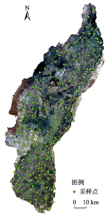
图1
银川平原采样点分布"

表1
银川平原土壤样本统计"
| 深度/cm | 程度 | 含盐量/g·kg-1 | 样本数 | 含盐量均值 /g·kg-1 | 含盐量最大值 /g·kg-1 | 含盐量最小值 /g·kg-1 | 变异系数 /% | 总样本变异 系数/% |
|---|---|---|---|---|---|---|---|---|
| 0~20 | 非盐渍化 | <1 | 75 | 0.510 | 0.983 | 0.097 | 41.295 | 172.327 |
| 轻度盐渍化 | 1~2 | 32 | 1.522 | 1.946 | 1.058 | 18.823 | ||
| 中度盐渍化 | 2~4 | 20 | 2.819 | 3.667 | 2.003 | 20.119 | ||
| 重度盐渍化 | 4~6 | 12 | 4.734 | 5.803 | 4.122 | 11.538 | ||
| 盐土 | >6 | 27 | 15.104 | 43.725 | 6.676 | 59.548 | ||
| 20~40 | 非盐渍化 | <1 | 101 | 0.566 | 0.997 | 0.308 | 30.428 | 132.278 |
| 轻度盐渍化 | 1~2 | 34 | 1.471 | 1.979 | 1.020 | 17.701 | ||
| 中度盐渍化 | 2~4 | 23 | 2.674 | 3.752 | 2.015 | 19.605 | ||
| 重度盐渍化 | 4~6 | 4 | 4.387 | 5.276 | 4.038 | 13.545 | ||
| 盐土 | >6 | 4 | 9.872 | 17.929 | 6.274 | 55.894 |
表2
盐分指数计算公式"
| 盐分指数 | 计算公式 | 参考文献 |
|---|---|---|
| SI-T | 100(Red-NIR) | 刘旭辉等[ |
| NDSI | (Red-NIR)/(Red+NIR) | Amal等[ |
| S1 | Blue/Red | Sahana等[ |
| S2 | (Blue-Red)/(Blue+Red) | Nguyen等[ |
| S3 | (Green×Red)/Blue | Nguyen等[ |
| S4 | 樊彦国等[ | |
| S5 | (Blue×Red)/Green | 孙亚楠等[ |
| S6 | (Red×NIR)/Green | 孙亚楠等[ |
| SI1 | 樊彦国等[ | |
| SI2 | 樊彦国等[ | |
| SI3 | 赵巧珍等[ |
表3
土壤盐渍化影响因子"
| 变量类型 | 参数名称 | 描述 |
|---|---|---|
| 环境变量 | 土壤pH | 土壤酸碱性 |
| 土壤含水率/% | 土壤绝对含水量 | |
| 高程/m | 地区的海拔高度 | |
| 增强植被指数 | 农作物长势和营养信息 | |
| 水体指数 | 地区水体信息 | |
| 地表温度/℃ | 地区土壤温度 | |
| 地下水埋深/m | 地区潜水的埋藏深度 | |
| 地下水矿化度/g·L-1 | 区域潜水中可溶性盐类的质量 | |
| 人为活动变量 | 土地利用强度 | 土地资源的利用效率 |
| 人口密度/人·km-2 | 每平方千米的人口平均数 | |
| 生产总值/元 | 生产活动的最终成果 |
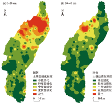
图2
土壤盐分空间分布"

表4
模型参数与土壤盐分的相关性"
| 参数类型 | 参数 | 与0~20 cm土壤相关系数(r1) | 与20~40 cm土壤相关系数(r2) |
|---|---|---|---|
| 盐渍化影响因子 | 土壤pH | 0.034 | 0.030 |
| 土壤含水率 | 0.103 | 0.102 | |
| 高程 | -0.253** | -0.114 | |
| 土地利用强度 | -0.403** | -0.255** | |
| 增强植被指数 | -0.580** | -0.311** | |
| 水体指数 | 0.511** | 0.271** | |
| 地表温度 | -0.445** | -0.119** | |
| 地下水埋深 | -0.477** | -0.204** | |
| 地下水矿化度 | 0.768** | 0.254** | |
| 人口密度 | -0.023 | 0.048 | |
| 生产总值 | -0.173* | -0.025 | |
| 盐分指数 | S1 | 0.492** | 0.402** |
| S2 | 0.480** | 0.388** | |
| S3 | -0.230** | -0.054 | |
| S4 | 0.049 | 0.210** | |
| S5 | 0.067 | 0.229** | |
| S6 | -0.309** | -0.093 | |
| SI1 | -0.032 | 0.136 | |
| SI2 | -0.130* | 0.069 | |
| SI3 | -0.043 | 0.127* | |
| NDSI | 0.325** | 0.204** | |
| SI-T | 0.347** | 0.182* |
表5
基于不同变量组的机器学习模型"
| 变量组 | 模型类别 | 建模集(n=110) | 验证集(n=56) | |||
|---|---|---|---|---|---|---|
| R2 | RMSE | R2 | RSME | |||
| 影响因子组 (0~20 cm) | SVM | 0.766 | 3.397 | 0.542 | 3.266 | |
| BPNN | 0.773 | 2.638 | 0.608 | 3.081 | ||
| BNN | 0.797 | 2.751 | 0.618 | 2.986 | ||
| 盐分指数组 (0~20 cm) | SVM | 0.319 | 5.945 | 0.213 | 4.155 | |
| BPNN | 0.311 | 5.878 | 0.206 | 4.405 | ||
| BNN | 0.336 | 5.715 | 0.250 | 3.890 | ||
| 影响因子组 (20~40 cm) | SVM | 0.368 | 1.327 | 0.221 | 2.401 | |
| BPNN | 0.314 | 1.353 | 0.331 | 2.221 | ||
| BNN | 0.425 | 1.076 | 0.486 | 2.026 | ||
| 盐分指数组 (20~40 cm) | SVM | 0.440 | 1.032 | 0.436 | 2.079 | |
| BPNN | 0.348 | 1.086 | 0.545 | 2.033 | ||
| BNN | 0.442 | 1.006 | 0.651 | 1.947 | ||
图3
土壤盐分与模型预测值的散点图"
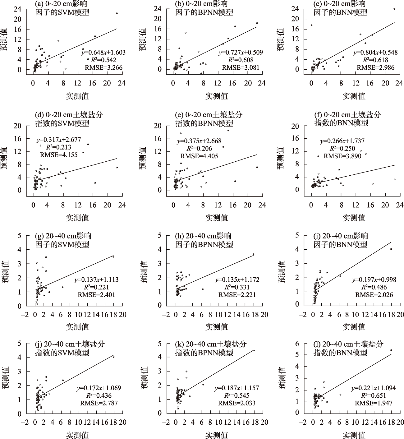
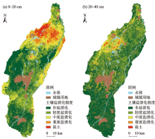
图4
土壤含盐量预测等级分布"

表6
实测插值与预测像元统计"
| 深度/cm | 盐渍化程度 | 实测插值像元数 | 预测和实测插值相同等级个数 | 相同率/% |
|---|---|---|---|---|
| 0~20 | 非盐渍化 | 3922460 | 3221641 | 82.13 |
| 轻度盐渍化 | 1925470 | 1409137 | 73.18 | |
| 中度盐渍化 | 779011 | 648843 | 83.29 | |
| 重度盐渍化 | 764161 | 602002 | 78.78 | |
| 盐土 | 507095 | 434657 | 85.72 | |
| 20~40 | 非盐渍化 | 4279527 | 3613169 | 84.43 |
| 轻度盐渍化 | 2413166 | 2046062 | 84.79 | |
| 中度盐渍化 | 722601 | 538546 | 74.53 | |
| 重度盐渍化 | 311423 | 274697 | 88.21 | |
| 盐土 | 171493 | 144933 | 84.51 |
| [1] | 杨真, 王宝山. 中国盐渍土资源现状及改良利用对策[J]. 山东农业科学, 2015, 47(4): 125-130. |
| [Yang Zhen, Wang Baoshan. Present status of saline soil resources and countermeasures for improvement and utilization in China[J]. Shandong Agricultural Sciences, 2015, 47(4): 125-130.] | |
| [2] | 翁永玲, 戚浩平, 方洪宾, 等. 基于PLSR方法的青海茶卡-共和盆地土壤盐分高光谱遥感反演[J]. 土壤学报, 2010, 47(6): 1255-1263. |
| [Weng Yongling, Qi Haoping, Fang Hongbin, et al. PLSR-based hyperspectral remote sensing retrieval of soil salinity of Chaka-Gonghe Basin in Qinghai Province[J]. Acta Pedologica Sinica, 2010, 47(6): 1255-1263.] | |
| [3] | 王爽, 丁建丽, 王璐, 等. 基于地表光谱建模的区域土壤盐渍化遥感监测研究[J]. 干旱区地理, 2016, 39(1): 190-198. |
| [Wang Shuang, Ding Jianli, Wang Lu, et al. Remote sensing monitoring of soil salinization based on surface spectral modeling[J]. Arid Land Geography, 2016, 39(1): 190-198.] | |
| [4] | El-Horiny M M. Mapping and monitoring of soil salinization using remote sensing and regression techniques: A case study in the Bahariya depression, western desert, Egypt[C]// 2019 IEEE International Geoscience and Remote Sensing Symposium. Yokohama: Institute of Electrical and Electronic Engineers, 2019. |
| [5] | 陈红艳, 赵庚星, 陈敬春, 等. 基于改进植被指数的黄河口区盐渍土盐分遥感反演[J]. 农业工程学报, 2015, 31(5): 107-114. |
| [Chen Hongyan, Zhao Gengxing, Chen Jingchun, et al. Remote sensing inversion of saline soil salinity based on modified vegetation index in estuary area of Yellow River[J]. Transactions of the Chinese Society of Agricultural Engineering, 2015, 31(5): 107-114.] | |
| [6] | 徐红涛, 陈春波, 郑宏伟, 等. 集成建模变量优选和参数学习的SVR盐渍化监测[J]. 遥感技术与应用, 2021, 36(1): 176-186. |
| [Xu Hongtao, Chen Chunbo, Zheng Hongwei, et al. SVR salinization monitoring based on integrated feature subset selection and model parameter learning[J]. Remote Sensing Technology and Application, 2021, 36(1): 176-186.] | |
| [7] |
姜红, 玉素甫江·如素力, 热伊莱·卡得尔, 等. 基于神经网络模型的干旱区绿洲土壤盐渍化评价分析[J]. 地球信息科学学报, 2017, 19(7): 983-993.
doi: 10.3724/SP.J.1047.2017.00983 |
|
[Jiang Hong, Rusuli Yusufujiang, Kadeer Reyilai, et al. Evaluation and analysis of soil salinization in the arid zones based on neural network model[J]. Journal of Geo-information Science, 2017, 19(7): 983-993.]
doi: 10.3724/SP.J.1047.2017.00983 |
|
| [8] | 马国林, 丁建丽, 韩礼敬, 等. 基于变量优选与机器学习的干旱区湿地土壤盐渍化数字制图[J]. 农业工程学报, 2020, 36(19): 124-131. |
| [Ma Guolin, Ding Jianli, Han Lijing, et al. Digital mapping of soil salinization in arid area wetland based on variable optimized selection and machine learning[J]. Transactions of the Chinese Society of Agricultural Engineering, 2020, 36(19): 124-131.] | |
| [9] | 杨厚翔, 雷国平, 徐秋, 等. 基于危险度与风险格局的土地盐碱化监测区优先级评价[J]. 农业工程学报, 2019, 35(7): 238-246. |
| [Yang Houxiang, Lei Guoping, Xu Qiu, et al. Priority evaluation of land salinization monitoring area based on danger degree and risk pattern[J]. Transactions of the Chinese Society of Agricultural Engineering, 2019, 35(7): 238-246.] | |
| [10] | 刘全明, 成秋明, 王学, 等. 河套灌区土壤盐渍化微波雷达反演[J]. 农业工程学报, 2016, 32(16): 109-114. |
| [Liu Quanming, Cheng Qiuming, Wang Xue, et al. Soil salinity inversion in Hetao irrigation district using microwave radar[J]. Transactions of the Chinese Society of Agricultural Engineering, 2016, 32(16): 109-114.] | |
| [11] | 杨练兵, 郑宏伟, 罗格平, 等. 基于遗传算法优化BP神经网络的土壤盐渍化反演[J]. 地理与地理信息科学, 2021, 37(2): 12-21, 37. |
| [Yang Lianbing, Zheng Hongwei, Luo Geping, et al. Retrieval of soil salinity content based on BP neural network optimized by genetic algorithm[J]. Geography and Geo-information Science, 2021, 37(2): 12-21, 37.] | |
| [12] | 章龙管, 刘绥美, 李开富, 等. 基于故障树与贝叶斯网络的地铁盾构施工风险预测[J]. 现代隧道技术, 2021, 58(5): 21-29, 55. |
| [Zhang Longguan, Liu Suimei, Li Kaifu, et al. Prediction of shield construction risks in subway tunneling based on fault tree and Bayesian network[J]. Modern Tunneling Technology, 2021, 58(5): 21-29, 55.] | |
| [13] | 毕春光, 王金龙, 胡楠, 等. 基于贝叶斯神经网络的玉米病害预警模型[J]. 吉林农业大学学报, 2021, 43(2): 189-195. |
| [Bi Chunguang, Wang Jinlong, Hu Nan, et al. A Bayesian neural network-based early warning model for maize diseases[J]. Journal of Jilin Agricultural University, 2021, 43(2): 189-195.] | |
| [14] | 靳晓辉, 樊玉苗, 段浩, 等. 银川平原地下水位对黄河流域水量统一调度的时空响应分析[J]. 水资源与水工程学报, 2021, 32(4): 45-51. |
| [Jin Xiaohui, Fan Yumiao, Duan Hao, et al. Temporal and spatial response of groundwater depth in Yinchuan Plain to the integrated water regulation of the Yellow River[J]. Journal of Water Resources and Water Engineering, 2021, 32(4): 45-51.] | |
| [15] | 曹肖奕, 丁建丽, 葛翔宇, 等. 基于不同卫星光谱模拟的土壤电导率估算研究[J]. 干旱区地理, 2020, 43(1): 172-181. |
| [Cao Xiaoyi, Ding Jianli, Ge Xiangyu, et al. Estimation of soil conductivity based on spectral simulation of different satellites[J]. Arid Land Geography, 2020, 43(1): 172-181.] | |
| [16] | 贾萍萍, 尚天浩, 张俊华, 等. 利用多源光谱信息反演宁夏银北地区干湿季土壤含盐量[J]. 农业工程学报, 2020, 36(17): 125-134. |
| [Jia Pingping, Shang Tianhao, Zhang Junhua, et al. Inversion of soil salinity in dry and wet seasons based on multi-source spectral data in Yinbei area of Ningxia, China[J]. Transactions of the Chinese Society of Agricultural Engineering, 2020, 36(17): 125-134.] | |
| [17] | 武丹, 贾科利, 张晓东, 等. 基于异质SVM神经网络的土壤盐渍化灾害预测模型[J]. 水文地质工程地质, 2018, 45(5): 143-149, 157. |
| [Wu Dan, Jia Keli, Zhang Xiaodong, et al. Soil salinization disaster prediction model based on heterogeneous SVM neural network[J]. Hydrogeology & Engineering Geology, 2018, 45(5): 143-149, 157.] | |
| [18] | 张智韬, 魏广飞, 姚志华, 等. 基于无人机多光谱遥感的土壤含盐量反演模型研究[J]. 农业机械学报, 2019, 50(12): 151-160. |
| [Zhang Zhitao, Wei Guangfei, Yao Zhihua, et al. Soil salt inversion model based on UAV multispectral remote sensing[J]. Transactions of the Chinese Society for Agricultural Machinery, 2019, 50(12): 151-160.] | |
| [19] | 刘旭辉, 白云岗, 柴仲平, 等. 基于多光谱遥感的典型绿洲棉田春季土壤盐分反演及验证[J]. 干旱区地理, 2022, 45(4): 1165-1175. |
| [Liu Xuhui, Bai Yungang, Cai Zhongping, et al. Inversion and validation of soil salinity based on multispectral remote sensing in typical oasis cotton field in spring[J]. Arid Land Geography, 2022, 45(4): 1165-1175.] | |
| [20] | Amal A, Lalit K, Youself Y A. Assessing soil salinity using soil salinity and vegetation indices derived from IKONOS high-spatial resolution imageries: Applications in a date palm dominated region[J]. Geoderma, 2014, 230- 231(7): 1-8. |
| [21] | Sahana M, Rehman S, Patel P P, et al. Assessing the degree of soil salinity in the Indian Sundarban Biosphere Reserve using measured soil electrical conductivity and remote sensing data-derived salinity indices[J]. Arabian Journal of Geosciences, 2020, 13(24): 1289, doi: s12517-020-06310-w. |
| [22] |
Nguyen K A, Liou Y A, Tran H P, et al. Soil salinity assessment by using near-infrared channel and vegetation soil salinity index derived from Landsat 8 OLI data: A case study in the Tra Vinh Province, Mekong Delta, Vietnam[J]. Progress in Earth and Planetary Science, 2020, 7(1): 1-16.
doi: 10.1186/s40645-019-0311-0 |
| [23] | 樊彦国, 张维康, 刘敬一. 基于植被指数-盐分指数特征空间的黄河三角洲盐渍化遥感监测研究[J]. 山东农业科学, 2016, 48(5): 137-141. |
| [Fan Yanguo, Zhang Weikang, Liu Jingyi. Remote sensing monitoring model of soil salinization in the Yellow River Delta Zone based on vegetation index-salt index feature space[J]. Shandong Agricultural Sciences, 2016, 48(5): 137-141.] | |
| [24] | 孙亚楠, 李仙岳, 史海滨, 等. 基于多源数据融合的盐分遥感反演与季节差异性研究[J]. 农业机械学报, 2020, 51(6): 169-180. |
| [Sun Ya’nan, Li Xianyue, Shi Haibin, et al. Remote sensing inversion of soil salinity and seasonal difference analysis based on multi-source data fusion[J]. Transactions of the Chinese Society for Agricultural Machinery, 2020, 51(6): 169-180.] | |
| [25] | 赵巧珍, 丁建丽, 韩礼敬, 等. MODIS和Landsat时空融合影像在土壤盐渍化监测中的适用性研究——以渭干河-库车河三角洲绿洲为例[J]. 干旱区地理, 2022, 45(4): 1155-1164. |
| [Zhao Qiaozhen, Ding Jianli, Han Lijing, et al. Exploring the application of MODIS and Landsat spatiotemporal fusion images in soil salinization: A case of Weigan River-Kuqa River Delta Oasis[J]. Arid Land Geography, 2022, 45(4): 1155-1164.] | |
| [26] | 赖宁, 李新国, 阿斯耶姆·图尔迪, 等. 开都河流域下游绿洲土壤盐渍化时空变化及其成因分析[J]. 干旱区资源与环境, 2013, 27(12): 66-73. |
| [Lai Ning, Li Xinguo, Tuerdi Asiyemu, et al. Analysis of tempo-spatial dynamic change and the cause of soil salinization in the oasis of the lower reaches of Kaidu River Basin[J]. Journal of Arid Land Resources and Environment, 2013, 27(12): 66-73.] | |
| [27] |
庄庆威, 吴世新, 杨怡, 等. 近10年新疆不同程度盐渍化耕地的时空变化特征[J]. 中国科学院大学学报, 2021, 38(3): 341-349.
doi: 10.7523/j.issn.2095-6134.2021.03.007 |
|
[Zhuang Qingwei, Wu Shixin, Yang Yi, et al. Spatiotemporal characteristics of different degrees of salinized cultivated land in Xinjiang in the recent ten years[J]. Journal of University of Chinese Academy of Sciences, 2021, 38(3): 341-349.]
doi: 10.7523/j.issn.2095-6134.2021.03.007 |
|
| [28] | 庄大方, 刘纪远. 中国土地利用程度的区域分异模型研究[J]. 自然资源学报, 1997, 12(2): 10-16. |
| [Zhuang Dafang, Liu Jiyuan. Study on the model of regional differentiation of land use degree in China[J]. Journal of Natural Resources, 1997, 12(2): 10-16.] | |
| [29] | 汪海燕, 黎建辉, 杨风雷. 支持向量机理论及算法研究综述[J]. 计算机应用研究, 2014, 31(5): 1281-1286. |
| [Wang Haiyan, Li Jianhui, Yang Fenglei. Overview of support vector machine analysis and algorithm[J]. Application Research of Computers, 2014, 31(5): 1281-1286.] | |
| [30] |
杨淑娥, 黄礼. 基于BP神经网络的上市公司财务预警模型[J]. 系统工程理论与实践, 2005, 25(1): 12-18, 26.
doi: 10.12011/1000-6788(2005)1-12 |
|
[Yang Shu’e, Huang Li. Financial crisis warning model based on BP neural network[J]. Systems Engineering-Theory & Practice, 2005, 25(1): 12-18, 26.]
doi: 10.12011/1000-6788(2005)1-12 |
|
| [31] | 赵亚琴. 基于模糊神经网络的火灾识别算法[J]. 计算机仿真, 2015, 32(2): 369-373. |
| [Zhao Yaqin. Forest fire recognition algorithm based on fuzzy neural network[J]. Computer Simulation, 2015, 32(2): 369-373.] | |
| [32] | 宿嘉颖. 贝叶斯深度网络的不确定性分析[D]. 哈尔滨: 哈尔滨工业大学, 2020. |
| [Su Jiaying. Uncertainty analysis of Bayesian deep network[D]. Harbin:Harbin Institute of Technology, 2020.] | |
| [33] | 孙发友, 蒙祖强. 一种设备状态监测的贝叶斯正则化BP神经网络[J]. 网络安全技术与应用, 2019(10): 48-53. |
| [Sun Fayou, Meng Zuqiang. A Bayesian regularized BP neural network for equipment condition monitoring[J]. Network Security Technology & Application, 2019(10): 48-53.] | |
| [34] | 王子涵, 杨秀芝, 段现银, 等. 基于贝叶斯神经网络的机床热误差建模[J]. 制造技术与机床, 2022(1): 141-145. |
| [Wang Zihan, Yang Xiuzhi, Duan Xianyin, et al. Research on the thermal error modeling of machine tool based on Bayesian neural network[J]. Manufacturing Technology & Machine Tool, 2022(1): 141-145.] | |
| [35] | 杨思存, 车宗贤, 王成宝, 等. 甘肃沿黄灌区土壤盐渍化特征及其成因[J]. 干旱区研究, 2014, 31(1): 57-64. |
| [Yang Sicun, Che Zongxian, Wang Chengbao, et al. Soil salinization and its causes in the irrigated areas along the Yellow River in Gansu Province[J]. Arid Zone Research, 2014, 31(1): 57-64.] | |
| [36] | 苏春利, 纪倩楠, 陶彦臻, 等. 河套灌区西部土壤盐渍化分异特征及其主控因素[J]. 干旱区研究, 2022, 39(3): 916-923. |
| [Su Chunli, Ji Qiannan, Tao Yanzhen, et al. Differentiation characteristics and factors of soil salinization in the west of Hetao Irrigation Area[J]. Arid Zone Research, 2022, 39(3): 916-923.] | |
| [37] | 刘继龙, 刘璐, 马孝义, 等. 不同尺度不同土层土壤盐分的空间变异性研究[J]. 应用基础与工程科学学报, 2018, 26(2): 305-312. |
| [Liu Jilong, Liu Lu, Ma Xiaoyi, et al. Spatial variability of soil salt in different soil layers at different scales[J]. Journal of Basic Science and Engineering, 2018, 26(2): 305-312.] | |
| [38] | 边慧芹, 王雪梅. 基于多光谱影像的干旱区绿洲耕层土壤盐分估算[J]. 干旱区资源与环境, 2022, 36(5): 110-118. |
| [Bian Huiqin, Wang Xuemei. Estimation of soil salinity in cultivated layers of oasis in arid areas based on multispectral images[J]. Journal of Arid Land Resources and Environment, 2022, 36(5): 110-118.] | |
| [39] | 何宝忠, 丁建丽, 刘博华, 等. 渭库绿洲土壤盐渍化时空变化特征[J]. 林业科学, 2019, 55(9): 185-196. |
| [He Baozhong, Ding Jianli, Liu Bohua, et al. Spatiotemporal variation of soil salinization in Weigan-Kuqa River Delta Oasis[J]. Scientia Silvae Sinicae, 2019, 55(9): 185-196.] | |
| [40] | 陈俊英, 姚志华, 张智韬, 等. 大田葵花土壤含盐量无人机遥感反演研究[J]. 农业机械学报, 2020, 51(7): 178-191. |
| [Chen Junying, Yao Zhihua, Zhang Zhitao, et al. UAV remote sensing inversion of soil salinity in field of sunflower[J]. Transactions of the Chinese Society for Agricultural Machinery, 2020, 51(7): 178-191.] | |
| [41] | 王明宽, 莫宏伟, 陈红艳. 基于多光谱影像反演土壤盐分的建模方法研究[J]. 土壤通报, 2016, 47(5): 1036-1041. |
| [Wang Mingkuan, Mo Hongwei, Chen Hongyan. Study on model method of inversion of soil salt based on multispectral image[J]. Chinese Journal of Soil Science, 2016, 47(5): 1036-1041.] | |
| [42] | 杨宁, 崔文轩, 张智韬, 等. 无人机多光谱遥感反演不同深度土壤盐分[J]. 农业工程学报, 2020, 36(22): 13-21. |
| [Yang Ning, Cui Wenxuan, Zhang Zhitao, et al. Soil salinity at different depths using improved spectral index with UAV multispectral remote sensing[J]. Transactions of the Chinese Society of Agricultural Engineering, 2020, 36(22): 13-21.] |
| [1] | 崔锦涛, 买买提·沙吾提. 基于特征波段选择和机器学习的陆地棉叶片水分估算[J]. 干旱区地理, 2023, 46(11): 1836-1847. |
| [2] | 赵爽,丁建丽,韩礼敬,黄帅,葛翔宇. 新疆典型盐渍土微波介电特性响应分析与建模[J]. 干旱区地理, 2022, 45(5): 1534-1546. |
| [3] | 刘旭辉,白云岗,柴仲平,张江辉,丁邦新,江柱. 基于多光谱遥感的典型绿洲棉田春季土壤盐分反演及验证[J]. 干旱区地理, 2022, 45(4): 1165-1175. |
| [4] | 尹瀚民,古丽·加帕尔,于涛,Jeanine UMUHOZA,李旭. 哈萨克斯坦北部小麦遥感估产方法研究[J]. 干旱区地理, 2022, 45(2): 488-498. |
| [5] | 高阳,韩磊,韩永贵,黄晓宇,彭苓,柳利利. 银川平原降水氢氧稳定同位素时间尺度效应及水汽来源[J]. 干旱区地理, 2022, 45(1): 91-102. |
| [6] | 胡贵贵,杨粉莉,杨联安,郑玉蓉,王辉,陈卫军,李亚丽. 基于主成分和机器学习的土壤有机质含量空间预测建模[J]. 干旱区地理, 2021, 44(4): 1114-1124. |
| [7] | 李慧融. 基于反射率和亮度温度的锡林郭勒积雪深度估算[J]. 干旱区地理, 2020, 43(6): 1567-1572. |
|
||