干旱区地理 ›› 2026, Vol. 49 ›› Issue (4): 740-755.doi: 10.12118/j.issn.1000-6060.2025.460 cstr: 32274.14.ALG2025460
包玉斌1( ), 张慧娟1, 杨雪茹1, 王耀宗2, 李樵民1, 王科1, 胡胜3
收稿日期:2025-08-03
修回日期:2025-09-09
出版日期:2026-04-25
发布日期:2026-04-28
作者简介:包玉斌(1988-),男,硕士,工程师,主要从事生态评价与规划研究. E-mail: byb520.cool@163.com
基金资助:
BAO Yubin1(), ZHANG Huijuan1, YANG Xueru1, WANG Yaozong2, LI Qiaomin1, WANG Ke1, HU Sheng3
Received:2025-08-03
Revised:2025-09-09
Published:2026-04-25
Online:2026-04-28
摘要:
准确量化分析陆地生态系统碳汇与时空特征,是促进区域生态碳汇格局优化和低碳可持续发展的基础。基于长时序遥感产品、地形和气象等数据,构建“样地清查-遥感反演-机器学习-线性趋势分析”等融合研究方法,估算了长时序宁夏陆地生态系统碳储量,完成了多视角生态系统碳汇时空分析与诊断分区。结果表明:(1) 2001—2024年宁夏碳储量呈显著上升趋势,年总碳储量和年平均碳储量增加速率分别为256.86×10⁴ t·a-1和0.49 t·hm-2·a-1。(2) 2001—2024年宁夏生态系统碳汇贡献以草地和农田为主,贡献率分别为41.49%和33.43%,农田、草地和森林之间的相互转化,共增加碳汇1093.19×104 t,贡献率为17.31%。(3) 2001—2024年宁夏生态系统碳汇显著增加的面积占比达78.7%,未来暖湿化趋势下,宁夏92.75%的区域碳储量趋于持续增加趋势,碳汇潜力较大。Moran’s I “高-高”值显著区域主要分布在宁南地区,面积占比达25.1%,且呈现上升趋势,是宁夏碳汇的高度优先区。研究结果可为宁夏生态系统管理、土地利用结构优化和“双碳”目标路径探索提供参考。
包玉斌, 张慧娟, 杨雪茹, 王耀宗, 李樵民, 王科, 胡胜. 宁夏生态系统碳汇时空变化及潜力诊断分区[J]. 干旱区地理, 2026, 49(4): 740-755.
BAO Yubin, ZHANG Huijuan, YANG Xueru, WANG Yaozong, LI Qiaomin, WANG Ke, HU Sheng. Spatiotemporal variation and potential zoning diagnosis of ecosystem carbon sinks in Ningxia[J]. Arid Land Geography, 2026, 49(4): 740-755.
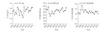
图1
宁夏年均气温、年均降水量和年均干燥度指数的变化趋势"
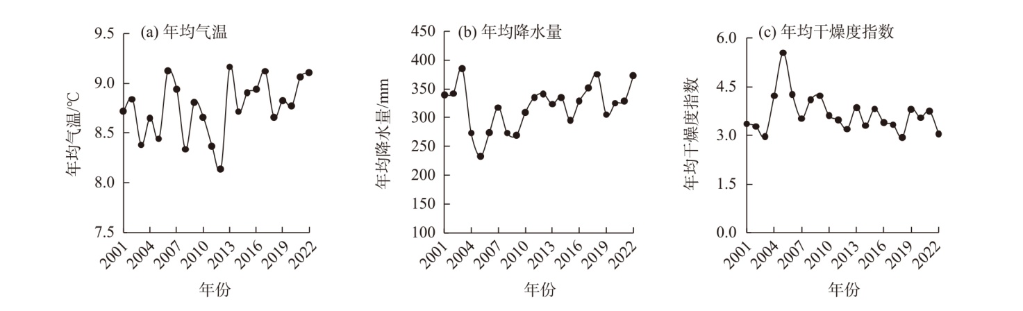
图2
研究区概况 注:基于自然资源部标准地图服务网站审图号为GS(2024)0650号的标准地图制作,底图边界无修改。下同。"

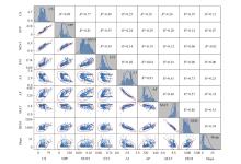
图3
因子相关性分析矩阵 注:CS为生态系统碳储量;NPP为净初级生产力;NDVI为归一化植被指数;EVI为增强植被指数;AI为干燥度指数;AP为年降水量;MAT为年平均气温;DEM为数字高程模型;Slope为坡度;R2为决定系数。下同。"
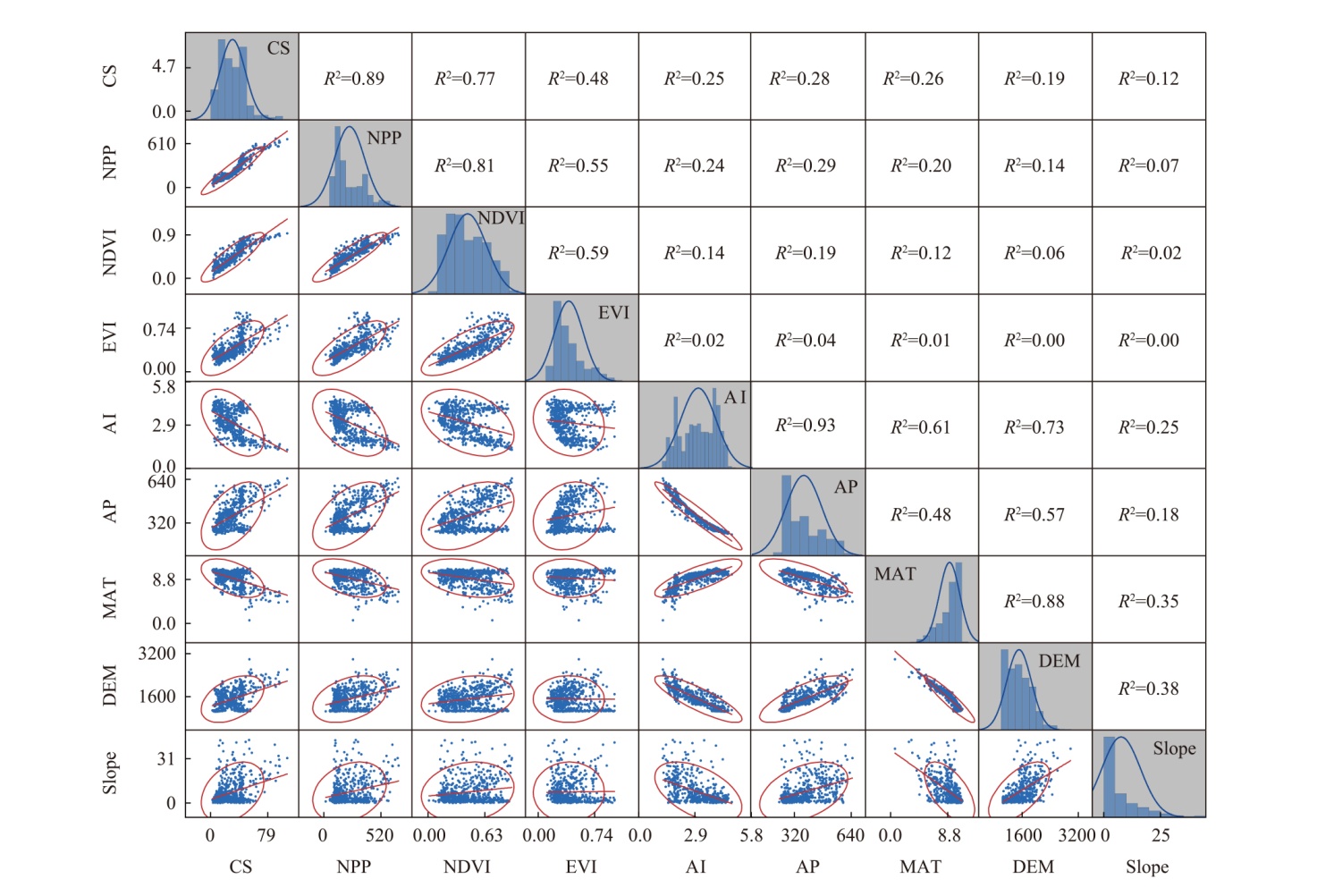
表1
碳汇时空分析方法计算公式"
| 时空分析方法 | 公式 | 基本原理及计算公式 |
|---|---|---|
| Theil-Sen | n为研究年数;Ci和Cj分别为第i年和第j年的碳储量值;β为趋势度,β>0时,表示呈上升趋势,β<0时,表示呈现下降趋势 | |
| Mann-Kendall | S为检验统计量;Z为标准化后的检验统计量;Var(S)为方差;sgn(Cj-Ci)为逻辑判别函数;当 | |
| Hurst指数 | R(t)=max(Xl,t)-min(Xl,t) | 设时间序列长度为N,将其划分为长度为t的连续子区间(通常t取N/2, N/4, …);Xl,n为累计离差; |
| Cv | Cv为时序数据变异系数; | |
| 空间偏相关分析 | Rxy、Rxz、Ryz分别为x,y,z变量之间的相关系数,采用t显著性检验方法;Rxy,z为控制变量z后、x与y之间的偏相关系数; | |
| 莫兰指数空间自相关分析 | I为莫兰指数;S2为方差值;e为研究对象数目;Yp、Yq分别为p、q栅格单元值; |
表2
驱动因素分类依据"
| 驱动因素类型 | 分类依据 | ||
|---|---|---|---|
| RCAR-T | RCAR-P | RCAR-T-P | |
| 气温和降水量共同驱动 | t≤t0.05 | t≤t0.05 | F>F0.05 |
| 降水量驱动 | t>t0.05 | F>F0.05 | |
| 气温驱动 | t>t0.05 | F>F0.05 | |
| 非气候因素驱动 | F≤F0.05 | ||
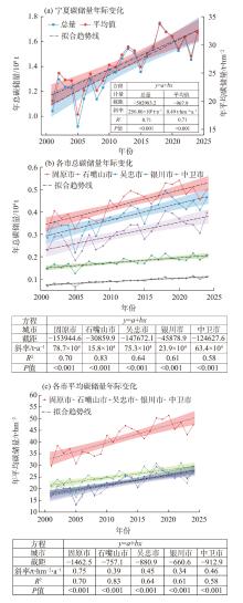
图4
2001—2024年宁夏及各市年平均碳储量及总碳储量变化趋势"
表3
不同生态系统类型及转移变化碳源/汇统计"
| 变化类型 | 生态系统类型 | 面积/km2 | 碳储量变化/104 t | 碳储量斜率/t·hm-2·a-1 | 决定系数(R2) | 贡献率/% |
|---|---|---|---|---|---|---|
| 碳汇 | 森林 | 3433.3 | 372.23 | 0.58 | 0.64 | 5.89 |
| 草地 | 24868.7 | 2621.04 | 0.41 | 0.60 | 41.49 | |
| 农田 | 14685.1 | 2111.83 | 0.57 | 0.77 | 33.43 | |
| 湿地 | 303.0 | 23.80 | 0.31 | 0.81 | 0.38 | |
| 城镇 | 977.2 | 75.24 | 0.35 | 0.78 | 1.19 | |
| 草地→森林 | 363.9 | 50.48 | 0.60 | 0.76 | 0.80 | |
| 草地→农田 | 1614.7 | 342.80 | 0.96 | 0.91 | 5.43 | |
| 草地→湿地 | 180.1 | 4.81 | 0.03 | 0.04 | 0.08 | |
| 农田→森林 | 297.5 | 58.15 | 0.79 | 0.73 | 0.92 | |
| 农田→草地 | 3839.1 | 641.76 | 0.68 | 0.66 | 10.16 | |
| 湿地→农田 | 68.9 | 13.03 | 0.83 | 0.85 | 0.21 | |
| 城镇→草地 | 23.8 | 2.45 | 0.41 | 0.75 | 0.04 | |
| 碳源 | 草地→城镇 | 725.1 | -50.97 | -0.25 | 0.56 | 62.20 |
| 农田→城镇 | 568.6 | -24.69 | -0.26 | 0.37 | 30.13 | |
| 农田→湿地 | 137.0 | -5.52 | -0.34 | 0.56 | 6.74 | |
| 森林→城镇 | 15.7 | -0.74 | -0.15 | 0.16 | 0.90 | |
| 湿地→城镇 | 9.1 | -0.03 | -0.07 | 0.04 | 0.03 |
图5
2001—2024年宁夏碳储量变化显著性空间分布"
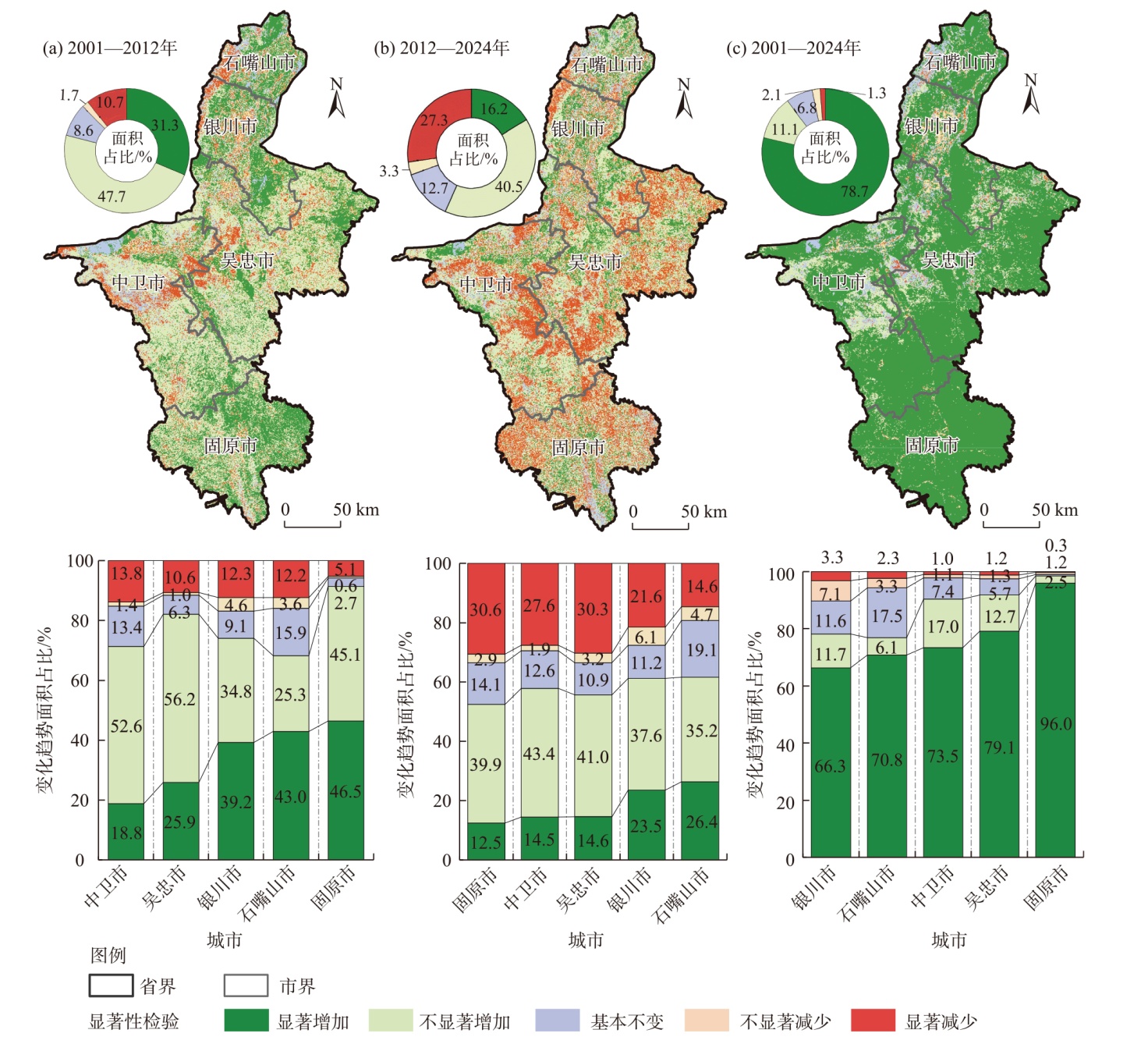
图6
宁夏碳储量变异系数空间分布"
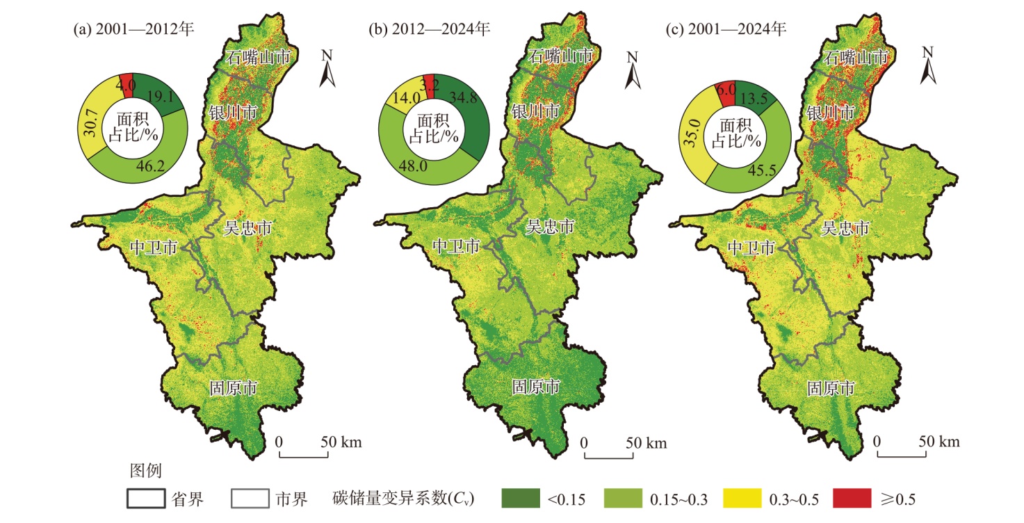
图7
宁夏碳储量未来变化趋势空间分布"

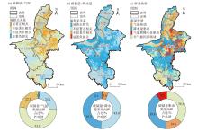
图8
宁夏碳储量变化与气候因素相关性及驱动类型"
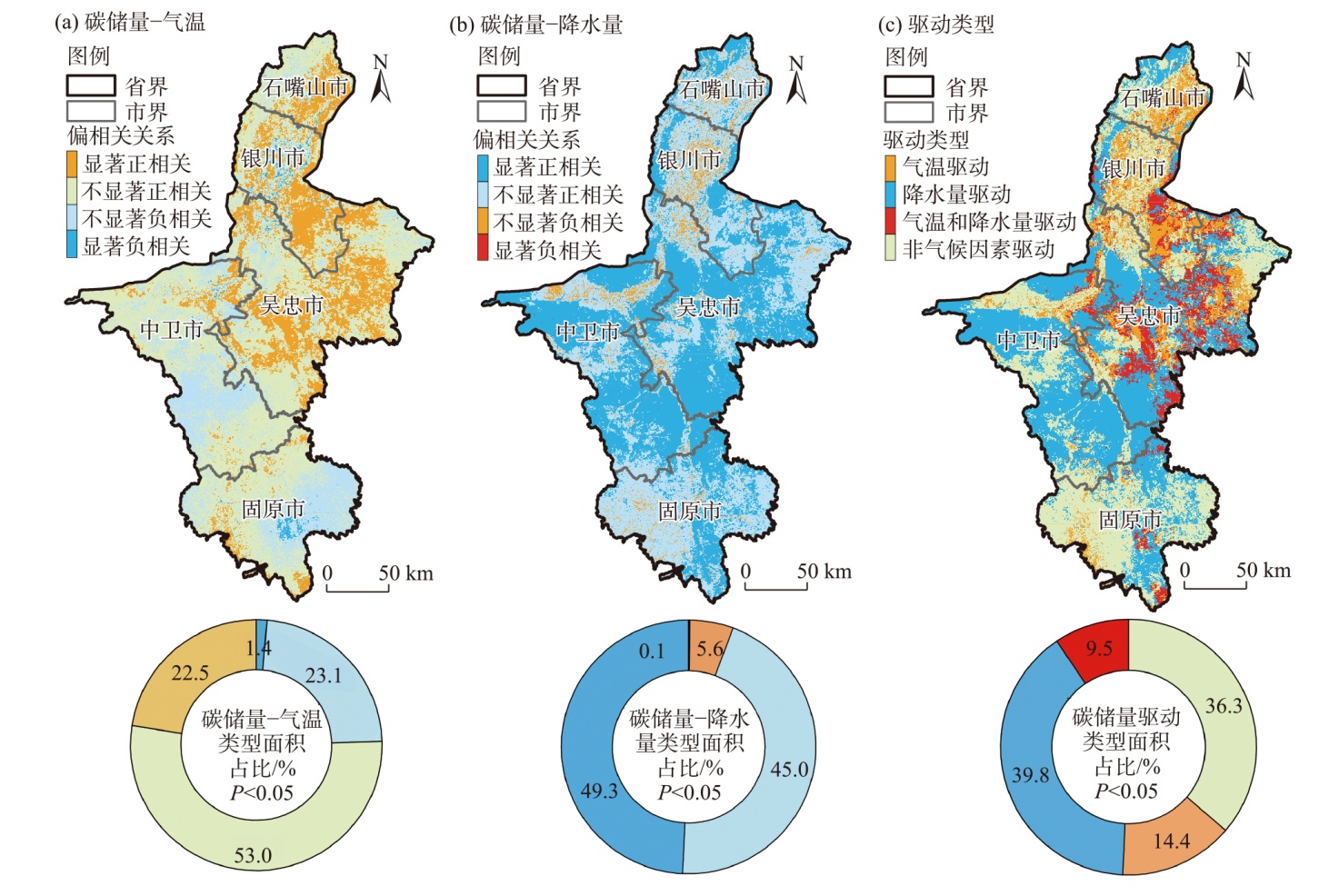
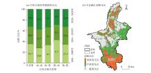
图9
宁夏碳储量空间自相关类型面积占比及诊断分区"

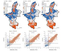
图10
宁夏碳储量空间自相关类型空间分布"

| [1] |
易丹, 欧名豪, 郭杰, 等. 土地利用碳排放及低碳优化研究进展与趋势展望[J]. 资源科学, 2022, 44(8): 1545-1559.
doi: 10.18402/resci.2022.08.02 |
|
[Yi Dan, Ou Minghao, Guo Jie, et al. Progress and prospect of research on land use carbon emissions and low-carbon optimization[J]. Resources Science, 2022, 44(8): 1545-1559.]
doi: 10.18402/resci.2022.08.02 |
|
| [2] | 刘坤, 张慧, 孔令辉, 等. 陆地生态系统碳汇评估方法研究进展[J]. 生态学报, 2023, 43(10): 4294-4307. |
| [Liu Kun, Zhang Hui, Kong Linghui, et al. An overview of terrestrial ecosystem carbon sink assessment methods towards achieving carbon neutrality in China[J]. Acta Ecologica Sinica, 2023, 43(10): 4294-4307.] | |
| [3] |
张一凡, 陈亚鹏, 陈亚宁, 等. 基于自然气候解决方案的新疆陆地生态系统固碳能力估算[J]. 干旱区地理, 2025, 48(7): 1198-1205.
doi: 10.12118/j.issn.1000-6060.2024.053 |
|
[Zhang Yifan, Chen Yapeng, Chen Yaning, et al. Estimation of carbon sequestration capacity of Xinjiang terrestrial ecosystem based on natural climate solutions[J]. Arid Land Geography, 2025, 48(7): 1198-1205.]
doi: 10.12118/j.issn.1000-6060.2024.053 |
|
| [4] | 梁森, 张建军, 王柯, 等. 区域生态保护修复碳汇潜力评估方法与应用——基于第一批山水林田湖草生态保护修复工程的研究[J]. 生态学报, 2023, 43(9): 3517-3531. |
| [Liang Sen, Zhang Jianjun, Wang Ke, et al. Methodology and application of carbon sink potential assessment for regional ecological conservation and restoration: Based on the research of the first batch of pilots for ecological protection and restoration project of mountains-rivers-forests-farmlands-lakes-grasslands system[J]. Acta Ecologica Sinica, 2023, 43(9): 3517-3531.] | |
| [5] |
黄贤金, 张秀英, 卢学鹤, 等. 面向碳中和的中国低碳国土开发利用[J]. 自然资源学报, 2021, 36(12): 2995-3006.
doi: 10.31497/zrzyxb.20211201 |
|
[Huang Xianjin, Zhang Xiuying, Lu Xuehe, et al. Land development and utilization for carbon neutralization[J]. Journal of Natural Resources, 2021, 36(12): 2995-3006.]
doi: 10.31497/zrzyxb.20211201 |
|
| [6] | Chen X, Yu L, Hou S, et al. Unraveling carbon stock dynamics and their determinants in China’s Loess Plateau over the past 40 years[J]. Ecological Indicators, 2024, 159: 111760, doi: 10.1016/j.ecolind.2024.111760. |
| [7] | Zhang J J, Yang J, Liu P F, et al. Effects of land use/cover change on terrestrial carbon stocks in the Yellow River Basin of China from 2000 to 2030[J]. Remote Sensing, 2024, 16: 1810, doi: 10.3390/rs16101810. |
| [8] | Ma Y Q, Li J H, Cao W, et al. Grain for green program to grassland might lead to carbon sink leakage in the Loess Plateau[J]. Earth’s Future, 2025, 13: e2024EF005261, doi: 10.1029/2024EF005261. |
| [9] | Yang Y, Liu L X, Zhang P P, et al. Large-scale ecosystem carbon stocks and their driving factors across Loess Plateau[J]. Carbon Neutrality, 2023, 2(1): 5, doi: 10.1007/s43979-023-00044-w. |
| [10] | 王少剑, 周诗洁, 方创琳, 等. 1980—2020年中国陆地生态系统碳储量时空格局与演进规律[J]. 中国科学: 地球科学, 2024, 54(10): 3323-3339. |
| [Wang Shaojian, Zhou Shijie, Fang Chuanglin, et al. Spatial-temporal patterns and evolution of carbon storage in China’s terrestrial ecosystems from 1980 to 2020[J]. Scientia Sinica (Terrae), 2024, 54(10): 3323-3339.] | |
| [11] |
谢立军, 白中科, 杨博宇, 等. 碳中和背景下国内外陆地生态系统碳汇评估方法研究进展[J]. 地学前缘, 2023, 30(2): 447-462.
doi: 10.13745/j.esf.sf.2022.2.78 |
|
[Xie Lijun, Bai Zhongke, Yang Boyu, et al. Carbon sequestration assessment methods at home and abroad for terrestrial ecosystems: Research progress in achieving carbon neutrality[J]. Earth Science Frontiers, 2023, 30(2): 447-462.]
doi: 10.13745/j.esf.sf.2022.2.78 |
|
| [12] | 朱建华, 田宇, 李奇, 等. 中国森林生态系统碳汇现状与潜力[J]. 生态学报, 2023, 43(9): 3442-3457. |
| [Zhu Jianhua, Tian Yu, Li Qi, et al. The current and potential carbon sink in forest ecosystem in China[J]. Acta Ecologica Sinica, 2023, 43(9): 3442-3457.] | |
| [13] |
戴尔阜, 黄宇, 吴卓, 等. 内蒙古草地生态系统碳源/汇时空格局及其与气候因子的关系[J]. 地理学报, 2016, 71(1): 21-34.
doi: 10.11821/dlxb201601002 |
|
[Dai Erfu, Huang Yu, Wu Zhuo, et al. Spatial-temporal features of carbon source-sink and its relationship with climate factors in Inner Mongolia grassland ecosystem[J]. Acta Geographica Sinica, 2016, 71(1): 21-34.]
doi: 10.11821/dlxb201601002 |
|
| [14] | 王菲, 曹永强, 周姝含, 等. 黄河流域生态功能区植被碳汇估算及其气候影响要素[J]. 生态学报, 2023, 43(6): 2501-2514. |
| [Wang Fei, Cao Yongqiang, Zhou Shuhan, et al. Estimation of vegetation carbon sink in the Yellow River Basin ecological function area and analysis of its main meteorological elements[J]. Acta Ecologica Sinica, 2023, 43(6): 2501-2514.] | |
| [15] | 毛永发, 周启刚, 王陶, 等. 耦合PLUS-InVEST-Geodector模型的三峡库区碳储量时空变化及其定量归因[J]. 长江流域资源与环境, 2023, 32(5): 1042-1057. |
| [Mao Yongfa, Zhou Qigang, Wang Tao, et al. Spatial-temporal variation of carbon storage and its quantitative attribution in the Three Gorges Reservoir Area coupled with PLUS-InVEST Geodector model[J]. Resources and Environment in the Yangtze Basin, 2023, 32(5): 1042-1057.] | |
| [16] |
邓元杰, 姚顺波, 侯孟阳, 等. 退耕还林还草工程对生态系统碳储存服务的影响——以黄土高原丘陵沟壑区子长县为例[J]. 自然资源学报, 2020, 35(4): 826-844.
doi: 10.31497/zrzyxb.20200407 |
|
[Deng Yuanjie, Yao Shunbo, Hou Mengyang, et al. Assessing the effects of the green for grain program on ecosystem carbon storage service by linking the InVEST and FLUS models: A case study of Zichang County in hilly and gully region of Loess Plateau[J]. Journal of Natural Resources, 2020, 35(4): 826-844.]
doi: 10.31497/zrzyxb.20200407 |
|
| [17] | Wu Q, Wang L, Wang T Y, et al. Spatial-temporal evolution analysis of multi-scenario land use and carbon storage based on PLUS-InVEST model: A case study in Dalian, China[J]. Ecological Indicators, 2024, 166: 112448, doi: 10.1016/j.ecolind.2024.112448. |
| [18] | 吴美玲, 邵彦川, 胡丽条, 等. 基于机器学习的中国陆地生态系统碳通量预测及其对土地利用变化的响应[J]. 环境科学, 2025, 46(8): 4733-4741. |
| [Wu Meiling, Shao Yanchuan, Hu Litiao, et al. Machine learning-based prediction of carbon fluxes in terrestrial ecosystems in China and its response to land use change[J]. Environmental Science, 2025, 46(8): 4733-4741.] | |
| [19] | 王可月, 王轶夫, 陈馨, 等. 基于集成学习算法和Optuna调优的江西省森林碳储量遥感估测[J]. 生态学报, 2025, 45(2): 685-700. |
| [Wang Keyue, Wang Yifu, Chen Xin, et al. Remote sensing estimation of forest carbon storage in Jiangxi Province based on ensemble learning algorithm and Optuna tuning[J]. Acta Ecologica Sinica, 2025, 45(2): 685-700.] | |
| [20] |
包玉斌, 王耀宗, 路锋, 等. 六盘山区国土空间生态安全格局构建与分区优化[J]. 干旱区研究, 2023, 40(7): 1172-1183.
doi: 10.13866/j.azr.2023.07.14 |
|
[Bao Yubin, Wang Yaozong, Lu Feng, et al. Construction of an ecological security pattern and zoning optimization for territorial space in the Liupan Mountain Area[J]. Arid Zone Research, 2023, 40(7): 1172-1183.]
doi: 10.13866/j.azr.2023.07.14 |
|
| [21] |
包玉斌, 黄涛, 王耀宗, 等. 基于生态重要性与敏感性的六盘山区生态保护修复分区[J]. 干旱区地理, 2023, 46(11): 1778-1791.
doi: 10.12118/j.issn.1000-6060.2023.053 |
|
[Bao Yubin, Huang Tao, Wang Yaozong, et al. Zoning for ecological conservation and restoration in Liupan Mountain area based on ecological importance and sensitivity evaluation[J]. Arid Land Geography, 2023, 46(11): 1778-1791.]
doi: 10.12118/j.issn.1000-6060.2023.053 |
|
| [22] | 赵慧, 李梦华, 杨建玲, 等. 2000—2020年宁夏植被净初级生产力时空变化及其驱动因子分析[J]. 气象与环境学报, 2024, 40(4): 107-115. |
| [Zhao Hui, Li Menghua, Yang Jianling, et al. Spatial and temporal variations of vegetation net primary productivity and its driving factors in Ningxia from 2000 to 2020[J]. Journal of Meteorology and Environment, 2024, 40(4): 107-115.] | |
| [23] | 全国森林资源标准化技术委员会(SAC/TC 370). GB/T43648-2024. 主要树种立木生物量模型与碳计量参数[S]. 北京: 中国标准出版社, 2024. |
| [National Technical Committee 370 on Forest Resources of Standardization Administration of China (SAC/TC 370). GB/T43648-2024. Tree biomass models and carbon accounting parameters for dominant species[S]. Beijing: Standards Press of China, 2024.] | |
| [24] | 林子琦, 温仲明, 刘洋洋, 等. 基于遥感数据的植被碳水利用效率时空变化和归因分析[J]. 生态学报, 2024, 44(1): 377-391. |
| [Lin Ziqi, Wen Zhongming, Liu Yangyang, et al. Spatiotemporal variation and attribution of carbon and water use efficiency in the Yellow River Basin based on remote sensing data[J]. Acta Ecologica Sinica, 2024, 44(1): 377-391.] | |
| [25] | 李彬, 曹广超, 王苑, 等. 2001—2022年黄河流域青海段植被NPP时空变化及其对气候的响应[J/OL]. 环境科学. [2025-08-02]. https://doi.org/10.13227/j.hjkx.202412233.. |
| [Li Bin, Cao Guangchao, Wang Yuan, et al. Spatial and temporal changes of vegetation NPP and its response to climate in the Qinghai section of the Yellow River Basin from 2001 to 2022[J/OL]. Environmental Science. [2025-08-02]. https://doi.org/10.13227/j.hjkx.202412233..] | |
| [26] | 徐勇, 黄雯婷, 郭振东, 等. 2000—2020年我国西南地区植被NEP时空变化及其驱动因素的相对贡献[J]. 环境科学研究, 2023, 36(3): 557-570. |
| [Xu Yong, Huang Wenting, Guo Zhendong, et al. Spatio-temporal variation of vegetation net ecosystem productivity and relative contribution of driving forces in southwest China from 2000 to 2020[J]. Research of Environmental Sciences, 2023, 36(3): 557-570.] | |
| [27] | 李美丽, 尹礼昌, 张园, 等. 基于MODIS-EVI的西南地区植被覆盖时空变化及驱动因素研究[J]. 生态学报, 2021, 41(3): 1138-1147. |
| [Li Meili, Yin Lichang, Zhang Yuan, et al. Spatio-temporal dynamics of fractional vegetation coverage based on MODIS-EVI and its driving factors in southwest China[J]. Acta Ecologica Sinica, 2021, 41(3): 1138-1147.] | |
| [28] | 曾庆雨, 孙才志. 黄河流域陆地生态系统碳储量测算及其影响因素[J]. 生态学报, 2024, 44(13): 5476-5493. |
| [Zeng Qingyu, Sun Caizhi. Estimation and influencing factors of carbon storage in terrestrial ecosystems in the Yellow River Basin[J]. Acta Ecologica Sinica, 2024, 44(13): 5476-5493.] | |
| [29] | 张怡, 王志慧, 卢小平, 等. 黄土高原生态系统碳汇时空变化及其影响因素[J]. 水土保持研究, 2025, 32(1): 266-274. |
| [Zhang Yi, Wang Zhihui, Lu Xiaoping, et al. Evolution of ecosystem carbon sink and its driving factors in the Loess Plateau[J]. Research of Soil and Water Conservation, 2025, 32(1): 266-274.] | |
| [30] | 吕文宝, 徐占军, 郭琦, 等. 黄土高原陆地生态系统碳储量的时间演进与空间分异特征[J]. 水土保持研究, 2024, 31(2): 252-263. |
| [Lü Wenbao, Xu Zhanjun, Guo Qi, et al. Research on the temporal evolution and spatial differentiation characteristics of carbon storage in terrestrial ecosystems on the Loess Plateau[J]. Research of Soil and Water Conservation, 2024, 31(2): 252-263.] | |
| [31] | Zhang Y, Cheng C X, Wang Z H, et al. Spatiotemporal variation and driving factors of carbon sequestration rate in terrestrial ecosystems of Ningxia, China[J]. Land, 2025, 14(1): 94, doi: 10.3390/land14010094. |
| [32] | 李妙宇, 上官周平, 邓蕾. 黄土高原地区生态系统碳储量空间分布及其影响因素[J]. 生态学报, 2021, 41(17): 6786-6799. |
| [Li Miaoyu, Shangguan Zhouping, Deng Lei. Spatial distribution of carbon storages in the terrestrial ecosystems and its influencing factors on the Loess Plateau[J]. Acta Ecologica Sinica, 2021, 41(17): 6786-6799.] |
| [1] | 陈文宣, 陈钰, 王生隆. 黄河流域农业碳排放时空演化特征及其影响因素分析[J]. 干旱区地理, 2026, 49(4): 713-726. |
| [2] | 芮东升, 毛璐, 任艳霞, 贡浩轩, 李延萍, 付志聪. 新疆相对贫困空间分布特征及障碍因素分析[J]. 干旱区地理, 2025, 48(9): 1672-1682. |
| [3] | 张毅明, 汤宇磊, 冯俊波. 基于随机森林模型的青藏高原冰川预测及分析[J]. 干旱区地理, 2025, 48(8): 1342-1352. |
| [4] | 张一凡, 陈亚鹏, 陈亚宁, 梁其祥. 基于自然气候解决方案的新疆陆地生态系统固碳能力估算[J]. 干旱区地理, 2025, 48(7): 1198-1205. |
| [5] | 苗颖凤, 原野, 周正伟, 赵嘉瑜, 郭宇茜. 汾渭平原农作物种植结构时空格局演变特征研究[J]. 干旱区地理, 2025, 48(6): 995-1005. |
| [6] | 张音, 孙从建, 刘庚, 钞锦龙, 耿甜伟, 刘宏红. 2000—2023年黄河流域山西段生态环境质量时空变化及其驱动因素[J]. 干旱区地理, 2025, 48(11): 1983-1994. |
| [7] | 马晓敏, 张志斌, 郭倩倩, 赵学伟, 张宁. 2000—2020年兰州市人口时空格局演变及驱动因素分析[J]. 干旱区地理, 2025, 48(1): 168-178. |
| [8] | 卢冬燕, 朱秀芳, 唐明秀, 郭春华, 刘婷婷. 不同温升情景下中国旱灾风险变化评估[J]. 干旱区地理, 2024, 47(3): 369-379. |
| [9] | 任贵秀, 刘凯. 黄河流域绿色创新的时空演化特征及影响因素分析[J]. 干旱区地理, 2024, 47(1): 158-169. |
| [10] | 袁宏伟, 蔡俊, 章磊. 国家重点生态功能区人类活动与生境质量时空变化特征及空间效应[J]. 干旱区地理, 2023, 46(6): 934-948. |
| [11] | 韩艳莉,于德永,陈克龙,杨海镇. 2000—2018年青海湖流域气温和降水量变化趋势空间分布特征[J]. 干旱区地理, 2022, 45(4): 999-1009. |
| [12] | 潘群,施海洋,张文强,罗格平,陈春波. 基于Cubist模型的天山北坡草地鼠群密度时空分布特征[J]. 干旱区地理, 2022, 45(4): 1200-1211. |
| [13] | 孙健武,高军波,马志飞,喻超,张欣怡. 不同地理环境下“空间贫困陷阱”分异机制比较——基于大别山与黄土高原的实证[J]. 干旱区地理, 2022, 45(2): 650-659. |
| [14] | 姜丽,魏天兴,李亦然,魏安琪. 地形因子对陕北黄土丘陵区防护林树种分布的影响[J]. 干旱区地理, 2021, 44(6): 1763-1771. |
| [15] | 黄越,程静,王鹏. 中国北方农牧交错区生态脆弱性时空演变格局与驱动因素——以盐池县为例[J]. 干旱区地理, 2021, 44(4): 1175-1185. |
|
||