干旱区地理 ›› 2026, Vol. 49 ›› Issue (3): 496-507.doi: 10.12118/j.issn.1000-6060.2025.257 cstr: 32274.14.ALG2025257
陈兵1,2( ), 王福涛1,2, 王世新1, 顾星光1,2, 朱金峰1()
收稿日期:2025-05-08
修回日期:2025-06-27
出版日期:2026-03-25
发布日期:2026-03-24
通讯作者:
朱金峰(1985-),男,博士,副研究员,主要从事灾害与环境遥感研究. E-mail: zhujf08@aircas.ac.cn作者简介:陈兵(2001-),女,硕士研究生,主要从事灾害与环境遥感研究. E-mail: chenb_cn@163.com
基金资助:
CHEN Bing1,2(), WANG Futao1,2, WANG Shixin1, GU Xingguang1,2, ZHU Jinfeng1()
Received:2025-05-08
Revised:2025-06-27
Published:2026-03-25
Online:2026-03-24
摘要:
冰湖不仅是宝贵的淡水资源和气候变化的重要指示器,同时也是许多自然灾害的孕育者。利用Landsat遥感影像,对中国与不丹跨境流域1990、2000、2010、2020年和2023年5个时期的冰湖轮廓进行目视解译,并结合气候、冰川及地形数据,探究该区域冰湖面积与数量变化的驱动因素。结果表明:(1)1990—2023年研究区冰湖总数量从1943个增至2413个,总面积从143.25 km2增至165.71 km2。其中,洛扎曲-库鲁河流域的冰湖面积增幅最大,增加6.24 km2;桑科希河流域的冰湖数量增幅最大,增加133个。(2)面积扩张显著的冰湖多集中在0.1~0.5 km2的规模范围,而新增冰湖则以面积小于0.02 km2的冰湖为主。冰湖变化最显著的海拔范围为5100~5200 m。(3)参数最优地理探测器分析表明,年平均气温与海拔是冰湖数量增长的驱动因素,而冰川体积与海拔是冰湖面积扩张的驱动因素。研究结果阐明了气候、冰川和地形共同影响冰湖演化的机制,为跨境流域冰湖溃决灾害风险评估提供了科学依据。
陈兵, 王福涛, 王世新, 顾星光, 朱金峰. 中国和不丹跨境流域冰湖变化特征及驱动因素[J]. 干旱区地理, 2026, 49(3): 496-507.
CHEN Bing, WANG Futao, WANG Shixin, GU Xingguang, ZHU Jinfeng. Characteristics and driving factors of glacial lake changes in transboundary basins between China and Bhutan[J]. Arid Land Geography, 2026, 49(3): 496-507.

图1
研究区示意图 注:编号① 康布麻曲-阿莫河流域;编号② 赖达克河流域;编号③ 桑科希河流域;编号④ 通萨河流域;编号⑤ 洛扎曲-库鲁河流域;编号⑥ 娘姆江曲-丹马河流域;编号⑦ 其他流域。下同。"
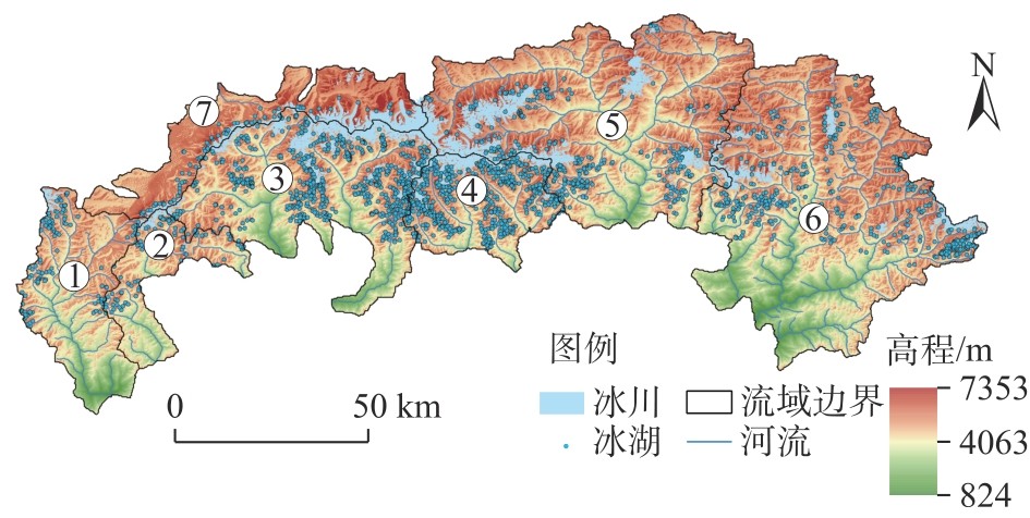
表1
1990—2023年中国-不丹跨境流域冰湖总数量与总面积"
| 年份 | 冰湖总数量/个 | 冰湖总面积/km2 |
|---|---|---|
| 1990 | 1943 | 143.25 |
| 2000 | 2215 | 153.66 |
| 2010 | 2243 | 157.78 |
| 2020 | 2367 | 164.42 |
| 2023 | 2413 | 165.71 |
表2
1990—2023年中国-不丹跨境流域冰湖总数量与总面积变化"
| 年份 | 冰湖总数量变化/个 | 冰湖总面积变化/km2 |
|---|---|---|
| 1990—2000 | 272 | 10.41 |
| 2000—2010 | 28 | 4.12 |
| 2010—2020 | 124 | 6.64 |
| 2020—2023 | 46 | 1.29 |
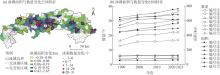
图2
1990—2023年中国-不丹跨境流域各流域冰湖数量与面积变化"

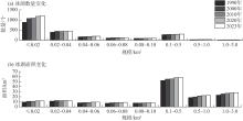
图3
1990—2023年中国和不丹跨境流域不同规模冰湖数量与面积变化"
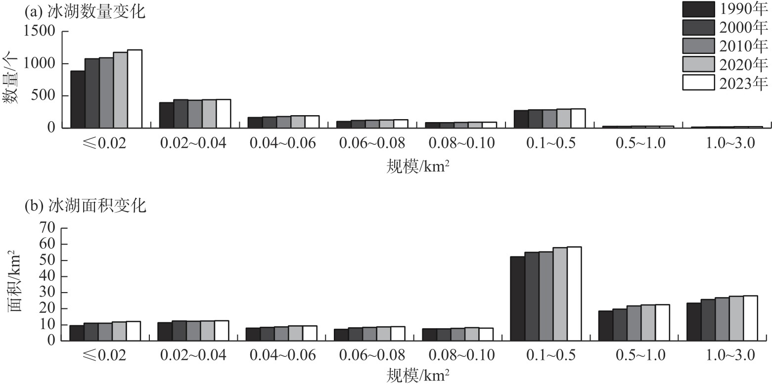
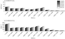
图4
1990—2023年中国和不丹跨境流域不同海拔冰湖数量与面积变化"
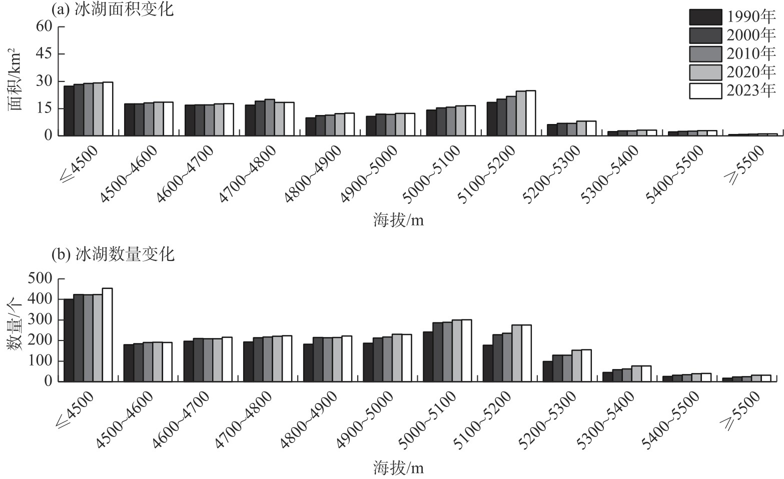
图5
1990—2023年中国-不丹跨境流域年平均气温和年降水量分布及变化趋势"
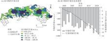
图6
1999—2021年中国-不丹跨境流域冰川物质平衡分布及变化"
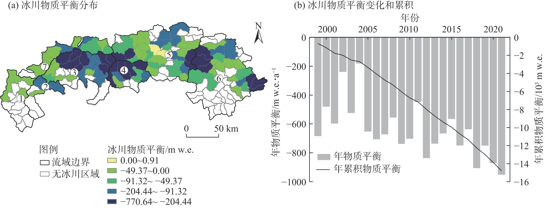

图7
1999—2021年中国-不丹跨境流域冰川融水径流和体积变化趋势"
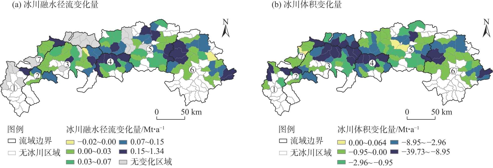
表3
影响中国-不丹跨境流域冰湖变化的驱动因素的因子探测"
| 因变量 | 驱动因素 | 解释力(q值) |
|---|---|---|
| 冰湖面积变化量 | 平均海拔 | 0.48 |
| 年平均气温变化量 | 0.51* | |
| 年降水变化量 | 0.39 | |
| 冰川物质平衡累积量 | 0.67** | |
| 冰川体积变化量 | 0.64** | |
| 冰川融水径流变化量 | 0.72** | |
| 冰湖数量变化量 | 平均海拔 | 0.63** |
| 年平均气温变化量 | 0.43 | |
| 年降水变化量 | 0.37 | |
| 冰川物质平衡累积量 | 0.74** | |
| 冰川体积变化量 | 0.74** | |
| 冰川融水径流变化量 | 0.75** |
图8
影响中国-不丹跨境流域冰湖变化的驱动因素交互探测"

| [1] |
陈满, 陈亚宁, 方功焕, 等. 昆仑山北坡冰川湖变化及其溃决风险评估[J]. 干旱区地理, 2024, 47(10): 1628-1639.
doi: 10.12118/j.issn.1000-6060.2024.178 |
|
[Chen Man, Chen Yaning, Fang Gonghuan, et al. Changes in glacial lakes on the northern slope of Kunlun Mountains and assessment of their outburst risks[J]. Arid Land Geography, 2024, 47(10): 1628-1639.]
doi: 10.12118/j.issn.1000-6060.2024.178 |
|
| [2] | 樊星, 秦圆圆, 高翔. IPCC第六次评估报告第一工作组报告主要结论解读及建议[J]. 环境保护, 2021, 49(增刊2): 44-48. |
| [Fan Xing, Qin Yuanyuan, Gao Xiang. Interpretation of the main conclusions and suggestions of IPCC AR6 Working Group I Report[J]. Environmental Protection, 2021, 49(Suppl. 2): 44-48.] | |
| [3] | Maurer J M, Schaefer J M, Rupper S, et al. Acceleration of ice loss across the Himalayas over the past 40 years[J]. Science Advances, 2019, 5(6): eaav7266, doi: 10.1126/sciadv.aav7266. |
| [4] |
The GlaMBIE Team, Zemp M, Jakob L, et al. Community estimate of global glacier mass changes from 2000 to 2023[J]. Nature, 2025, 639: 382-388.
doi: 10.1038/s41586-024-08545-z |
| [5] |
Zheng G X, Allen S K, Bao A, et al. Increasing risk of glacial lake outburst floods from future Third Pole deglaciation[J]. Nature Climate Change, 2021, 11(5): 411-417.
doi: 10.1038/s41558-021-01028-3 |
| [6] |
Zhang T G, Wang W C, An B S, et al. Enhanced glacial lake activity threatens numerous communities and infrastructure in the Third Pole[J]. Nature Communications, 2023, 14: 8250, doi: 10.1038/s41467-023-44123-z.
pmid: 38086866 |
| [7] | Gouli M R, Hu K, Khadka N, et al. Quantitative assessment of the GLOF risk along China-Nepal transboundary basins by integrating remote sensing, machine learning, and hydrodynamic model[J]. International Journal of Disaster Risk Reduction, 2025, 118: 105231, doi: 10.1016/j.ijdrr.2025.105231. |
| [8] | 宫鹏, 姚晓军, 孙美平, 等. 1967—2014年科西河流域冰湖时空变化[J]. 生态学报, 2017, 37(24): 8422-8432. |
| [Gong Peng, Yao Xiaojun, Sun Meiping, et al. Spatial-temporal variations of glacial lakes in the Koshi River Basin from 1967 to 2014[J]. Acta Ecologica Sinica, 2017, 37(24): 8422-8432.] | |
| [9] |
李志杰, 王宁练, 张玉杰, 等. 中塔帕米尔公路沿线地区冰川灾害暴露度评估[J]. 干旱区地理, 2025, 48(7): 1167-1175.
doi: 10.12118/j.issn.1000-6060.2024.479 |
|
[Li Zhijie, Wang Ninglian, Zhang Yujie, et al. Assessment of glacier disaster exposure in the areas along the China-Tajikistan Pamir Highway[J]. Arid Land Geography, 2025, 48(7): 1167-1175.
doi: 10.12118/j.issn.1000-6060.2024.479 |
|
| [10] |
张太刚, 王伟财, 高坛光, 等. 亚洲高山区冰湖溃决洪水事件回顾[J]. 冰川冻土, 2021, 43(6): 1673-1692.
doi: 10.7522/j.issn.1000-0240.2021.0066 |
|
[Zhang Taigang, Wang Weicai, Gao Tanguang, et al. Glacial lake outburst floods on the High Mountain Asia: A review[J]. Journal of Glaciology and Geocryology, 2021, 43(6): 1673-1692.]
doi: 10.7522/j.issn.1000-0240.2021.0066 |
|
| [11] |
Watanabe T, Rothacher D. The 1994 Lugge Tsho glacial lake outburst flood, Bhutan Himalaya[J]. Mountain Research and Development, 1996, 16: 77-81.
doi: 10.2307/3673897 |
| [12] | Gurung D R, Khanal N R, Bajracharya S R, et al. Lemthang Tsho glacial lake outburst flood (GLOF) in Bhutan: Cause and impact[J]. Geoenvironmental Disasters, 2017, 4: 17, doi: 10.1186/s40677-017-0080-2. |
| [13] | 王晶, 杨太保, 冀琴, 等. 1990—2015年喜马拉雅山东段中国和不丹边境地区冰川变化研究[J]. 干旱区地理, 2019, 42(3): 542-550. |
| [Wang Jing, Yang Taibao, Ji Qin, et al. Change of the modern glaciers in the eastern Himalaya near China and Bhutan border area from 1990 to 2015[J]. Arid Land Geography, 2019, 42(3): 542-550.] | |
| [14] | Rinzin S, Zhang G Q, Sattar A, et al. GLOF hazard, exposure, vulnerability, and risk assessment of potentially dangerous glacial lakes in the Bhutan Himalaya[J]. Journal of Hydrology, 2023, 619: 129311, doi: 10.1016/j.jhydrol.2023.129311. |
| [15] | 李治国, 姚檀栋, 叶庆华, 等. 1980—2007年喜马拉雅东段洛扎地区冰川和冰湖变化研究[J]. 干旱区资源与环境, 2012, 26(7): 47-52. |
| [Li Zhiguo, Yao Tandong, Ye Qinghua, et al. Variations of glaciers and glacial lakes in the Luozha region, eastern Himalayas, from 1980 to 2007[J]. Journal of Arid Land Resources and Environment, 2012, 26(7): 47-52.] | |
| [16] |
Zhao H Y, Su B, Lei H J, et al. A new projection for glacier mass and runoff changes over High Mountain Asia[J]. Science Bulletin, 2023, 68(1): 43-47.
doi: 10.1016/j.scib.2022.12.004 pmid: 36682858 |
| [17] |
Wang X, Guo X Y, Yang C D, et al. Glacial lake inventory of high-mountain Asia in 1990 and 2018 derived from Landsat images[J]. Earth System Science Data, 2020, 12(3): 2169-2182.
doi: 10.5194/essd-12-2169-2020 |
| [18] |
刘帅琪, 李均力, 李若楠, 等. 基于Sentinel-2影像的新疆冰湖制图及空间分布特征[J]. 冰川冻土, 2024, 46(2): 513-524.
doi: 10.7522/j.issn.1000-0240.2024.0042 |
|
[Liu Shuaiqi, Li Junli, Li Ruonan, et al. Mapping and spatial distribution characteristics of glacial lakes in Xinjiang based on Sentinel-2 imagery[J]. Journal of Glaciology and Geocryology, 2024, 46(2): 513-524.]
doi: 10.7522/j.issn.1000-0240.2024.0042 |
|
| [19] |
黄晓龙, 吴薇, 许剑辉, 等. ERA5-Land降水再分析资料在中国西南地区的适用性评估[J]. 高原气象, 2023, 42(6): 1562-1575.
doi: 10.7522/j.issn.1000-0534.2023.00012 |
|
[Huang Xiaolong, Wu Wei, Xu Jianhui, et al. The applicability performance of the ERA5-Land precipitation datasets in southwest China[J]. Plateau Meteorology, 2023, 42(6): 1562-1575.]
doi: 10.7522/j.issn.1000-0534.2023.00012 |
|
| [20] | Kumar M, Hodnebrog Ø, Daloz A S, et al. Measuring precipitation in eastern Himalaya: Ground validation of eleven satellite, model and gauge interpolated gridded products[J]. Journal of Hydrology, 2021, 599: 126252, doi: 10.1016/j.jhydrol.2021.126252. |
| [21] | 侯晓静, 段克勤, 石培宏, 等. 基于ERA5-Land数据的1961—2020年喜马拉雅山地区气温变化特征[J]. 山地学报, 2024, 42(3): 320-333. |
| [Hou Xiaojing, Duan Keqin, Shi Peihong, et al. Temperature change in the Himalayas from 1961 to 2020 based on ERA5-Land data[J]. Mountain Research, 2024, 42(3): 320-333.] | |
| [22] | 国家青藏高原科学数据中心. 亚洲高山区冰川物质平衡和融水径流模拟与预估数据集(2000—2100) v1.0[DB/OL]. [2025-06-04]. https://data.tpdc.ac.cn/zh-hans/data/a821db23-c1d9-4996-8f2b-71b61d915648. |
| [National Tibetan Plateau/Third Pole Environment Data Center. Glacier mass balance and meltwater runoff simulation and projection in High Mountain Asia (2000—2100) v1.0[DB/OL]. [2025-06-04].] | |
| [23] | 马劲松, 宋春桥, 王艳君, 等. 亚洲冰川湖泊分类与最大分布数据集(1980s—2019)[J]. 全球变化数据学报(中英文), 2022, 6(2): 200-208, 372-380. |
| [Ma Jinsong, Song Chunqiao, Wang Yanjun, et al. Dataset of maximum extent and type of glacial lake in the Asia (1980s—2019)[J]. Journal of Global Change Data & Discovery, 2022, 6(2): 200-208, 372-380.] | |
| [24] | 闫斌, 贾洪果, 任文静, 等. 基于NDWI-NDSI组合阈值法的布加岗日冰湖提取及其变化分析[J]. 遥感学报, 2022, 26(11): 2344-2353. |
|
[Yan Bin, Jia Hongguo, Ren Wenjing, et al. Glacier lake extraction and variation analysis of the Bujiagangri glacier based on the NDWI-NDSI combination threshold method[J]. National Remote Sensing Bulletin, 2022, 26(11): 2344-2353.]
doi: 10.11834/jrs.20210205 |
|
| [25] |
李梦帆, 郑江华, 钱安良, 等. 基于决策树的天山冰湖提取方法研究[J]. 干旱区研究, 2024, 41(10): 1699-1707.
doi: 10.13866/j.azr.2024.10.08 |
|
[Li Mengfan, Zheng Jianghua, Qian Anliang, et al. Research on the extraction method of Tianshan glacier lake based on decision tree[J]. Arid Zone Research, 2024, 41(10): 1699-1707.]
doi: 10.13866/j.azr.2024.10.08 |
|
| [26] |
尹力辰, 王欣, 殷永胜, 等. 基于深度学习和Sentinel-2影像的冰湖自动提取[J]. 遥感技术与应用, 2024, 39(6): 1319-1329.
doi: 10.11873/j.issn.1004-0323.2024.6.1319 |
| [Yin Lichen, Wang Xin, Yin Yongsheng, et al. Automatic extraction of glacial lakes based on deep learning and Sentinel-2 imagery[J]. Remote Sensing Technology and Application, 2024, 39(6): 1319-1329.] | |
| [27] | 殷永胜, 王欣, 刘时银, 等. 1990—2020年中国冰湖变化特征及影响因素[J]. 湖泊科学, 2023, 35(1): 358-367. |
| [Yin Yongsheng, Wang Xin, Liu Shiyin, et al. Characteristics and influence factors of the glacial lake changes in China from 1990 to 2020[J]. Journal of Lake Sciences, 2023, 35(1): 358-367.] | |
| [28] | Luo W, Zhang G Q, Chen W F, et al. Response of glacial lakes to glacier and climate changes in the western Nyainqentanglha range[J]. Science of the Total Environment, 2020, 735: 139607, doi: 10.1016/j.scitotenv.2020.139607. |
| [29] |
Sen P K. Estimates of the regression coefficient based on Kendall’s Tau[J]. Journal of the American Statistical Association, 1968, 63(324): 1379-1389.
doi: 10.1080/01621459.1968.10480934 |
| [30] |
Mann H B. Nonparametric tests against trend[J]. Econometrica, 1945, 13(3): 245-259.
doi: 10.2307/1907187 |
| [31] | 孙美平, 李忠勤, 姚晓军, 等. 1959—2008年乌鲁木齐河源1号冰川融水径流变化及其原因[J]. 自然资源学报, 2012, 27(4): 650-660. |
| [Sun Meiping, Li Zhongqin, Yao Xiaojun, et al. Analysis on runoff variation of glacier No. 1 at the headwaters of the Urumqi River from 1959 to 2008[J]. Journal of Natural Resources, 2012, 27(4): 650-660.] | |
| [32] |
王南, 刘泽轩, 郑江华, 等. 天山冰湖分布时空特征及驱动力分析[J]. 干旱区地理, 2024, 47(9): 1472-1481.
doi: 10.12118/j.issn.1000-6060.2023.673 |
|
[Wang Nan, Liu Zexuan, Zheng Jianghua, et al. Spatiotemporal characteristics and driving forces of glacial lakes in Tianshan Mountains[J]. Arid Land Geography, 2024, 47(9): 1472-1481.]
doi: 10.12118/j.issn.1000-6060.2023.673 |
|
| [33] |
王劲峰, 徐成东. 地理探测器: 原理与展望[J]. 地理学报, 2017, 72(1): 116-134.
doi: 10.11821/dlxb201701010 |
|
[Wang Jinfeng, Xu Chengdong. Geodetector: Principle and prospective[J]. Acta Geographica Sinica, 2017, 72(1): 116-134.]
doi: 10.11821/dlxb201701010 |
|
| [34] |
汪宙峰, 郑博, 贺相綦, 等. 基于参数最优地理探测器的西藏冰湖时空变化与影响因素研究[J]. 冰川冻土, 2023, 45(6): 1950-1960.
doi: 10.7522/j.issn.1000-0240.2023.0149 |
|
[Wang Zhoufeng, Zheng Bo, He Xiangqi, et al. Spatial-temporal variations and influencing factors of glacial lakes in Xizang based on optimal parameters-based geographical detector[J]. Journal of Glaciology and Geocryology, 2023, 45(6): 1950-1960.]
doi: 10.7522/j.issn.1000-0240.2023.0149 |
|
| [35] | Song Y Z, Wang J F, Ge Y, et al. An optimal parameters-based geographical detector model enhances geographic characteristics of explanatory variables for spatial heterogeneity analysis: Cases with different types of spatial data[J]. GIScience & Remote Sensing, 2020, 57(5): 593-610. |
| [36] | 王欣, 吴坤鹏, 蒋亮虹, 等. 近20年天山地区冰湖变化特征[J]. 地理学报, 2013, 68(7): 983-993. |
| [Wang Xin, Wu Kunpeng, Jiang Lianghong, et al. Wide expansion of glacial lakes in Tianshan Mountains during 1990—2010[J]. Acta Geographica Sinica, 2013, 68(7): 983-993.] | |
| [37] | 孟乘枫, 仲涛, 郑江华. 2000—2020年新疆冰湖分布时空特征分析及影响因素分析[J]. 水文, 2024, 44(3): 52-59. |
| [Meng Chengfeng, Zhong Tao, Zheng Jianghua. Spatio-temporal characteristics and influencing factors of glacial lake distribution in Xinjiang from 2000 to 2020[J]. Journal of China Hydrology, 2024, 44(3): 52-59.] | |
| [38] | Tang Q, Zhang G Q, Yao T D, et al. Automatic extraction of glacial lakes from Landsat imagery using deep learning across the Third Pole region[J]. Remote Sensing of Environment, 2024, 315: 114413, doi: 10.1016/j.rse.2024.114413. |
| [39] |
Veh G, Wang B G, Zirzow A, et al. Progressively smaller glacier lake outburst floods despite worldwide growth in lake area[J]. Nature Water, 2025, 3: 271-283.
doi: 10.1038/s44221-025-00388-w |
| [40] | Wang X, Ran W J, Wei J F, et al. Spatially resolved glacial meltwater retainment in glacial lakes exerts increasing impacts in High Mountain Asia[J]. Journal of Hydrology, 2024, 633: 130967, doi: 10.1016/j.jhydrol.2024.130967. |
| [41] |
Nie Y, Sheng Y W, Liu Q, et al. A regional-scale assessment of Himalayan glacial lake changes using satellite observations from 1990 to 2015[J]. Remote Sensing of Environment, 2017, 189: 1-13.
doi: 10.1016/j.rse.2016.11.008 |
| [42] | Rinzin S, Zhang G Q, Wangchuk S. Glacial lake area change and potential outburst flood hazard assessment in the Bhutan Himalaya[J]. Frontiers in Earth Science, 2021, 9: 775195, doi: 10.3389/feart.2021.775195. |
| [43] |
Zhang G Q, Bolch T, Yao T D, et al. Underestimated mass loss from lake-terminating glaciers in the greater Himalaya[J]. Nature Geoscience, 2023, 16: 333-338.
doi: 10.1038/s41561-023-01150-1 |
| [1] | 王生霞, 武芯如. 中国西北地区数字经济与旅游经济韧性的协同演化[J]. 干旱区地理, 2026, 49(3): 462-473. |
| [2] | 张博, 徐红罡. 气候变化对山地冰川旅游的影响与风险综述[J]. 干旱区地理, 2026, 49(3): 474-483. |
| [3] | 周灵敏, 伊木然·库鲁万, 玉素甫江·如素力, 吴海智, 娜扎开提·尼加提. 中国西北干旱区大型湖泊湖冰物候时空差异及影响因素[J]. 干旱区地理, 2026, 49(3): 484-495. |
| [4] | 白洋, 陈明珠, 周春山, 李亚茹, 唐诚. 中国旅游新质生产力的演化测度与障碍识别[J]. 干旱区地理, 2026, 49(2): 211-223. |
| [5] | 曹晓云, 周秉荣, 雷春苗, 刘致远, 史飞飞, 颜玉倩. 基于遥感监测的1980—2020年三江源雪深时空变化与气候归因研究[J]. 干旱区地理, 2026, 49(2): 356-368. |
| [6] | 程西安, 牛全福, 王刚, 邵东虎, 朱登峰, 王振宇. 黄土高原植被抗旱性监测及影响因素分析[J]. 干旱区地理, 2026, 49(1): 1-12. |
| [7] | 李玲燕, 王萌萌, 夏浩鸣, 段蜜蜜. 中国西北生态脆弱区农户清洁能源使用的脆弱性及影响因素[J]. 干旱区地理, 2026, 49(1): 164-175. |
| [8] | 白洋, 唐诚, 陈明珠, 彭利, 赵平. 中国“生态-旅游-文化”系统协调发展与影响路径[J]. 干旱区地理, 2026, 49(1): 94-105. |
| [9] | 郑孟林, 赵勇, 杨霞. 中国西北干旱区夏季降水异常的主模态年代际变化及其联系环流[J]. 干旱区地理, 2025, 48(9): 1511-1520. |
| [10] | 张飞, 李建, 李慧融, 谢涛, 张雪红, 王超, 白淑英, 宋正姗. 2001—2024年锡林郭勒盟草原净初级生产力时空特征及对影响因子的响应[J]. 干旱区地理, 2025, 48(9): 1555-1566. |
| [11] | 李文华, 李生宇, 徐新文, 苗佳敏, 吕振涛. 基于MaxEnt模型预测气候变化下准噶尔沙蒿(Artemisia songarica)在新疆的潜在分布[J]. 干旱区地理, 2025, 48(9): 1578-1588. |
| [12] | 张春燕, 李岩瑛, 吴雯, 陈静, 马幸蔚, 聂鑫. 河西走廊夏秋季2次强沙尘暴天气成因及传输特征分析[J]. 干旱区地理, 2025, 48(8): 1363-1373. |
| [13] | 罗小梅, 文琦, 施琳娜, 吴昕燕, 安丰平, 王振亭. 多维视角下中国北方农牧交错带县域收缩识别及影响因素分析[J]. 干旱区地理, 2025, 48(7): 1267-1278. |
| [14] | 陈世泷, 孟庆凯, 戴勇, 杨立强, 吴晗. 基于CMIP6未来情景的伊犁河流域地质灾害危险性评估预测[J]. 干旱区地理, 2025, 48(4): 599-611. |
| [15] | 王希, 李微, 朱涛, 金文哲, 孙建富. 基于文献计量的艾比湖区域遥感研究进展与热点分析[J]. 干旱区地理, 2025, 48(4): 689-703. |
|
||