- 2025年8月18日 星期一
干旱区地理 ›› 2025, Vol. 48 ›› Issue (4): 689-703.doi: 10.12118/j.issn.1000-6060.2024.378 cstr: 32274.14.ALG2024378
王希1( ), 李微1(), 朱涛1, 金文哲1, 孙建富2
收稿日期:2024-06-17
修回日期:2024-10-21
出版日期:2025-04-25
发布日期:2025-04-18
通讯作者:
李微(1980-),女,教授,主要从事海洋遥感、湖泊遥感、滨海湿地典型植被遥感监测等研究. E-mail: liwei2009@dlou.edu.cn作者简介:王希(1999-),女,硕士研究生,主要从事海洋遥感等研究. E-mail: m18834821924@163.com
基金资助:
WANG Xi1(), LI Wei1(), ZHU Tao1, JIN Wenzhe1, SUN Jianfu2
Received:2024-06-17
Revised:2024-10-21
Published:2025-04-25
Online:2025-04-18
摘要:
艾比湖作为典型的干旱区湖泊,其保护与研究对于应对生态退化以及维护生态平衡具有重要意义。遥感技术以其能够提供大范围、多尺度和多时相连续观测数据的特点,在监测干旱区湖泊的生态环境变化方面显示出巨大的优势。运用CiteSpace软件对1990—2023年中国知网(CNKI)和Web of Science(WOS)数据库中有关艾比湖区域遥感技术研究的340篇文章进行文献可视化分析,综合分析了该领域文献的发文量、研究力量和研究热点,揭示了相关研究的演进历程、研究焦点及其演变趋势。结果表明:该领域的研究始于1990年,经历了萌芽期、快速增长期以及近年来的发展减缓期;核心作者群体和研究机构已经形成,但在跨学科合作方面还存在提升空间;研究热点包括艾比湖、艾比湖湿地和艾比湖流域的相关主题,从早期的湖面变化和荒漠化监测分析,逐步转向生态系统服务价值、土地利用及景观格局变化等多元化方向。为理解艾比湖区域遥感技术研究的发展态势提供了科学依据,并对未来的研究方向提出了建议。
王希, 李微, 朱涛, 金文哲, 孙建富. 基于文献计量的艾比湖区域遥感研究进展与热点分析[J]. 干旱区地理, 2025, 48(4): 689-703.
WANG Xi, LI Wei, ZHU Tao, JIN Wenzhe, SUN Jianfu. Progress and hotspot analysis of remote sensing research in the Ebinur Lake area based on bibliometrics[J]. Arid Land Geography, 2025, 48(4): 689-703.

图1
1990—2023年艾比湖区域遥感技术研究文献数量"
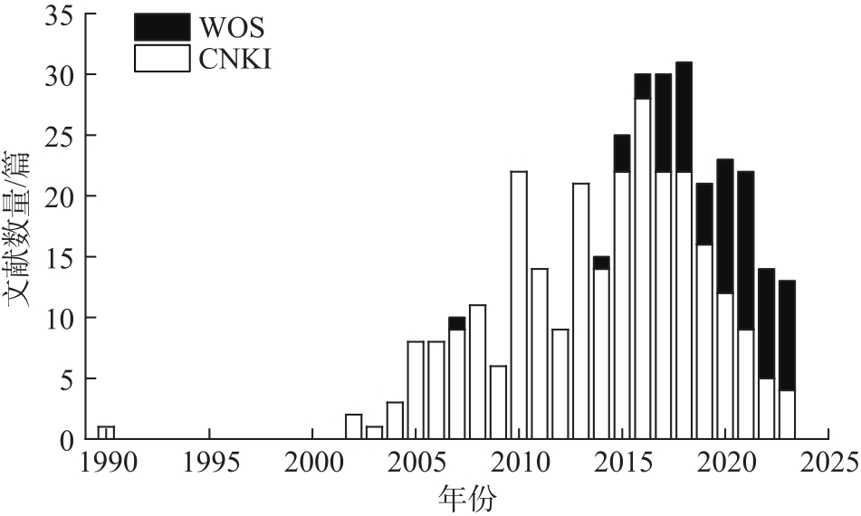
表1
艾比湖区域遥感技术研究发文量TOP10中文来源"
| 来源 | 发文量 | 影响因子 | 类型 |
|---|---|---|---|
| 新疆大学 | 44 | - | 硕、博士毕业论文 |
| 新疆师范大学 | 22 | - | 硕、博士毕业论文 |
| 农业工程学报 | 11 | 2.788 | 期刊 |
| 干旱区地理 | 11 | 2.687 | 期刊 |
| 中国沙漠 | 9 | 2.251 | 期刊 |
| 光谱学与光谱分析 | 8 | 1.159 | 期刊 |
| 水土保持通报 | 7 | 1.732 | 期刊 |
| 生态学报 | 7 | 4.065 | 期刊 |
| 干旱区资源与环境 | 6 | 2.615 | 期刊 |
| 湖泊科学 | 5 | 3.360 | 期刊 |
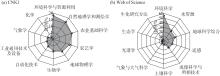
图2
艾比湖区域遥感技术研究TOP10学科"
表2
艾比湖区域遥感技术研究发文量TOP10作者"
| 作者 | 机构 | 发文量 | 中心性 |
|---|---|---|---|
| 张飞 | 新疆大学 | 71 | 0.16 |
| 丁建丽 | 新疆大学 | 52 | 0.15 |
| 王敬哲 | 新疆大学 | 26 | 0.06 |
| Kung Hsiang-te | 美国孟菲斯大学 | 24 | 0.04 |
| 葛翔宇 | 新疆大学 | 17 | 0.01 |
| 王娟 | 新疆大学 | 16 | 0.02 |
| 王小平 | 新疆大学 | 16 | 0.00 |
| 张月 | 美国科罗拉多梅萨大学 | 13 | 0.09 |
| Johnson Verner C | 新疆大学 | 12 | 0.02 |
| 李哲 | 新疆大学 | 12 | 0.03 |
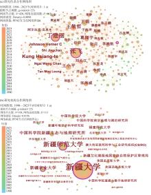
图3
艾比湖区域遥感技术研究作者及机构合作网络图"

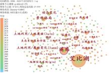
图4
艾比湖区域遥感技术研究关键词网络图谱"
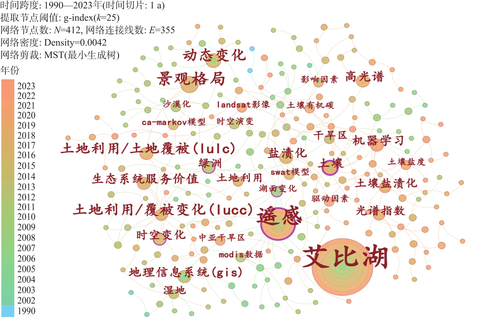
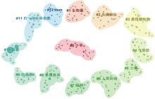
图5
艾比湖区域遥感技术研究关键词聚类图谱 注:圆圈代表关键词,其大小代表出现的频率,圆圈越大表示频率越高。"
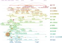
图6
艾比湖区域遥感技术研究关键词时间线图谱"

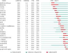
图7
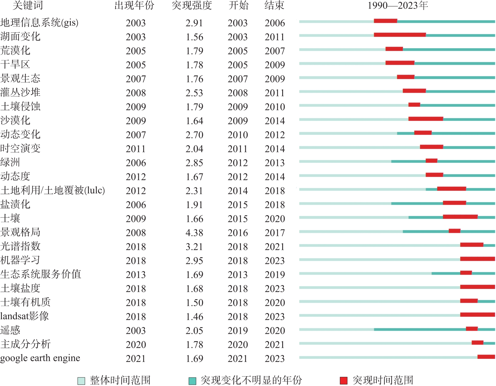
艾比湖区域遥感技术研究前25位突现词图谱"
| [1] | 王欣, 刘建强, 丁静, 等. HY-1C卫星CZI影像卤虫条带提取研究——以艾比湖为例[J]. 遥感学报, 2023, 27(1): 104-115. |
| [Wang Xin, Liu Jianqiang, Ding Jing, et al. Extraction of Artemia slicks from HY-1C CZI images: Taking Ebinur Lake as an example[J]. National Remote Sensing Bulletin, 2023, 27(1): 104-115.] | |
| [2] |
希丽娜依·多来提, 阿里木江·卡斯木, 如克亚·热合曼, 等. 基于四种水体指数的艾比湖水面提取及时空变化分析[J]. 长江科学院院报, 2022, 39(10): 134-140.
doi: 10.11988/ckyyb.20210634 |
| [Duolaiti Xilinayi, Kasim Alim, Reheman Rukeya, et al. Water body extraction of Ebinur Lake based on four water indexes and analysis of spatial-temporal changes[J]. Journal of the Yangtze River Scientific Research Institute, 2022, 39(10): 134-140.] | |
| [3] | 段洪涛, 曹志刚, 沈明, 等. 湖泊遥感研究进展与展望[J]. 遥感学报, 2022, 26(1): 3-18. |
| [Duan Hongtao, Cao Zhigang, Shen Ming, et al. Review of lake remote sensing research[J]. National Remote Sensing Bulletin, 2022, 26(1): 3-18.] | |
| [4] | 蔡剑英, 王烜, 李春晖, 等. 湿地景观格局研究前沿热点及发展趋势[J]. 西南大学学报(自然科学版), 2022, 44(10): 127-139. |
| [Cai Jianying, Wang Xuan, Li Chunhui, et al. Frontier hotspots and development trend of wetland landscape pattern research[J]. Journal of Southwest University (Natural Science Edition), 2022, 44(10): 127-139.] | |
| [5] | 曲孝云, 侯东杰, 陆帅志, 等. 基于文献计量分析的青藏高原草地研究[J]. 生态学报, 2023, 43(19): 8229-8240. |
| [Qu Xiaoyun, Hou Dongjie, Lu Shuaizhi, et al. Grassland research on the Tibetan Plateau based on bibliometric analysis[J]. Acta Ecologica Sinica, 2023, 43(19): 8229-8240.] | |
| [6] | Chen C M. CiteSpace II: Detecting and visualizing emerging trends[J]. Journal of the American Society for Information Science & Technology, 2006, 57(3): 359-377. |
| [7] | 胡泽文, 孙建军, 武夷山. 国内知识图谱应用研究综述[J]. 图书情报工作, 2013, 57(3): 131-137, 84. |
| [Hu Zewen, Sun Jianjun, Wu Yishan. Research review on application of knowledge mapping in China[J]. Library and Information Service, 2013, 57(3): 131-137, 84.] | |
| [8] |
陈强强, 杨凌. 近30 a黄河流域人地系统研究: 脉络、热点及展望[J]. 干旱区地理, 2023, 46(10): 1692-1703.
doi: 10.12118/j.issn.1000-6060.2023.036 |
|
[Chen Qiangqiang, Yang Ling. Studies of the human-land system in the Yellow River Basin for 30 years: Context, hotspots and prospects[J]. Arid Land Geography, 2023, 46(10): 1692-1703.]
doi: 10.12118/j.issn.1000-6060.2023.036 |
|
| [9] | 袁国映. 艾比湖退缩及其对环境的影响[J]. 干旱区地理, 1990, 13(4): 62-67. |
| [Yuan Guoying. A declining Aibi Lake and its effect on environment[J]. Arid Land Geography, 1990, 13(4): 62-67.] | |
| [10] | 李玲. 基于馆际互借与文献传递的文献信息资源共享服务知识图谱研究[J]. 现代情报, 2015, 35(5): 98-104. |
| [Li Ling. Mapping knowledge analysis of information resources sharing service on the interlibrary loan and document delivery[J]. Journal of Modern Information, 2015, 35(5): 98-104.] | |
| [11] | Duan P, Zhang F, Liu C J, et al. High-resolution planetscope imagery and machine learning for estimating suspended particulate matter in the Ebinur Lake, Xinjiang, China[J]. IEEE Journal of Selected Topics in Applied Earth Observations and Remote Sensing, 2023, 16: 1019-1032. |
| [12] |
丁建丽, 葛翔宇, 王敬哲. 中国艾比湖湿地识别及其时空动态变化[J]. 自然资源学报, 2021, 36(8): 1949-1963.
doi: 10.31497/zrzyxb.20210804 |
|
[Ding Jianli, Ge Xiangyu, Wang Jingzhe. Ebinur Lake wetland identification and its spatio-temporal dynamic changes[J]. Journal of Natural Resources, 2021, 36(8): 1949-1963.]
doi: 10.31497/zrzyxb.20210804 |
|
| [13] | 李微, 刘伟男, 贾越平, 等. 基于面向对象法艾比湖卤虫信息提取[J]. 国土资源遥感, 2018, 30(4): 176-181. |
| [Li Wei, Liu Weinan, Jia Yueping, et al. Information extraction of the Ebinur Lake Artemia based on object-oriented method[J]. Remote Sensing for Land and Resources, 2018, 30(4): 176-181.] | |
| [14] | Tian L, Tian J Y, Wang J R, et al. A novel remote sensing index for brine shrimp (Artemia) slick detection in salt lakes[J]. Remote Sensing of Environment, 2023, 286: 113428, doi: 10.1016/j.rse.2022.113428. |
| [15] |
钟洋, 孔令宇, 董秀军. 基于CiteSpace和VOSviewer的区域协调发展的研究进展与展望[J]. 干旱区地理, 2024, 47(12): 2135-2151.
doi: 10.12118/j.issn.1000-6060.2024.084 |
| [Zhong Yang, Kong Lingyu, Dong Xiujun. Research progress and prospects of regional coordinated development based on CiteSpace and VOSviewer[J]. Arid Land Geography, 2024, 47(12): 2135-2151.] | |
| [16] | Xie B, Ding J, Ge X Y, et al. Estimation of soil organic carbon content in the Ebinur Lake wetland, Xinjiang, China, based on multisource remote sensing data and ensemble learning algorithms[J]. Sensors, 2022, 22(7): 2685, doi: 10.3390/s22072685. |
| [17] | 雷彩云, 塔西甫拉提·特依拜. 基于遥感和GIS的新疆艾比湖区域土壤侵蚀强度评价[J]. 新疆农业科学, 2010, 27(2): 242-247. |
| [Lei Caiyun, Tiyip Tashpolat. Assessment on soil erosion in Xinjiang Ebinur Lake region using remote sense and GIS techniques[J]. Xinjiang Agricultural Science, 2010, 27(2): 242-247.] | |
| [18] | Ge X Y, Ding J L, Teng D X, et al. Exploring the capability of Gaofen-5 hyperspectral data for assessing soil salinity risks[J]. International Journal of Applied Earth Observation and Geoinformation, 2022, 112(3): 1-14. |
| [19] | 王瑾杰, 丁建丽, 张喆. 2008—2014年新疆艾比湖流域土壤水分时空分布特征[J]. 生态学报, 2019, 39(5): 1784-1794. |
| [Wang Jinjie, Ding Jianli, Zhang Zhe. Temporal-spatial dynamic change characteristics of soil moisture in Ebinur Lake Basin from 2008—2014[J]. Acta Ecologica Sinica, 2019, 39(5): 1784-1794.] | |
| [20] |
张桉赫, 丁建丽, 张钧泳, 等. 艾比湖绿洲实际蒸散量变化特征及与景观格局的关系[J]. 冰川冻土, 2021, 43(6): 1829-1839.
doi: 10.7522/j.issn.1000-0240.2018.1189 |
|
[Zhang Anhe, Ding Jianli, Zhang Junyong, et al. Variation characteristics of actual evapotranspiration in the Ebinur Lake oasis and its relationship with landscape pattern[J]. Journal of Glaciology and Geocryology, 2021, 43(6): 1829-1839.]
doi: 10.7522/j.issn.1000-0240.2018.1189 |
|
| [21] | 古丽克孜·阿不地腊合曼, 郑江华, 帕力孜旦·吾不力, 等. 基于遥感的绿洲动态变化研究——以艾比湖绿洲为例[J]. 安徽农业科学, 2013, 41(3): 1393-1396. |
| [Abdirahman Gulkiz, Zheng Jianghua, Wubuli Palizidan, et al. Study on dynamics of oasis based on remote sensing[J]. Journal of Anhui Agricultural Sciences, 2013, 41(3): 1393-1396.] | |
| [22] | 王宏, 唐娟, 陈文平, 等. 干旱区绿洲土地利用/土地覆被动态演变研究[J]. 测绘与空间地理信息, 2012, 35(11): 43-47. |
| [Wang Hong, Tang Juan, Chen Wenping, et al. Research on the land use/land cover dynamic evolution in the oasis of arid region[J]. Geomatics & Spatial Information Technology, 2012, 35(11): 43-47.] | |
| [23] | 李旭冰. 西天山北麓湖泊时空动态变化及影响因素研究[D]. 南京: 南京信息工程大学, 2022. |
| [Li Xubing. Study on the spatio-temporal dynamic changes of lakes in the northern foothills of the western Tianshan Mountains and their influencing factors[D]. Nanjing: Nanjing University of Information Science & Technology, 2022.] | |
| [24] | 朱刚, 高会军, 曾光. 近35 a来新疆干旱区湖泊变化及原因分析[J]. 干旱区地理, 2015, 38(1): 103-110. |
| [Zhu Gang, Gao Huijun, Zeng Guang. Lake change research and reasons analysis in Xinjiang arid regions during the past 35 years[J]. Arid Land Geography, 2015, 38(1): 103-110.] | |
| [25] | Zhou X H, Zhang F, Liu C J, et al. Soil salinity inversion based on novel spectral index[J]. Environmental Earth Sciences, 2021, 80(16): 1-13. |
| [26] | 白婷, 丁建丽, 王敬哲. 基于机器学习算法的土壤有机质质量比估算[J]. 排灌机械工程学报, 2020, 38(8): 829-834. |
| [Bai Ting, Ding Jianli, Wang Jingzhe. Estimation of soil organic matter content based on machine learning[J]. Journal of Drainage and Irrigation Machinery Engineering, 2020, 38(8): 829-834.] | |
| [27] | Li X, Ding J, Ilyas N. Machine learning method for quick identification of water quality index (WQI) based on Sentinel-2 MSI data: Ebinur Lake case study[J]. Water Science & Technology Water Supply, 2020, 21(3): 1291-1312. |
| [28] | 陈悦, 陈超美, 刘则渊, 等. CiteSpace知识图谱的方法论功能[J]. 科学学研究, 2015, 33(2): 242-253. |
| [Chen Yue, Chen Chaomei, Liu Zeyuan, et al. The methodology function of CiteSpace mapping knowledge domains[J]. Studies in Science of Science, 2015, 33(2): 242-253.] | |
| [29] | 杨和静, 吴荣. 基于CiteSpace和VOSviewer的近20年国内城市湿地公园景观研究知识图谱分析[J]. 现代园艺, 2023, 46(6): 180-183. |
| [Yang Hejing, Wu Rong. Analysis of the knowledge map of domestic urban wetland park landscape research in the past 20 years based on CiteSpace and VOSviewer[J]. Contemporary Horticulture, 2023, 46(6): 180-183.] | |
| [30] | 宫恒瑞. 基于遥感技术的艾比湖地区荒漠化监测研究[D]. 乌鲁木齐: 新疆农业大学, 2005. |
| [Gong Hengrui. Research on desertification monitoring in the region of Ebinur Lake based on MODIS satellite data[D]. Urumqi: Xinjiang Agricultural University, 2005.] | |
| [31] | 李虎, 高俊峰, 王晓峰, 等. 新疆艾比湖湿地土地荒漠化动态监测研究[J]. 湖泊科学, 2005, 17(2): 127-132. |
| [Li Hu, Gao Junfeng, Wang Xiaofeng, et al. The dynamic monitoring of desertification in Xinjiang Lake Aibi wetlands basing on RS and GIS[J]. Journal of Lake Sciences, 2005, 17(2): 127-132.] | |
| [32] | 刘文军, 李虎, 赵前程. 基于“3S”技术的艾比湖地区荒漠化现状分析[J]. 石河子大学学报(自然科学版), 2006, 24(1): 120-123. |
| [Liu Wenjun, Li Hu, Zhao Qiancheng. Analysis on desertification status in region of Ebinur Lake based on remote sensing and GIS and GPS[J]. Journal of Shihezi University (Natural Science Edition), 2006, 24(1): 120-123.] | |
| [33] | 李新琪, 金海龙. 基于CBERS-2遥感数据的艾比湖流域景观生态分类系统[J]. 干旱区地理, 2007, 30(5): 736-741. |
| [Li Xinqi, Jin Hailong. Landscapes classification of Ebinur Lake Basin based on CBERS-2 RS imagines[J]. Arid Land Geography, 2007, 30(5): 736-741.] | |
| [34] | 李新琪. 新疆艾比湖流域平原区景观生态安全研究[D]. 上海: 华东师范大学, 2008. |
| [Li Xinqi. Study on the landscape ecological security over the plains in Ebinur Lake Basin in Xinjiang[D]. Shanghai: East China Normal University, 2008.] | |
| [35] | 王宏, 塔西甫拉提·特依拜, 谢霞, 等. 艾比湖区域土壤盐渍化时空演变研究[J]. 干旱区资源与环境, 2011, 25(12): 137-144. |
| [Wang Hong, Tiyip Tashpolat, Xie Xia, et al. Soil salinization spatial-temporal evolution in Ebinur Lake region[J]. Journal of Arid Land Resources and Environment, 2011, 25(12): 137-144.] | |
| [36] |
谢霞, 塔西甫拉提·特依拜. 艾比湖流域绿洲化与荒漠化过程时空演变研究[J]. 中国沙漠, 2013, 33(1): 38-45.
doi: 10.7522/j.issn.1000-694X.2013.00006 |
|
[Xie Xia, Tiyip Tashpolat. Spatio-temporal change of oasis and desert in the Ebinur Lake Basin in Xinjiang, China[J]. Journal of Desert Research, 2013, 33(1): 38-45.]
doi: 10.7522/j.issn.1000-694X.2013.00006 |
|
| [37] | 曾小箕, 丁建丽, 樊亚辉. 新疆艾比湖地区土地沙漠化时空演变及其成因[J]. 水土保持通报, 2014, 34(2): 287-292. |
| [Zeng Xiaoji, Ding Jianli, Fan Yahui. Spatial and temporal changes of desertification land and related influencing factors in Ebinur Lake of Xinjiang Uygur Autonomous Region[J]. Bulletin of Soil and Water Conservation, 2014, 34(2): 287-292.] | |
| [38] | 樊亚辉, 塔西甫拉提·特依拜, 王宏, 等. 艾比湖地区土地沙漠化遥感动态监测[J]. 干旱区资源与环境, 2011, 25(7): 161-167. |
| [Fan Yahui, Tiyip Tashpolat, Wang Hong, et al. Dynamic monitoring of land desertification of the area of lake Ebinur[J]. Journal of Arid Land Resources and Environment, 2011, 25(7): 161-167.] | |
| [39] | 白泽龙, 包安明, 赵金, 等. 艾比湖流域近40年来土地利用与覆被动态变化研究[J]. 水土保持通报, 2012, 32(2): 172-177, 271. |
| [Bai Zelong, Bao Anming, Zhao Jin, et al. Land use/cover changes of Ebinur Lake watershed in recent forty years[J]. Bulletin of Soil and Water Conservation, 2012, 32(2): 172-177, 271.] | |
| [40] | 邵亮, 马媛, 吕杰, 等. 艾比湖土壤盐渍化动态变化[J]. 安徽农业科学, 2012, 40(1): 174-178. |
| [Shao Liang, Ma Yuan, Lü Jie, et al. Study on dynamic changes of soil salinization in Ebinur Lake, Xinjiang[J]. Journal of Anhui Agricultural Sciences, 2012, 40(1): 174-178.] | |
| [41] | 刘文军. 基于遥感技术的土地利用/土地覆盖提取信息精度研究——以艾比湖湿地保护区为例[J]. 新疆环境保护, 2011, 33(3): 37-40. |
| [Liu Wenjun. Extration information accuracy study of land use and land coverage based on remote sensing technic: Taking the Ebinur Lake Wetland Nature Reserve as an example[J]. Environmental Protection of Xinjiang, 2011, 33(3): 37-40.] | |
| [42] | 董煜. 艾比湖流域气候与土地利用覆被变化的径流响应研究[D]. 乌鲁木齐: 新疆大学, 2016. |
| [Dong Yu. Response of streamflow to climate and land use/cover change in Ebinur Basin[D]. Urumqi: Xinjiang University, 2016.] | |
| [43] | 比拉力·依明. 博尔塔拉-精河流域土地利用/覆被变化特征分析[D]. 乌鲁木齐: 新疆师范大学, 2014. |
| [Yiming Bilali. Characteristic analysis of land use/cover change of Bortala and Jing River[D]. Urumqi: Xinjiang Normal University, 2014.] | |
| [44] | 李哲, 张飞, 陈丽华, 等. 光谱指数的植物叶片叶绿素含量估算模型[J]. 光谱学与光谱分析, 2018, 38(5): 1533-1539. |
| [Li Zhe, Zhang Fei, Chen Lihua, et al. Research on spectrum variance of vegetation leaves and estimation model for leaf chlorophyll content based on the spectral index[J]. Spectroscopy and Spectral Analysis, 2018, 38(5): 1533-1539.] | |
| [45] | 张海威, 张飞, 张贤龙, 等. 光谱指数的植被叶片含水量反演[J]. 光谱学与光谱分析, 2018, 38(5): 1540-1546. |
| [Zhang Haiwei, Zhang Fei, Zhang Xianlong, et al. Inversion of vegetation leaf water content based on spectral index[J]. Spectroscopy and Spectral Analysis, 2018, 38(5): 1540-1546.] | |
| [46] | 王小平, 张飞, 杨胜天, 等. 基于三维荧光技术的艾比湖流域地表水盐分快速诊断研究[J]. 光谱学与光谱分析, 2018, 38(5): 1468-1475. |
| [Wang Xiaoping, Zhang Fei, Yang Shengtian, et al. Rapid diagnosis of surface water salt content (WSC) in Ebinur Lake watershed based on 3-D fluorescence technology[J]. Spectroscopy and Spectral Analysis, 2018, 38(5): 1468-1475.] | |
| [47] | Liu C J, Zhang F, Ge X Y, et al. Measurement of total nitrogen concentration in surface water using hyperspectral band observation method[J]. Water, 2020, 12(7): 1-19. |
| [48] | Wang J Z, Ding J L, Yu D L, et al. Capability of Sentinel-2 MSI data for monitoring and mapping of soil salinity in dry and wet seasons in the Ebinur Lake region, Xinjiang, China[J]. Geoderma, 2019, 353: 172-187. |
| [49] | 曹肖奕, 丁建丽, 葛翔宇, 等. 基于不同卫星光谱模拟的土壤电导率估算研究[J]. 干旱区地理, 2020, 43(1): 172-181. |
|
[Cao Xiaoyi, Ding Jianli, Ge Xiangyu, et al. Estimation of soil conductivity based on spectral simulation of different satellites[J]. Arid Land Geography, 2020, 43(1): 172-181.]
doi: 10.12118/j.issn.1000-6060.2020.01.20 |
|
| [50] | 张子鹏, 丁建丽, 王敬哲, 等. 利用三维光谱指数定量估算土壤有机质含量: 以新疆艾比湖流域为例[J]. 光谱学与光谱分析, 2020, 40(5): 1514-1522. |
| [Zhang Zipeng, Ding Jianli, Wang Jingzhe, et al. Quantitative estimation of soil organic matter content using three-dimensional spectral index: A case study of the Ebinur Lake Basin in Xinjiang[J]. Marine Geology & Quaternary Geology, 2020, 40(5): 1514-1522.] | |
| [51] | 井云清, 张飞, 陈丽华, 等. 艾比湖湿地土地利用/覆被-景观格局和气候变化的生态环境效应研究[J]. 环境科学学报, 2017, 37(9): 3590-3601. |
| [Jing Yunqing, Zhang Fei, Chen Lihua, et al. Investigation on eco-environmental effects of land use/cover-landscape pattern and climate change in Ebinur Lake Wetland Nature Reserve[J]. Acta Scientiae Circumstantiae, 2017, 37(9): 3590-3601.] | |
| [52] | 马晓飞. 艾比湖湿地景观格局变化与生态服务价值关系研究[D]. 乌鲁木齐: 新疆师范大学, 2017. |
| [Ma Xiaofei. Ebinur Lake wetland landscape pattern change and ecosystem service value relations research[D]. Urumqi: Xinjiang Normal University, 2017.] | |
| [53] |
Zhang F, Yushanjiang A, Jing Y. Assessing and predicting changes of the ecosystem service values based on land use/cover change in Ebinur Lake Wetland National Nature Reserve, Xinjiang, China[J]. Science of the Total Environment, 2019, 656: 1133-1144.
doi: 10.1016/j.scitotenv.2018.11.444 |
| [54] | 于雪英, 江南. 基于RS、GIS技术的湖面变化信息提取与分析——以艾比湖为例[J]. 湖泊科学, 2003, 15(1): 81-84. |
| [Yu Xueying, Jiang Nan. Analyzing lake area change in Ebinur by integration of RS and GIS techniques[J]. Journal of Lake Sciences, 2003, 15(1): 81-84.] | |
| [55] | 白瑞东, 何隆华, 吴敬禄. 基于MODIS数据的近期新疆主要湖泊水面变化分析[J]. 干旱区研究, 2012, 29(4): 561-566. |
| [Bai Ruidong, He Longhua, Wu Jinglu. Analysis on recent change of water area of the main lakes in Xinjiang based on MODIS data[J]. Arid Zone Research, 2012, 29(4): 561-566.] | |
| [56] | Wang J Z, Ding J L, Li G N, et al. Dynamic detection of water surface area of Ebinur Lake using multi-source satellite data (Landsat and Sentinel-1A) and its responses to changing environment[J]. Catena, 2019, 177: 189-201. |
| [57] | 周驰, 何隆华, 杨娜. 人类活动和气候变化对艾比湖湖泊面积的影响[J]. 海洋地质与第四纪地质, 2010, 30(2): 121-126. |
| [Zhou Chi, He Longhua, Yang Na. Variations in the Ebinur Lake area caused by human activities and climatic changes[J]. Marine Geology & Quaternary Geology, 2010, 30(2): 121-126.] | |
| [58] |
Zhang F, Tiyip T, Johnson V C, et al. The influence of natural and human factors in the shrinking of the Ebinur Lake, Xinjiang, China, during the 1972—2013 period[J]. Environmental Monitoring and Assessment, 2015, 187(1): 4128, doi: 10.1007/s10661-014-4128-4.
pmid: 25410947 |
| [59] | Zhang F, Chan N W, Liu C J, et al. Water quality index (WQI) as a potential proxy for remote sensing evaluation of water quality in arid areas[J]. Water, 2021, 13(22): 3250, doi: 10.3390/w13223250. |
| [60] | Liu C J, Duan P, Zhang F, et al. Feasibility of the spatiotemporal fusion model in monitoring Ebinur Lake’s suspended particulate matter under the missing-data scenario[J]. Remote Sensing, 2021, 13(19): 3952, doi: 10.3390/rs13193952. |
| [61] | Duan P, Zhang F, Jim C Y, et al. Reconstruction of sentinel images for suspended particulate matter monitoring in arid regions[J]. Remote Sensing, 2023, 15(4): 872, doi: 10.3390/rs15040872. |
| [62] | 昝梅. 基于DEM的艾比湖阶地研究[D]. 乌鲁木齐: 新疆师范大学, 2007. |
| [Zan Mei. The research of Ebinur terraces based on DEM[D]. Urumqi: Xinjiang Normal University, 2007.] | |
| [63] | 昝梅, 陈蜀江, 吴成永. 艾比湖阶地三维反演研究[J]. 国土资源遥感, 2010(4): 126-130. |
| [Zan Mei, Chen Shujiang, Wu Chengyong. A three-dimensional inversion study of Ebinur Terrace[J]. Remote Sensing for Natural Resources, 2010(4): 126-130.] | |
| [64] | 吴成永. 艾比湖水底地形遥感研究[D]. 乌鲁木齐: 新疆师范大学, 2010. |
| [Wu Chengyong. Study on bottom topography of Ebinur based on remote sensing technology[D]. Urumqi: Xinjiang Normal University, 2010.] | |
| [65] | 郭家新, 高敏华, 朱小强, 等. 基于空间三角形法的艾比湖蒸散发时空变化及其驱动力研究[J]. 安徽农学通报, 2017, 23(18): 57-63. |
| [Guo Jiaxin, Gao Minhua, Zhu Xiaoqiang, et al. Study on the spatio-temporal variation of Ebinur Lake evapotranspiration and its driving forces based on the spatial triangle method[J]. Anhui Agricultural Science Bulletin, 2017, 23(18): 57-63.] | |
| [66] | 荆耀栋. 艾比湖干涸湖底沙尘暴形成与运行机制研究[D]. 乌鲁木齐: 新疆师范大学, 2007. |
| [Jing Yaodong. Research on the formation and operation mechanism of sandstorms in the dried-up lakebed of Ebinur Lake[D]. Urumqi: Xinjiang Normal University, 2007.] | |
| [67] | 刘文军. 基于遥感技术的艾比湖储水量和需水量研究[J]. 新疆环境保护, 2012, 34(2): 33-36. |
| [Liu Wenjun. Research on the water storage and water requirement of Ebinur Lake based on RS technology[J]. Environmental Protection of Xinjiang, 2012, 34(2): 33-36.] | |
| [68] | 唐爽. 基于RS技术的艾比湖浮游植物生物量的研究[D]. 乌鲁木齐: 新疆师范大学, 2010. |
| [Tang Shuang. The research of phytoplankton biomass of Ebinur Lake based on RS technology[D]. Urumqi: Xinjiang Normal University, 2010.] | |
| [69] |
唐爽, 陈蜀江. 基于CBERS-2卫星数据的艾比湖浮游植物生物量的反演研究[J]. 遥感技术与应用, 2013, 28(3): 543-548.
doi: 10.11873/j.issn.1004-0323.2013.3.543 |
| [Tang Shuang, Chen Shujiang. An inversion research of phytoplankton biomass of Ebinur Lake based on data of CBERS-2[J]. Remote Sensing Technology and Application, 2013, 28(3): 543-548.] | |
| [70] | 周晓红. 基于多源数据和机器学习的艾比湖湿地国家级自然保护区土壤盐分反演研究[D]. 乌鲁木齐: 新疆大学, 2020. |
| [Zhou Xiaohong. Study on soil salt inversion based on multisource data and machine learning algorithm in the Ebinur Lake Wetland National Nature Reserve[D]. Urumqi: Xinjiang University, 2020.] | |
| [71] |
张雪妮, 吕光辉, 贡璐, 等. 新疆艾比湖湿地自然保护区不同土壤类型无机碳分布特征[J]. 中国沙漠, 2013, 33(4): 1084-1090.
doi: 10.7522/j.issn.1000-694X.2013.00153 |
|
[Zhang Xueni, Lü Guanghui, Gong Lu, et al. Analysis on soil inorganic carbon of different soil types in the Ebinur Lake Wetland Nature Reserve in Xinjiang[J]. Journal of Desert Research, 2013, 33(4): 1084-1090.]
doi: 10.7522/j.issn.1000-694X.2013.00153 |
|
| [72] | 王东芳. 艾比湖湿地国家级自然保护区土壤盐渍化生态风险评价[D]. 乌鲁木齐: 新疆大学, 2016. |
| [Wang Dongfang. Ecological risk assessment of soil salinization in Ebinur Lake Wetland National Nature Reserve[D]. Urumqi: Xinjiang University, 2016.] | |
| [73] |
井云清, 张飞, 张月. 基于CA-Markov模型的艾比湖湿地自然保护区土地利用/覆被变化及预测[J]. 应用生态学报, 2016, 27(11): 3649-3658.
doi: 10.13287/j.1001-9332.201611.027 |
|
[Jing Yunqing, Zhang Fei, Zhang Yue. Change and prediction of the land use/cover in Ebinur Lake Wetland Nature Reserve based on CA-Markov model[J]. Chinese Journal of Applied Ecology, 2016, 27(11): 3649-3658.]
doi: 10.13287/j.1001-9332.201611.027 |
|
| [74] | 孙倩, 阿丽亚·拜都热拉, 依力亚斯江·努尔麦麦提. 新疆艾比湖湿地LUCC对景观格局演变的影响[J]. 土壤, 2018, 50(3): 583-592. |
| [Sun Qian, Badrulla Aliya, Nurmemet Ilyas. Effect of LUCC change on evolution of landscape pattern in Ebinur wetland[J]. Soils, 2018, 50(3): 583-592.] | |
| [75] | 陈强, 陈正江, 张兴国, 等. 基于RS/GIS的艾比湖沿岸绿洲生态系统服务功能价值及其演变[J]. 水土保持通报, 2005, 25(2): 79-82, 109. |
| [Chen Qiang, Chen Zhengjiang, Zhang Xingguo, et al. Ecosystem services value and its evolution in oasis near Ebinur Lake bank based on RS/GIS[J]. Bulletin of Soil and Water Conservation, 2005, 25(2): 79-82, 109.] | |
| [76] | 莫丰瑞, 楚新正, 马晓飞, 等. 景观格局变化下艾比湖湿地防风固沙功能及其价值评估[J]. 生态科学, 2017, 36(6): 195-206. |
| [Mo Fengrui, Chu Xinzheng, Ma Xiaofei, et al. The windbreak and sand fixation function and its value assessment of landscape patterns change of Ebinur Lake Wetland[J]. Ecological Science, 2017, 36(6): 195-206.] | |
| [77] | 师庆三, 高翔, 谭军, 等. 双层模型下艾比湖湿地植物群落蒸散计算[J]. 干旱区研究, 2010, 27(6): 933-938. |
| [Shi Qingsan, Gao Xiang, Tan Jun, et al. Calculation of evapotranspiration of plant communities in the Ebinur Lake Wetland base on two-layer energy balance model[J]. Arid Zone Research, 2010, 27(6): 933-938.] | |
| [78] | Wang X P, Zhang F, Kung Hsiang-te, et al. Spectral response characteristics and identification of typical plant species in Ebinur lake wetland national nature reserve (ELWNNR) under a water and salinity gradient[J]. Ecological Indicators, 2017, 81: 222-234. |
| [79] | 孙震. 艾比湖湿地边缘带人为干扰与生态服务价值关系研究[D]. 乌鲁木齐: 新疆师范大学, 2015. |
| [Sun Zhen. Study on the relationship between human disturbance effect and the ecological service value around the Ebinur Lake[D]. Urumqi: Xinjiang Normal University, 2015.] | |
| [80] | 张月, 张飞, 王娟, 等. 近40年艾比湖湿地自然保护区生态干扰度时空动态及景观格局变化[J]. 生态学报, 2017, 37(21): 7082-7097. |
| [Zhang Yue, Zhang Fei, Wang Juan, et al. Analysis of the temporal and spatial dynamics of landscape patterns and hemeroby index of the Ebinur Lake Wetland Nature Reserve, Xinjiang, over the last 40 years[J]. Acta Ecologica Sinica, 2017, 37(21): 7082-7097.] | |
| [81] | Sun Q, Sun J, Baidurela A, et al. Ecological landscape pattern changes and security from 1990 to 2021 in Ebinur Lake Wetland Reserve, China[J]. Ecological Indicators, 2022, 145(3): 109648, doi: 10.1016/j.ecolind.2022.109648. |
| [1] | 张子涵, 王瑾杰, 丁建丽, 张锦明, 葛翔宇. 基于PLUS模型的艾比湖流域景观生态风险分析及预测[J]. 干旱区地理, 2025, 48(2): 308-322. |
| [2] | 钟洋, 孔令宇, 董秀军. 基于CiteSpace和VOSviewer的区域协调发展的研究进展与展望[J]. 干旱区地理, 2024, 47(12): 2135-2151. |
| [3] | 刘景明, 丁建丽, 包青岭, 张子鹏, 姜磊鹏, 曲艺. 基于同位素揭示艾比湖流域地下水特征[J]. 干旱区地理, 2023, 46(2): 201-210. |
| [4] | 张萨日郎, 乌兰图雅, 布和, 咏梅, 斯琴朝克图, 张卫青. 近40 a蒙古高原土地沙漠化研究的文献计量学分析[J]. 干旱区地理, 2023, 46(12): 1984-1994. |
| [5] | 任立清. 艾比湖流域植被时空变化及驱动力分析[J]. 干旱区地理, 2022, 45(2): 467-477. |
| [6] | 周春山,陈楷锐,白克拉木·孜克利亚. 基于科学知识图谱的干旱区城镇化文献计量分析[J]. 干旱区地理, 2022, 45(2): 578-592. |
| [7] | 郝帅,李发东,李艳红,朱农,乔云峰,田超,杨涵,付凯. 艾比湖流域降水、地表水和地下水稳定同位素特征[J]. 干旱区地理, 2021, 44(4): 934-942. |
| [8] | 俞琳飞,杨永辉,杨艳敏. 卫星降水产品评价研究的演进脉络与前沿进展[J]. 干旱区地理, 2021, 44(2): 471-483. |
| [9] | 刘香云, 王宏卫, 杨胜天, 何珍珍, 王媛媛, 王盼. 艾比湖流域绿洲乡村聚落空间格局及其驱动力分析[J]. 干旱区地理, 2018, 41(4): 859-866. |
| [10] | 张晓玉, 范亚云, 热孜宛古丽·麦麦提依明, 何学敏, 陈丽华, 巴音达拉, 其其克, 杨建军. 基于SEBS模型的干旱区流域蒸散发估算探究[J]. 干旱区地理, 2018, 41(3): 508-517. |
| [11] | 员学锋, 邵雅静, 侯瑞, 卫新东. 土地污染文献定量分析[J]. 干旱区地理, 2017, 40(4): 824-830. |
| [12] | 张海威, 张飞, 李哲. 不同环境背景下的艾比湖区域土壤水盐差异性特征研究[J]. 干旱区地理, 2017, 40(3): 606-613. |
| [13] | 宋亮平, 楚新正, 杨晶. 艾比湖湿地边缘带典型植物固碳能力研究[J]. 干旱区地理, 2016, 39(1): 136-143. |
| [14] | 秦璐,吕光辉,张雪妮,何学敏,王合玲. 干旱区艾比湖湿地土壤呼吸的空间异质性[J]. 干旱区地理, 2014, 37(4): 704-712. |
| [15] | 张雪妮,吕光辉,赵晓英,马玉,朱修逸,郭振洁. 1990-2012年国内有关中亚研究的文献计量分析[J]. 干旱区地理, 2014, 37(4): 857-864. |
| Viewed | ||||||||||||||||||||||||||||||||||||||||||||||||||
|
Full text 29
|
|
|||||||||||||||||||||||||||||||||||||||||||||||||
|
Abstract 142
|
|
|||||||||||||||||||||||||||||||||||||||||||||||||
Cited |
|
|||||||||||||||||||||||||||||||||||||||||||||||||
| Shared | ||||||||||||||||||||||||||||||||||||||||||||||||||
|
||