- 2025年5月11日 星期日
干旱区地理 ›› 2021, Vol. 44 ›› Issue (4): 1045-1057.doi: 10.12118/j.issn.1000–6060.2021.04.17
宋洁1,2( ),刘学录1,2()
收稿日期:2020-04-09
修回日期:2020-11-30
出版日期:2021-07-25
发布日期:2021-08-02
通讯作者:
刘学录
作者简介:宋洁(1986-),女,博士研究生,工程师,主要从事景观生态学研究. E-mail: 基金资助:
SONG Jie1,2(),LIU Xuelu1,2()
Received:2020-04-09
Revised:2020-11-30
Online:2021-07-25
Published:2021-08-02
Contact:
Xuelu LIU
摘要:
准确、及时地绘制森林地上碳密度图是了解全球碳循环的必要条件。虽然星载激光雷达(如ICESat/GLAS)数据已被广泛用于估算大尺度的森林地上碳密度分布,但地形坡度对GLAS提取冠层高度精度的影响往往限制了其在山区森林的应用。通过以祁连山国家公园为研究区域,结合GLAS数据、Landsat OLI(Operational land imagery)数据、样地调查数据,对祁连山地区进行区域性的森林地上碳密度估算。首先通过改进后的地形校正模型减小坡度对GLAS数据提取森林冠层高度精度的影响,使得更多的GLAS数据可用于后续的研究;其次将所建立的不同类型森林地上生物量估算模型与相关碳含量转换系数结合,得到GLAS激光光斑(脚印点)的森林地上碳密度;最后利用非参数化算法最大熵(MaxEnt)模型得到祁连山国家公园2018年森林地上碳密度分布图。结果表明:祁连山国家公园2018年平均森林地上碳密度为40.72±6.72 t·hm-2,总蓄积量为28.58±4.72 Tg,海拔2770~3770 m区域的森林植被碳储量最大,且阴坡的碳储量明显高于阳坡。采用森林资源清查数据独立验证估算结果的准确性,模型估测均方根误差(Root mean square error,RMSE)为18.946 t·hm-2。本研究结果可以为监测区域乃至国家尺度的森林碳储量变化以及制定可持续的森林管理措施提供依据。此外,本文所采用的方法在山区森林碳储量估算方面也具有较大的潜力。
宋洁,刘学录. 祁连山国家公园森林地上碳密度遥感估算[J]. 干旱区地理, 2021, 44(4): 1045-1057.
SONG Jie,LIU Xuelu. Estimation of forest aboveground carbon density in Qilian Mountains National Park based on remote sensing[J]. Arid Land Geography, 2021, 44(4): 1045-1057.
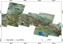
图1
研究区位置示意图"

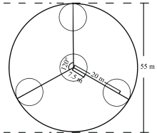
图2
GLAS脚印点样地布局图"


图3
样地调查点分布图 注:底图为从DEM数据中提取的坡度图,所有样地调查点均位于甘肃省境内。"
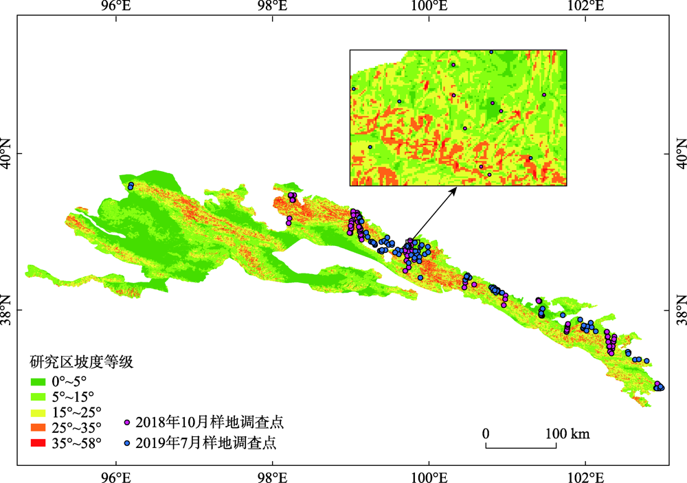
表1
训练样本详细信息"
| 土地覆被类别 | 样本数量/个 | 栅格数量/个 |
|---|---|---|
| 农田 | 100 | 12937 |
| 灌木 | 102 | 9180 |
| 草地 | 132 | 11223 |
| 森林 | 115 | 8511 |
| 针叶林 | 157 | 20567 |
| 阔叶林 | 109 | 16459 |
| 针阔混交林 | 48 | 5769 |
| 建设用地 | 76 | 8360 |
| 裸地 | 103 | 8652 |
| 水域 | 157 | 15563 |
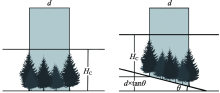
图4
不同地形条件对GLAS提取森林冠层高度的影响 注:HC为实际冠层高度(m);θ为地表坡度(°);d为GLAS脚印直径(m)。"
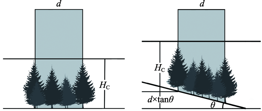
表2
祁连山地区相关树种异速方程和碳含量转换系数"
| 树种 | 异速生长方程 | 参考文献 | 碳含量转换系数 |
|---|---|---|---|
| 青海云杉 Picea crassifolia | | 王金叶等[ | 0.5200[ |
| 祁连圆柏 Juniperus przewalskii | | 王金叶等[ | 0.4650[ |
| 侧柏 Platycladus orientalis | | 关晋宏等[ | 0.5034[ |
| 油松 Pinus tabulaeformis | | 程堂仁等[ | 0.5108[ |
| 蒙古栎 Quercus mongolica | | 关晋宏等[ | 0.5004[ |
| 山杨 Populus davidiana | | 程堂仁等[ | 0.4956[ |
| 白桦 Betula platyphylla | | 程堂仁等[ | 0.5025[ |
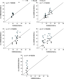
图5
地形校正前后不同坡度等级GLAS冠层高度估计精度对比"
表3
不同坡度等级地形校正前后GLAS提取冠层高度的精度比较"
| 坡度等级 | R2 | RMSE/m | ||
|---|---|---|---|---|
| 校正前 | 校正后 | 校正前 | 校正后 | |
| 0°~5° | 0.62 | 0.66 | 2.83 | 1.84 |
| 5°~15° | 0.64 | 0.65 | 3.32 | 2.23 |
| 15°~25° | 0.66 | 0.67 | 6.74 | 3.51 |
| 25°~35° | 0.63 | 0.65 | 8.00 | 3.91 |
| 35°~58° | 0.65 | 0.67 | 12.59 | 3.48 |
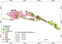
图6
森林区域内GLAS脚印点森林地上碳密度估算结果"

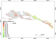
图7
2018年祁连山国家公园森林地上碳密度分布图"

| [1] |
Pan Y, Birdsey R A, Fang J, et al. A large and persistent carbon sink in the world’s forests[J]. Science, 2011, 333(6045):988-993.
doi: 10.1126/science.1201609 |
| [2] |
Houghton R A, House J I, Pongratz J, et al. Carbon emissions from land use and land-cover change[J]. Biogeosciences, 2012, 9(12):5125-5142.
doi: 10.5194/bg-9-5125-2012 |
| [3] |
Shang X, Chazette P. Interest of a full-waveform flown UV Lidar to derive forest vertical structures and aboveground carbon[J]. Forests, 2014, 5(6):1454-1480.
doi: 10.3390/f5061454 |
| [4] |
Narine L L, Popescu S, Neuenschwander A, et al. Estimating aboveground biomass and forest canopy cover with simulated ICESat-2 data[J]. Remote Sensing of Environment, 2019, 224:1-11.
doi: 10.1016/j.rse.2019.01.037 |
| [5] |
Neigh C S R, Nelson R F, Ranson K J, et al. Taking stock of circumboreal forest carbon with ground measurements, airborne and spaceborne LiDAR[J]. Remote Sensing of Environment, 2013, 137:274-287.
doi: 10.1016/j.rse.2013.06.019 |
| [6] |
Wulder M A, White J C, Nelson R F, et al. Lidar sampling for large-area forest characterization: A review[J]. Remote Sensing of Environment, 2012, 121:196-209.
doi: 10.1016/j.rse.2012.02.001 |
| [7] |
Nelson R, Boudreau J, Gregoire T G, et al. Estimating Quebec provincial forest resources using ICESat/GLAS[J]. Canadian Journal of Forest Research, 2009, 39(4):862-881.
doi: 10.1139/X09-002 |
| [8] |
Baccini A, Goetz S J, Walker W S, et al. Estimated carbon dioxide emissions from tropical deforestation improved by carbon-density maps[J]. Nature Climate Change, 2012, 2(3):182-185.
doi: 10.1038/nclimate1354 |
| [9] |
Tyukavina A, Stehman S V, Potapov P V, et al. National-scale estimation of gross forest aboveground carbon loss: A case study of the Democratic Republic of the Congo[J]. Environmental Research Letters, 2013, 8(4):044039, doi: 10.1088/1748-9326/8/4/044039.
doi: 10.1088/1748-9326/8/4/044039 |
| [10] | 池泓, 黄进良, 邱娟, 等. GLAS星载激光雷达和Landsat/ETM+数据的森林生物量估算[J]. 测绘科学, 2018, 43(4):9-16, 23. |
| [ Chi Hong, Huang Jinliang, Qiu Juan, et al. Estimation of forest aboveground biomass using ICESat/GLAS data and Landsat/ETM+ imagery[J]. Science of Surveying and Mapping, 2018, 43(4):9-16, 23. ] | |
| [11] |
Hilbert C, Schmullius C. Influence of surface topography on ICESat/GLAS forest height estimation and waveform shape[J]. Remote Sensing, 2012, 4(8):2210-2235.
doi: 10.3390/rs4082210 |
| [12] |
Saatchi S S, Harris N L, Brown S, et al. Benchmark map of forest carbon stocks in tropical regions across three continents[J]. Proceedings of the National Academy of Sciences of the United States of America, 2011, 108(24):9899-9904.
doi: 10.1073/pnas.1019576108 pmid: 21628575 |
| [13] |
Huang H, Liu C, Wang X, et al. Integration of multi-resource remotely sensed data and allometric models for forest aboveground biomass estimation in China[J]. Remote Sensing of Environment, 2019, 221:225-234.
doi: 10.1016/j.rse.2018.11.017 |
| [14] |
Wang Y, Li G, Ding J, et al. A combined GLAS and MODIS estimation of the global distribution of mean forest canopy height[J]. Remote Sensing of Environment, 2016, 174:24-43.
doi: 10.1016/j.rse.2015.12.005 |
| [15] | 程鹏, 孔祥伟, 罗汉, 等. 近60 a以来祁连山中部气候变化及其径流响应研究[J]. 干旱区地理, 2020, 43(5):1192-1201. |
| [ Cheng Peng, Kong Xiangwei, Luo Han, et al. Climate change and its runoff response in the middle section of the Qilian Mountains in the past 60 years[J]. Arid Land Geography, 2020, 43(5):1192-1201. ] | |
| [16] | 马剑, 刘贤德, 李广, 等. 祁连山北麓中段青海云杉林土壤水热时空变化特征[J]. 干旱区地理, 2020, 43(4):1033-1040. |
| [ Ma Jian, Liu Xiande, Li Guang, et al. Spatial and temporal variations of soil moisture and temperature of Picea crassifolia forest in north piedmont of central Qilian Mountains[J]. Arid Land Geography, 2020, 43(4):1033-1040. ] | |
| [17] | Fang S, He Z, Du J, et al. Carbon mass change and its drivers in a boreal coniferous forest in the Qilian Mountains, China from 1964 to 2013[J]. Forests, 2018, 9(2):f9020057, doi: 10.3390/f9020057. |
| [18] | Yue J W, Guan J H, Deng L, et al. Allocation pattern and accumulation potential of carbon stock in natural spruce forests in northwest China[J]. Peerj, 2018(6):e4859, doi: 10.7717/peerj.4859. |
| [19] | Zwally H J, Schutz R, Hancock D, et al. GLAS/ICESat L2 global land surface altimetry data (HDF5), version 34[DB/OL]. [2014]. NASA National Snow and Ice Data Center Distributed Active Archive Center. |
| [20] |
Chi H, Sun G, Huang J, et al. National forest aboveground biomass mapping from ICESat/GLAS data and MODIS imagery in China[J]. Remote Sensing, 2015, 7(5):5534-5564.
doi: 10.3390/rs70505534 |
| [21] |
Wei L, Feng Q, Deo R C. Changes in climatic elements in the Pan-Hexi region during 1960—2014 and responses to global climatic changes[J]. Theoretical and Applied Climatology, 2018, 133(1-2):405-420.
doi: 10.1007/s00704-017-2194-6 |
| [22] | 王晓学, 沈会涛, 林田苗, 等. 利用多信息源提高半干旱地区TM影像的森林类型制图精度: 以北京西部山区为例[J]. 自然资源学报, 2017, 32(7):1217-1228. |
| [ Wang Xiaoxue, Shen Huitao, Lin Tianmiao, et al. Improving the forest type mapping accuracy in semiarid mountainous areas based on TM images: Take the west mountain of Beijing as an example[J]. Journal of Natural Resources, 2017, 32(7):1217-1228. ] | |
| [23] |
Park T, Kennedy R E, Choi S, et al. Application of physically-based slope correction for maximum forest canopy height estimation using waveform Lidar across different footprint sizes and locations: Tests on LVIS and GLAS[J]. Remote Sensing, 2014, 6(7):6566-6586.
doi: 10.3390/rs6076566 |
| [24] |
Fick S E, Hijmans R J. WorldClim 2: New 1-km spatial resolution climate surfaces for global land areas[J]. International Journal of Climatology, 2017, 37(12):4302-4315.
doi: 10.1002/joc.2017.37.issue-12 |
| [25] |
Lee S, Ni-Meister W, Yang W, et al. Physically based vertical vegetation structure retrieval from ICESat data: Validation using LVIS in White Mountain National Forest, New Hampshire, USA[J]. Remote Sensing of Environment, 2011, 115(11):2776-2785.
doi: 10.1016/j.rse.2010.08.026 |
| [26] | 王金叶, 车克钧, 蒋志荣. 祁连山青海云杉林碳平衡研究[J]. 西北林学院学报, 2000(1):9-14. |
| [ Wang Jinye, Che Kejun, Jiang Zhirong. A study on carbon balance of Picea crassifolia in Qilian Mountains[J]. Journal of Northwest Forestry College, 2000(1):9-14. ] | |
| [27] | 王金叶, 车克钧, 傅辉恩, 等. 祁连山水源涵养林生物量的研究[J]. 福建林学院学报, 1998(4):34-38. |
| [ Wang Jinye, Che Kejun, Fu Hui’en, et al. Study on biomass of water conservation forest on north slope of Qilian Mountains[J]. Journal of FuJian College of Forestry, 1998(4):34-38. ] | |
| [28] | 罗艳, 唐才富, 辛文荣, 等. 青海省云杉属(Picea)和圆柏属(Sabina)乔木含碳率分析[J]. 生态环境学报, 2014, 23(11):1764-1768. |
| [ Luo Yan, Tang Caifu, Xin Wenrong, et al. Carbon content rate of Picea and Sabina trees in Qinghai Province[J]. Ecology and Environmental Sciences, 2014, 23(11):1764-1768. ] | |
| [29] |
关晋宏, 杜盛, 程积民, 等. 甘肃省森林碳储量现状与固碳速率[J]. 植物生态学报, 2016, 40(4):304-317.
doi: 10.17521/cjpe.2016.0017 |
|
[ Guan Jinhong, Du Sheng, Cheng Jimin, et al. Current stocks and rate of sequestration of forest carbon in Gansu Province, China[J]. Chinese Journal of Plant Ecology, 2016, 40(4):304-317. ]
doi: 10.17521/cjpe.2016.0017 |
|
| [30] |
Zhao M, Yue T, Zhao N, et al. Combining LPJ-GUESS and HASM to simulate the spatial distribution of forest vegetation carbon stock in China[J]. Journal of Geographical Sciences, 2014, 24(2):249-268.
doi: 10.1007/s11442-014-1086-2 |
| [31] | 程堂仁, 马钦彦, 冯仲科, 等. 甘肃小陇山森林生物量研究[J]. 北京林业大学学报, 2007(1):31-36. |
| [ Chen Tangren, Ma Qinyan, Feng Zhongke, et al. Research on forest biomass in Xiaolong Mountains, Gansu Province[J]. Journal of Beijing Forestry University, 2007(1):31-36. ] | |
| [32] | 程堂仁, 冯菁, 马钦彦, 等. 甘肃小陇山森林植被碳库及其分配特征[J]. 生态学报, 2008, 28(1):33-44. |
| [ Cheng Tangren, Feng Jing, Ma Qinyan, et al. Carbon pool and allocation of forest vegetations in Xiaolong Mountains, Gansu Province[J]. Acta Ecologica Sinica, 2008, 28(1):33-44. ] | |
| [33] |
Sileshi G W. A critical review of forest biomass estimation models, common mistakes and corrective measures[J]. Forest Ecology and Management, 2014, 329:237-254.
doi: 10.1016/j.foreco.2014.06.026 |
| [34] | 程堂仁. 甘肃小陇山森林生物量及碳储量研究[D]. 北京: 北京林业大学, 2007. |
| [ Cheng Tangren. Research on the forest biomass and carbon storage in Xiaolong Mountains, Gansu Province[D]. Beijing: Beijing Forestry University, 2007. ] | |
| [35] |
Baccini A, Laporte N, Goetz S J, et al. A first map of tropical Africa’s above-ground biomass derived from satellite imagery[J]. Environmental Research Letters, 2008, 3(4):045011, doi: 10.1088/1748-9326/3/4/045011.
doi: 10.1088/1748-9326/3/4/045011 |
| [36] |
Cao L, Pan J, Li R, et al. Integrating airborne LiDAR and optical data to estimate forest aboveground biomass in arid and semi-arid regions of China[J]. Remote Sensing, 2018, 10(4):532, doi: 10.3390/rs10040532.
doi: 10.3390/rs10040532 |
| [37] |
Ei Hajj M, Baghdadi N, Fayad I, et al. Interest of integrating spaceborne LiDAR data to improve the estimation of biomass in high biomass forested areas[J]. Remote Sensing, 2017, 9(3):213, doi: 10.3390/rs9030213.
doi: 10.3390/rs9030213 |
| [38] |
Phillips S J, Anderson R P, Schapire R E. Maximum entropy modeling of species geographic distributions[J]. Ecological Modelling, 2006, 190(3-4):231-259.
doi: 10.1016/j.ecolmodel.2005.03.026 |
| [39] |
Peng J, Liu Z, Liu Y, et al. Trend analysis of vegetation dynamics in Qinghai-Tibet Plateau using Hurst exponent[J]. Ecological Indicators, 2012, 14(1):28-39.
doi: 10.1016/j.ecolind.2011.08.011 |
| [40] |
Wagner B, Liang E, Li X, et al. Carbon pools of semi-arid Picea crassifolia forests in the Qilian Mountains (north-eastern Tibetan Plateau)[J]. Forest Ecology and Management, 2015, 343:136-143.
doi: 10.1016/j.foreco.2015.02.001 |
| [41] | 巫明焱, 董光, 王艺积, 等. 川西米亚罗自然保护区森林地上碳储量遥感估算[J]. 生态学报, 2020, 40(2):621-628. |
| [ Wu Mingyan, Dong Guang, Wang Yiji, et al. Estimation of forest aboveground carbon storage in Sichuan Miyaluo Nature Reserve based on remote sensing[J]. Acta Ecologica Sinica, 2020, 40(2):621-628. ] | |
| [42] | 穆喜云, 刘清旺, 庞勇, 等. 基于机载激光雷达的森林地上碳储量估测[J]. 东北林业大学学报, 2016, 44(11):52-56. |
| [ Mu Xiyun, Liu Qingwang, Pang Yong, et al. Forest aboveground carbon storage using RF algorithmic model and airborne LiDAR data[J]. Journal of Northeast Forestry University, 2016, 44(11):52-56. ] | |
| [43] |
Wu J, Wang X, Zhang H, et al. Development of a forest canopy height estimation model using GLAS full waveform data over sloping terrain[J]. International Journal of Remote Sensing, 2018, 39(23):9073-9091.
doi: 10.1080/01431161.2018.1506181 |
| [44] | 胡凯龙, 刘清旺, 庞勇, 等. 基于机载激光雷达校正的ICESat/GLAS数据森林冠层高度估测[J]. 农业工程学报, 2017, 33(16):88-95. |
| [ Hu Kailong, Liu Qingwang, Pang Yong, et al. Forest canopy height estimation based on ICESat/GLAS data by airborne Lidar correction[J]. Transactions of the Chinese Society of Agricultural Engineering, 2017, 33(16):88-95. ] | |
| [45] |
Liu K, Wang J, Zeng W, et al. Comparison and evaluation of three methods for estimating forest above ground biomass using TM and GLAS data[J]. Remote Sensing, 2017, 9(4):341, doi: 10.3390/rs9040341.
doi: 10.3390/rs9040341 |
| [1] | 冯宜明, 吕春燕, 王零, 赵维俊, 马雪娥, 杜军林, 何俊龄. 不同林分密度青海云杉林碳氮储量及其分配格局[J]. 干旱区地理, 2023, 46(7): 1133-1144. |
| [2] | 芦雄英, 刘贤德, 马瑞, 赵维俊, 敬文茂, 何晓玲, 赵长兴. 祁连山排露沟流域青海云杉林更新特征对地形因子的响应[J]. 干旱区地理, 2023, 46(4): 604-613. |
| [3] | 尚海洋,宋妮妮. 返贫风险、生计抵御力与规避策略实践——祁连山国家级自然保护区内8县的调查与分析[J]. 干旱区地理, 2021, 44(6): 1784-1795. |
| [4] | 温煜华,吕越敏,李宗省. 近60a祁连山极端降水变化研究[J]. 干旱区地理, 2021, 44(5): 1199-1212. |
| [5] | 马剑,刘贤德,何晓玲,王顺利,贺永岩,武秀荣,赵晶忠,马雪娥. 祁连山典型灌丛群落结构特征及其多样性研究[J]. 干旱区地理, 2021, 44(5): 1427-1437. |
| [6] | 孙美平,史继花,姚晓军,张海瑜,赵琳林,马维谦. 冰川下垫面对夏季云结构和云水含量的影响——以祁连山区疏勒南山为例[J]. 干旱区地理, 2021, 44(1): 141-148. |
| [7] | 张坤, 肖燕, 何振芳, 高敏 . 基于 SRTM DEM 的祁连山自然保护区地形特征研究[J]. 干旱区地理, 2020, 43(6): 1559-1566. |
| [8] | 刘佳茹, 赵军, 沈思民, 赵彦军. 基于 SRP 概念模型的祁连山地区生态脆弱性评价[J]. 干旱区地理, 2020, 43(6): 1573-1582. |
| [9] | 程鹏, 孔祥伟, 罗 汉, 李宝梓, 王研峰 . 近 60 a 以来祁连山中部气候变化及其径流响应研究[J]. 干旱区地理, 2020, 43(5): 1192-1201. |
| [10] | 王清涛, 赵传燕, 王小平, 胡姗姗, 刘美艳, 史文宇, 王晓雨, 单文荣 . 基于 FAREAST 模型的青海云杉中-幼龄林生物量 碳沿海拔梯度分布特征[J]. 干旱区地理, 2020, 43(5): 1316-1326. |
| [11] | 马剑, 刘贤德, 李广, 赵维俊, 王顺利, 敬文茂, 马雪娥. 祁连山北麓中段青海云杉林土壤水热时空变化特征[J]. 干旱区地理, 2020, 43(4): 1033-1040. |
| [12] | 邱丽莎, 何毅, 张立峰, 王文辉, 唐源蔚. 祁连山MODIS LST时空变化特征及影响因素分析 [J]. 干旱区地理, 2020, 43(3): 726-737. |
| [13] | 赵建林, 康德奎, 彭维恩, 王建礼, 史中兴, 陈天顺, 董志洋, 汪杰, 常兆丰. 景电灌区移民对祁连山植被恢复的相对生态价值[J]. 干旱区地理, 2020, 43(1): 182-189. |
| [14] | 马剑, 刘贤德, 李广, 赵维俊, 王顺利, 敬文茂, 王荣新, 赵永宏. 祁连山中段青海云杉林土壤肥力质量评价研究[J]. 干旱区地理, 2019, 42(6): 1368-1377. |
| [15] | 马兴刚, 贾文雄, 丁 丹, 朱国锋, 巩宁刚, 徐秀婷, 袁瑞丰. 祁连山东部大气降水δ17O变化特征及水汽输送 [J]. 干旱区地理, 2019, 42(3): 517-525. |
| Viewed | ||||||||||||||||||||||||||||||||||||||||||||||||||
|
Full text 539
|
|
|||||||||||||||||||||||||||||||||||||||||||||||||
|
Abstract 430
|
|
|||||||||||||||||||||||||||||||||||||||||||||||||
Cited |
|
|||||||||||||||||||||||||||||||||||||||||||||||||
| Shared | ||||||||||||||||||||||||||||||||||||||||||||||||||
|
||