- 2025年8月2日 星期六
干旱区地理 ›› 2021, Vol. 44 ›› Issue (2): 460-470.doi: 10.12118/j.issn.1000–6060.2021.02.17
李灏欣1( ),万华伟2,孙林1,刘玉平2(),李利平3,王永财2
收稿日期:2020-11-10
修回日期:2021-02-07
出版日期:2021-03-25
发布日期:2021-04-14
通讯作者:
刘玉平
作者简介:李灏欣(1994-),男,在读硕士研究生,主要从事生态遥感方向研究. E-mail:基金资助:
LI Haoxin1(),WAN Huawei2,SUN Lin1,LIU Yuping2(),LI Liping3,WANG Yongcai2
Received:2020-11-10
Revised:2021-02-07
Online:2021-03-25
Published:2021-04-14
Contact:
Yuping LIU
摘要:
作为我国陆地面积最大的省级行政区,新疆维吾尔自治区具有多样的生态系统结构和丰富的动植物物种资源,是我国西北地区重要的生物多样性热点研究区域。通过以新疆维吾尔自治区为研究对象,结合区域特点和定量遥感数据实时、易获取、周期性等优势,选取归一化植被指数、动物物种丰富度、干旱度、人类扰动指数四类单因子指标,依据“活力-组织-恢复力”生态健康评估模型,定量化的构建了新疆以遥感数据为主导的区域综合生态健康遥感评估指数,并进一步基于地理探测器探明不同环境驱动因子对新疆生态健康的影响程度,在县级行政区层面对该方法进行了长时间序列的应用分析和验证。结果表明:(1) 新疆生态健康水平以塔里木河—叶尔羌河流域为分界线,北疆生态健康水平明显高于南疆,具有显著的空间分异性和集聚特征。(2) 各环境因子对新疆生态健康的影响程度依次为:归一化植被指数(0.645)>人类扰动指数(0.512)>动物物种丰富度(0.414)>干旱度(0.116)。(3) 2000—2018年新疆整体生态健康水平呈现逐步攀升的趋势,变化最为显著的区域是在昌吉回族自治州的玛纳斯县、呼图壁县以及昌吉市;阿勒泰地区的福海县和富蕴县。
李灏欣,万华伟,孙林,刘玉平,李利平,王永财. 新疆生态系统健康遥感评估及关键驱动因子研究[J]. 干旱区地理, 2021, 44(2): 460-470.
LI Haoxin,WAN Huawei,SUN Lin,LIU Yuping,LI Liping,WANG Yongcai. Remote sensing assessment and key driving factors of ecosystem health in Xinjiang[J]. Arid Land Geography, 2021, 44(2): 460-470.

图1
新疆土地覆盖分类示意图"

表1
数据来源及基本信息"
| 基础数据 | 数据来源 | 空间分辨率 | 合成方式 | 时间 |
|---|---|---|---|---|
| 归一化植被指数 | MOD13 A2产品 | 1 km | 16 d合成 | 2000、2010、2018年6—9月 |
| 地表温度 | MOD11 A2产品 | 1 km | 8 d合成 | 2000、2010、2018年6—9月 |
| 土地覆盖类型 | 2000、2010、2018年全国30 m分辨率土地覆盖分类数据 | 30 km | 最邻近内插法合成 | 2000、2010、2018年6—9月 |
| 动物物种丰富度 | 文献资料查询 | 10 km | 统计合成 | 2010年 |
表2
多元共线性诊断结果"
| 指标 | 方差膨胀因子(VIF) | 容忍度(TOL) |
|---|---|---|
| 归一化植被指数 | 1.918 | 0.521 |
| 动物物种丰富度 | 1.242 | 0.805 |
| 人类扰动指数 | 1.521 | 0.657 |
| 干旱度 | 1.269 | 0.788 |
表3
新疆不同土地覆被类型的建设用地当量折算系数"
| 土地利用/覆被类型 | CI值 | 土地利用/覆被类型 | CI值 |
|---|---|---|---|
| 耕地 | 0.200 | 低覆盖改良草地 | 0.067 |
| 水田 | 0.200 | 水库池塘 | 0.600 |
| 旱地 | 0.200 | 城镇用地 | 1.000 |
| 高覆盖改良草地 | 0.067 | 农村居民点 | 1.000 |
| 中覆盖改良草地 | 0.067 | 建设用地 | 1.000 |
表4
新疆生态健康遥感评估指标体系"
| 目标层 | 准则层 | 指标层 | 属性 |
|---|---|---|---|
| 新疆生态健康(EH) | 活力(EV) | 归一化植被指数(NDVI) | 正向 |
| 组织力(EO) | 动物物种丰富度(ASR) | 正向 | |
| 恢复力(ER) | 人类扰动指数(HDI) | 负向 | |
| 干旱度(DI) | 负向 |
表5
自变量因子对因变量交互作用的类型"
| 判据 | 交互作用 |
|---|---|
                 | 非线性减弱 |
  | 单因子非线性减弱 |
 | 双因子增强 |
 | 独立 |
| 非线性增强 |
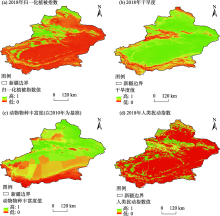
图2
单因子指标空间分布示意图"

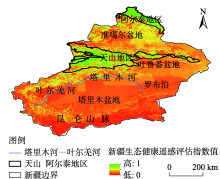
图3
2018年新疆生态健康遥感评估指数示意图"

表6
因子探测分析结果"
| 单因子指标 | 影响力(q) | 解释力(p) | 影响力排序 |
|---|---|---|---|
| 归一化植被指数 | 0.645 | 0.00 | 1 |
| 动物物种丰富度 | 0.414 | 0.00 | 3 |
| 人类扰动指数 | 0.512 | 0.00 | 2 |
| 干旱度 | 0.116 | 0.00 | 4 |
表7
交互作用探测分析结果"
| 交互指标 | 交互关系 |
|---|---|
| NDVI | 双因子增强 |
| NDVI | 双因子增强 |
| NDVI | 双因子增强 |
| 人类扰动指数 | 双因子增强 |
| 人类扰动指数 | 双因子增强 |
| 干旱度 | 非线性增强 |

图4
各年县域生态健康遥感评估分级示意图"

表8
2000—2018年单因子指标及生态健康评估指数均值"
| 年份 | 归一化植被指数 | 动物物种丰富度 | 干旱度 | 人类扰动指数 | 生态健康评估指数 |
|---|---|---|---|---|---|
| 2000 | 0.20 | 0.55 | 0.64 | 0.25 | 0.027 |
| 2010 | 0.34 | 0.55 | 0.63 | 0.28 | 0.035 |
| 2018 | 0.32 | 0.55 | 0.60 | 0.26 | 0.037 |
| [1] | Chiu G S, Guttorp P, Westveld A H, et al. Latent health factor index: A statistical modeling approach for ecological health assessment[J]. Environmetrics, 2011,22(3):243-255. |
| [2] | Armah F A, Luginaah I, Essandoh P K, et al. Ecological health status of the Fosu Lagoon Southern Ghana I: Biotic assessment[J]. Journal of Ecosystem & Ecography, 2012,2(1):433-441. |
| [3] | Patil G P, Myers Wayne L. Environmental and ecological health assessment of landscapes and watersheds with remote sensing data[J]. Ecosyst Health, 1999,4(5):221-224. |
| [4] | Sheldon F. Incorporating natural variability into the assessment of ecological health in Australian dryland rivers[J]. Hydro Biologia, 2005,552(1):45-56. |
| [5] | 徐菲, 王永刚, 张楠, 等. 北京市白河和潮河流域生态健康评价[J]. 生态学报, 2017,37(3):932-942. |
| [ Xu Fei, Wang Yonggang, Zhang Nan, et al. Health assessment of watershed ecosystems[J]. Chinese Journal of Ecology, 2017,37(3):932-942. ] | |
| [6] | James R K, Kurt D F, Paul L A, et al. Assessing biological integrity in running waters: A method and its rationale[J]. Special Publication, 1986,12(5):312-319. |
| [7] | 杨斌, 隋鹏, 陈源泉, 等. 生态系统健康评价研究进展[J]. 中国农学通报, 2010,26(21):291-296. |
| [ Yang Bin, Sui Peng, Chen Yuanquan, et al. Progress in ecosystem health assessment[J]. Chinese Agricultural Science Bulletin, 2010,26(21):291-296. ] | |
| [8] | 黄和平, 杨劼, 毕军. 生态系统健康研究综述与展望[J]. 环境污染与防治, 2006,28(10):768-771. |
| [ Huang Heping, Yang Jie, Bi Jun. Review on ecosystem health research[J]. Environmental Pollution & Control, 2006,28(10):768-771. ] | |
| [9] | 谭娟, 王卿, 沙晨燕, 等. 基于指标体系法的生态系统健康评价[J]. 中国人口资源与环境, 2012,22(增刊1):352-355. |
| [ Tan Juan, Wang Qing, Sha Chenyan, et al. Studies on ecosystem health assessment based on index system method[J]. China Population, Resources and Environment, 2012,22(Suppl. 1):352-355. ] | |
| [10] | Benjamin S H, Catherine L, Darren H, et al. An index to assess the health and benefits of the global ocean[J]. Nature, 2012,488(3):615-620. |
| [11] | Langat D K, Maranga E K, Aboud A A, et al. Role of forest resources to local livelihoods: The case of east Mau forest ecosystem, Kenya[J]. International Journal of Forestry Research, 2016,216:1-10. |
| [12] | 王立新, 刘钟龄, 刘华民, 等. 内蒙古典型草原生态系统健康评价[J]. 生态学报, 2008,28(2):544-550. |
| [ Wang Lixin, Liu Zhongling, Liu Huamin, et al. Assessment of typical steppe ecosystem health in Inner Mongolia[J]. Chinese Journal of Ecology, 2008,28(2):544-550. ] | |
| [13] | HJ/T 192-2006. 生态环境状况评价技术规范(试行)[S]. 北京: 中国环境科学出版社出版发行, 2006. |
| [ HJ/T 192-2006. Technical specification for eco-environmental assessment (trial)[S]. Beijing: China Environmental Science Press, 2006. ] | |
| [14] | 徐涵秋. 城市遥感生态指数的创建及其应用[J]. 生态学报, 2012,33(24):7853-7862. |
| [ Xu Hanqiu. A remote sensing urban ecological index and its application[J]. Acta Ecologica Sinica, 2012,33(24):7853-7862. ] | |
| [15] | 周雪欣, 罗昊. 基于GIS与RS技术的北盘江流域生态环境质量评价研究[J]. 环境科学与管理, 2018,248(7):182-186. |
| [ Zhou Xuexin, Luo Hao. Ecological environment quality evaluation of Beipanjiang River Basin based on GIS and RS technology[J]. Environmental Science and Management, 2018,248(7):182-186. ] | |
| [16] | 刘索玄, 袁艳斌, 赵皞, 等. 基于遥感生态指数(RSEI)的水电开发区生态环境变化分析: 以清江中下游地区为例[J]. 生态与农村环境学报, 2019,35(11):1361-1368. |
| [ Liu Suoxuan, Yuan Yanbin, Zhao Hao, et al. Analysis of ecological environment changes in hydropower development zone based on RSEI: A case study in the middle and lower reaches of the Qingjiang River, China[J]. Journal of Ecology and Rural Environment, 2019,35(11):1361-1368. ] | |
| [17] | 宋媛, 石惠春, 谢敏慧, 等. 2000—2017年甘肃省生态环境质量时空演变格局及其影响因素[J]. 生态学杂志, 2019,38(12):3800-3808. |
| [ Song Yuan, Shi Huichun, Xie Minhui, et al. Spatiotemporal evolution pattern and influencing factors of eco-environmental quality in Gansu from 2000 to 2017[J]. Chinese Journal of Ecology, 2019,38(12):3800-3808. ] | |
| [18] | 邓力琛, 刘寿东, 赵小艳. 基于MOD13A2数据的长三角区域土地覆盖类型变化研究[J]. 中国科技论文, 2015,10(15):1822-1827. |
| [ Deng Lishen, Liu Shoudong, Zhao Xiaoyan. Study on the change in land cover of Yangtze River Delta based on MOD13A2 data[J]. China Science Paper, 2015,10(15):1822-1827. ] | |
| [19] | Zhou G Q, Kang C L, Wang Y F, et al. Characteristics of urban heat island distribution in Guangxi Beibu Gulf Economic Zone based on MOD11A2[C]// International Conference on Intelligent Earth Observing & Applications. International Society for Optics and Photonics, 2015: 814-980. |
| [20] | 夏列钢, 骆剑承, 王卫红, 等. 遥感信息图谱支持的土地覆盖自动分类[J]. 遥感学报, 2014,18(4):788-803. |
| [ Xia Liegang, Luo Jiancheng, Wang Weihong, et al. Land cover automatic classification based on RS-Informatic Tupu[J]. Journal of Remote Sensing, 2014,18(4):788-803. ] | |
| [21] | 马鸣. 新疆鸟类名录[M]. 北京: 科学出版社, 2002: 41-62. |
| [ Ma Ming. Xinjiang bird list[M]. Beijing: Science Press, 2002: 41-62. ] | |
| [22] | 阿布力米提. 新疆哺乳类(兽纲)名录[M]. 北京: 科学出版社, 2002: 10-33. |
| [ Abulimiti. Catalogue of mammals (animal class) in Xinjiang[M]. Beijing: Science Press, 2002: 10-33. ] | |
| [23] | 李利平, 尹林克, 唐志尧. 新疆野生动植物物种丰富度的分布格局[J]. 干旱区研究, 2011,28(1):1-9. |
| [ Li Liping, Yin Linke, Tang Zhirao. Distribution patterns of the species richness of plants and animals in Xinjiang, China[J]. Arid Zone Research. 2011,28(1):1-9. ] | |
| [24] | Lu F, Li Z. A model of ecosystem health and its application[J]. Ecological Modelling, 2003,170(1):55-59. |
| [25] |
Pantus F, Dennidon W. Quantifying and evaluating ecosystem health: A case study from Moreton Bay, Australia[J]. Environmental Management, 2005,36(5):757-771.
doi: 10.1007/s00267-003-0110-6 pmid: 16206027 |
| [26] | 欧阳晓, 朱翔, 贺清云. 基于生态系统服务和生态系统健康的生态风险评价: 以长株潭城市群为例[J]. 生态学报, 2020,40(16):5478-5489. |
| [ Ouyang Xiao, Zhu Xiang, He Qingyun. Incorporating ecosystem services with ecosystem health for ecological risk assessment: Case study in Changsha, Zhuzhou and Xiangtan urban agglomeration, China[J]. Chinese Journal of Ecology, 2020,40(16):5478-5489. ] | |
| [27] | Samuel N, Goward, Czajkowski K P, et al. Evaluating land surface moisture conditions from the remotely sensed temperature/vegetation index measurements: An exploration with the simplified simple biosphere model[J]. Remote Sensing of Environment, 2002,79(2/3):225-242. |
| [28] | Peng J, Liu Y, Li T, et al. Regional ecosystem health response to rural land use change: A case study in Lijiang City, China[J]. Ecological Indicators, 2017,72:399-410. |
| [29] | 倪永明. 新疆荒漠生态系统评价及其综合治理模式[D]. 北京: 中国科学院生态环境研究中心, 2005. |
| [ Ni Yongming. Evaluation of desert ecosystem in Xinjiang and its comprehensive management model[D]. Beijing: Research Center for Eco-Environmental Sciences, Chinese Academy of Sciences, 2005. ] | |
| [30] | 黄莹, 包安明, 刘海隆, 等. 基于景观格局的新疆生态脆弱性综合评价研究[J]. 干旱地区农业研究, 2009,27(3):261-266. |
| [ Huang Ying, Bao Anming, Liu Hailong, et al. Analysis of ecological vulnerability in Xinjiang based on its landscape pattern[J]. Agricultural Research in the Arid Areas, 2009,27(3):261-266. ] | |
| [31] | 黄明, 张学霞, 张建军, 等. 基于CLUE-S模型的罗玉沟流域多尺度土地利用变化模拟[J]. 资源科学, 2012,34(4):769-776. |
| [ Huang Ming, Zhang Xuexia, Zhang Jianjun, et al. A multi-scale simulation of land use change in Luoyugou Watershed based on CLUE-S model[J]. Resources Science, 2012,34(4):769-776. ] | |
| [32] | 何宝忠, 丁建丽, 李焕, 等. 新疆植被物候时空变化特征[J]. 生态学报, 2018,38(6):2139-2155. |
| [ He Baozhong, Ding Jianli, Li Huan, et al. Spatiotemporal variation of vegetation phenology in Xinjiang from 2001 to 2016[J]. Acta Ecologica Sinica, 2018,38(6):2139-2155. ] | |
| [33] | 尼加提·伊米尔, 满苏尔·沙比提, 玉苏甫·买买提. 天山北坡植被NDVI时空变化及其与气候因子的关系[J]. 干旱区研究, 2019,36(5):205-215. |
| [ Nijiati Yimier, Mansuer Shabiti, Yusupu Maimaiti. Spatiotemporal variation of vegetation NDVI and its relationship with climatic factors on the northern slope of the Tianshan Mountains[J]. Arid Zone Research, 2019,36(5):205-215. ] | |
| [34] | 杨怡, 吴世新, 庄庆威, 等. 2000—2018年古尔班通古特沙漠EVI时空变化特征[J]. 干旱区研究, 2019,36(6):191-199. |
| [ Yang Yi, Wu Shixin, Zhuang Qingwei, et al. Spatiotemporal change of EVI in the Gurbantunggut Desert from 2000 to 2018[J]. Arid Zone Research, 2019,36(6):191-199. ] | |
| [35] | 李海霞, 杨井, 陈亚宁, 等. 基于MODIS数据的新疆地区土壤湿度反演[J]. 草业学报, 2017,26(6):16-27. |
| [ Li Haixia, Yang Jing, Chen Yaning, et al. Retrieval of soil moisture information in Xinjiang using MODIS[J]. Acta Prataculturae Sinica, 2017,26(6):16-27. ] | |
| [36] | 陈丙寅, 杨辽, 陈曦, 等. 基于改进型TVDI在干旱区旱情监测中的应用研究[J]. 干旱区地理, 2019,42(4):902-913. |
| [ Chen Bingyin, Yang Liao, Chen Xi, et al. Application of modified TVDI in drought monitoring in arid areas[J]. Arid Land Geography, 2019,42(4):902-913. ] | |
| [37] | 高瑜莲, 柳锦宝, 柳维扬, 等. 近14 a新疆南疆绿洲地区地表蒸散与干旱的时空变化特征研究[J]. 干旱区地理, 2019,42(4):830-837. |
| [ Gao Yulian, Liu Jinbao, Liu Weiyang, et al. Spatio-temporal variation characteristics of surface evapotranspiration and drought at the oasis area of the southern Xinjiang in recent 14 years[J]. Arid Land Geography, 2019,42(4):830-837. ] | |
| [38] | 徐勇, 孙晓一, 汤青. 陆地表层人类活动强度: 概念、方法及应用[J]. 地理学报, 2015,70(7):46-57. |
| [ Xu Yong, Sun Xiaoyi, Tang Qing. Human activity intensity of land surface: Concept, method and application in China[J]. Acta Geographica Sinica, 2015,70(7):46-57. ] | |
| [49] | 王劲峰, 徐成东. 地理探测器:原理与展望[J]. 地理学报, 2017,72(1):116-134. |
| [ Wang Jinfeng, Xu Chengdong. Geodetector: Principle and prospective[J]. Acta Geographica Sinica, 2017,72(1):116-134. ] | |
| [40] | 郭泽呈, 魏伟, 庞素菲, 等. 基于SPCA和遥感指数的干旱内陆河流域生态脆弱性时空演变[J]. 生态学报, 2019,39(7):296-310. |
| [ Guo Zecheng, Wei Wei, Pang Sufei, et al. Spatiotemporal evolution pattern and influencing factors of eco-environmental quality in Gansu from 2000 to 2017[J]. Chinese Journal of Ecology, 2019,39(7):296-310. ] | |
| [41] | 佚名. 2017年中国生态环境状况公报[R]. 北京: 生态环境部, 2018. |
| [ Anonymity. The state of China’s ecological environment in 2017[R]. Beijing: Ministry of Ecology and Environment of the People’s Repoblic of China, 2018. ] | |
| [42] | 周紫燕, 汪小钦. 新疆生态质量变化趋势遥感分析[J]. 生态学报, 2019,40(9):1-13. |
| [ Zhou Ziyan, Wang Xiaoqin. Remote sensing analysis of ecological quality change in Xinjiang[J]. Chinese Journal of Ecology, 2019,40(9):1-13. ] | |
| [43] | 韩鑫, 王玥, 刘传胜, 等. 新疆天山自然遗产地景观格局动态演化及其生态健康评价[J]. 干旱区地理, 2019,42(1):195-205. |
| [ Han Xin, Wang Yue, Liu Chuansheng, et al. Dynamic evolution of landscape pattern and ecological health assessment of Tianshan Natural Heritage Site in Xinjiang[J]. Arid Land Geography, 2019,42(1):195-205. ] |
| [1] | 杨雨, 宋福铁, 张杰. 基于地理探测器的中国金融网络空间结构特征及影响因素研究[J]. 干旱区地理, 2023, 46(9): 1524-1535. |
| [2] | 李建辉, 陈琳, 党争. 黄河流域爱国主义教育基地空间格局及影响因素研究[J]. 干旱区地理, 2023, 46(9): 1536-1544. |
| [3] | 张昊, 韩增林, 乔国荣, 王辉, 王宏业, 段冶. 黄河流域城市间旅游经济联系格局及影响因素研究[J]. 干旱区地理, 2023, 46(8): 1344-1354. |
| [4] | 康利刚, 曹生奎, 曹广超, 严莉, 陈链璇, 李文斌, 赵浩然. 青海湖流域地表温度时空变化特征研究[J]. 干旱区地理, 2023, 46(7): 1084-1097. |
| [5] | 夏文浩, 王铭扬, 姜磊. 新疆农业碳排放强度时空变化趋势与收敛分析[J]. 干旱区地理, 2023, 46(7): 1145-1154. |
| [6] | 姚岚博, 冶建明, 王芸, 朱现伟. 干旱区人居环境系统耦合协调的时空演变及作用机制研究——以新疆为例[J]. 干旱区地理, 2023, 46(6): 1013-1023. |
| [7] | 杨锐, 李建勇, 王宁练, 陈小俊, 杜建峰, 刘剑波, 韩岳婷. 西天山温泉地区全新世沉积物元素地球化学记录及其古环境意义[J]. 干旱区地理, 2023, 46(6): 900-910. |
| [8] | 穆佳薇, 乔保荣, 余国新. 新疆塔里木河流域县域农业低碳生产率时空格局及影响效应研究[J]. 干旱区地理, 2023, 46(6): 968-981. |
| [9] | 孔德明, 郝丽莎, 夏四友, 李红波. 粮食单产视角下中国北方农牧交错带粮食安全研究[J]. 干旱区地理, 2023, 46(5): 782-792. |
| [10] | 张烈琴, 陆亦农, 龙震, 李庆雷, 王涛. 新疆文化旅游空间分布格局[J]. 干旱区地理, 2023, 46(5): 823-833. |
| [11] | 罗嘉艳, 张靖, 徐梦冉, 莫宇, 同丽嘎. 浑善达克沙地植被变化定量归因及多情景预测[J]. 干旱区地理, 2023, 46(4): 614-624. |
| [12] | 朱磊, 李燕楠, 胡静, 田小波, 徐佳慧, 卿琪. 中国研学实践基地空间格局的多尺度特征及影响机理研究[J]. 干旱区地理, 2023, 46(4): 625-635. |
| [13] | 闫新杰, 孙慧, 辛龙. 新疆资源型企业的空间分布与区位选择[J]. 干旱区地理, 2023, 46(4): 678-687. |
| [14] | 张宁,汪子晨,杨肖,陈彤,邢飞. 新疆水资源与农业种植系统耦合协调及时空差异研究——以粮食和棉花种植系统为例[J]. 干旱区地理, 2023, 46(3): 349-359. |
| [15] | 杨玉欢,贺建雄,张新红,芮旸. 中国农文旅耦合协调发展空间分异特征及影响肌理[J]. 干旱区地理, 2023, 46(3): 448-459. |
| Viewed | ||||||||||||||||||||||||||||||||||||||||||||||||||
|
Full text 121
|
|
|||||||||||||||||||||||||||||||||||||||||||||||||
|
Abstract 501
|
|
|||||||||||||||||||||||||||||||||||||||||||||||||
Cited |
|
|||||||||||||||||||||||||||||||||||||||||||||||||
| Shared | ||||||||||||||||||||||||||||||||||||||||||||||||||
|
||