干旱区地理 ›› 2026, Vol. 49 ›› Issue (4): 816-829.doi: 10.12118/j.issn.1000-6060.2025.238 cstr: 32274.14.ALG2025238
张靖欣1( ), 周磊1(), 胡森苗1, 于杨1, 刘京会2, 武建军3
收稿日期:2025-05-06
修回日期:2025-05-26
出版日期:2026-04-25
发布日期:2026-04-28
通讯作者:
周磊(1983-),男,博士,教授,主要从事灾害与环境遥感等方面的研究. E-mail: zhoulei@bucea.edu.cn作者简介:张靖欣(1999-),女,硕士研究生,主要从事灾害风险评估等方面的研究. E-mail: 2108160323005@stu.bucea.edu.cn
基金资助:
ZHANG Jingxin1(), ZHOU Lei1(), HU Senmiao1, YU Yang1, LIU Jinghui2, WU Jianjun3
Received:2025-05-06
Revised:2025-05-26
Published:2026-04-25
Online:2026-04-28
摘要:
风险区划作为灾害风险管理的关键手段,对于精准识别灾害风险、科学调配防灾资源具有重要意义。基于自然地理数据、灾情统计数据以及科考调查数据,按照“孕灾环境敏感性-自然灾害影响显著性-灾害风险等级”3级体系构建风险区划模型,在典型流域新疆伊犁河流域以1 km格网为最小单元针对流域内主要灾害类型进行综合风险区划。通过选取3类因子对应的12个评价指标,划分出3个孕灾环境敏感区,9个自然灾害显著影响区以及26个综合风险区,并从实测数据及调查问卷2方面验证了结果的准确性。结果表明:(1) 伊犁河流域内灾害综合风险分布呈现东高西低的趋势,具有显著的空间差异性。(2) 流域内多种灾害频发,主要涉及到的灾害类型包含洪涝、地质灾害、干旱以及雪灾等。(3) 区划结果在整体空间分布以及典型灾害类型表征上与历史数据及相关研究具有一致性。区别于全国灾害风险普查的相对宏观性,聚焦流域尺度,结合独特的地质构造、气候特征等孕灾环境,深度剖析特定的灾害类型,构建适配当地实际情况的风险区划体系,便于切实提升当地灾害风险管理的精准性与有效性,保障地区内生态经济可持续发展。
张靖欣, 周磊, 胡森苗, 于杨, 刘京会, 武建军. 适用于流域尺度精准灾害管理的综合风险区划[J]. 干旱区地理, 2026, 49(4): 816-829.
ZHANG Jingxin, ZHOU Lei, HU Senmiao, YU Yang, LIU Jinghui, WU Jianjun. Integrated risk zoning for accurate disaster management at the watershed scale[J]. Arid Land Geography, 2026, 49(4): 816-829.
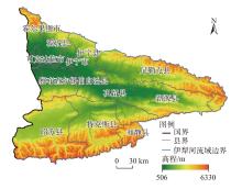
图1
研究区示意图 注:基于自然资源部标准地图服务网站审图号为GS(2019)3333号的标准地图制作,底图边界无修改。下同。"
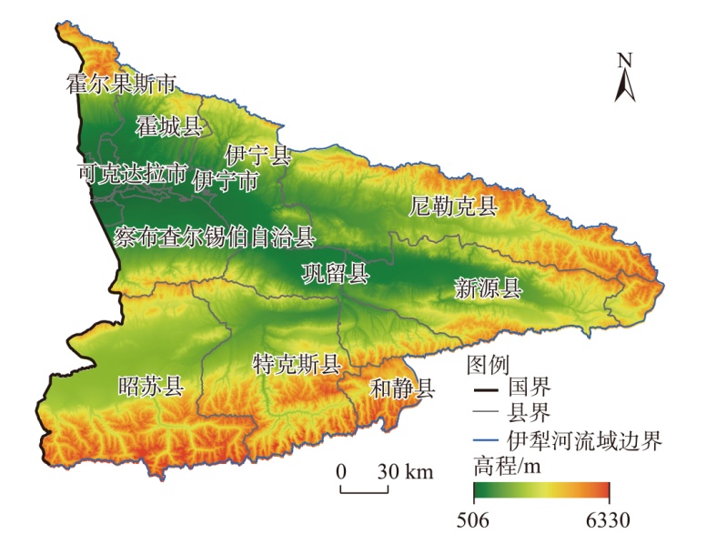
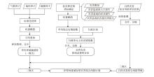
图2
伊犁河流域自然灾害综合风险区划技术路线"
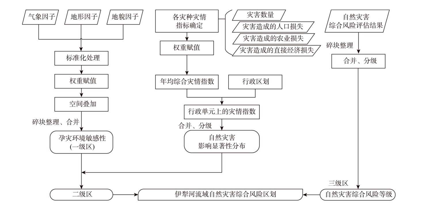
表1
层次分析法-随机一致性指标"
| n | 1 | 2 | 3 | 4 | 5 | 6 | 7 | 8 | 9 | 10 | … |
|---|---|---|---|---|---|---|---|---|---|---|---|
| RI | 0.00 | 0.00 | 0.52 | 0.89 | 1.12 | 1.26 | 1.36 | 1.41 | 1.46 | 1.49 | … |
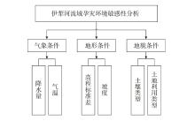
图3
伊犁河流域孕灾环境敏感性指标体系"
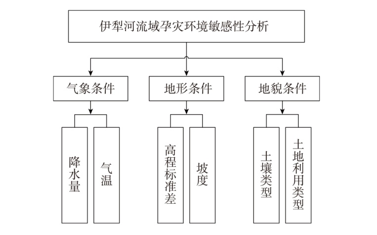
表2
伊犁河流域孕灾环境敏感性指标权重计算结果"
| 目标层 | 准则层 | 准则层权重 | 指标层 | 指标层权重 | 一致性指标 | 一致性比率 |
|---|---|---|---|---|---|---|
| 敏感性指标 | 气象条件 | 0.481 | 降水量 | 0.401 | 0.011 | 0.009 |
| 气温 | 0.080 | |||||
| 地形条件 | 0.430 | 高程标准差 | 0.263 | |||
| 坡度 | 0.167 | |||||
| 地貌条件 | 0.089 | 土壤类型 | 0.054 | |||
| 土地利用类型 | 0.035 |
表3
伊犁河流域自然灾害综合影响指标权重计算结果"
| 目标层 | 准则层 | 准则层权重 | 指标层 | 指标层权重 | 一致性指标 | 一致性比率 |
|---|---|---|---|---|---|---|
| 灾害影响显著性指标 | 灾害数量 | 0.048 | 灾害数量 | 0.048 | 0.012 | 0.009 |
| 人口 | 0.410 | 受灾人口占比 | 0.151 | |||
| 死亡人口占比 | 0.259 | |||||
| 农业 | 0.240 | 农作物受灾面积占比 | 0.105 | |||
| 农作物绝收面积占比 | 0.125 | |||||
| 经济损失 | 0.312 | 直接经济损失 | 0.312 |
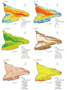
图4
孕灾环境敏感性指标因子"

表4
伊犁河流域孕灾环境敏感性指标分级"
| 指标层 | 极低敏感性 | 低敏感性 | 中等敏感性 | 高敏感性 | 极高敏感性 | 权重 |
|---|---|---|---|---|---|---|
| 降水量/mm | <201 | 202~250 | 251~300 | 301~375 | 376~525 | 0.397 |
| 气温/℃ | <-4.00 | -3.90~-0.25 | -0.24~3.60 | 3.61~7.80 | 7.81~12.30 | 0.080 |
| 高程标准差/m | <2.000 | 2.001~8.000 | 8.001~15.000 | 15.001~1700.000 | 1700.001~3000.000 | 0.263 |
| 坡度/(°) | <8 | 9~18 | 19~28 | 29~38 | 39~85 | 0.167 |
| 土壤类型 | 砂土、砂质壤土和壤质砂土 | 粉砂、壤土 | 砂质粘壤土 | 砂质黏土、粉质黏土和黏土 | 黏壤土、粉质粘壤土 | 0.057 |
| 土地利用类型 | 不透水面 | 森林、湿地 | 草地、农田 | 荒地 | 湖泊、雪山 | 0.036 |
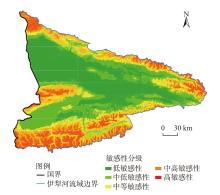
图5
伊犁河流域孕灾环境敏感性分布"
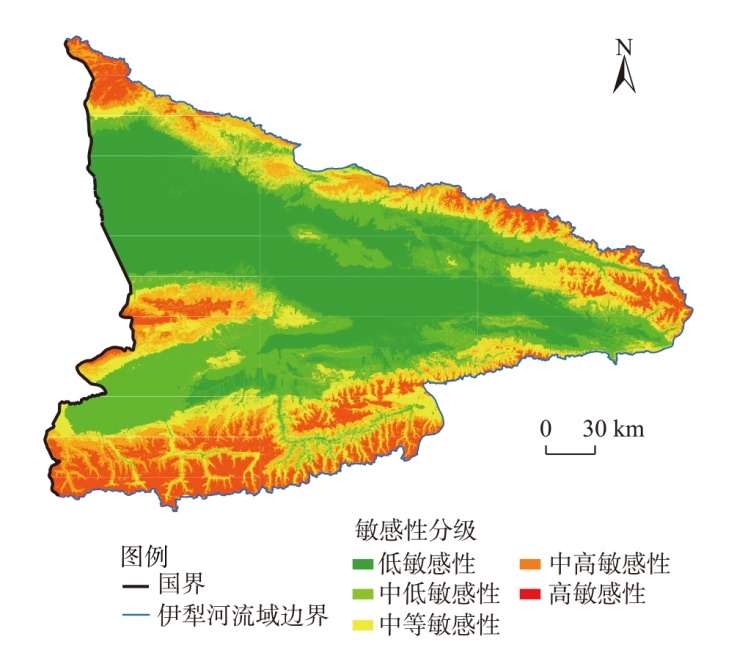
表5
孕灾环境敏感性分级"
| 敏感性分级 | 孕灾环境敏感性指数 | 面积/km2 | 占比/% |
|---|---|---|---|
| 低敏感性 | 1.29~2.04 | 17809.26 | 31.76 |
| 中低敏感性 | 2.05~2.69 | 13996.23 | 24.96 |
| 中等敏感性 | 2.70~3.25 | 9366.95 | 16.70 |
| 中高敏感性 | 3.26~3.84 | 7588.53 | 13.53 |
| 高敏感性 | 3.85~4.98 | 7320.46 | 13.05 |

图6
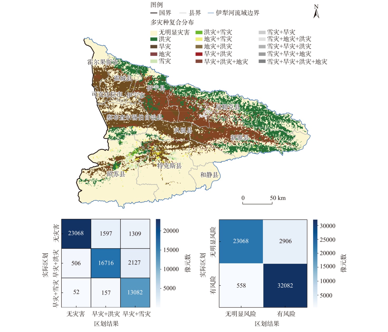
伊犁河流域灾害影响分布"
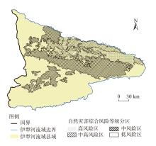
图7
伊犁河流域自然灾害综合风险等级分区"

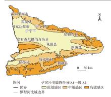
图8
伊犁河流域自然灾害风险区划一级区划"

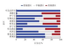
图9
各县区孕灾环境敏感性分区占比"

图10
伊犁河流域自然灾害综合风险区划二级区划"
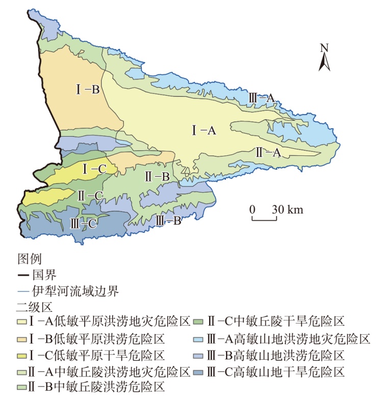
表6
伊犁河流域自然灾害综合风险二级区划编码表"
| 编码 | 区域名称 | 面积占比/% |
|---|---|---|
| Ⅰ-A | 低敏平原洪涝地灾危险区 | 22.32 |
| Ⅰ-B | 低敏平原洪涝危险区 | 14.41 |
| Ⅰ-C | 低敏平原干旱危险区 | 4.50 |
| Ⅱ-A | 中敏丘陵洪涝地灾危险区 | 14.65 |
| Ⅱ-B | 中敏丘陵洪涝危险区 | 12.23 |
| Ⅱ-C | 中敏丘陵干旱危险区 | 6.27 |
| Ⅲ-A | 高敏山地洪涝地灾危险区 | 9.54 |
| Ⅲ-B | 高敏山地洪涝危险区 | 8.93 |
| Ⅲ-C | 高敏山地干旱危险区 | 7.16 |
图11
伊犁河流域自然灾害综合风险区划"

表7
伊犁河流域自然灾害综合风险区划编码表"
| 编码 | 区域名称 | 编码 | 区域名称 |
|---|---|---|---|
| Ⅰ-A-a | 低敏平原洪涝地灾高风险区 | Ⅱ-A-d | 中敏丘陵洪涝地灾低风险区 |
| Ⅰ-A-b | 低敏平原洪涝地灾中高风险区 | Ⅱ-B-a | 中敏丘陵洪涝高中风险区 |
| Ⅰ-A-c | 低敏平原洪涝地灾中风险区 | Ⅱ-B-b | 中敏丘陵洪涝中高风险区 |
| Ⅰ-A-d | 低敏平原洪涝地灾低风险区 | Ⅱ-C-a | 中敏丘陵干旱高风险区 |
| Ⅰ-B-a | 低敏平原洪涝高风险区 | Ⅱ-C-c | 中敏丘陵干旱中风险区 |
| Ⅰ-B-b | 低敏平原洪涝中高风险区 | Ⅱ-A-a | 高敏山区洪涝地灾高风险区 |
| Ⅰ-B-c | 低敏平原洪涝中风险区 | Ⅲ-A-b | 高敏山区洪涝地灾中高风险区 |
| Ⅰ-B-d | 低敏平原洪涝低风险区 | Ⅲ-A-c | 高敏山区洪涝地灾中风险区 |
| Ⅰ-C-a | 低敏平原干旱高风险区 | Ⅲ-A-d | 高敏山区洪涝地灾低风险区 |
| Ⅰ-C-b | 低敏平原干旱中高风险区 | Ⅲ-B-a | 高敏山区洪涝高风险区 |
| Ⅱ-A-a | 中敏丘陵洪涝地灾高风险区 | Ⅲ-B-b | 高敏山区洪涝中高风险区 |
| Ⅱ-A-b | 中敏丘陵洪涝地灾中高风险区 | Ⅲ-C-a | 高敏山区干旱高风险区 |
| Ⅱ-A-c | 中敏丘陵洪涝地灾中风险区 | Ⅲ-C-b | 高敏山区干旱中高风险区 |

图12
区划结果检验"
| [1] | 史培军. 四论灾害系统研究的理论与实践[J]. 自然灾害学报, 2005, 14(6): 1-7. |
| [Shi Peijun. Theory and practice on disaster system research in a fourth time[J]. Journal of Natural Disasters, 2005, 14(6): 1-7.] | |
| [2] | IPCC (Intergovernmental Panel on Climate Change). Managing the risks of extreme events and disasters to advance climate change adaptation: A special report of working groups I and II of the intergovernmental panel on climate change[M]. Cambridge: Cambridge University Press, 2012: 1-582. |
| [3] | 国务院第一次全国自然灾害综合风险普查领导小组办公室. 自然灾害综合风险区划与综合防治区划[M]. 北京: 应急管理出版社, 2023: 1-105. |
| [ Office of the Leading Group for the First National Comprehensive Risk Survey of Natural Disasters of the State Council. Comprehensive risk zoning and comprehensive prevention and control zoning of natural disasters[M]. Beijing: Emergency Management Press, 2023: 1-105.] | |
| [4] | Dibash D, Mohammad M D, Abu S M, et al. Coastal vulnerability assessment to multi hazards in the exposed coast of southeastern coastal region of Bangladesh[J]. Regional Studies in Marine Science, 2024, 73: 103484, doi: 10.1016/j.rsma.2024.103484. |
| [5] | Sammonds P, Alam A, Day S, et al. Hurricane risk assessment in a multi-hazard context for Dominica in the Caribbean[J]. Scientific Reports, 2023, 13: 20565, doi: 10.1038/s41598-023-47527-5. |
| [6] | Taubenböck H, Wurm M, Netzband M, et al. Flood risks in urbanized areas: Multi-sensoral approaches using remotely sensed data for risk assessment[J]. Natural Hazards and Earth System Sciences, 2011, 11(2): 431-444. |
| [7] | 王平, 史培军. 自下而上进行区域自然灾害综合区划的方法研究——以湖南省为案例[J]. 自然灾害学报, 1999, 8(3): 54-60. |
| [Wang Ping, Shi Peijun. The reasearch of regional natural disaster regionalization with the “bottom-up” mathods: Case study of Hunan Povince[J]. Journal of Natural Disasters, 1999, 8(3): 54-60.] | |
| [8] | Gao C, Zhang B Y, Shao S B, et al. Risk assessment and zoning of flood disaster in Wuchengxiyu Region, China[J]. Urban Climate, 2023, 49: 101562, doi: 10.1016/j.uclim.2023.101562. |
| [9] | 孙蕊, 丁雨虹, 郭海燕, 等. 基于GIS的四川省降水诱发型滑坡泥石流风险区划[J]. 高原山地气象研究, 2022, 42(3): 111-116, 140. |
| [Sun Rui, Ding Yuhong, Guo Haiyan, et al. GIS-based zoning of rainfall-induced landslide and debris flow risk in Sichuan Province[J]. Plateau and Mountain Meteorology Research, 2022, 42(3): 111-116, 140.] | |
| [10] |
褚越, 薛晓萍, 张丽娟, 等. 山东省干旱灾害风险评估与区划[J]. 中国农学通报, 2023, 39(10): 101-112.
doi: 10.11924/j.issn.1000-6850.casb2022-0276 |
|
[Chu Yue, Xue Xiaoping, Zhang Lijuan, et al. Risk assessment and zoning of drought disasters in Shandong Province[J]. Chinese Agricultural Science Bulletin, 2023, 39(10): 101-112.]
doi: 10.11924/j.issn.1000-6850.casb2022-0276 |
|
| [11] | 哈斯, 张继权, 佟斯琴, 等. 灾害链研究进展与展望[J]. 灾害学, 2016, 31(2): 131-138. |
| [Ha Si, Zhang Jiquan, Tong Siqin, et al. Progress and prospect of the research on disaster chain[J]. Journal of Catastrophology, 2016, 31(2): 131-138.] | |
| [12] |
Helbing D. Globally networked risks and how to respond[J]. Nature, 2013, 497: 51-59.
doi: 10.1038/nature12047 |
| [13] |
Pourghasemi H R, Kariminejad N, Amiri M, et al. Assessing and mapping multi-hazard risk susceptibility using a machine learning technique[J]. Scientific Reports, 2020, 10: 3203, doi: 10.1038/s41598-020-60191-3.
pmid: 32081935 |
| [14] |
Yang W C, Dun X B, Jiang X L, et al. An integrated risk assessment framework for multiple natural disasters based on multi-dimensional correlation analysis[J]. Natural Hazards, 2023, 119(3): 1531-1550.
doi: 10.1007/s11069-023-06159-8 |
| [15] |
刘星才, 汤秋鸿, 尹圆圆, 等. 气候变化下中国未来综合环境风险区划研究[J]. 地理科学, 2018, 38(4): 636-644.
doi: 10.13249/j.cnki.sgs.2018.04.018 |
| [Liu Xingcai, Tang Qiuhong, Yin Yuanyuan, et al. Regionalization of integrated environmental risk of China under future climate change[J]. Geographical Science, 2018, 38(4): 636-644.] | |
| [16] |
吴绍洪, 刘燕华, 邓浩宇, 等. 中国综合气候变化风险区划[J]. 地理学报, 2017, 72(1): 3-17.
doi: 10.11821/dlxb201701001 |
|
[Wu Shaohong, Liu Yanhua, Deng Haoyu, et al. Comprehensive climate change risk regionalization of China[J]. Acta Geographica Sinica, 2017, 72(1): 3-17.]
doi: 10.11821/dlxb201701001 |
|
| [17] |
KC B, Shepherd J M, King A W, et al. Multi-hazard climate risk projections for the United States[J]. Natural Hazards, 2021, 105(2): 1963-1976.
doi: 10.1007/s11069-020-04385-y |
| [18] | 黄新平. 伊犁州直在丝绸之路经济带中的战略定位思考[J]. 中共伊犁州委党校学报, 2016(2): 42-46. |
| [Huang Xinping. Thoughts on the strategic positioning of Yili Prefecture in the Silk Road Economic Belt[J]. Journal of Yili Prefecture Communist Party, 2016(2): 42-46.] | |
| [19] | 殷剑虹, 徐予洋. 伊犁河谷气候变化特征分析[J]. 沙漠与绿洲气象, 2007, 1(6): 20-23. |
| [Yin Jianhong, Xu Yuyang. Analysis of climate change characteristics in Yili Valley[J]. Desert and Oasis Meteorology, 2007, 1(6): 20-23.] | |
| [20] | 张军民. 伊犁河流域地质构造及其地形地貌特点的研究[J]. 石河子大学学报(自然科学版), 2006, 24(4): 442-445. |
| [Zhang Junmin. Studies on the geological structures and characteristic of terrain and landform in Yili River Basin[J]. Journal of Shihezi University (Natural Science), 2006, 24(4): 442-445.] | |
| [21] | 国家青藏高原科学数据中心.中国1 km分辨率逐月降水量数据集(1901—2024)[DB/OL]. [2025-07-02]. https://www.tpdc.ac.cn/zh-hans/data/faae7605-a0f2-4d18-b28f-5cee413766a2. |
| [National Tibetan Plateau Data Center. 1 km monthly precipitation dataset for China (1901—2024)[DB/OL]. [2025-07-02]. https://www.tpdc.ac.cn/zh-hans/data/faae7605-a0f2-4d18-b28f-5cee413766a2. ] | |
| [22] | 国家青藏高原科学数据中心.中国1 km分辨率逐月平均气温数据集(1901—2024)[DB/OL]. [2025-07-02]. https://www.tpdc.ac.cn/zh-hans/data/71ab4677-b66c-4fd1-a004-b2a541c4d5bf/. |
| [National Tibetan Plateau Data Center. 1 km monthly mean temperature dataset for China (1901—2024)[DB/OL]. [2025-07-02]. https://www.tpdc.ac.cn/zh-hans/data/71ab4677-b66c-4fd1-a004-b2a541c4d5bf/. ] | |
| [23] |
Yang J, Huang X. The 30 m annual land cover dataset and its dynamics in China from 1990 to 2019[J]. Earth System Science Data, 2021, 13(8): 3907-3925.
doi: 10.5194/essd-13-3907-2021 |
| [24] | 国家冰川冻土沙漠科学数据中心. 基于世界土壤数据库(HWSD)的中国土壤数据集(v1.1)(2009)[DB/OL]. [2020-03-26]. https://www.tpdc.ac.cn/zh-hans/data/611f7d50-b419-4d14-b4dd-4a944b141175/. |
| [National Tibetan Plateau Data Center.China soil map based harmonized world soil database(HWSD) (v1.1) (2009)[DB/OL]. [2020-03-26]. https://www.tpdc.ac.cn/zh-hans/data/611f7d50-b419-4d14-b4dd-4a944b141175/. ] | |
| [25] | 张鹏, 张云霞, 孙舟, 等. 综合灾情指数——一种自然灾害损失的定量化评价方法[J]. 灾害学, 2015, 30(4): 74-78. |
| [Zhang Peng, Zhang Yunxia, Sun Zhou, et al. Natural disaster index: A quantitative measure for assessing natural disaster losses[J]. Journal of Catastrophology, 2015, 30(4): 74-78.] | |
| [26] |
Saaty T L. A scaling method for priorities in hierarchical structures[J]. Journal of Mathematical Psychology, 1977, 15(3): 234-281.
doi: 10.1016/0022-2496(77)90033-5 |
| [27] |
Frazier T G, Thompson C M, Dezzani R J, et al. Spatial and temporal quantification of resilience at the community scale[J]. Applied Geography, 2013, 42: 95-107.
doi: 10.1016/j.apgeog.2013.05.004 |
| [28] | 隋刚, 郝兵元, 彭林. 利用高程标准差表达地形起伏程度的数据分析[J]. 太原理工大学学报, 2010, 41(4): 381-384, 401. |
| [Sui Gang, Hao Bingyuan, Peng Lin. Data analysis of elevation standard deviation classifying relief degree of land surface[J]. Journal of Taiyuan University of Technology, 2010, 41(4): 381-384, 401.] | |
| [29] | 王智, 吴友均, 梁凤超, 等. 新疆地区年降水量的空间插值方法研究[J]. 中国农业气象, 2011, 32(3): 331-337. |
| [Wang Zhi, Wu Youjun, Liang Fengchao, et al. Study on spatial interpolation method of annual precipitation in Xinjiang[J]. Chinese Journal of Agrometeorology, 2011, 32(3): 331-337.] | |
| [30] |
赵美龄, 许晓露, 陈辰, 等. 土地利用/覆被变化对地质灾害发育的影响研究[J]. 遥感技术与应用, 2022, 37(2): 399-407.
doi: 10.11873/j.issn.1004-0323.2022.2.0399 |
| [Zhao Meiling, Xu Xiaolu, Chen Chen, et al. Research on the impact of land use/cover change on geological disaster development[J]. Remote Sensing Technology and Application, 2022, 37(2): 399-407.] | |
| [31] | 王秀荣, 吕终亮, 王莉萍, 等. 一种简化的暴雨灾害风险及影响评估方法和应用研究——以京津冀“7·21”暴雨事件为例[J]. 气象, 2016, 42(2): 213-220. |
| [Wang Xiurong, Lü Zhongliang, Wang Liping, et al. Simplified assessment method and application research of rainstorm disaster risk and impact: Using Jing-Jin-Ji “7·21” heavy rain as an example[J]. Meteorological Monthly, 2016, 42(2): 213-220.] | |
| [32] | 邓运超, 刘旭艳, 毕玮, 等. 基于GIS的莱西市洪涝灾害风险区划[J]. 科技通报, 2020, 36(7): 21-28. |
| [Deng Yunchao, Liu Xuyan, Bi Wei, et al. The risk zoning of flood disaster in Laixi based on GIS[J]. Bulletin of Science and Technology, 2020, 36(7): 21-28.] | |
| [33] | 史培军. 中国自然灾害系统地图集[M]. 北京: 科学出版社, 2003: 1-218. |
| [Shi Peijun. Atlas of natural disaster systems of China[M]. Beijing: Science Press, 2003: 1-218.] | |
| [34] | 自治区第一次全国自然灾害综合风险普查领导小组办公室. 自治区第一次全国自然灾害综合风险普查公报汇编[R]. 乌鲁木齐: 自治区第一次全国自然灾害综合风险普查领导小组办公室, 2024. |
| [Office of the Leading Group for the First National Natural Disaster Risk Census of the Autonomous Region. Compilation of the bulletin of the first national natural disaster risk census in the Autonomous Region[R]. Urumqi: Office of the Leading Group for the First National Natural Disaster Risk Census of the Autonomous Region, 2024.] | |
| [35] |
古丽扎尔·莫明, 杨莲梅, 刘艳, 等. 伊犁河流域近30 a洪水灾害时空分布及孕灾环境特征研究[J]. 干旱区地理, 2024, 47(8): 1314-1326.
doi: 10.12118/j.issn.1000-6060.2023.404 |
|
[Moming Gulzar, Yang Lianmei, Liu Yan, et al. Spatial and temporal distribution of flood disasters and characteristics of disaster-prone environment in Ili River Basin in recent 30 years[J]. Arid Land Geography, 2024, 47(8): 1314-1326.]
doi: 10.12118/j.issn.1000-6060.2023.404 |
| [1] | 刘京会, 袁旭山, 李艳敏, 李鑫旭. 基于CMIP6的伊犁河流域极端降水时空特征分析研究[J]. 干旱区地理, 2025, 48(8): 1329-1341. |
| [2] | 余瀚, 孟志华, 王静爱. 甘肃省自然灾害社会脆弱性评价与综合区划[J]. 干旱区地理, 2025, 48(8): 1421-1431. |
| [3] | 陈世泷, 孟庆凯, 戴勇, 杨立强, 吴晗. 基于CMIP6未来情景的伊犁河流域地质灾害危险性评估预测[J]. 干旱区地理, 2025, 48(4): 599-611. |
| [4] | 古丽扎尔·莫明, 杨莲梅, 刘艳, 李新国. 伊犁河流域近30 a洪水灾害时空分布及孕灾环境特征研究[J]. 干旱区地理, 2024, 47(8): 1314-1326. |
| [5] | 李雅倩, 杨建华, 夏皓斌, 武建军. 2000—2022年伊犁河流域植被时空变化特征[J]. 干旱区地理, 2024, 47(5): 741-752. |
| [6] | 张仲福. 黄河流域甘肃段地质遗迹空间区划及可持续开发利用策略[J]. 干旱区地理, 2022, 45(4): 1235-1243. |
| [7] | 顾玮,古丽·加帕尔,尹瀚民,姜亮亮,藏晓芳. 新疆南疆地区太阳能资源时空分布特征及区划研究[J]. 干旱区地理, 2021, 44(6): 1665-1675. |
| [8] | 崔洋, 常倬林, 左河疆, 王建英. 贺兰山银川段不同重现期山洪灾害风险与影响区划研究[J]. 干旱区地理, 2020, 43(4): 859-870. |
| [9] | 徐玉霞, 许小明, 方锋, 贺锐. 县域尺度下的宝鸡市农业洪水灾害脆弱性评价及区划 [J]. 干旱区地理, 2020, 43(3): 652-660. |
| [10] | 王勇, 赵战成, 晏军, 唐冶, 蔡芸瞳. 新疆雪灾的时空分布特征及其等级划分[J]. 干旱区地理, 2020, 43(3): 577-583. |
| [11] | 刘洁, 黄金川, 林浩曦. 冰冻圈水资源服务功能区划研究综述[J]. 干旱区地理, 2018, 41(4): 751-760. |
| [12] | 徐玉霞, 许小明, 马楠. 县域尺度下的陕西省洪涝灾害风险评估及区划[J]. 干旱区地理, 2018, 41(2): 306-313. |
| [13] | 杨萍, 李陇堂, 苏丙杰, 夏四友, 高秀云, 石磊. 沙漠旅游主体功能区划实证研究——以腾格里沙漠东南缘沙漠旅游集聚区为例[J]. 干旱区地理, 2018, 41(1): 178-184. |
| [14] | 邓铭江, 樊自立, 徐海量, 周海鹰. 塔里木河流域生态功能区划研究[J]. 干旱区地理, 2017, 40(4): 705-717. |
| [15] | 杨振, 雷军, 英成龙, 段祖亮. 新疆县域城镇化的综合测度及空间分异格局分析[J]. 干旱区地理, 2017, 40(1): 230-237. |
|
||