| [1] |
雷波, 焦峰, 王志杰, 等. 黄土丘陵区不同植被带典型小流域生态脆弱性评价[J]. 自然灾害学报, 2013, 22(5): 149-159.
|
|
[ Lei Bo, Jiao Feng, Wang Zhijie, et al. Eco-environment vulnerability assessment of typical small watersheds in different vegetation zones of loess hilly area[J]. Journal of Natural Disasters, 2013, 22(5): 149-159. ]
|
| [2] |
魏晓旭, 赵军, 魏伟, 等. 中国县域单元生态脆弱性时空变化研究[J]. 环境科学学报, 2016, 36(2): 726-739.
|
|
[ Wei Xiaoxu, Zhaojun, et al. Spatial and temporal changes of ecological vulnerability per county unit in China[J]. Acta Scientiae Circumstantiae, 2016, 36(2): 726-739. ]
|
| [3] |
赵桂久, 刘燕华, 赵名茶. 生态环境综合整治与恢复技术研究[M]. 北京: 科学技术出版社, 1995: 47-80.
|
|
[ Zhao Guijiu, Liu Yanhua, Zhao Mingcha. Study on the technology of comprehensive regulation and restoration of ecological environment[M]. Beijing: Science and Technology Press, 1995: 47-80. ]
|
| [4] |
贾晶晶, 赵军, 王建邦, 等. 基于SRP模型的石羊河流域生态脆弱性评价[J]. 干旱区资源与环境, 2020, 34(1): 34-41.
|
|
[ Jia Jingjing, Zhao Jun, Wang Jianbang, et al. Ecological vulnerability assessment of Shiyang River Basin based on SRP model[J]. Journal of Arid Land Resources and Environment, 2020, 34(1): 34-41. ]
|
| [5] |
安芬, 李旭东, 程东亚. 贵州省乌江流域生态脆弱性评价及其空间变化特征[J]. 水土保持通报, 2019, 39(4): 261-269.
|
|
[ An Fen, Li Xudong, Cheng Dongya. Ecological vulnerability assessment and spatial variation characteristics of Wujiang River Basin in Guizhou Province[J]. Bulletin of Soil and Water Conservation, 2019, 39(4): 261-269. ]
|
| [6] |
霍童, 张序, 周云, 等. 基于暴露-敏感-适应性模型的生态脆弱性时空变化评价及相关分析——以中国大运河苏州段为例[J]. 生态学报, 2022, 42(6): 2281-2293.
|
|
[ Huo Tong, Zhang Xu, Zhou Yun, et al. Identification of the critical ecological spaces in the Dongjiang River Basin based on ecosystem service function[J]. Acta Ecologica Sinica, 2022, 42(6): 2281-2293. ]
|
| [7] |
杨雯娜, 周亮, 孙东琪. 基于分区-集成的黄河流域生态脆弱性评价[J]. 自然资源遥感, 2021, 33(3): 211-218.
|
|
[ Yang Wenna, Zhou Liang, Sun Dongqi. Ecological vulnerability assessment of the Yellow River Basin based on partition-integration concept[J]. Remote Sensing for Natural Resources, 2021, 33(3): 211-218. ]
|
| [8] |
乌宁巴特, 刘新平, 马相平. 叶尔羌河流域土地生态脆弱性差异评价[J]. 干旱区地理, 2020, 43(3): 849-858.
|
|
[ Wu Ningbart, Liu Xinping, Ma Xiangping. Evaluation on the difference of land ecological vulnerability in the Yarkant River Basin[J]. Arid Land Geography, 2020, 43(3): 849-858. ]
|
| [9] |
马子惠, 马书明, 张树深. 大连市生态脆弱性评价及其不确定性分析[J]. 水土保持通报, 2019, 39(3): 237-242, 262, 313-314.
|
|
[ Ma Zihui, Ma Shuming, Zhang Shushen. Ecological vulnerability assessment and its uncertainty analysis of Dalian City[J]. Bulletin of Soil and Water Conservation, 2019, 39(3): 237-242, 262, 313-314. ]
|
| [10] |
王鹏, 赵微, 柯新利. 基于SRP模型的潜江市生态脆弱性评价及时空演变[J]. 水土保持研究, 2021, 28(5): 347-354.
|
|
[ Wang Peng, Zhao Wei, Ke Xinli. Evaluation and spatiotemporal evolution of ecological vulnerability of Qianjiang based on SRP model[J]. Research of Soil and Water Conservation, 2021, 28(5): 347-354. ]
|
| [11] |
钟祺康, 王志一, 王娜, 等. 陕北干旱区景观生态风险空间分异特征及驱动因素分析[J]. 测绘通报, 2022, 544(7): 100-106.
|
|
[ Zhong Qikang, Wang Zhiyi, Wang Na, et al. Spatial differentiation characteristics and driving factors of landscape ecological risk in arid area of northern Shaanxi[J]. Bulletin of Surveying and Mapping, 2022, 544(7): 100-106. ]
|
| [12] |
张佳辰, 高鹏, 董学德, 等. 基于景观格局分析的青岛市海岸带生态脆弱性评价[J]. 生态与农村环境学报, 2021, 37(8): 1022-1030.
|
|
[ Zhang Jiachen, Gao Peng, Dong Xuede, et al. Ecological vulnerability assessment of Qingdao coastal zone based on landscape pattern analysis[J]. Journal of Ecology and Rural Environment, 2021, 37(8): 1022-1030. ]
|
| [13] |
李路, 孙桂丽, 陆海燕, 等. 喀什地区生态脆弱性时空变化及驱动力分析[J]. 干旱区地理, 2021, 44(1): 277-288.
|
|
[ Li Lu, Sun Guili, Lu Haiyan, et al. Spatial-temporal variation and driving forces of ecological vulnerability in Kashi Prefecture[J]. Arid Land Geography, 2021, 44(1): 277-288. ]
|
| [14] |
徐超璇, 鲁春霞, 黄绍琳. 张家口地区生态脆弱性及其影响因素[J]. 自然资源学报, 2020, 35(6): 1288-1300.
doi: 10.31497/zrzyxb.20200603
|
|
[ Xu Chaoxuan, Lu Chunxia, Huang Shaolin. Study on ecological vulnerability and its influencing factors in Zhangjiakou area[J]. Journal of Natural Resources, 2020, 35(6): 1288-1300. ]
doi: 10.31497/zrzyxb.20200603
|
| [15] |
张行, 陈海, 史琴琴, 等. 陕西省景观生态脆弱性时空演变及其影响因素[J]. 干旱区研究, 2020, 37(2): 496-505.
|
|
[ Zhang Xing, Chen Hai, Shi Qinqin, et al. Spatiotemporal evolution and driving factors of landscape ecological vulnerability in Shaanxi Province[J]. Arid Zone Research, 2020, 37(2): 496-505. ]
|
| [16] |
孙桂丽, 陆海燕, 郑佳翔, 等. 新疆生态脆弱性时空演变及驱动力分析[J]. 干旱区研究, 2022, 39(1): 258-269.
|
|
[ Sun Guili, Lu Haiyan, Zheng Jiaxiang, et al. Spatio-temporal variation of ecological vulnerability in Xinjiang and driving force analysis[J]. Arid Zone Research, 2022, 39(1): 258-269. ]
|
| [17] |
朱琪, 周旺明, 贾翔, 等. 长白山国家自然保护区及其周边地区生态脆弱性评估[J]. 应用生态学报, 2019, 30(5): 1633-1641.
doi: 10.13287/j.1001-9332.201905.030
|
|
[ Zhu Qi, Zhou Wangming, Jiaxiang, et al. Ecological vulnerability assessment on Changbai Mountain National Nature Reserve and its surrounding areas, northeast China[J]. Chinese Journal of Applied Ecology, 2019, 30(5): 1633-1641. ]
doi: 10.13287/j.1001-9332.201905.030
|
| [18] |
朱琪, 王亚楠, 周旺明, 等. 东北森林带生态脆弱性时空变化及其驱动因素[J]. 生态学杂志, 2021, 40(11): 3474-3482.
|
|
[ Zhu Qi, Wang Ya’nan, Zhou Wangming, et al. Spatiotemporal changes and driving factors of ecological vulnerability in northeast China forest belt[J]. Chinese Journal of Ecology, 2021, 40(11): 3474-3482. ]
|
| [19] |
刘佳茹, 赵军, 沈思民, 等. 基于SRP概念模型的祁连山地区生态脆弱性评价[J]. 干旱区地理, 2020, 43(6): 1573-1582.
|
|
[ Liu Jiaru, Zhao Jun, Shen Simin, et al. Ecological vulnerability assessment of Qilian Mountains region based on SRP conceptual model[J]. Arid Land Geography, 2020, 43(6): 1573-1582. ]
|
| [20] |
李芮芝, 胡希军, 杜心宇, 等. 基于SRP模型的南雄丹霞梧桐自然保护区生态脆弱性评价[J]. 西北林学院学报, 2021, 36(5): 152-160.
|
|
[ Li Ruizhi, Hu Xijun, Du Xinyu, et al. Ecological vulnerability assessment based on SPR model in Nanxiong Danxia Indus Nature Reservation Area[J]. Journal of Northwest Forestry University, 2021, 36(5): 152-160. ]
|
| [21] |
王茜, 赵筱青, 普军伟, 等. 滇东南喀斯特区域生态脆弱性的时空演变及其影响因素[J]. 应用生态学报, 2021, 32(6): 2180-2190.
doi: 10.13287/j.1001-9332.202106.018
|
|
[ Wang Qian, Zhao Xiaoqing, Pu Junwei, et al. Spatial-temporal variations and influencing factors of eco-environment vulnerability in the karst region of southeast Yunnan, China[J]. Chinese Journal of Applied Ecology, 2021, 32(6): 2180-2190. ]
doi: 10.13287/j.1001-9332.202106.018
|
| [22] |
陈臻琦, 张靖, 张贻龙, 等. 基于VSD的近20 a来浑善达克沙地生态脆弱性变化研究[J]. 干旱区研究, 2021, 38(5): 1464-1473.
|
|
[ Chen Zhenqi, Zhang Jing, Zhang Yilong, et al. Spatio-temporal patterns variation of ecological vulnerability in Otindag Sandy Land based on a vulnerability scoping diagram[J]. Arid Zone Research, 2021, 38(5): 1464-1473. ]
|
| [23] |
陈枫, 李泽红, 董锁成, 等. 基于VSD模型的黄土高原丘陵沟壑区县域生态脆弱性评价——以甘肃省临洮县为例[J]. 干旱区资源与环境, 2018, 32(11): 74-80.
|
|
[ Chen Feng, Li Zehong, Dong Suocheng, et al. Evaluation of ecological vulnerability in gully-hilly region of Loess Plateau based on VSD model: A case of Lintao County[J]. Journal of Arid Land Resources and Environment, 2018, 32(11): 74-80. ]
|
| [24] |
张学渊, 魏伟, 周亮, 等. 西北干旱区生态脆弱性时空演变分析[J]. 生态学报, 2021, 41(12): 4707-4719.
|
|
[ Zhang Xueyuan, Zhou Liang, et al. Analysis on spatio-temporal evolution of ecological vulnerability in arid areas of northwest China[J]. Acta Ecologica Sinica, 2021, 41(12): 4707-4719. ]
|
| [25] |
黄越, 程静, 王鹏. 中国北方农牧交错区生态脆弱性时空演变格局与驱动因素——以盐池县为例[J]. 干旱区地理, 2021, 44(4): 1175-1185.
|
|
[ Huang Yue, Cheng Jing, Wang Peng. Spatiotemporal evolution pattern and driving factors of ecological vulnerability in agro-pastoral region in northern China: A case of Yanchi County in Ningxia[J]. Arid Land Geography, 2021, 44(4): 1175-1185. ]
|
| [26] |
郭婧, 魏珍, 任君, 等. 基于熵权灰色关联法的高寒贫困山区生态脆弱性分析——以青海省海东市为例[J]. 水土保持通报, 2019, 39(3): 191-199.
|
|
[ Guo Jing, Wei Zhen, Ren Jun, et al. Analysis on ecological vulnerability in high-cold and poverty-stricken mountainous areas based on entropy and gray correlation methods: A case study in Haidong City, Qinghai Province[J]. Bulletin of Soil and Water Conservation, 2019, 39(3): 191-199. ]
|
| [27] |
卓静, 朱延年, 何慧娟, 等. 生态恢复工程对陕北地区生态系统格局的影响[J]. 生态学报, 2020, 40(23): 8627-8637.
|
|
[ Zhuo Jing, Zhu Yannian, He Huijuan, et al. Impacts of ecological restoration projects on the ecosystem in the Loess Plateau[J]. Acta Ecologica Sinica, 2020, 40(23): 8627-8637. ]
|
| [28] |
傅伯杰. 退耕还林工程是黄土实现了生态环境保护和社会经济发展“双赢”[N]. 延安日报, 2019-08-13(04).
|
|
[ Fu Bojie. The project of returning farmland to forest has realized the “win-win” of ecological environment protection and social and economic development of loess[N]. Yanan Daily, 2019-08-13(04). ]
|
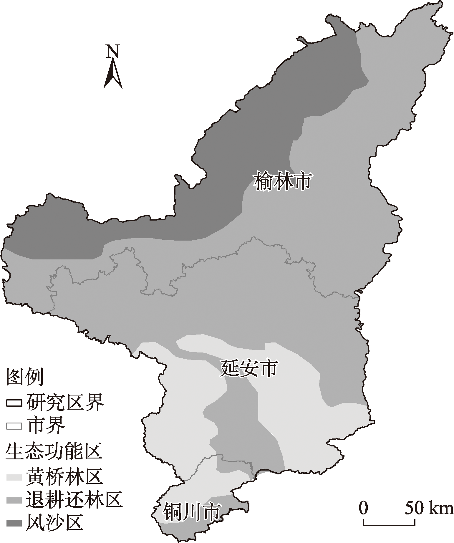
 ),胡皓1,何慧娟3,王智1,杨承睿1