- 2025年5月14日 星期三
干旱区地理 ›› 2023, Vol. 46 ›› Issue (9): 1545-1555.doi: 10.12118/j.issn.1000-6060.2022.587 cstr: 32274.14.ALG2022587
马振邦1( ),王思鉴1,李薇1,吕鹏2,郭晓东1
收稿日期:2022-11-09
修回日期:2023-02-06
出版日期:2023-09-25
发布日期:2023-09-28
作者简介:马振邦(1983-),男,博士,副教授,主要从事贫困治理与乡村可持续发展研究. E-mail: 基金资助:
MA Zhenbang1(),WANG Sijian1,LI Wei1,LYU Peng2,GUO Xiaodong1
Received:2022-11-09
Revised:2023-02-06
Published:2023-09-25
Online:2023-09-28
摘要:
明晰长时间尺度上贫困时空动态特征和驱动因素,能为接续推进相对贫困治理和乡村全面振兴提供有益借鉴。基于1986—2020年经济社会面板数据,以农民人均纯收入为表征,考察甘肃省六盘山片区近35 a贫困的时空演变,运用动态空间面板模型解析驱动因素的长短期效应和空间溢出效应差异。结果表明:(1) 甘肃省六盘山片区大部分县区农民人均纯收入增速有提高趋势,这一趋势未来仍会持续。(2) 28个县区收入增速在1994年或2007年存在结构性突变点,这与“八七扶贫攻坚计划”、农村税费改革和城乡基本公共服务均等化、快速城镇化等宏观因素有关。(3) 时间上低收入县区很难跨入高收入县区,空间上热点和冷点区域分布相对稳定,农民人均纯收入存在显著的时空依赖,但程度因空间溢出效应而减轻。(4) 长期和短期来看,经济增长、产业结构和城镇化对本地和相邻县区农民人均纯收入有显著影响,是空间溢出效应的主要来源;仅短期来说,人力资本、种植结构、交通设施对本地和更大空间范围上农民人均纯收入具有显著影响;降雨量具有长期正向影响,意味着西北地区暖湿化趋势是一个重要利好。鉴于时空上贫困的强稳定性和驱动因素作用的差异性,原连片特困地区相对贫困治理需要系统考虑政策措施的时空协调性。
马振邦,王思鉴,李薇,吕鹏,郭晓东. 1986—2020年甘肃省六盘山片区贫困演变及启示[J]. 干旱区地理, 2023, 46(9): 1545-1555.
MA Zhenbang,WANG Sijian,LI Wei,LYU Peng,GUO Xiaodong. Poverty evolution and its implications in the Liupan Mountain Area of Gansu Province from 1986 to 2020[J]. Arid Land Geography, 2023, 46(9): 1545-1555.
表1
模型变量描述"
| 变量 | 符号 | 指标描述及含义 | 样本量 | 均值 | 标准差 | 来源 |
|---|---|---|---|---|---|---|
| 贫困程度 | income | 农民人均纯收入(1986年不变价)对数/元 | 1610 | 6.12 | 0.62 | 《甘肃发展年鉴》《甘肃农村年鉴》 |
| 经济水平 | perGDP | 人均GDP对数/104元·人-1 | 1610 | 7.35 | 1.20 | 《甘肃发展年鉴》 |
| 城镇化水平 | impervious | 人均不透水地表面积的对数/m2·人-1 | 1610 | 2.67 | 1.34 | Gong等[ |
| 产业结构 | GDP_1st | GDP中第一产业占比/% | 1610 | 0.35 | 0.19 | 《甘肃发展年鉴》 |
| 种植结构 | cashcrop | 农作物播种面积中经济作物占比/% | 1610 | 0.25 | 0.10 | 《甘肃发展年鉴》《甘肃农村年鉴》 |
| 农业机械化 | machine | 单位耕地农业机械总动力的对数/kW·hm-2 | 1610 | 0.94 | 1.01 | 《甘肃发展年鉴》《甘肃农村年鉴》 |
| 农业技术进步 | fertilizer | 单位耕地化肥施用折纯量的对数/kg·hm-2 | 1610 | 4.82 | 0.69 | 《甘肃发展年鉴》《甘肃农村年鉴》 |
| 财政支持力度 | fiscal_ER | 财政支出与财政收入之比的对数 | 1610 | 1.69 | 0.91 | 《甘肃发展年鉴》《甘肃农村年鉴》 |
| 年降水量 | rainfall | 年降水量的对数/mm | 1610 | 6.18 | 0.27 | 彭守璋[ |
| 灌溉设施 | irrigation | 有效灌溉面积占耕地比例/% | 1610 | 0.21 | 0.19 | 《甘肃农村年鉴》 |
| 高等级交通 | rail&highway | 是否通铁路或高速公路 | 1610 | 0.42 | 0.49 | 《甘肃路谱》,中国科学院资源环境科学与数据中心,1:25000全国基础地理数据库 |
| 公路密度 | road_den | 单位面积国省县道里程的对数/km·km-2 | 1610 | -0.78 | 0.56 | 《甘肃路谱》,中国科学院资源环境科学与数据中心,1:250000全国基础地理数据库 |
| 家庭规模 | household | 户均人口数量的对数/人 | 1610 | 1.45 | 0.16 | 《甘肃发展年鉴》《甘肃农村年鉴》 |
| 教育水平 | edu_year | 人均受教育年限的对数/a | 1610 | 1.80 | 0.35 | 人口普查数据(三普到七普),人口抽样调查数据(1987、1996、2005年和2015年) |
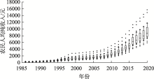
图1
1986—2020年研究区各县区农民人均纯收入箱式图"

表2
农民人均纯收入年均增速的统计特征"
| 县区 | 年均增速/% | Theil-Sen指数 | Hurst指数 |
|---|---|---|---|
| 全部46个县区 | 6.04 (4.91~7.42) | 0.22 (0.07~0.40) | 0.64 (0.55~0.75) |
| 榆中县,临夏县,麦积区,庄浪县,临洮县,静宁县,广河县,和政县,东乡县,皋兰县, 永登县 | 5.64 (4.91~6.12) | 0.30*** (0.24~0.40) | 0.64 (0.54~0.73) |
| 镇原县,崇信县,安定区,灵台县,秦州区,秦安县,宁县,泾川县,康乐县,会宁县, 景泰县,临夏市 | 5.97 (5.44~6.45) | 0.22** (0.18~0.25) | 0.64 (0.56~0.73) |
| 平川区,武山县,甘谷县,古浪县,合水县,环县,庆城县,靖远县,永靖县 | 6.26 (5.50~7.12) | 0.21* (0.16~0.29) | 0.63 (0.58~0.72) |
| 积石山县,通渭县,陇西县,渭源县,张家川回族自治县,漳县,清水县,华池县,华亭市,正宁县,西峰区,白银区,崆峒区,岷县 | 6.26 (5.65~7.42) | 0.16 (0.07~0.24) | 0.64 (0.56~0.75) |
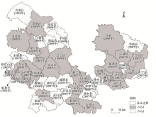
图2
1986—2020年农民人均纯收入增速的突变点"

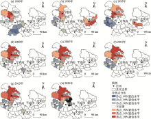
图3
1986—2020年农民人均纯收入的冷热点分布"

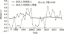
图4
1986—2020年农民人均纯收入及增速的空间自相关"

表3
1986—2020年不同农民人均纯收入类型的马尔科夫和空间马尔科夫转移矩阵"
| 矩阵 | 人均纯收入水平 | 人均纯收入水平 | ||||
|---|---|---|---|---|---|---|
| 高 | 中高 | 中低 | 低 | |||
| 马尔科夫矩阵 | 高 | 90.2 | 8.6 | 0.7 | 0.5 | |
| 中高 | 9.9 | 78.7 | 10.7 | 0.8 | ||
| 中低 | 0.8 | 10.7 | 77.1 | 11.4 | ||
| 低 | 0.0 | 1.2 | 10.5 | 88.4 | ||
| 空间马尔科夫 矩阵 | 高 | 高 | 90.9 | 8.7 | 0.4 | 0.0 |
| 中高 | 15.7 | 80.0 | 4.4 | 0.0 | ||
| 中低 | 0.0 | 19.4 | 71.0 | 9.7 | ||
| 低 | 0.0 | 0.0 | 25.0 | 75.0 | ||
| 中高 | 高 | 91.2 | 8.8 | 0.0 | 0.0 | |
| 中高 | 9.6 | 85.2 | 5.2 | 0.0 | ||
| 中低 | 1.9 | 14.8 | 74.1 | 9.3 | ||
| 低 | 0.0 | 0.0 | 12.8 | 87.2 | ||
| 中低 | 高 | 50.0 | 33.3 | 16.7 | 0.0 | |
| 中高 | 1.5 | 81.8 | 16.7 | 0.0 | ||
| 中低 | 0.0 | 9.5 | 81.0 | 9.5 | ||
| 低 | 0.0 | 1.0 | 12.4 | 86.7 | ||
| 低 | 高 | 100.0 | 0.0 | 0.0 | 0.0 | |
| 中高 | 0.0 | 78.1 | 18.8 | 3.1 | ||
| 中低 | 0.0 | 4.6 | 87.0 | 8.3 | ||
| 低 | 0.0 | 0.0 | 5.9 | 94.1 | ||
表4
面板模型估计结果"
| 模型变量 | pols | xtreg | xtabond2 | queen | que_lag | iver | iver2 | knn5 | |
|---|---|---|---|---|---|---|---|---|---|
| 模型(1) | 模型(2) | 模型(3) | 模型(4) | 模型(5) | 模型(6) | 模型(7) | 模型(8) | ||
| 自变量 | L_income | - | - | 0.879*** | - | 0.574*** | 0.594*** | 0.584*** | 0.586*** |
| S_income | - | - | - | 0.462*** | 0.343*** | 0.612*** | 0.441*** | 0.324*** | |
| perGDP | 0.425*** | 0.387*** | 0.066** | 0.065*** | 0.047*** | 0.054*** | 0.045*** | 0.044*** | |
| impervious | 0.007 | 0.134*** | 0.000 | 0.014*** | 0.006 | 0.008 | 0.006 | 0.005 | |
| GDP_1st | 0.775*** | 0.497*** | 0.129* | 0.154*** | 0.107*** | 0.147*** | 0.098*** | 0.096** | |
| cashcrop | 0.316*** | 0.204* | 0.038 | 0.013 | -0.022 | -0.013 | -0.026 | -0.016 | |
| machine | 0.093*** | 0.120** | -0.021 | 0.009 | 0.002 | -0.001 | 0.000 | 0.000 | |
| fertilizer | -0.015 | -0.051*** | -0.002 | 0.002 | -0.003 | -0.004 | 0.000 | -0.004 | |
| fiscal_ER | 0.070*** | 0.058*** | 0.021*** | -0.005 | -0.002 | -0.005 | -0.006 | -0.005 | |
| rainfall | 0.093*** | -0.014 | 0.009 | 0.099** | 0.062 | 0.018 | 0.058 | 0.055 | |
| irrigation | -0.103* | 0.331*** | 0.066 | 0.139*** | 0.047 | 0.029 | 0.095*** | 0.094*** | |
| rail&highway | 0.067*** | 0.010*** | 0.007 | 0.007 | -0.001 | 0.005 | -0.003 | -0.002 | |
| road_den | 0.115*** | 0.061 | 0.018* | 0.004 | 0.002 | 0.003 | -0.004 | 0.000 | |
| household | 0.379*** | 0.344*** | 0.083 | -0.003 | 0.010 | 0.030 | 0.009 | 0.010 | |
| edu_year | 0.329*** | 0.088 | 0.150*** | 0.002 | 0.013 | 0.005 | 0.010 | 0.009 | |
| _cons | 0.854*** | 2.089*** | -0.218 | - | - | - | - | - | |
| 空间滞后自变量 | perGDP | - | - | - | 0.054*** | 0.013 | 0.324*** | 0.007 | 0.001 |
| impervious | - | - | - | 0.045*** | 0.022** | 0.105* | 0.050*** | -0.009 | |
| GDP_1st | - | - | - | 0.160*** | 0.075** | 0.160*** | 0.195*** | 0.123*** | |
| cashcrop | - | - | - | -0.032 | 0.016 | 0.152*** | 0.105 | 0.040 | |
| machine | - | - | - | -0.016* | -0.009 | 0.049 | -0.008 | 0.012 | |
| fertilizer | - | - | - | 0.023* | -0.016 | -0.035 | -0.009 | -0.013 | |
| fiscal_ER | - | - | - | 0.004 | -0.008 | -0.013 | -0.018 | -0.013 | |
| rainfall | - | - | - | -0.148*** | -0.050 | -0.082 | -0.062 | -0.045 | |
| irrigation | - | - | - | 0.041 | -0.026 | 0.191 | -0.118* | -0.047 | |
| rail&highway | - | - | - | -0.015 | -0.015 | 0.0131*** | -0.013 | -0.013 | |
| road_den | - | - | - | -0.073*** | -0.012 | 0.047*** | 0.058* | 0.008 | |
| household | - | - | - | 0.096 | 0.066 | 0.185*** | 0.191** | 0.091 | |
| edu_year | - | - | - | 0.091*** | 0.030 | 0.278** | 0.033 | 0.036 | |
| N | 1610 | 1610 | 1564 | 1610 | 1564 | 1564 | 1564 | 1564 | |
| R2 | 0.913 | 0.934 | - | 0.771 | 0.971 | 0.887 | 0.969 | 0.979 | |
| AIC | -874.842 | -1522.114 | - | -3991.086 | -4706.726 | -4605.177 | -4658.896 | -4659.206 | |
| Log-likelihood | 451.421 | 774.057 | - | 2049.543 | 2434.363 | 2383.588 | 2410.448 | 2410.603 | |
表5
农民人均纯收入驱动因素空间溢出效应的分解结果"
| 效应 | 变量 | 短期 | 长期 | |||||||||
|---|---|---|---|---|---|---|---|---|---|---|---|---|
| queen | que_lag | iver | iver2 | knn5 | queen | que_lag | iver | iver2 | knn5 | |||
| 模型(4) | 模型(5) | 模型(6) | 模型(7) | 模型(8) | 模型(4) | 模型(5) | 模型(6) | 模型(7) | 模型(8) | |||
| 直接 效应 | perGDP | - | 0.050*** | 0.070*** | 0.046*** | 0.044*** | 0.079*** | 0.177*** | 0.118** | 0.280 | 0.134*** | |
| impervious | - | 0.009* | 0.001* | 0.009* | 0.005 | 0.023*** | 0.051** | 0.015 | 0.172 | 0.009 | ||
| GDP_1st | - | 0.118*** | 0.225*** | 0.111*** | 0.105*** | 0.192*** | 0.462*** | 0.293 | 1.312 | 0.394*** | ||
| cashcrop | - | -0.020 | 0.059** | -0.018 | -0.011 | 0.008 | -0.053 | -0.081 | 0.157 | -0.009 | ||
| machine | - | 0.001 | 0.002 | 0.000 | 0.001 | 0.007 | -0.006 | -0.003 | 0.023 | 0.011 | ||
| fertilizer | - | -0.005 | -0.006 | -0.001 | -0.005 | 0.006 | -0.033 | -0.008 | -0.087 | -0.024 | ||
| fiscal_ER | - | -0.004 | -0.006 | -0.007 | -0.006 | -0.004 | -0.020 | -0.011 | -0.120 | -0.027 | ||
| rainfall | - | 0.060* | 0.016 | 0.057* | 0.055 | 0.086* | 0.151* | 0.050 | 0.043 | 0.136 | ||
| irrigation | - | 0.046 | 0.039 | 0.090*** | 0.093*** | 0.161*** | 0.133 | 0.060 | -0.081 | 0.255** | ||
| rail&highway | - | -0.003 | 0.011* | -0.004 | -0.003 | 0.005 | -0.025 | 0.006 | -0.124 | -0.017 | ||
| road_den | - | 0.002 | 0.003** | 0.001 | 0.001 | -0.008 | -0.006 | -0.008 | 0.154 | 0.009 | ||
| household | - | 0.021 | 0.012*** | 0.024 | 0.019 | 0.011 | 0.133 | 0.010 | 0.562 | 0.117 | ||
| edu_year | - | 0.016 | 0.017* | 0.012 | 0.011 | 0.018 | 0.080 | 0.000 | 0.102 | 0.054 | ||
| 间接 效应 | perGDP | - | 0.040** | 0.092*** | 0.044 | 0.020 | 0.144*** | 0.595** | -2.107 | 6.443 | 0.392 | |
| impervious | - | 0.033** | 0.029* | 0.091*** | -0.009 | 0.087*** | 0.313* | -0.629 | 5.681 | -0.056 | ||
| GDP_1st | - | 0.155*** | 0.436*** | 0.405*** | 0.213*** | 0.393*** | 1.860** | -9.562 | 41.060 | 2.211** | ||
| cashcrop | - | 0.007 | 0.390*** | 0.157 | 0.044 | -0.044 | -0.044 | -7.823 | 7.981 | 0.313 | ||
| machine | - | -0.012 | 0.125 | -0.014 | 0.016 | -0.019 | -0.087 | -0.237 | 1.246 | 0.140 | ||
| fertilizer | - | -0.025* | -0.096 | -0.016 | -0.020 | 0.039* | -0.227 | 0.213 | -3.657 | -0.186 | ||
| fiscal_ER | - | -0.013 | -0.042 | -0.036 | -0.021 | 0.003 | -0.123 | 0.117 | -4.161 | -0.198 | ||
| rainfall | - | -0.042 | -0.191 | -0.067 | -0.041 | -0.177*** | 0.014 | 0.298 | -4.340 | -0.013 | ||
| irrigation | - | -0.004 | 0.575 | -0.121 | -0.015 | 0.180 | 0.202 | -1.344 | -13.290 | 0.381 | ||
| rail&highway | - | -0.022 | 0.035** | -0.026 | -0.019 | -0.021 | -0.191 | -0.717 | -4.797 | -0.167 | ||
| road_den | - | -0.015 | 0.123*** | 0.099** | 0.013 | -0.120*** | -0.107 | -2.514 | 5.963 | 0.106 | ||
| household | - | 0.098 | 0.486*** | 0.336** | 0.133 | 0.154* | 0.898 | -10.030 | 18.680 | 1.159 | ||
| edu_year | - | 0.046 | 0.070** | 0.060 | 0.051 | 0.154*** | 0.450 | -1.432 | 2.537 | 0.463 | ||
| [1] | 中华人民共和国国务院新闻办公室. 人类减贫的中国实践[R]. 北京: 中华人民共和国国务院新闻办公室, 2021. |
| [Information Office of the State Council of the People’s Republic of China. Poverty alleviation: China’s experience and contribution[R]. Beijing: Information Office of the State Council of the People’s Republic of China, 2021.] | |
| [2] | 樊杰, 周侃, 伍健雄. 中国相对贫困地区可持续发展问题典型研究与政策前瞻[J]. 中国科学院院刊, 2020, 35(10): 1249-1263. |
| [Fan Jie, Zhou Kan, Wu Jianxiong. Typical study on sustainable development in relative poverty areas and policy outlook of China[J]. Bulletin of Chinese Academy of Sciences, 2020, 35(10): 1249-1263.] | |
| [3] | 樊增增, 邹薇. 从脱贫攻坚走向共同富裕: 中国相对贫困的动态识别与贫困变化的量化分解[J]. 中国工业经济, 2021(10): 59-77. |
| [Fan Zengzeng, Zou Wei. From anti-poverty campaign to common prosperity: Dynamic identification of relative poverty and quantitative decomposition of poverty changes in China[J]. China Industrial Economics, 2021(10): 59-77.] | |
| [4] | 罗蓉, 何黄琪, 陈爽. 原连片特困地区共同富裕能力评价及其演变跃迁[J]. 经济地理, 2022, 42(8): 154-164. |
| [Luo Rong, He Huangqi, Chen Shuang. Original contiguous destitute areas’ common prosperity capability evaluation and evolution transition[J]. Economic Geography, 2022, 42(8): 154-164.] | |
| [5] |
严小燕, 祁新华. 贫困动态的测度方法与演化机制[J]. 地理学报, 2021, 76(10): 2425-2438.
doi: 10.11821/dlxb202110007 |
|
[Yan Xiaoyan, Qi Xinhua. The measurement method and evolution mechanism of poverty dynamics[J]. Acta Geographica Sinica, 2021, 76(10): 2425-2438.]
doi: 10.11821/dlxb202110007 |
|
| [6] | 李雨欣, 薛东前, 马蓓蓓, 等. 黄土高原地区农村贫困空间演化及偏远特征[J]. 干旱区地理, 2021, 44(2): 534-543. |
| [Li Yuxin, Xue Dongqian, Ma Beibei, et al. Spatial evolution and remote characteristics of rural poverty in the Loess Plateau, China[J]. Arid Land Geography, 2021, 44(2): 534-543.] | |
| [7] | 周侃, 王传胜. 中国贫困地区时空格局与差别化脱贫政策研究[J]. 中国科学院院刊, 2016, 31(1): 101-111. |
| [Zhou Kan, Wang Chuansheng. Spatial-temporal pattern of poverty-stricken areas and its differential policies for poverty alleviation in China[J]. Bulletin of Chinese Academy of Sciences, 2016, 31(1): 101-111.] | |
| [8] |
Luo X, Jin G, Wan Q, et al. Spatial poverty traps in rural China: Aggregation, persistence, and reinforcement[J]. Area, 2021, 53(1): 56-66.
doi: 10.1111/area.v53.1 |
| [9] |
王永明, 王美霞, 吴殿廷, 等. 贵州省乡村贫困空间格局与形成机制分析[J]. 地理科学, 2017, 37(2): 217-227.
doi: 10.13249/j.cnki.sgs.2017.02.007 |
|
[Wang Yongming, Wang Meixia, Wu Dianting, et al. Spatial patterns and determinants of rural poverty: A case of Guizhou Province, China[J]. Scientia Geographica Sinica, 2017, 37(2): 217-227.]
doi: 10.13249/j.cnki.sgs.2017.02.007 |
|
| [10] | 罗庆, 樊新生, 高更和, 等. 秦巴山区贫困村的空间分布特征及其影响因素[J]. 经济地理, 2016, 36(4): 126-132. |
| [Luo Qing, Fan Xinsheng, Gao Genghe, et al. Spatial distribution of poverty village and influencing factors in Qinba Mountains[J]. Economic Geography, 2016, 36(4): 126-132.] | |
| [11] | 王永明, 王美霞. 武陵山片区县域相对贫困的时空演化与驱动因素[J]. 山地学报, 2021, 39(4): 576-586. |
| [Wang Yongming, Wang Meixia. The temporal spatial evolution and driving fact of relative poverty in the Wuling Mountainous Area, China[J]. Mountain Research, 2021, 39(4): 576-586.] | |
| [12] | 马振邦, 贾卓, 常跟应, 等. 区域农村贫困格局的形成: 空间依赖、空间分异与尺度效应[J]. 经济地理, 2022, 42(3): 210-221. |
| [Ma Zhenbang, Jia Zhuo, Chang Genying, et al. Spatial dependence, spatial variation and scale effect in the formation of rural poverty pattern[J]. Economic Geography, 2022, 42(3): 210-221.] | |
| [13] | 兰海霞, 赵雪雁. 基于面板门槛模型的中国旅游发展减贫效应研究[J]. 干旱区地理, 2020, 43(1): 248-259. |
| [Lan Haixia, Zhao Xueyan. Poverty alleviation effect of China’s tourism development based on panel threshold model[J]. Arid Land Geography, 2020, 43(1): 248-259.] | |
| [14] | 王正谱. 集中支持重点帮扶县, 不仅要补短板, 更要帮发展——在国家乡村振兴重点帮扶县工作会议上的讲话[J]. 乡村振兴, 2021(10): 34-37. |
| [Wang Zhengpu. Focus on the key assistance counties, not only to make up the shortage, but also to promote development: Speech at the working conference on national key assistance counties[J]. Rural Revitalization, 2021(10): 34-37.] | |
| [15] |
何仁伟, 樊杰, 李光勤. 环京津贫困带的时空演变与形成机理[J]. 经济地理, 2018, 38(6): 1-9.
doi: 10.2307/142321 |
|
[He Renwei, Fan Jie, Li Guangqin. Spatiotemporal evolution and formation mechanism of the poverty belt around Beijing and Tianjin[J]. Economic Geography, 2018, 38(6): 1-9.]
doi: 10.2307/142321 |
|
| [16] |
刘小鹏, 李伟华, 王鹏, 等. 发展地理学视角下欠发达地区贫困的地方分异与治理[J]. 地理学报, 2019, 74(10): 2108-2122.
doi: 10.11821/dlxb201910011 |
|
[Liu Xiaopeng, Li Weihua, Wang Peng, et al. Local differentiation and alleviation of poverty in underdeveloped areas based on development geography[J]. Acta Geographica Sinica, 2019, 74(10): 2108-2122.]
doi: 10.11821/dlxb201910011 |
|
| [17] |
丁建军, 宁燕. 湖南武陵山片区农民人均纯收入多样性特征及其对贫困的影响[J]. 地理科学, 2016, 36(7): 1027-1035.
doi: 10.13249/j.cnki.sgs.2016.07.008 |
|
[Ding Jianjun, Ning Yan. The characteristics and influence on poverty of farmers’ income diversity in Wuling Mountain Area of Hunan Province[J]. Scientia Geographica Sinica, 2016, 36(7): 1027-1035.]
doi: 10.13249/j.cnki.sgs.2016.07.008 |
|
| [18] | 彭守璋. 中国1 km分辨率逐月降水量数据集(1901—2021)[EB/OL]. [2022-10-08]. http://poles.tpdc.ac.cn/zh-hans/data/faae7605-a0f2-4d18-b28f-5cee413766a2/. |
| [Peng Shouzhang. 1-km monthly precipitation dataset for China (1901—2021)[EB/OL]. [2022-10-08]. http://poles.tpdc.ac.cn/zh-hans/data/faae7605-a0f2-4d18-b28f-5cee413766a2/.] | |
| [19] | Gong P, Li X C, Wang J, et al. Annual maps of global artificial impervious area (GAIA) between 1985 and 2018[J]. Remote Sensing of Environment, 2020, 236: 111510, doi: 10.1016/j.rse.2019.111510. |
| [20] | 梁大林, 唐海萍. 青藏高原两种高寒草地植被变化及其水温驱动因素分析[J]. 生态学报, 2022, 42(1): 287-300. |
| [Liang Dalin, Tang Haiping. Analysis of vegetation changes and water temperature driving factors in two alpine grasslands on the Qinghai-Tibet Plateau[J]. Acta Ecologica Sinica, 2022, 42(1): 287-300.] | |
| [21] |
Weron R. Estimating long-range dependence: Finite sample properties and confidence intervals[J]. Physica A: Statistical Mechanics and its Applications, 2002, 312(1-2): 285-299.
doi: 10.1016/S0378-4371(02)00961-5 |
| [22] | Pettitt Anthony N. A non-parametric approach to the change-point problem[J]. Journal of the Royal Statistical Society: Series C, 1979, 28(2): 126-135. |
| [23] |
陈培阳, 朱喜钢. 中国区域经济趋同: 基于县级尺度的空间马尔可夫链分析[J]. 地理科学, 2013, 33(11): 1302-1308.
doi: 10.13249/j.cnki.sgs.2013.011.1302 |
|
[Chen Peiyang, Zhu Xigang. Regional convergence at county level in China[J]. Scientia Geographica Sinica, 2013, 33(11): 1302-1308.]
doi: 10.13249/j.cnki.sgs.2013.011.1302 |
|
| [24] |
Elhorst P J, Zandberg E, De Haan J. The impact of interaction effects among neighbouring countries on financial liberalization and reform: A dynamic spatial panel data approach[J]. Spatial Economic Analysis, 2013, 8(3): 293-313.
doi: 10.1080/17421772.2012.760136 |
| [25] | Lesage J, Pace R K. Introduction to spatial econometrics[M]. Virginia Beach: Chapman and Hall/CRC Press, 2009: 25-42. |
| [26] | 李子奈, 潘文卿. 计量经济学[M]. 第三版. 北京: 高等教育出版社, 2010: 295-300. |
| [Li Zinai, Pan Wenqing. Econometrics[M]. 3rd ed. Beijing: Higher Education Press, 2010: 295-300.] | |
| [27] | 丁志国, 赵宣凯, 赵晶. 直接影响与空间溢出效应: 我国城市化进程对城乡收入差距的影响路径识别[J]. 数量经济技术经济研究, 2011, 28(9): 118-130. |
| [Ding Zhiguo, Zhao Xuankai, Zhao Jing. Direct and spillover effects: How does the urbanization in China affect the urban-rural income inequality[J]. Journal of Quantitative & Technological Economics, 2011, 28(9): 118-130.] | |
| [28] | 王艺明, 刘志红. 大型公共支出项目的政策效果评估——以“八七扶贫攻坚计划”为例[J]. 财贸经济, 2016, 37(1): 33-47. |
| [Wang Yiming, Liu Zhihong. Evaluating the policy effect of large-scale public expenditure projects: Taking “Seven-Year Priority Poverty Alleviation Program” as an example[J]. Finance & Trade Economics, 2016, 37(1): 33-47.] | |
| [29] |
李明, 孙洪泉, 苏志诚. 中国西北气候干湿变化研究进展[J]. 地理研究, 2021, 40(4): 1180-1194.
doi: 10.11821/dlyj020200328 |
|
[Li Ming, Sun Hongquan, Su Zhicheng. Research progress in dry/wet climate variation in northwest China[J]. Geographical Research, 2021, 40(4): 1180-1194.]
doi: 10.11821/dlyj020200328 |
| [1] | 徐晓亮, 刘旭义, 关靖云, 杨晶晶, 王明辰, 暴龙飞. 中国西部边疆民族地区文旅融合高质量发展时空演化及驱动因素分析[J]. 干旱区地理, 2024, 47(9): 1596-1605. |
| [2] | 李稚, 朱成刚, 汪家友, 刘永昌, 王川, 张雪琪, 韩诗茹, 方功焕. 东昆仑库木库里盆地典型湖泊水量蒸发损失估算[J]. 干旱区地理, 2024, 47(8): 1263-1276. |
| [3] | 王剑, 管瑶, 贺兴宏, 代云豪, 陈艺伟, 王育强, 李会文, 范德宝. 2000—2021年图木舒克市生态环境质量动态监测与评价[J]. 干旱区地理, 2024, 47(3): 465-473. |
| [4] | 周成, 赵亚玲, 任敏敏, 靳轶婷, 吕丝丝. 黄河流域国家湿地公园时空分异、重心演化与驱动因素分析[J]. 干旱区地理, 2024, 47(3): 506-514. |
| [5] | 王慧娴, 杨蓓, 杨宁君, 李璐瑶. 黄河流域旅游经济差异及关键驱动因素研究[J]. 干旱区地理, 2024, 47(3): 515-527. |
| [6] | 任子健, 王江林, 徐贺年, 秦春. 祁连山地区过去500 a年代际旱涝事件演化及驱动因素分析[J]. 干旱区地理, 2024, 47(2): 214-227. |
| [7] | 孙金容, 李兴, 魏敬铤. 近40 a流域气候变化与人类活动双重驱动下乌梁素海面积变化特征研究[J]. 干旱区地理, 2024, 47(10): 1688-1699. |
| [8] | 马文江, 白妙琴, 阿迪力·艾合买提, 张德平, 杨忠娜. “双碳”目标下新疆粮食绿色全要素生产率的时空分异及驱动因素分析[J]. 干旱区地理, 2023, 46(12): 2029-2041. |
| [9] | 卓静,胡皓,何慧娟,王智,杨承睿. 陕北黄土高原生态脆弱性时空变异及驱动因素分析[J]. 干旱区地理, 2023, 46(11): 1768-1777. |
| [10] | 杨丽,付玉慧,王姣姣. “一带一路”沿线中国省份旅游信息流时空分布格局及驱动因素分析[J]. 干旱区地理, 2023, 46(10): 1714-1722. |
| [11] | 何冰晶,刘耀龙,张华明,冯洁瑶. 中国灾害风险与贫困互相关效应的理论分析与实证研究[J]. 干旱区地理, 2022, 45(5): 1649-1658. |
| [12] | 陈春波,李刚勇,彭建. 近20 a新疆天然草地NPP时空分析[J]. 干旱区地理, 2022, 45(2): 522-534. |
| [13] | 陶泽涪,王世清,孙丕苓,李凯迪,田文,韩潇潇. 中国北方农牧交错带耕地时空分异及驱动因素[J]. 干旱区地理, 2022, 45(1): 153-163. |
| [14] | 江颂,蒙吉军. 土地利用冲突研究进展:内容与方法[J]. 干旱区地理, 2021, 44(3): 877-887. |
| [15] | 李雨欣,薛东前,马蓓蓓,董朝阳. 黄土高原地区农村贫困空间演化及偏远特征[J]. 干旱区地理, 2021, 44(2): 534-543. |
| Viewed | ||||||||||||||||||||||||||||||||||||||||||||||||||
|
Full text 595
|
|
|||||||||||||||||||||||||||||||||||||||||||||||||
|
Abstract 268
|
|
|||||||||||||||||||||||||||||||||||||||||||||||||
Cited |
|
|||||||||||||||||||||||||||||||||||||||||||||||||
| Shared | ||||||||||||||||||||||||||||||||||||||||||||||||||
|
||