- 2025年8月19日 星期二
干旱区地理 ›› 2023, Vol. 46 ›› Issue (3): 418-427.doi: 10.12118/j.issn.1000-6060.2022.323 cstr: 32274.14.ALG2022323
吴盈盈1,2,王振亭1
收稿日期:2022-06-30
修回日期:2022-08-09
出版日期:2023-03-25
发布日期:2023-03-31
作者简介:吴盈盈(1997-),女,硕士研究生,主要从事风沙物理与治沙工程研究. E-mail: wuyingying20@mails.ucas.ac.cn
基金资助:WU Yingying1,2,WANG Zhenting1
Received:2022-06-30
Revised:2022-08-09
Published:2023-03-25
Online:2023-03-31
摘要:
土壤风蚀是沙漠化的首要环节,评估其发生的可能性和潜在风险对区域风蚀防治具有重要意义。现有风险评估模型缺乏表征土壤可蚀性的力学参数。鉴于此,通过野外实测土壤硬度和抗剪强度,比较了河套平原不同土地利用类型的土壤可蚀性,采用抗剪强度、气候条件、地形地貌和植被特征等影响因子,建立了土壤风蚀风险评估模型。结果表明:(1) 沙地土壤硬度和抗剪强度的中值分别为2.05 kg·cm-2和10.00 kPa,远小于其他土地利用类型,土壤可蚀性极高。(2) 土壤风蚀风险具有明显的空间分异性,在空间上大致呈“西部、南缘高,中、东部较低”的特征,风蚀风险以轻险型和危险型为主,土壤可蚀性和植被盖度是影响土壤风蚀风险的重要因素。(3) 风蚀极险型和强险型约占研究区总面积的27.51%,主要分布在磴口县大部、黄河两岸、托克托县以及乌拉特前旗境内的乌梁素海东部,该区沙源物质丰富、风沙危害剧烈,是土壤风蚀的重点防护区域。
吴盈盈,王振亭. 河套平原土壤风蚀风险评估[J]. 干旱区地理, 2023, 46(3): 418-427.
WU Yingying,WANG Zhenting. Risk assessment of soil wind erosion in Hetao Plain[J]. Arid Land Geography, 2023, 46(3): 418-427.
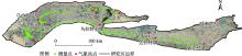
图1
研究区示意图"
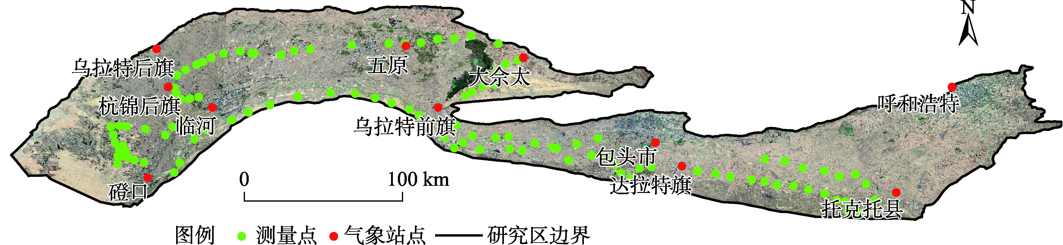

图2
模糊隶属函数"
表1
土壤风蚀影响因子判断矩阵"
| 风蚀指标 | 土壤可蚀性 | 植被盖度 | 土壤含砂量 | 风蚀气候侵蚀力 | 地形起伏度 | 权重 |
|---|---|---|---|---|---|---|
| 土壤可蚀性 | 1 | 1 | 2 | 7 | 9 | 0.3629 |
| 植被盖度 | 1 | 1 | 2 | 7 | 9 | 0.3629 |
| 土壤含砂量 | 1/2 | 1/2 | 1 | 3 | 5 | 0.1792 |
| 风蚀气候侵蚀力 | 1/7 | 1/7 | 1/3 | 1 | 2 | 0.0587 |
| 地形起伏度 | 1/7 | 1/9 | 1/5 | 1/2 | 1 | 0.0430 |
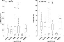
图3
不同土地利用类型的土壤硬度和抗剪强度"
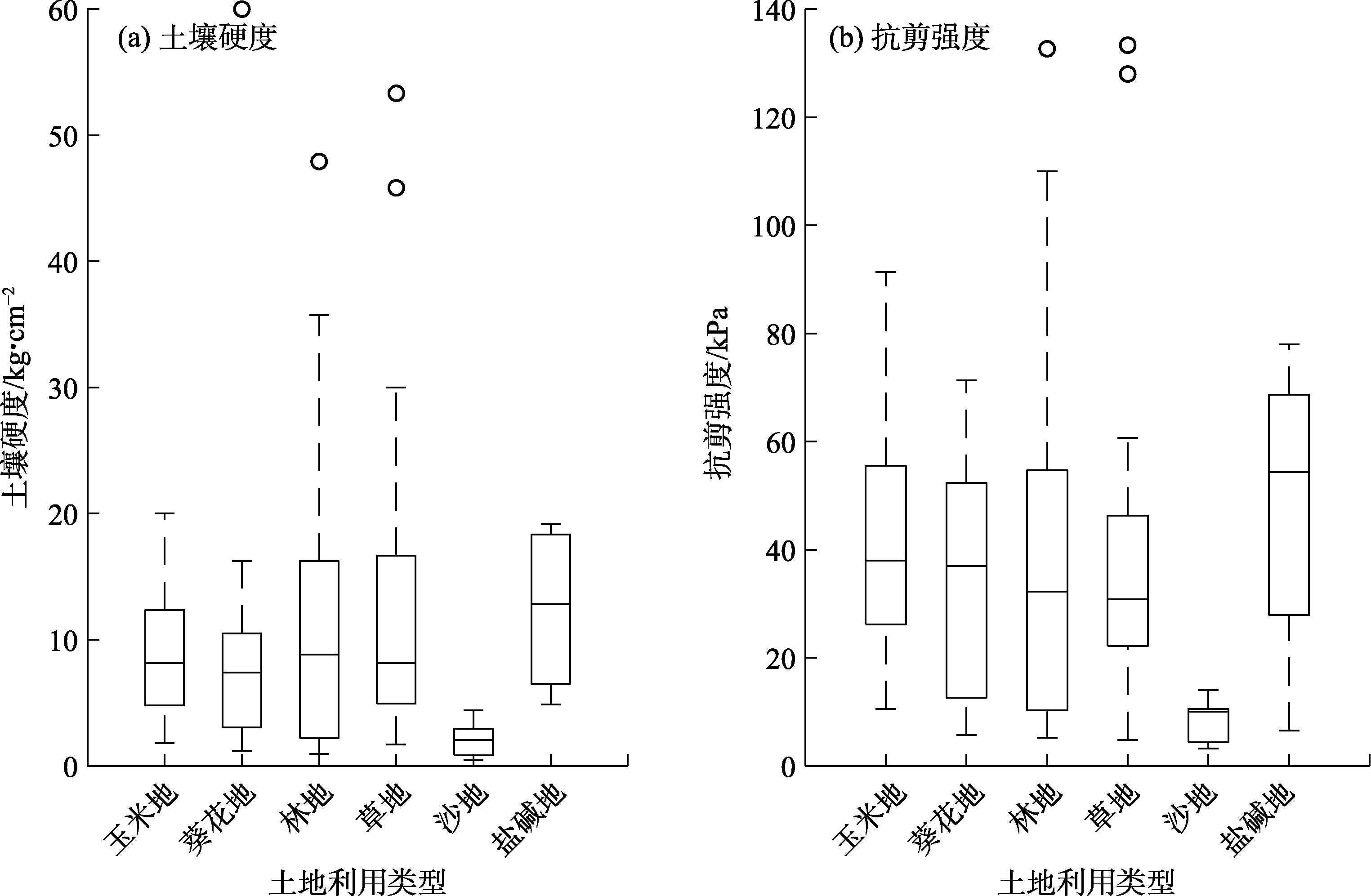
表2
不同土地利用类型的土壤可蚀性"
| 土地利用 类型 | 土壤含水率 /% | 抗剪强度中值 /kPa | 可蚀性指数 /m4·(kN)-2 |
|---|---|---|---|
| 草地 | 15.21 | 30.83 | 0.001025 |
| 林地 | 17.65 | 32.21 | 0.000964 |
| 耕地 | 17.48 | 37.50 | 0.000711 |
| 沙地 | 7.77 | 10.00 | 0.010000 |
| 盐碱地 | 61.95 | 54.33 | 0.000339 |
图4
河套平原风蚀指标敏感性"

图5
河套平原土壤风蚀风险评价结果"
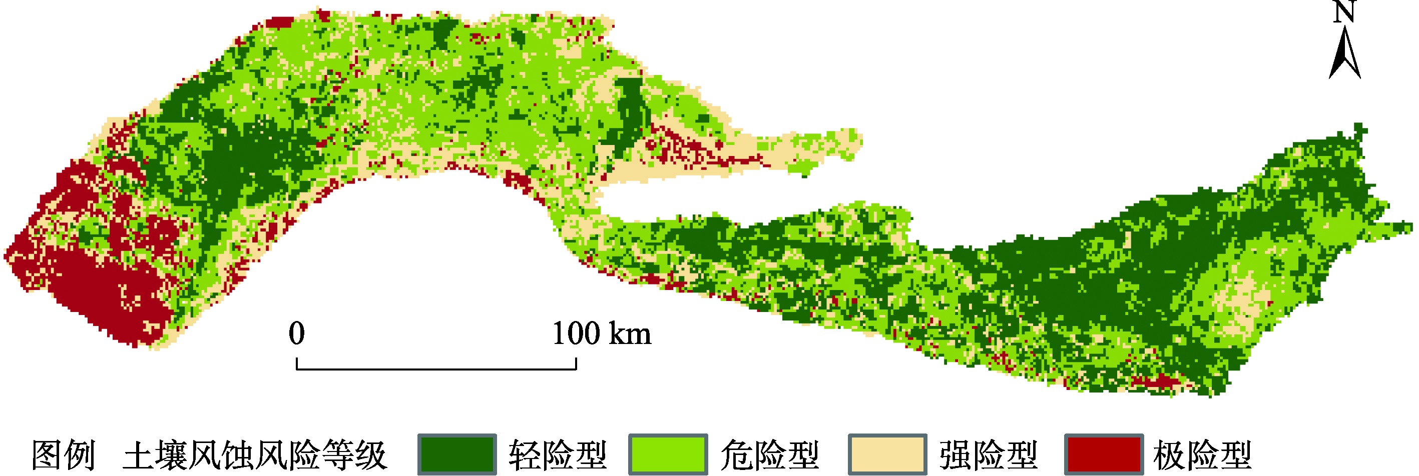
表3
土壤风蚀风险分级"
| 风蚀风险等级 | 土壤风蚀风 险评估指数 | 面积/km2 | 比例/% |
|---|---|---|---|
| 轻险型 | <0.266 | 9774 | 32.84 |
| 危险型 | 0.266~0.400 | 11800 | 39.65 |
| 强险型 | 0.400~0.641 | 5214 | 17.52 |
| 极险型 | >0.641 | 2974 | 9.99 |
| [1] | 董光荣, 李长治, 金炯, 等. 关于土壤风蚀风洞模拟实验的某些结果[J]. 科学通报, 1987, 32(4): 297-301. |
| [ Dong Guangrong, Li Changzhi, Jin Jiong, et al. Some results of wind tunnel simulation experiment on soil wind erosion[J]. Chinese Science Bulletin, 1987, 32(4): 297-301. ] | |
| [2] |
陈渭南, 董光荣, 董治宝. 中国北方土壤风蚀问题研究的进展与趋势[J]. 地球科学进展, 1994, 9(5): 6-12.
doi: 10.11867/j.issn.1001-8166.1994.05.0006 |
|
[ Chen Weinan, Dong Guangrong, Dong Zhibao. Achievements and needs of studies on wind erosion in northern China[J]. Advances in Earth Science, 1994, 9(5): 6-12. ]
doi: 10.11867/j.issn.1001-8166.1994.05.0006 |
|
| [3] |
邹学勇, 张春来, 程宏, 等. 土壤风蚀模型中的影响因子分类与表达[J]. 地球科学进展, 2014, 29(8): 875-889.
doi: 10.11867/j.issn.1001-8166.2014.08.0875 |
|
[ Zou Xueyong, Zhang Chunlai, Cheng Hong, et al. Classification and representation of factors affecting soil wind erosion in a model[J]. Advances in Earth Science, 2014, 29(8): 875-889. ]
doi: 10.11867/j.issn.1001-8166.2014.08.0875 |
|
| [4] | 南岭, 杜灵通, 展秀丽. 土壤风蚀可蚀性研究进展[J]. 土壤, 2014, 46(2): 204-211. |
| [ Nan Ling, Du Lingtong, Zhan Xiuli. Advances in study on soil erodibility for wind erosion[J]. Soils, 2014, 46(2): 204-211. ] | |
| [5] | 李晓佳, 海春兴, 刘广通. 阴山北麓不同用地方式下春季土壤可蚀性研究[J]. 干旱区地理, 2007, 30(6): 926-932. |
| [ Li Xiaojia, Hai Chunxing, Liu Guangtong. Spring soil erodibility for different land use patterns in the north piedmont of the Yinshan Mountains[J]. Arid Land Geography, 2007, 30(6): 926-932. ] | |
| [6] | 李驰, 黄浩, 孙兵兵, 等. 沙漠路基边坡抗风蚀能力现场试验研究[J]. 土木工程学报, 2011, 44(增刊2): 220-225. |
| [ Li Chi, Huang Hao, Sun Bingbing, et al. Field test study on the anti-wind erosion ability for desert roadbed slopes[J]. China Civil Engineering Journal, 2011, 44(Suppl. 2): 220-225. ] | |
| [7] | 师华定, 高庆先, 庄大方, 等. 基于径向基函数神经网络(RBFN)的内蒙古土壤风蚀危险度评价[J]. 环境科学研究, 2008, 21(5): 129-133. |
| [ Shi Huading, Gao Qingxian, Zhuang Dafang, et al. Using RBFN model and GIS technique to assess wind erosion hazard in Inner Mongolia[J]. Research of Environmental Sciences, 2008, 21(5): 129-133. ] | |
| [8] | 杨光华, 包安明, 陈曦, 等. 基于RBFN模型的新疆土壤风蚀危险度评价[J]. 中国沙漠, 2010, 30(5): 1137-1145. |
| [ Yang Guanghua, Bao Anming, Chen Xi, et al. Wind erosion hazard assessment in Xinjiang based on RBFN model[J]. Journal of Desert Research, 2010, 30(5): 1137-1145. ] | |
| [9] |
刘新颜, 曹晓仪, 董治宝. 基于T-S模糊神经网络模型的榆林市土壤风蚀危险度评价[J]. 地理科学, 2013, 33(6): 741-747.
doi: 10.13249/j.cnki.sgs.2013.06.741 |
|
[ Liu Xinyan, Cao Xiaoyi, Dong Zhibao. Soil wind erosion risk assessment in Yulin City using T-S fuzzy neural network model[J]. Scientia Geographica Sinica, 2013, 33(6): 741-747. ]
doi: 10.13249/j.cnki.sgs.2013.06.741 |
|
| [10] |
师华定, 高庆先, 齐永清, 等. 蒙古高原土壤风蚀危险度的FCM模糊聚类研究[J]. 自然资源学报, 2009, 24(5): 881-889.
doi: 10.11849/zrzyxb.2009.05.015 |
|
[ Shi Huading, Gao Qingxian, Qi Yongqing, et al. Wind erosion hazard assessment of Mongolian Plateau by using FMC fuzzy cluster method[J]. Journal of Natural Resources, 2009, 24(5): 881-889. ]
doi: 10.11849/zrzyxb.2009.05.015 |
|
| [11] | 曹晓仪, 董治宝, 李静, 等. 基于GIS的榆林市土壤风蚀危险度评价[J]. 水土保持通报, 2013, 33(1): 206-210. |
| [ Cao Xiaoyi, Dong Zhibao, Li Jing, et al. GIS-based evaluation of soil erosion risk by wind in Yulin City of Shaanxi Province[J]. Bulletin of Soil and Water Conservation, 2013, 33(1): 206-210. ] | |
| [12] | 孙传龙, 张卓栋, 邱倩倩. 基于层次分析法的锡林郭勒草地景观系统风蚀危险性分析[J]. 干旱区地理, 2016, 39(5): 1036-1042. |
| [ Sun Chuanlong, Zhang Zhuodong, Qiu Qianqian. AHP based wind erosion risk analysis of the Xilinguole grassland landscape system[J]. Arid Land Geography, 2016, 39(5): 1036-1042. ] | |
| [13] | 杜鹤强, 薛娴, 王涛. 黄河上游宁夏-内蒙古段跃移沙粒起动风速的空间分布[J]. 农业工程学报, 2013, 29(14): 210-219. |
| [ Du Heqiang, Xue Xian, Wang Tao. Spatial distribution of threshold wind velocity for sand saltation in Ningxia-Inner Mongolia reach of upstream of Yellow River[J]. Transactions of the Chinese Society of Agricultural Engineering, 2013, 29(14): 210-219. ] | |
| [14] | 邢丽珠, 张方敏, 邢开成, 等. 基于RWEQ模型的内蒙古巴彦淖尔市土壤风蚀变化特征及归因分析[J]. 中国沙漠, 2021, 41(5): 111-119. |
| [ Xing Lizhu, Zhang Fangmin, Xing Kaicheng, et al. Change of soil wind erosion and attribution in Bayannur, Inner Mongolia based on the revised wind erosion equation[J]. Journal of Desert Research, 2021, 41(5): 111-119. ] | |
| [15] | 张正偲, 董治宝, 赵爱国, 等. 输沙量与输沙势的关系[J]. 中国沙漠, 2011, 31(4): 824-827. |
| [ Zhang Zhengcai, Dong Zhibao, Zhao Aiguo, et al. Relationship between sand transport and sand drift potential[J]. Journal of Desert Research, 2011, 31(4): 824-827. ] | |
| [16] | 陈首序, 董玉祥. 风蚀气候侵蚀力研究进展[J]. 中国沙漠, 2020, 40(5): 65-73. |
| [ Chen Shouxu, Dong Yuxiang. A review of the research on wind erosion climatic erosivity[J]. Journal of Desert Research, 2020, 40(5): 65-73. ] | |
| [17] | 王永, 赵举, 程玉臣. 阴山北麓农牧交错带风蚀气候侵蚀力的计算与分析[J]. 华北农学报, 2005, 20(增刊1): 57-60. |
| [ Wang Yong, Zhao Ju, Cheng Yuchen. Analysis of wind erosion climatic erosivity at agri-pasture transition zone in north area of Yinshan Mountain[J]. Acta Agriculturae Boreali-Sinica, 2005, 20(Suppl. 1): 57-60. ] | |
| [18] |
刘慧, 李晓英, 肖建华, 等. 1961—2015年雅鲁藏布江流域风蚀气候侵蚀力变化[J]. 地理科学, 2019, 39(4): 688-695.
doi: 10.13249/j.cnki.sgs.2019.04.019 |
|
[ Liu Hui, Li Xiaoying, Xiao Jianhua, et al. Variations of wind erosion climatic erosivity in the Yarlung Zangbo River Basin during 1961—2015[J]. Scientia Geographica Sinica, 2019, 39(4): 688-695. ]
doi: 10.13249/j.cnki.sgs.2019.04.019 |
|
| [19] | 王翔宇, 原鹏飞, 丁国栋, 等. 不同植被覆盖防治土壤风蚀对比研究[J]. 水土保持研究, 2008, 15(5): 38-41. |
| [ Wang Xiangyu, Yuan Pengfei, Ding Guodong, et al. Study on mechanism between natural shrub-grass and soil wind erosion[J]. Research of Soil and Water Conservation, 2008, 15(5): 38-41. ] | |
| [20] | 杨文斌, 李卫, 党宏忠, 等. 低覆盖度治沙——原理、模式与效果[M]. 北京: 科学出版社, 2016. |
| [ Yang Wenbin, Li Wei, Dang Hongzhong, et al. Desertification control with low coverage vegetation: Principle, mode and effect[M]. Beijing: Science Press, 2016. ] | |
| [21] | 胡孟春, 刘玉章, 乌兰, 等. 科尔沁沙地土壤风蚀的风洞实验研究[J]. 中国沙漠, 1991, 11(1): 25-32. |
| [ Hu Mengchun, Liu Yuzhang, Wu Lan, et al. A experimental study in wind tunnel on wind erosion of soil in Korqin Sandy Land[J]. Journal of Desert Research, 1991, 11(1): 25-32. ] | |
| [22] | 杨望, 张硕, 杨坚, 等. 收获期木薯地耕作层土壤硬度的试验研究[J]. 农机化研究, 2015, 37(7): 176-180. |
| [ Yang Wang, Zhang Shuo, Yang Jian, et al. Experimental study on soil hardness of cultivated horizon at cassava cultivated farm in harvesting period[J]. Journal of Agricultural Mechanization Research, 2015, 37(7): 176-180. ] | |
| [23] |
Fallahzade J, Karimi A, Naderi M, et al. Soil mechanical properties and wind erosion following conversion of desert to irrigated croplands in central Iran[J]. Soil and Tillage Research, 2020, 204: 104665, doi: 10.1016/j.still.2020.104665.
doi: 10.1016/j.still.2020.104665 |
| [24] |
Zhang C, Wang X, Zou X, et al. Estimation of surface shear strength of undisturbed soils in the eastern part of northern China’s wind erosion area[J]. Soil and Tillage Research, 2018, 178: 1-10.
doi: 10.1016/j.still.2017.12.014 |
| [25] |
Wang Z T, Wang H T, Niu Q H, et al. Abrasion of yardangs[J]. Physical Review E, 2011, 84(3): 031304, doi: 10.1103/PhysRevE.84.031304.
doi: 10.1103/PhysRevE.84.031304 |
| [26] |
Wang Z T. Erosion model for brittle materials under low-speed impacts[J]. Journal of Tribology, 2020, 142(7): 074501, doi: 10.1115/1.4046019.
doi: 10.1115/1.4046019 |
| [27] | 吴盈盈, 刘旭阳, 王振亭. 干燥致密土壤在沙粒流冲击下的磨蚀规律[J]. 农业工程学报, 2022, 38(8): 315-320. |
| [ Wu Yingying, Liu Xuyang, Wang Zhenting. Abrasion law of dry and dense soil under the bombardment of sand grain flows[J]. Transactions of the Chinese Society of Agricultural Engineering, 2022, 38(8): 315-320. ] | |
| [28] | 李振山. 地形起伏对气流速度影响的风洞实验研究[J]. 水土保持研究, 1999, 6(4): 75-79. |
| [ Li Zhenshan. Wind tunnel simulation of flow velocity on the windward slope[J]. Research of Soil and Water Conservation, 1999, 6(4): 75-79. ] | |
| [29] |
Mirmousavi S H. Regional modeling of wind erosion in the north west and south west of Iran[J]. Eurasian Soil Science, 2016, 49(8): 942-953.
doi: 10.1134/S1064229316080081 |
| [30] |
Baumgertel A, Lukić S, Belanović Simić S, et al. Identifying areas sensitive to wind erosion: A case study of the AP Vojvodina (Serbia)[J]. Applied Sciences, 2019, 9(23): 5106, doi: 10.3390/app9235106.
doi: 10.3390/app9235106 |
| [31] | Mezősi G, Blanka V, Bata T, et al. Assessment of future scenarios for wind erosion sensitivity changes based on ALADIN and REMO regional climate model simulation data[J]. Open Geosciences, 2016, 8(1): 465-477. |
| [32] |
Borrelli P, Panagos P, Ballabio C, et al. Towards a pan-European assessment of land susceptibility to wind erosion[J]. Land Degradation & Development, 2016, 27(4): 1093-1105.
doi: 10.1002/ldr.2318 |
| [33] |
于国茂, 刘越, 艳燕, 等. 2000—2008年内蒙古中部地区土壤风蚀危险度评价[J]. 地理科学, 2011, 31(12): 1493-1499.
doi: 10.13249/j.cnki.sgs.2011.012.1493 |
|
[ Yu Guo-mao, Liu Yue, Yan Yan, et al. Soil wind erosion risk assessment in the middle part of Inner Mongolia Plateau during 2000 to 2008[J]. Scientia Geographica Sinica, 2011, 31(12): 1493-1499. ]
doi: 10.13249/j.cnki.sgs.2011.012.1493 |
|
| [34] | 胡孟春, 王周龙. 土壤风蚀的自然-社会复合系统动态过程模拟研究[J]. 科学通报, 1994, 39(12): 1118-1121. |
| [ Hu Mengchun, Wang Zhoulong. Study on dynamic process simulation of natural and social complex system of soil wind erosion[J]. Chinese Science Bulletin, 1994, 39(12): 1118-1121. ] | |
| [35] | 周颖, 曹月娥, 杨建军, 等. 准噶尔盆地东部土壤风蚀危险度评价[J]. 中国沙漠, 2016, 36(5): 1265-1270. |
| [ Zhou Ying, Cao Yue’e, Yang Jianjun, et al. Assessment of wind erosion hazard degree in the Zhundong area, Xinjiang, China[J]. Journal of Desert Research, 2016, 36(5): 1265-1270. ] | |
| [36] |
Mihi A, Benaradj A. Assessing and mapping wind erosion-prone areas in northeastern Algeria using additive linear model, fuzzy logic, multicriteria, GIS, and remote sensing[J]. Environmental Earth Sciences, 2022, 81(2): 1-21.
doi: 10.1007/s12665-021-10123-9 |
| [37] |
Khaboushan E A, Emami H, Mosaddeghi M R, et al. Estimation of unsaturated shear strength parameters using easily-available soil properties[J]. Soil and Tillage Research, 2018, 184: 118-127.
doi: 10.1016/j.still.2018.07.006 |
| [38] |
Feng B, Zong Q, Cai H, et al. Calculation of increased soil shear strength from desert plant roots[J]. Arabian Journal of Geosciences, 2019, 12(16): 1-12.
doi: 10.1007/s12517-018-4128-8 |
| [39] |
Zhang B, Zhao Q G, Horn R, et al. Shear strength of surface soil as affected by soil bulk density and soil water content[J]. Soil and Tillage Research, 2001, 59(3-4): 97-106.
doi: 10.1016/S0167-1987(01)00163-5 |
| [40] | 张扬, 田美荣, 陈艳梅, 等. 基于RWEQ模型的磴口县沙地与耕地风蚀评价及验证[J]. 干旱区资源与环境, 2021, 35(9): 95-102. |
| [ Zhang Yang, Tian Meirong, Chen Yanmei, et al. Evaluation and verification of wind erosion of sandy land and cultivated land in Dengkou County based on RWEQ model[J]. Journal of Arid Land Resources and Environment, 2021, 35(9): 95-102. ] |
| [1] | 王岱, 崔洋, 王素艳, 张雯. 1961—2020年宁夏干旱事件年代际变化及风险评估[J]. 干旱区地理, 2024, 47(5): 785-797. |
| [2] | 段钊, 李瑞怡, 宋昆, 闫旭升, 郑立才, 贺子光. 盐风化作用下黄土结构的破坏特征与机理[J]. 干旱区地理, 2024, 47(12): 2041-2050. |
| [3] | 陈满, 陈亚宁, 方功焕, 李玉朋, 孙慧兰. 昆仑山北坡冰川湖变化及其溃决风险评估[J]. 干旱区地理, 2024, 47(10): 1628-1639. |
| [4] | 蔺阿荣, 周冬梅, 马静, 朱小燕, 江晶, 张军. 基于RWEQ模型的疏勒河流域防风固沙功能价值评估[J]. 干旱区地理, 2024, 47(1): 58-67. |
| [5] | 史维良, 车璐阳, 李涛. 陕西省汛期极端降水概率分布及综合危险性评估[J]. 干旱区地理, 2023, 46(9): 1407-1417. |
| [6] | 李乐乐, 钞锦龙, 赵德一, 李浩杰, 吴林栋, 李佳骏. 1957—2019年山西省暴雨时空分布特征与暴雨灾害风险评估[J]. 干旱区地理, 2023, 46(5): 689-699. |
| [7] | 冯哲,刘瑞娟,白宇晨,常春平,郭中领,李继峰,王仁德,李庆. 农田近地表风沙流风程效应变化特征研究[J]. 干旱区地理, 2022, 45(5): 1500-1512. |
| [8] | 赵志欣,霍艾迪,张丹,易秀,陈思名,陈四宾,陈建. 基于遥感的宁夏地区高温热浪风险评估[J]. 干旱区地理, 2022, 45(2): 512-521. |
| [9] | 朱淑珍,黄法融,李兰海. 巴基斯坦干旱特征及其风险评估[J]. 干旱区地理, 2021, 44(4): 1058-1069. |
| [10] | 王佳庭, 于明含, 杨海龙, 吴其淦, 刘泰含 . 乌兰布和沙漠典型植物群落土壤风蚀可蚀性研究[J]. 干旱区地理, 2020, 43(6): 1543-1550. |
| [11] | 德勒格日玛, 韩理, 孟雪峰, 杭月河, 计艳霞, 张莫日根. 内蒙古牧区暴风雪风险评估研究[J]. 干旱区地理, 2019, 42(3): 469-477. |
| [12] | 裴艳茜, 邱海军, 胡胜, 杨冬冬, 曹明明, 邹强. “一带一路”地区滑坡灾害风险评估[J]. 干旱区地理, 2018, 41(6): 1225-1240. |
| [13] | 韩炳宏, 周秉荣, 吴让, 赵敏, 乜国妍, 牛得草, 傅华. 基于格网的青海省干旱灾害综合风险评估[J]. 干旱区地理, 2018, 41(6): 1194-1203. |
| [14] | 徐玉霞, 许小明, 马楠. 县域尺度下的陕西省洪涝灾害风险评估及区划[J]. 干旱区地理, 2018, 41(2): 306-313. |
| [15] | 刘春景, 唐敦兵, 王雷, 赵泽. 滴灌梯形迷宫滴头水力性能多目标优化[J]. 干旱区地理, 2016, 39(3): 600-606. |
| Viewed | ||||||||||||||||||||||||||||||||||||||||||||||||||
|
Full text 732
|
|
|||||||||||||||||||||||||||||||||||||||||||||||||
|
Abstract 336
|
|
|||||||||||||||||||||||||||||||||||||||||||||||||
Cited |
|
|||||||||||||||||||||||||||||||||||||||||||||||||
| Shared | ||||||||||||||||||||||||||||||||||||||||||||||||||
|
||