干旱区地理 ›› 2022, Vol. 45 ›› Issue (6): 1988-2003.doi: 10.12118/j.issn.1000-6060.2022.098
张佳宁1( ),姚林杰1,张恒瑞1,赵艳云1,张庆1,2,3,刘朋涛4()
收稿日期:2022-03-13
修回日期:2022-04-18
出版日期:2022-11-25
发布日期:2023-02-01
通讯作者:
刘朋涛(1980-),男,高级工程师,博士,主要从事草地生态和应用气象研究. E-mail: 作者简介:张佳宁(1998-),女,在读硕士,主要从事景观生态学研究. E-mail: 基金资助:
ZHANG Jianing1(),YAO Linjie1,ZHANG Hengrui1,ZHAO Yanyun1,ZHANG Qing1,2,3,LIU Pengtao4()
Received:2022-03-13
Revised:2022-04-18
Online:2022-11-25
Published:2023-02-01
Contact:
Pengtao LIU
摘要:
可持续性可通过区域生态足迹水平进行衡量。采用净初级生产力构建了内蒙古各盟(市)草地资源的均衡因子和产量因子。以每5 a为一期,测算了内蒙古草地1990—2020年的生态足迹,并结合人口分布数据刻画了生态足迹的空间分布状况;在此基础上应用土地可持续模型评价了内蒙古草地资源的可持续性。结果表明:(1) 内蒙古各盟(市)草地的产量因子差异较大,整体呈东高西低的特点。(2) 生态承载力在空间上也呈东高西低特点,30 a人均生态承载力整体呈小幅度下降趋势。(3) 人均生态足迹逐期上升,2000—2005年由生态盈余转变为生态赤字。生态足迹较高的区域集中在通辽市、锡林浩特市、二连浩特市、乌兰察布市南部和鄂尔多斯市东部地区。(4) 内蒙古草地资源可持续性逐期下降,由1990年的中度可持续性退化为2020年的弱不可持续性。可持续性退化严重的区域集中在呼和浩特市、包头市和乌海市。研究结果旨在为内蒙古草地资源的可持续利用提供可靠的理论基础。
张佳宁, 姚林杰, 张恒瑞, 赵艳云, 张庆, 刘朋涛. 内蒙古草地资源的生态足迹及其可持续利用分析[J]. 干旱区地理, 2022, 45(6): 1988-2003.
ZHANG Jianing, YAO Linjie, ZHANG Hengrui, ZHAO Yanyun, ZHANG Qing, LIU Pengtao. Ecological footprint and sustainable utilization of grassland resources in Inner Mongolia[J]. Arid Land Geography, 2022, 45(6): 1988-2003.
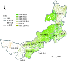
图1
内蒙古自治区行政区划及草地资源分布 注:该图基于国家测绘地理信息局标准地图服务网站下载的审图号为GS(2019)3333号的标准地图制作,底图边界无修改。下同。"

表1
土地利用可持续性等级划分"
| 取值区间 | 可持续性程度 |
|---|---|
| 0.9<LUSC<1.0 | 极强可持续性 |
| 0.8<LUSC≤0.9 | 强可持续性 |
| 0.7<LUSC≤0.8 | 中度可持续性 |
| 0.6<LUSC≤0.7 | 弱可持续性 |
| 0.4<LUSC≤0.6 | 临界状态 |
| 0.3<LUSC≤0.4 | 弱不可持续性 |
| 0.2<LUSC≤0.3 | 中度不可持续性 |
| 0.1<LUSC≤0.2 | 强不可持续性 |
| 0.0<LUSC≤0.1 | 极强不可持续性 |
表2
各盟(市)草地均衡因子与产量因子"
| 盟(市) | 均衡因子 | 产量因子 |
|---|---|---|
| 呼和浩特市 | 0.95 | 0.95 |
| 包头市 | 0.88 | 0.51 |
| 呼伦贝尔市 | 0.82 | 1.55 |
| 兴安盟 | 0.97 | 1.52 |
| 通辽市 | 0.96 | 1.13 |
| 赤峰市 | 0.95 | 1.18 |
| 锡林郭勒盟 | 0.97 | 0.82 |
| 乌兰察布市 | 0.86 | 0.74 |
| 鄂尔多斯市 | 0.97 | 0.58 |
| 巴彦淖尔市 | 0.86 | 0.48 |
| 乌海市 | 0.94 | 0.34 |
| 阿拉善盟 | 0.97 | 0.49 |
| 平均值 | 0.92 | 0.86 |
| 变异系数/% | 5.95 | 48.14 |
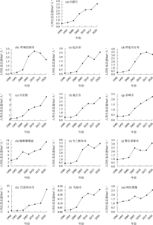
图2
内蒙古草地资源人均生态足迹变化趋势"

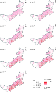
图3
内蒙古草地资源生态足迹空间格局变化趋势"


图4
内蒙古草地资源人均生态承载力变化趋势"
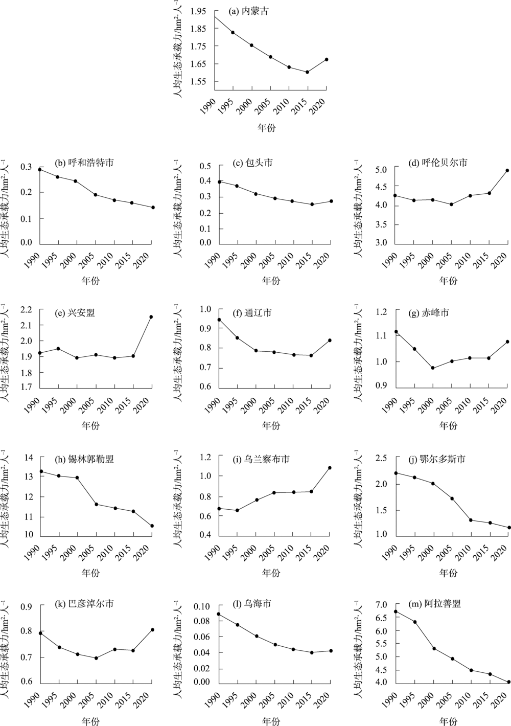
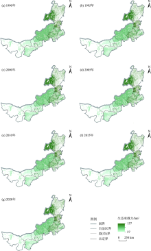
图5
内蒙古草地资源生态承载力空间格局变化趋势"


图6
内蒙古草地资源生态赤字变化趋势"
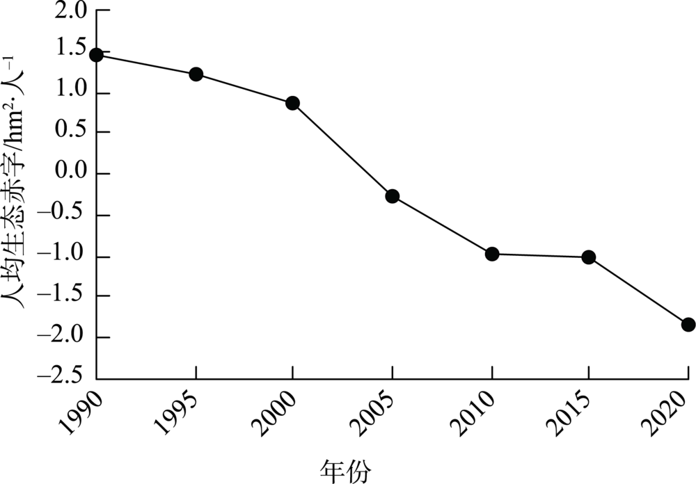
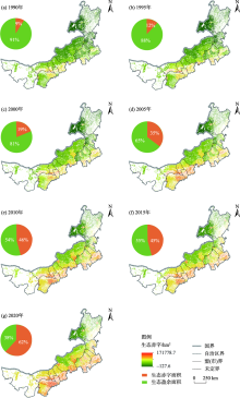
图7
内蒙古草地资源生态赤字空间格局变化趋势"


图8
内蒙古草地资源可持续性变化趋势 注:LUSC为土地利用可持续性系数。下同。"
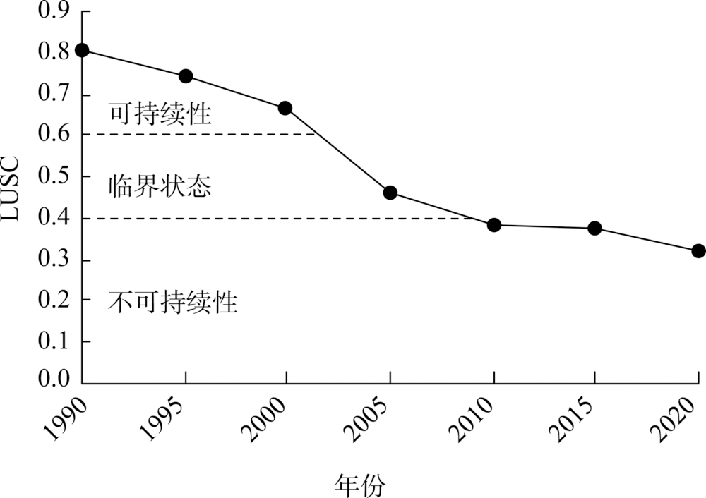
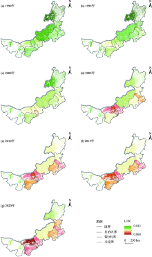
图9
内蒙古草地资源可持续性变化趋势"

| [1] |
Reynolds J F, Smith D, Lambin E F, et al. Global desertification: Building a science for dryland evelopment[J]. Science, 2007, 316(5826): 847-851.
doi: 10.1126/science.1131634 pmid: 17495163 |
| [2] | 张美玲, 陈全功, 蒋文兰. 不同草地类型净初级生产力(NPP)模拟及其敏感性分析[J]. 干旱区地理, 2021, 44(2): 369-378. |
| [Zhang Meiling, Chen Quangong, Jiang Wenlan. Simulation and sensitivity analysis of net primary productivity (NPP) of different grassland types[J]. Arid Land Geography, 2021, 44(2): 369-378.] | |
| [3] | 孙祥. 中国半干旱与干旱地区草地资源的主要类型、特征与合理利用[J]. 干旱区资源与环境, 1989, 3(1): 92-103. |
| [Sun Xiang. Brief classifications, characteristcs and rational utilizations of the grassland resources in the arid and semiarid regions of China[J]. Journal of Arid Land Resources and Environment, 1989, 3(1): 92-103.] | |
| [4] | 李毓堂. 中国草原政策的变迁[J]. 草业科学, 2008, 25(6): 1-7. |
| [Li Yutang. The change of grassland policy in China[J]. Pratacultural Science, 2008, 25(6): 1-7.] | |
| [5] | 黄润秋. 深入贯彻落实十九届五中全会精神协同推进生态环境高水平保护和经济高质量发展——在2021年全国生态环境保护工作会议上的工作报告[J]. 中国生态文明, 2021, 9(1): 12-23. |
| [Huang Runqiu. Thoroughly implement the spirit of the fifth plenary session of the 19th CPC Central Committee, coordinate to promote high-level protection of ecological environment and high-quality economic development[J]. China Ecological Civilization, 2021, 9(1): 12-23.] | |
| [6] | Baabou W, Grunewald N, Ouellet-Plamondon C, et al. The ecological footprint of Mediterranean cities: Awareness creation and policy implications[J]. Environmental Science & Policy, 2017, 69: 94-104. |
| [7] | 刘秀丽, 张勃, 昝国江, 等. 基于生态足迹的甘肃省耕地资源可持续利用与情景预测[J]. 干旱区地理, 2013, 36(1): 84-91. |
| [Liu Xiuli, Zhang Bo, Zan Guojiang, et al. Sustainable use and scenario prediction of cultivated land in Gansu Province based on ecological footprint theory[J]. Arid Land Geography, 2013, 36(1): 84-91.] | |
| [8] |
Wackernagel M, Onisto L, Bello P, et al. National natural capital accounting with the ecological footprint concept[J]. Ecological Economics, 1999, 29(3): 375-390.
doi: 10.1016/S0921-8009(98)90063-5 |
| [9] |
Wackernagel M, Rees W E. Perceptual and structural barriers to investing in natural capital: Economics from an ecological footprint perspective[J]. Ecological Economics, 1997, 20(1): 3-24.
doi: 10.1016/S0921-8009(96)00077-8 |
| [10] | 徐中民, 张志强, 程国栋. 甘肃省1998年生态足迹计算与分析[J]. 地理学报, 2000, 67(5): 607-616. |
| [Xu Zhongmin, Zhang Zhiqiang, Cheng Guodong. The calculation and analysis of ecological footprints of Gansu Province[J]. Acta Geographica Sinica, 2000, 67(5): 607-616.] | |
| [11] |
Wackernagel M, Monfreda C, Erb K H, et al. Ecological footprint time series of Austria, the Philippines, and South Korea for 1961—1999: Comparing the conventional approach to an actual land area’ approach[J]. Land Use Policy, 2004, 21(3): 261-269.
doi: 10.1016/j.landusepol.2003.10.007 |
| [12] | 王菲凤, 陈妃. 福州大学城校园生态足迹和生态效率实证研究[J]. 福建师范大学学报(自然科学版), 2008, 24(5): 84-89. |
| [Wang Feifeng, Chen Fei. Research on ecological footprint and efficiency of the university campuses in Fuzhou City[J]. Journal of Fujian Normal University (Natural Science Edition), 2008, 24(5): 84-89.] | |
| [13] |
Rashid A, Irum A, Malik I A, et al. Ecological footprint of Rawalpindi: Pakistan’s first footprint analysis from urbanization perspective[J]. Journal of Cleaner Production, 2018, 170: 362-368.
doi: 10.1016/j.jclepro.2017.09.186 |
| [14] | 李菲, 张小平. 甘肃省水资源生态足迹和生态承载力时空特征[J]. 干旱区地理, 2020, 43(6): 1486-1495. |
| [Li Fei, Zhang Xiaoping. Spatio-temporal characteristics of ecological footprint and ecological carrying capacity of water resources in Gansu Province[J]. Arid Land Geography, 2020, 43(6): 1486-1495.] | |
| [15] | 刘钦普, 林振山. 江苏省耕地利用可持续性动态分析及预测[J]. 自然资源学报, 2009, 24(4): 594-601. |
| [Liu Qinpu, Lin Zhenshan. Dynamic analysis and prediction on ecological footprint of Jiangsu’s cropland[J]. Journal of Natural Resources, 2009, 24(4): 594-601.] | |
| [16] | 吕越, 陈忠清. 能值生态足迹改进模型研究——以新疆为例[J]. 干旱区地理, 2016, 39(5): 1120-1127. |
| [Lü Yue, Chen Zhongqing. Improved model of emergy ecological footprint: A case study of Xinjiang[J]. Arid Land Geography, 2016, 39(5): 1120-1127.] | |
| [17] |
Bicknell K B, Ball R J, Cullen R, et al. New methodology for the ecological footprint with an application to the New Zealand economy[J]. Ecological Economics, 1998, 27(2): 149-160.
doi: 10.1016/S0921-8009(97)00136-5 |
| [18] |
Ferng J J. Toward a scenario analysis framework for energy footprints[J]. Ecological Economics, 2002, 40(1): 53-69.
doi: 10.1016/S0921-8009(01)00270-1 |
| [19] | Venetoulis J, Talberth J. Refining the ecological footprint[J]. Environment Development & Sustainability, 2008, 10(4): 441-469. |
| [20] | 刘某承, 李文华. 基于净初级生产力的中国生态足迹均衡因子测算[J]. 自然资源学报, 2009, 24(9): 401-406. |
| [Liu Moucheng, Li Wenhua. Calculation of ecological footprint equivalence factor in China based on net primary production[J]. Journal of Natural Resources, 2009, 24(9): 401-406.] | |
| [21] | 刘某承, 李文华, 谢高地. 基于净初级生产力的中国生态足迹产量因子测算[J]. 生态学杂志, 2010, 29(3): 592-597. |
| [Liu Moucheng, Li Wenhua, Xie Gaodi. Calculation of ecological footprint yield factor in China based on net primary production[J]. Chinese Journal of Ecology, 2010, 29(3): 592-597.] | |
| [22] |
Zhao S, Li Z, Li W. A modified method of ecological footprint calculation and its application[J]. Ecological Modelling, 2005, 185(1): 65-75.
doi: 10.1016/j.ecolmodel.2004.11.016 |
| [23] |
Niccolucci V, Bastianoni S, Tiezzi E, et al. How deep is the footprint? A 3D representation[J]. Ecological Modelling, 2009, 220(20): 2819-2823.
doi: 10.1016/j.ecolmodel.2009.07.018 |
| [24] |
方恺. 生态足迹深度和广度: 构建三维模型的新指标[J]. 生态学报, 2013, 33(1): 267-274.
doi: 10.5846/stxb201111051670 |
|
[Fang Kai. Ecological footprint depth and size: New indicators for a 3D model[J]. Acta Ecologica Sinica, 2013, 33(1): 267-274.]
doi: 10.5846/stxb201111051670 |
|
| [25] | 方恺, 李焕承. 基于生态足迹深度和广度的中国自然资本利用省际格局[J]. 自然资源学报, 2012, 27(12): 1995-2005. |
| [Fang Kai, Li Huancheng. Provincial pattern of China’s natural capital use: A modification and application of ecological footprint depth and size[J]. Journal of Natural Resources, 2012, 27(12): 1995-2005.] | |
| [26] | 徐中民, 程国栋, 张志强. 生态足迹方法:可持续性定量研究的新方法——以张掖地区1995年的生态足迹计算为例[J]. 生态学报, 2001, 21(9): 1484-1493. |
| [Xu Zhongmin, Cheng Guodong, Zhang Zhiqiang. Measuring sustainable development with the ecological footprint method: Take Zhangye Prefecture as an example[J]. Acta Ecologica Sinica, 2001, 21(9): 1484-1493.] | |
| [27] | 张志强, 徐中民, 程国栋, 等. 中国西部12省(区市)的生态足迹[J]. 地理学报, 2001, 56(5): 598-609. |
| [Zhang Zhiqiang, Xu Zhongmin, Cheng Guodong, et al. The ecological footprints of the 12 provinces of west China in 1999[J]. Acta Geographica Sinica, 2001, 56(5): 598-609.] | |
| [28] | 林聪, 李小磊, 杨楠, 等. 遥感产品支持的城市群生态足迹空间格局研究——以长江三角洲核心区城市群为例[J]. 地理与地理信息科学, 2018, 34(3): 20-25. |
| [Lin Cong, Li Xiaolei, Yang Nan, et al. A study on spatial pattern of ecological footprint for urban agglomeration combined with remote sensing products: A case study of urban agglomeration in the Yangtze River Delta[J]. Geography and Geo-Information Science, 2018, 34(3): 20-25.] | |
| [29] |
Zou X P, Song D J, Chen S F. Ecological carrying capacity of grasslands and animal husbandry sustainability in Central Asia[J]. Journal of Resources and Ecology, 2019, 10(6): 598-604.
doi: 10.5814/j.issn.1674-764X.2019.06.004 |
| [30] |
李辉, 红英, 邓国荣, 等. 1982—2015年气候变化和人类活动对内蒙古草地净初级生产力的影响[J]. 应用生态学报, 2021, 32(2): 415-424.
doi: 10.13287/j.1001-9332.202102.002 |
|
[Li Hui, Hong Ying, Deng Guorong, et al. Impacts of climate change and human activities on net primary productivity of grasslands in Inner Mongolia,China during 1982—2015[J]. Chinese Journal of Applied Ecology, 2021, 32(2): 415-424.]
doi: 10.13287/j.1001-9332.202102.002 |
|
| [31] | 刘皓宇, 姜艳丰. 1961—2018年内蒙古年平均气温的变化特征[J]. 内蒙古科技与经济, 2020, 24(20): 63-64. |
| [Liu Haoyu, Jiang Yanfeng. Variation characteristics of annual mean temperature in Inner Mongolia from 1961 to 2018[J]. Inner Mongolia Science Technology & Economy, 2020, 24(20): 63-64.] | |
| [32] | 邢丽珠, 张方敏, 黄进, 等. 1961—2018年内蒙古6级及以上大风日数时空变化特征[J]. 干旱区地理, 2021, 44(5): 1290-1298. |
| [Xing Lizhu, Zhang Fangmin, Huang Jin, et al. Spatial and temporal changes of high wind days over category 6 and above in Inner Mongolia from 1961 to 2018[J]. Arid Land Geography, 2021, 44(5): 1290-1298.] | |
| [33] | 张帅, 董泽琴, 王海鹤, 等. 基于生态足迹改进模型的均衡因子与产量因子计算——以某市为例[J]. 安徽农业科学, 2010, 38(14): 7496-7498. |
| [Zhang Shuai, Dong Zeqin, Wang Haihe, et al. Calculation of equivalence factor and yield factor based on modified ecological footprint model[J]. Journal of Anhui Agricultural Sciences, 2010, 38(14): 7496-7498.] | |
| [34] | 张静宇, 李奉时, 张双双, 等. 基于净初级生产力的内蒙古均衡因子测算及其对气候的响应[J]. 内蒙古大学学报(自然科学版), 2021, 52(1): 95-103. |
| [Zhang Jingyu, Li Fengshi, Zhang Shuangshuang, et al. Calculation of equivalence factor in Inner Mongolia based on net primary production and its response to climate[J]. Journal of Inner Mongolia University (Natural Science Edition), 2021, 52(1): 95-103.] | |
| [35] | 鲁凤, 陶菲, 钞振华, 等. 基于净初级生产力的省公顷生态足迹模型参数的计算——以江苏省为例[J]. 地理与地理信息科学, 2016, 32(2): 83-88. |
| [Lu Feng, Tao Fei, Chao Zhenhua, et al. Calculation of ecological footprint model coefficients based on net primary productivity: A case study of Jiangsu[J]. Geography and Geo-Information Science, 2016, 32(2): 83-88.] | |
| [36] |
徐中民, 程国栋, 张志强, 等. 中国1999年生态足迹计算与发展能力分析[J]. 应用生态学报, 2003, 14(2): 280-285.
pmid: 12827888 |
|
[Xu Zhongmin, Cheng Guodong, Zhang Zhiqiang, et al. Ecological footprint calculation and development capacity analysis of China in 1999[J]. Chinese Journal of Applied Ecology, 2003, 14(2): 280-285.]
pmid: 12827888 |
|
| [37] | 苏娇萍, 李智国. 基于改进生态足迹模型的云南省耕地可持续利用研究[J]. 云南农业大学学报(自然科学版), 2021, 36(1): 124-131. |
| [Su Jiaoping, Li Zhiguo. Research on the sustainable utilization of cultivated land based on improved ecological footprint model in Yunnan Province[J]. Journal of Yunnan Agricultural University (Natural Science Edition), 2021, 36(1): 124-131.] | |
| [38] | Keeble B R. The brundtland report: ‘Our common future’[J]. Medicine Conflict and Survival, 1988, 4(1): 17-25. |
| [39] | 赵兴国, 潘玉君, 丁生, 等. 中国省域土地利用可持续性评价及时空格局特征[J]. 农业工程学报, 2014, 30(3): 196-204. |
| [Zhao Xingguo, Pan Yujun, Ding Sheng, et al. Evaluation of regional land use sustainability and its spatial-temporal pattern among provinces in China[J]. Transactions of the Chinese Society of Agricultural Engineering, 2014, 30(3): 196-204.] | |
| [40] | 赵兴国, 潘玉君, 王爽, 等. 云南省耕地资源利用的可持续性及其动态预测——基于“国家公顷”的生态足迹新方法[J]. 资源科学, 2011, 33(3): 542-548. |
| [Zhao Xingguo, Pan Yujun, Wang Shuang, et al. Dynamic analysis of sustainablity of arable land resources use in Yunnan Province: A new method of ecological footprint based on national hectare[J]. Resources Science, 2011, 33(3): 542-548.] | |
| [41] |
Han F, Kang S, Buyantuev A, et al. Effects of climate change on primary production in the Inner Mongolia Plateau, China[J]. International Journal of Remote Sensing, 2016, 37(23-24): 5551-5564.
doi: 10.1080/01431161.2016.1230286 |
| [42] | 徐雪, 史国锋, 姚林杰, 等. 内蒙古毛乌素沙地生态足迹及驱动因素[J]. 内蒙古大学学报(自然科学版), 2021, 52(4): 381-391. |
| [Xu Xue, Shi Guofeng, Yao Linjie, et al. Ecological footprint and driving forces in Mu Us Sandy Land in Inner Mongolia[J]. Journal of Inner Mongolia University (Natural Science Edition), 2021, 52(4): 381-391.] | |
| [43] | 侯向阳, 尹燕亭, 丁勇. 中国草原适应性管理研究现状与展望[J]. 草业学报, 2011, 20(2): 262-269. |
| [Hou Xiangyang, Yin Yanting, Ding Yong. An overview and prospects for grassland adaptive management in China[J]. Acta Prataculturae Sinica, 2011, 20(2): 262-269.] | |
| [44] |
乌兰图雅. 蒙古高原草地利用特征及其国别差异[J]. 地理学报, 2021, 76(7): 1722-1731.
doi: 10.11821/dlxb202107011 |
|
[Wulan Tuya. Characteristics of grassland utilization in Mongolian Plateau and their differences among countries[J]. Acta Geographica Sinica, 2021, 76(7): 1722-1731.]
doi: 10.11821/dlxb202107011 |
|
| [45] | 韦惠兰, 祁应军. 不同规模草地超载主体的差异性——以甘肃省玛曲县为例[J]. 草业科学, 2017, 34(4): 892-901. |
| [Wei Huilan, Qi Yingjun. Differential analysis of herdsmen of different size scales and main contributors to grassland overgrazing: A case study in Maqu, Gansu Province[J]. Pratacultural Science, 2017, 34(4): 892-901.] | |
| [46] | 胡振通, 柳荻, 靳乐山. 草原超载过牧的牧户异质性研究[J]. 中国农业大学学报, 2017, 22(6): 158-167. |
| [Hu Zhentong, Liu Di, Jin Leshan. Study on herdsman level heterogeneity of grassland overgrazing[J]. Journal of China Agricultural University, 2017, 22(6): 158-167.] | |
| [47] | 陈晓杰, 王静, 孔雪松, 等. 武汉城市圈生态足迹时空差异及其与经济发展的协同性[J]. 生态学杂志, 2020, 39(10): 3452-3462. |
| [Chen Xiaojie, Wang Jing, Kong Xuesong, et al. Spatiotemporal differences of ecological footprints and synergistic relationship to economic development in Wuhan urban agglomeration[J]. Chinese Journal of Ecology, 2020, 39(10): 3452-3462.] | |
| [48] | 布仁吉日嘎拉, 浩日娃, 刘洋洋. 新中国成立70年内蒙古自治区牧区经济政策演进及其发展效应[J]. 中央民族大学学报(哲学社会科学版), 2019, 46(6): 27-36. |
| [Burenjargal Tangudai, Horiwa, Liu Yangyang. Seventy years’ progress and development effect of the economic policies in Inner Mongolia’s pastoral area since setting up of People’s Republic of China[J]. Journal of Minzu University of China (Philosophy and Social Sciences Edition), 2019, 46(6): 27-36.] | |
| [49] | 郝俊峰, 高征西, 闵慧. 浅析我国潜在优势非金属矿产资源的开发利用与保护——以内蒙古乌兰察布市石墨、萤石、电气石矿为例[J]. 西部资源, 2015, 12(2): 86-88, 91. |
| [Hao Junfeng, Gao Zhengxi, Min Hui. Study on exploitation and protection of potential advantages non-metallic mineral resources in China: Case in graphite, fluorite, tourmaline in Ulanqab, Inner Mongolia[J]. Western Resources, 2015, 12(2): 86-88, 91.] | |
| [50] | 李伊明, 刘佳媛, 史国良, 等. 呼包鄂地区冬季、夏季PM2.5污染特征[J]. 环境科学, 2020, 41(1): 31-38. |
| [Li Yiming, Liu Jiayuan, Shi Guoliang, et al. PM2.5 pollution characteristics during winter and summer in the Hohhot-Baotou-Ordos region, China[J]. Environmental Science, 2020, 41(1): 31-38.] | |
| [51] | 丁美慧, 孙泽祥, 刘志锋, 等. 中国北方农牧交错带城市扩展过程对植被净初级生产力影响研究——以呼包鄂地区为例[J]. 干旱区地理, 2017, 40(3): 614-621. |
| [Ding Meihui, Sun Zexiang, Liu Zhifeng, et al. Impacts of urban expansion on net primary productivity in the agro-pastoral ecotone in northern China: A case of Hohhot-Baotou-Ordos region[J]. Arid Land Geography, 2017, 40(3): 614-621.] | |
| [52] | 徐智超, 刘华民, 韩鹏, 等. 内蒙古生态安全时空演变特征及驱动力[J]. 生态学报, 2021, 41(11): 4354-4366. |
| [Xu Zhichao, Liu Huamin, Han Peng, et al. Analysis of the characteristics and driving forces of the temporal and spatial evolution of ecological security in Inner Mongolia[J]. Acta Ecologica Sinica, 2021, 41(11): 4354-4366.] | |
| [53] | 杜富林, 宋良媛, 赵婷. 草原生态补奖政策实施满意度差异的比较研究——以锡林郭勒盟和阿拉善盟为例[J]. 干旱区资源与环境, 2020, 34(8): 80-87. |
| [Du Fulin, Song Liangyuan, Zhao Ting. Differences of farmer’ satisfaction with the implementation of grassland ecological compensation policy: Case study from Inner Mongolia[J]. Journal of Arid Land Rescurces and Environment, 2020, 34(8): 80-87.] | |
| [54] | 徐敏云. 草地载畜量研究进展: 中国草畜平衡研究困境与展望[J]. 草业学报, 2014, 23(5): 321-329. |
| [Xu Minyun. A review of grassland carrying capacity: Perspective and dilemma for research in China on “forage-livestock balance”[J]. Acta Prataculturae Sinica, 2014, 23(5): 321-329.] |
| [1] | 牛怡莹, 李春兰, 王军, 许瀚卿, 刘青. 内蒙古ERA5再分析降水数据性能评估与极端降水时空特征分析[J]. 干旱区地理, 2023, 46(9): 1418-1431. |
| [2] | 宁静, 朱冉, 张馨元, 陈凯. 内蒙古区县城市韧性评价与分析[J]. 干旱区地理, 2023, 46(7): 1217-1226. |
| [3] | 董丽, 王满旺, 东梅. 基于生态足迹法的宁夏生态移民区可持续发展能力研究[J]. 干旱区地理, 2023, 46(6): 1004-1012. |
| [4] | 萨日盖, 包玉海, 窦银银, 董禹麟, 潘涛, 匡文慧. 近20 a内蒙古高原城乡开发建设对生态系统生产力的影响[J]. 干旱区地理, 2023, 46(6): 922-933. |
| [5] | 周海涛, 马钰松, 樊亚宇, 宁小莉. 内蒙古红色旅游资源空间分布及可达性分析[J]. 干旱区地理, 2023, 46(5): 814-822. |
| [6] | 余焕, 雷敏, 马金晶, 李睿. 基于绿色GDP和生态效率的区域可持续发展研究——以陕西省为例[J]. 干旱区地理, 2023, 46(2): 284-293. |
| [7] | 董又铭, 乔文怡, 刘泽淼, 黄贤金. 中国北方农牧区乡村重构特征及问题区域识别——以黄河流域内蒙古段为例[J]. 干旱区地理, 2023, 46(11): 1891-1902. |
| [8] | 金令,王永芳,郭恩亮,刘桂香,包玉龙. 基于SPEIbase v.2.6数据集的内蒙古旱灾危险性评价[J]. 干旱区地理, 2022, 45(3): 695-705. |
| [9] | 翟涌光,张鑫,冀鸿兰,牟献友,张宝森. 基于遥感影像的黄河内蒙古段冰-水分类研究[J]. 干旱区地理, 2022, 45(3): 763-773. |
| [10] | 王奕淇,李国平. 基于SD模型的黄河流域生态环境与社会经济发展可持续性模拟[J]. 干旱区地理, 2022, 45(3): 901-911. |
| [11] | 李玲蔚,白永平,杨雪荻,张春悦,梁建设,王倩. 黄河几字湾地区可持续发展的动态演变及区域差异[J]. 干旱区地理, 2022, 45(2): 639-649. |
| [12] | 宝乐尔其木格. 1960—2020年内蒙古荒漠草原连续无降水日变化特征分析[J]. 干旱区地理, 2022, 45(1): 46-56. |
| [13] | 邢丽珠,张方敏,黄进,李云鹏. 1961-2018年内蒙古6级及以上大风日数时空变化特征[J]. 干旱区地理, 2021, 44(5): 1290-1298. |
| [14] | 杨振民,刘新平. 新疆阿克苏河流域生态承载力监测及安全格局构建[J]. 干旱区地理, 2021, 44(5): 1489-1499. |
| [15] | 贾馨,李国庆,王刚,曹煜. 风电场对草地土壤湿度的影响[J]. 干旱区地理, 2021, 44(4): 1125-1134. |
|
||