干旱区地理 ›› 2022, Vol. 45 ›› Issue (4): 1224-1234.doi: 10.12118/j.issn.1000-6060.2021.487
沙国良1,2,3( ),魏天兴1,2,3(),陈宇轩1,2,3,傅彦超1,2,3,任康1,2,3
收稿日期:2021-10-20
修回日期:2022-01-17
出版日期:2022-07-25
发布日期:2022-08-11
通讯作者:
魏天兴
作者简介:沙国良(1997-),男,硕士研究生,主要从事植被恢复等方面研究. E-mail: 基金资助:
SHA Guoliang1,2,3(),WEI Tianxing1,2,3(),CHEN Yuxuan1,2,3,FU Yanchao1,2,3,REN Kang1,2,3
Received:2021-10-20
Revised:2022-01-17
Online:2022-07-25
Published:2022-08-11
Contact:
Tianxing WEI
摘要:
为探究黄土高原丘陵区不同植物群落的土壤粒径分布特征。选取草地、山杏纯林、油松纯林和油松山杏混交林0~200 cm土壤为研究对象,采用激光衍射技术测定土壤样品粒度组成,计算土壤粒度参数与分形维数,绘制粒度频率曲线。结果表明:(1) 研究区土壤属粉壤土,粉粒含量约占总体的56.58%~71.67%,砂粒约占21.37%~38.71%,黏粒约占3.55%~6.96%。(2) 各植物群落内土壤粒度组成随土层深度增加分布较为均一,粒径分布整体分选性均较差,呈极正偏度,峰态尖窄,粒度频率曲线为双峰型,曲线波峰一致。不同植物群落土壤粒径分布差异主要集中在土壤表层0~20 cm(P<0.05)。(3) 草地、山杏纯林、油松纯林和油松山杏混交林0~200 cm土壤平均分形维数分别为2.63、2.60、2.61、2.58。分形维数与黏粒含量具有极显著正相关关系(P<0.05),其中,草地土壤分形维数与黏粒的相关性最强。总体来看,黄土高原丘陵区草地土壤粒径分布特征显著优于人工林,本研究结果可为黄土高原的生态重建工作提供理论依据。
沙国良,魏天兴,陈宇轩,傅彦超,任康. 黄土高原丘陵区典型植物群落土壤粒径分布特征[J]. 干旱区地理, 2022, 45(4): 1224-1234.
SHA Guoliang,WEI Tianxing,CHEN Yuxuan,FU Yanchao,REN Kang. Characteristics of soil particle size distribution of typical plant communities on the hilly areas of Loess Plateau[J]. Arid Land Geography, 2022, 45(4): 1224-1234.
表1
样地基本信息"
| 样地 | 林龄/a | 海拔/m | 坡向 | 坡度/(°) | 平均胸径/cm | 平均树高/m | 主要植被 | 郁闭度 | 林下草本盖度 |
|---|---|---|---|---|---|---|---|---|---|
| 草地 | - | 1376.9 | 半阳坡 | 33 | - | - | 胡枝子(Lespedeza bicolor)、赖草(Leymus secalinus)、长芒草(Stipa bungeana)等 | - | 0.87 |
| 山杏纯林 | 20 | 1459.7 | 阳坡 | 21 | 10.60 | 7.40 | 山杏(Armeniaca sibirica)、赖草、柴胡(Bupleurum chinensis)、长芒草、早熟禾(Poa annua)等 | 0.58 | 0.35 |
| 油松纯林 | 20 | 1362.6 | 半阳坡 | 20 | 13.85 | 9.80 | 油松(Pinus tabulaeformis)、长芒草、早熟禾、红柴胡(Bupleurum scorzonerifolium)、碱菀(Tripolium vulgare)等 | 0.69 | 0.45 |
| 油松山杏混交林 | 20 | 1373.4 | 阴坡 | 18 | 12.90 | 9.30 | 山杏、油松、胡枝子、阿尔泰狗娃花(Heteropappus altaicus)、长芒草等 | 0.70 | 0.37 |

图1
不同植物群落0~200 cm土壤粒度组成 注:同一土壤深度下不同小写字母表示不同植被粒级含量差异显著。"

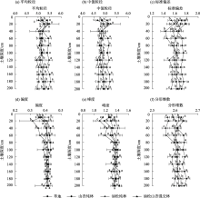
图2
不同植物群落土壤粒度参数"

表2
土壤分形维数与粒级含量相关性"
| 粒级 | 样地 | 回归方程 | R2 | P |
|---|---|---|---|---|
| 黏粒 | 草地 | y=0.0231x+2.4906 | 0.999 | 0.00 |
| 山杏纯林 | y=0.0288x+2.4571 | 0.986 | 0.00 | |
| 油松纯林 | y=0.0299x+2.4524 | 0.977 | 0.00 | |
| 油松山杏混交林 | y=0.0289x+2.4569 | 0.989 | 0.00 | |
| 粉粒 | 草地 | y=0.0044x+2.3312 | 0.842 | 0.00 |
| 山杏纯林 | y=0.0011x+2.5368 | 0.041 | 0.22 | |
| 油松纯林 | y=0.0029x+2.4239 | 0.756 | 0.00 | |
| 油松山杏纯林 | y=-0.0023x+2.7296 | 0.142 | 0.02 | |
| 砂粒 | 草地 | y=-0.0038x+2.7283 | 0.894 | 0.00 |
| 山杏纯林 | y=-0.0019x+2.6684 | 0.124 | 0.03 | |
| 油松纯林 | y=-0.0028x+2.6974 | 0.807 | 0.00 | |
| 油松山杏混交林 | y=0.0015x+2.5364 | 0.025 | 0.18 |
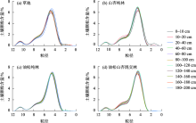
图3
不同植物群落土壤粒度频率分布曲线"

| [1] |
Mohammadi M H, Meskini-Vishkaee F. Predicting soil moisture characteristic curves from continuous particle-size distribution data[J]. Pedosphere, 2013, 23(1): 70-80.
doi: 10.1016/S1002-0160(12)60081-2 |
| [2] | Hu H C, Tian F Q, Hu H P. Soil particle size distribution and its relationship with soil water and salt under mulched drip irrigation in Xinjiang of China[J]. Science China Technology Sciences, 2011, 54: 1568-1574. |
| [3] |
Paz-Ferreiro J, Vázquez E V, Miranda J G V. Assessing soil particle-size distribution on experimental plots with similar texture under different management systems using multifractal parameters[J]. Geoderma, 2010, 160(1): 47-56.
doi: 10.1016/j.geoderma.2010.02.002 |
| [4] | 曾全超, 李娅芸, 刘雷, 等. 黄土高原草地植被土壤团聚体特征与可蚀性分析[J]. 草地学报, 2014, 22(4): 743-749. |
| [ Zeng Quanchao, Li Yayun, Liu Lei, et al. Study on soil aggreate stability and soil erodibility in the grassland vegetation of the Loess Plateau region[J]. Acta Agrestia Sinica, 2014, 22(4): 743-749. ] | |
| [5] | 王佩将, 戴全厚, 丁贵杰, 等. 退化喀斯特植被恢复过程中的土壤抗蚀性变化[J]. 土壤学报, 2014, 51(4): 806-815. |
| [ Wang Peijiang, Dai Quanhou, Ding Guijie, et al. Variation of soil anti-erodibility during restoration of degraded Karst vegetation[J]. Acta Pedologica Sinica, 2014, 51(4): 806-815. ] | |
| [6] |
Tyler S W, Wheatcraft S W. Fractal scaling of soil particle-size distributions: Analysis and limitations[J]. Soil Science Society of America Journal, 1992, 56(2): 362-369.
doi: 10.2136/sssaj1992.03615995005600020005x |
| [7] | 李宗善, 杨磊, 王国梁, 等. 黄土高原水土流失治理现状、问题及对策[J]. 生态学报, 2019, 39(20): 7398-7409. |
| [ Li Zongshan, Yang Lei, Wang Guoliang, et al. The management of soil and water conservation in the Loess Plateau of China: Present situations, problems, and counter-solutions[J]. Acta Ecologica Sinica, 2019, 39(20): 7398-7409. ] | |
| [8] |
Hua F, Wang X, Zheng X, et al. Opportunities for biodiversity gains under the world’s largest reforestation program[J]. Nature Communication, 2016, 7: 12717, doi: 10.1038/ncomms12717.
doi: 10.1038/ncomms12717 |
| [9] | 彭文英, 张科利, 陈瑶, 等. 黄土坡耕地退耕还林后土壤性质变化研究[J]. 自然资源学报, 2005, 20(2): 272-278. |
| [ Peng Wenying, Zhang Keli, Chen Yao, et al. Research on soil quality change after returning farmland to forest on Loess loping croplands[J]. Journal of Natural Resources, 2005, 20(2): 272-278. ] | |
| [10] | 黄艳丽, 李占斌, 苏辉, 等. 黄土高原不同生态治理小流域土壤有机质、容重及黏粒含量的对比[J]. 应用生态报, 2019, 30(2): 370-378. |
| [ Huang Yanli, Li Zhanbin, Su Hui, et al. Comparison of soil organic matter, bulk density and clay content in small watersheds under different ecological managements of Loess Plateau, China[J]. Journal of Applied Ecology, 2019, 30(2): 370-378. ] | |
| [11] | 杨灿, 魏天兴, 李亦然, 等. 黄土高原典型县域植被覆盖度时空变化及地形分异特征[J]. 生态学杂志, 2021, 40(6): 1830-1838. |
| [ Yang Can, Wei Tianxing, Li Yiran, et al. Temporal and spatial variations of fractional vegetation cover and topographic differentiation characteristics in typical counties of Loess Plateau[J]. Chinese Journal of Ecology, 2021, 40(6): 1830-1838. ] | |
| [12] |
Yu H W, Brandt M, Zhao M F, et al. Do afforestation projects increase core forests? Evidence from the Chinese Loess Plateau[J]. Ecological Indicators, 2020, 117: 106558, doi: 10.1016/j.ecolind.2020.106558.
doi: 10.1016/j.ecolind.2020.106558 |
| [13] | 刘增文, 段而军, 刘卓玛姐, 等. 黄土高原半干旱丘陵区不同树种纯林土壤性质极化研究[J]. 土壤学报, 2009, 46(6): 1110-1120. |
| [ Liu Zengwen, Duan Erjun, Liu Zhuomajie, et al. Soil polarization under pure stands of different tree varieties in semi-arid hilly areas of the Loess Plateau[J]. Acta Pedological Sinica, 2009, 46(6): 1110-1120. ] | |
| [14] | 李浩, 胡婵娟, 冯德显, 等. 半干旱黄土丘陵区退化人工林群落结构调整下细根特征分析[J]. 干旱区地理, 2020, 43(6): 1523-1533. |
| [ Li Hao, Hu Chanjuan, Feng Dexian, et al. Fine root characteristics of degraded artificial forest under community structure adjustment in semiarid loess hilly region[J]. Arid Land Geography, 2020, 43(6): 1523-1533. ] | |
| [15] | 刘青柏, 刘明国, 王玉涛, 等. 不同林型立地土壤水分性状及其持水能力的比较[J]. 干旱区研究, 2011, 28(5): 775-779. |
| [ Liu Qingbo, Liu Mingguo, Wang Yutao, et al. Comparison of soil water properties and soil water storage capacity in different forest habitats[J]. Arid Zone Research, 2011, 28(5): 775-779. ] | |
| [16] | 信忠保, 许炯心, 余新晓. 近50年黄土高原水土流失的时空变化[J]. 生态学报, 2009, 29(3): 1129-1139. |
| [ Xin Zhongbao, Xu Jiongxin, Yu Xinxiao. Temporal and spatial variability of sediment yield on the Loess Plateau in the past 50 years[J]. Acta Ecologica Sinica, 2009, 29(3): 1129-1139. ] | |
| [17] |
Qiao J B, Zhu Y J, Jia X X, et al. Multifractal characteristics of particle size distributions (50-200 m) in soils in the vadose zone on the Loess Plateau, China[J]. Soil and Tillage Research, 2021, 205: 104786, doi: 10.1016/j.still.2020.104786.
doi: 10.1016/j.still.2020.104786 |
| [18] | 李婷, 邓强, 袁志友, 等. 黄土高原纬度梯度上的植物与土壤碳、氮、磷化学计量学特征[J]. 环境科学, 2015, 36(8): 2988-2996. |
| [ Li Ting, Deng Qiang, Yuan Zhiyou, et al. Latitudinal changes in plant stoichiometric and soil C, N, P stoichiometry in Loess Plateau[J]. Environmental Science, 2015, 36(8): 2988-2996. ] | |
| [19] | 胡雅, 张露, 刘金宝. 黄土丘陵沟壑区沟道土壤养分分布特征研究[J]. 灌溉排水学报, 2018, 37(增刊2): 85-88. |
| [ Hu Ya, Zhang Lu, Liu Jinbao. Distribution characteristics of soil nutrients in loess hilly and gully area[J]. Journal of Irrigation and Drainage, 2018, 37(Suppl. 2): 85-88. ] | |
| [20] |
Martin W, Livia U, Eleanor H, et al. Soil organic carbon storage as a key function of soils: A review of drivers and indicators at various scales[J]. Geoderma, 2019, 333: 149-162.
doi: 10.1016/j.geoderma.2018.07.026 |
| [21] | 许智超, 张岩, 朱清科, 等. 半干旱黄土区退耕还林十年植被恢复变化分析--以陕西吴起县为例[J]. 生态环境学报, 2011, 20(1): 91-96. |
| [ Xu Zhichao, Zhang Yan, Zhu Qingke, et al. Vegetation restoration since the project of returning cropland to forest in the semiarid Loess Plateau: A case study of Wuqi County, Shaanxi Province[J]. Ecology and Environment, 2011, 20(1): 91-96. ] | |
| [22] |
Chen Y X, Wei T X, Sha G L, et al. Soil enzyme activities of typical plant communities after vegetation restoration on the Loess Plateau, China[J]. Applied Soil Ecology, 2022, 170: 104292, doi: 10.1016/j.apsoil.2021.104292.
doi: 10.1016/j.apsoil.2021.104292 |
| [23] | 高广磊, 丁国栋, 赵媛媛, 等. 四种粒径分级制度对土壤体积分形维数测定的影响[J]. 应用基础与工程科学学报, 2014, 22(6): 1060-1068. |
| [ Gao Guanglei, Ding Guodong, Zhao Yuanyuan, et al. Effects of soil particle size classification system on calculating volume-based fractal dimension[J]. Journal of Basic Science and Engingeering, 2014, 22(6): 1060-1068. ] | |
| [24] | 张佳瑞, 王金满, 祝宇成, 等. 分形理论在土壤学应用中的研究进展[J]. 土壤通报, 2017, 48(1): 221-228. |
| [ Zhang Jiarui, Wang Jinman, Zhu Yucheng, et al. Application of fractal theory on pedology: A review[J]. Chinese Journal of Soil Science, 2017, 48(1): 221-228. ] | |
| [25] | 王德, 傅伯杰, 陈利顶, 等. 不同土地利用类型下土壤粒径分形分析--以黄土丘陵沟壑区为例[J]. 生态学报, 2007, 27(7): 3081-3089. |
| [ Wang De, Fu Bojie, Chen Liding, et al. Fractal analysis on soil particle size distributions under different land-use types: A case study in the loess hilly areas of the Loess Plateau, China[J]. Acta Ecologica Sinica, 2007, 27(7): 3081-3089. ] | |
| [26] | 杨培岭, 罗远培, 石元春. 用粒径的重量分布表征的土壤分形特征[J]. 科学通报, 1993, 38(20): 1896-1899. |
| [ Yang Peiling, Luo Yuanpei, Shi Yuanchun. Fractal characteristics of soil characterized by weight distribution of particle size[J]. Chinese Science Bulletin, 1993, 38(20): 1896-1899. ] | |
| [27] | 卢连战, 史正涛. 沉积物粒度参数内涵及计算方法的解析[J]. 环境科学与管理, 2010, 35(6): 54-60. |
| [ Lu Lianzhan, Shi Zhengtao. Analysis for sediment grain size parameters of connotation sand calculation method[J]. Environmental Science and Management, 2010, 35(6): 54-60. ] | |
| [28] | 黄昌勇, 徐建明. 土壤学[M]. 第三版. 北京: 中国农业出版社, 1957: 108-115. |
| [ Huang Changyong, Xu Jianming. Soil science[M]. 3rd ed. Beijing: China Agricultural Press, 1957: 108-115. ] | |
| [29] | 袁杰, 曹生奎, 曹广超, 等. 祁连山南坡不同植被类型土壤粒度特征[J]. 水土保持通报, 2019, 39(2): 76-82. |
| [ Yuan Jie, Cao Shengkui, Cao Guangchao, et al. Soil particle size characteristics under different vegetation types on southern slope of Qilian Mountains[J]. Bulletin of Soil and Water Conservation, 2019, 39(2): 76-82. ] | |
| [30] |
脱登峰, 许明祥, 郑世清, 等. 黄土高原风蚀水蚀交错区侵蚀产沙过程及机理[J]. 应用生态学报, 2012, 23(12): 3281-3287.
pmid: 23479867 |
|
[ Tuo Dengfeng, Xu Mingxiang, Zheng Shiqing, et al. Sediment-yielding process and its mechanisms of slope erosion in wind-water erosion crisscross region of Loess Plateau, northwest China[J]. Chinese Journal of Applied Ecology, 2012, 23(12): 3281-3287. ]
pmid: 23479867 |
|
| [31] |
Xia Y, Zhou W J, Chen Y P, et al. Spatial variation of soil properties and carbon under different land use types on the Chinese Loess Plateau[J]. Science of the Total Environment, 2020, 703: 134946, doi: 10.1016/j.scitotenv.2019.134946.
doi: 10.1016/j.scitotenv.2019.134946 |
| [32] | 唐骏, 党廷辉, 薛江, 等. 植被恢复对黄土区煤矿排土场土壤团聚体特征的影响[J]. 生态学报, 2016, 36(16): 5067-5077. |
| [ Tang Jun, Dang Tinghui, Xue Jiang, et al. Effects of vegetation restoration on soil aggregate characteristics of an opencast coal mine dump in the loess area[J]. Acta Ecologica Sinica, 2016, 36(16): 5067-5077. ] | |
| [33] | 李程程, 曾全超, 贾培龙, 等. 黄土高原土壤团聚体稳定性及抗蚀性能力经度变化特征[J]. 生态学报, 2020, 40(6): 2039-2048. |
| [ Li Chengcheng, Zeng Quanchao, Jia Peilong, et al. Characteristics of soil aggregate stability and corrosion resistance longitude change in the Loess Plateau[J]. Acta Ecologica Sinica, 2020, 40(6): 2039-2048. ] | |
| [34] | 李少华, 王学全, 包岩峰, 等. 不同类型植被对高寒沙区土壤改良效果的差异分析[J]. 土壤通报, 2016, 47(1): 60-64. |
| [ Li Shaohua, Wang Xuequan, Bao Yanfeng, et al. Variability of soil properties under different vegetation plots in alpine sandy land[J]. Chinese Journal of Soil Science, 2016, 47(1): 60-64. ] | |
| [35] | 张雷一, 张静茹, 刘方, 等. 林草复合系统的生态效益[J]. 草业科学, 2014, 31(9): 1789-1797. |
| [ Zhang Leiyi, Zhang Jingru, Liu Fang, et al. A review of ecological benefits of silvopasture systems[J]. Pratacultural Science, 2014, 31(9): 1789-1797. ] | |
| [36] |
Fan Y, Miguez-Macho G, Jackson R, et al. Hydrologic regulation of plant rooting depth[J]. Proceedings of the National Academy of Sciences of the United States, 2017, 114(40): 10572-10577.
doi: 10.1073/pnas.1712381114 |
| [37] |
Lü M K, Noormets A, Ukonmaanaho L, et al. Stability of soil organic carbon during forest conversion is more sensitive in deep soil than in topsoil in subtropical forests[J]. Pedobiologia, 2021, 84: 105716, doi: 10.1016/j.pedobi.2020.150706.
doi: 10.1016/j.pedobi.2020.150706 |
| [38] | 陈宇轩, 高广磊, 张英, 等. 呼伦贝尔沙地风沙土粒径分布特征[J]. 北京林业大学学报, 2019, 41(8): 124-130. |
| [ Chen Yuxuan, Gao Guanglei, Zhang Ying, et al. Particle size distribution of aeolian soils in Hulun Buir Sandy Land, Inner Mongolia of northern China[J]. Journal of Beijing Forestry University, 2019, 41(8): 124-130. ] | |
| [39] | 张立恒, 李清雪, 王学全, 等. 高寒沙地中间锦鸡儿人工林根系分布及林下土壤特性研究[J]. 土壤通报, 2019, 50(4): 840-846. |
| [ Zhang Liheng, Li Qingxue, Wang Xuequan, et al. Root distribution and soil properties under Caragana intermedia plantations in alpine sandy land[J]. Chinese Journal of Soil Science, 2019, 50(4): 840-846. ] | |
| [40] |
Wang J, Zhao W W, Wang G, et al. Effects of long-term afforestation and natural grassland recovery on soil properties and quality in Loess Plateau (China)[J]. Science of the Total Environment, 2021, 770: 144833, doi: 10.1016/j.scitotenv.2020.144833.
doi: 10.1016/j.scitotenv.2020.144833 |
| [41] | 王雅琼, 张建军, 李梁, 等. 祁连山区典型草地生态系统土壤抗冲性影响因子[J]. 生态学报, 2018, 38(1): 122-131. |
| [ Wang Yaqiong, Zhang Jianjun, Li Liang, et al. Analysis of factors impacting soil anti-scourability of typical grassland ecosystems on the Qilian Mountains[J]. Acta Ecologica Sinica, 2018, 38(1): 122-131. ] | |
| [42] | 赵忠, 李鹏. 渭北黄土高原主要造林树种根系分布特征及抗旱性研究[J]. 水土保持学报, 2002, 16(1): 96-99, 107. |
| [ Zhao Zhong, Li Peng. Researches on vertical root distributions and drought resistance of main planting tree species in Weibei Loess Plateau[J]. Journal of Soil and Water Conservation, 2002, 16(1): 96-99, 107. ] | |
| [43] | 陈宇轩, 张飞岳, 高广磊, 等. 科尔沁沙地樟子松人工林土壤粒径分布特征[J]. 干旱区地理, 2020, 43(4): 1051-1058. |
| [ Chen Yuxuan, Zhang Feiyue, Gao Guanglei, et al. Soil particle size distribution of Pinus sylvestris var. mongolica plantations in the Horqin Sandy Land[J]. Arid Land Geography, 2020, 43(4): 1051-1058. ] | |
| [44] | 刘小娥, 苏世平, 李毅, 等. 黄土高原地区人工林营造-混交林模式生态效益研究[J]. 干旱区研究, 2021, 38(2): 380-391. |
| [ Liu Xiao’e, Su Shiping, Li Yi, et al. Study on the ecological benefits of a plantation mixed forest model in the Loess Plateau[J]. Arid Zone Research, 2021, 38(2): 380-391. ] | |
| [45] | 刘欣, 彭道黎, 邱新彩. 华北落叶松不同林型土壤理化性质差异[J]. 应用与环境生物学报, 2018, 24(4): 735-743. |
| [ Liu Xin, Peng Daoli, Qiu Xincai. Differences in soil physicochemical properties between different forest types of Larix principis-rupprechtii[J]. Journal of Applied Environmental Biology, 2018, 24(4): 735-743. ] | |
| [46] | 杜满义, 张连金, 裴顺祥, 等. 不同类型油松混交林土壤物理特性[J]. 生态学杂志, 2020, 39(11): 3588-3595. |
| [ Du Manyi, Zhang Lianjin, Pei Shunxiang, et al. Soil physical characteristics in different types of Pinus tabuliformis mixed forest[J]. Chinese Journal of Ecology, 2020, 39(11): 3588-3595. ] | |
| [47] | 刘绍辉, 方精云. 土壤呼吸的影响因素及全球尺度下温度的影响[J]. 生态学报, 1997, 17(5): 19-26. |
| [ Liu Shaohui, Fang Jingyun. Effect factors of soil respiration and the temperature’s effects on soil respiration in the global scale[J]. Acta Ecologica Sinica, 1997, 17(5): 19-26. ] | |
| [48] |
Zhao C L, Shao M A, Jia X X, et al. Particle size distribution of soils (0-500 cm) in the Loess Plateau, China[J]. Geoderma Regional, 2016, 7(3): 251-258.
doi: 10.1016/j.geodrs.2016.05.003 |
| [49] | 孙佳佳, 王培, 王志刚, 等. 不同成土母质及土地利用对红壤机械组成的影响[J]. 长江科学院院报, 2015, 32(3): 54-58. |
| [ Sun Jiajia, Wang Pei, Wang Zhigang, et al. Impact of parent material and land use type on mechanical composition of red soil[J]. Journal of Yangtze River Scientific Research Institute, 2015, 32(3): 54-58. ] | |
| [50] | 吕国华, 李小强, 白文波, 等. 半湿润与半干旱区黄绵土冬小麦农田土壤剖面特征研究[J]. 土壤通报, 2019, 50(5): 1033-1037. |
| [ Lü Guohua, Li Xiaoqiang, Bai Wenbo, et al. Loessal soil profile properties of winter wheat field in semi-humid and semi-arid zones[J]. Chinese Journal of Soil Science, 2019, 50(5): 1033-1037. ] | |
| [51] | 宋洁, 春喜, 白雪梅, 等. 中国沙漠粒度分析研究综述[J]. 中国沙漠, 2016, 36(3): 597-603. |
| [ Song Jie, Chun Xi, Bai Xuemei, et al. Review of grain size analysis in China desert[J]. Journal of Desert Research, 2016, 36(3): 597-603. ] | |
| [52] | 董莉丽, 马孝燕, 胡丹, 等. 吴起县退耕还林样地土壤粒径分布的单一和多重分形特征[J]. 干旱区资源与环境, 2015, 29(7): 111-115. |
| [ Dong Lili, Ma Xiaoyan, Hu Dan, et al. Monofractal and multifractal characteristics of soil particle size distribution in sample sites of grain for green in Wuqi County[J]. Journal of Arid Land Resources and Environment, 2015, 29(7): 111-115. ] | |
| [53] | 赵明月, 赵文武, 刘源鑫. 不同尺度下土壤粒径分布特征及其影响因子--以黄土丘陵沟壑区为例[J]. 生态学报, 2015, 35(14): 4625-4632. |
| [ Zhao Mingyue, Zhao Wenwu, Liu Yuanxin. Comparative analysis of soil particle size distribution and its influence factors in different scales: A case study in the loess hilly-gully area[J]. Acta Ecologica Sinica, 2015, 35(14): 4625-4632. ] | |
| [54] | 郭琦, 王新杰. 不同混交模式杉木人工林林下植被生物量与土壤物理性质研究[J]. 中南林业科技大学学报, 2014, 34(5): 70-74. |
| [ Guo Qi, Wang Xinjie. Undergrowth biomass and soil physical properties under Cunninghamia lanceolata with different patterns of mixed forests[J]. Journal of Central South University of Forestry Technology, 2014, 34(5): 70-74. ] | |
| [55] | 谢育利, 陈云明, 唐亚坤, 等. 地表凋落物对油松、沙棘人工林土壤呼吸的影响[J]. 水土保持研究, 2017, 24(6): 52-61. |
| [ Xie Yuli, Chen Yunming, Tang Yakun, et al. Impact of aboveground litterfall on soil respiration in the Pinus tabulaeformis and Hippophae rhamnoides plantations[J]. Research of Soil and Water Conservation, 2017, 24(6): 52-61. ] | |
| [56] | 童春元, 李钢铁, 卢立娜, 等. 杨树低效林下土壤粒径分布与分形特征[J]. 水土保持通报, 2019, 39(5): 308-315. |
| [ Tong Chunyuan, Li Gangtie, Lu Lina, et al. Distribution of soil size and fractal characteristics under low-efficiency poplar forests[J]. Bulletin of Soil and Water Conservation, 2019, 39(5): 308-315. ] | |
| [57] | 邱捷, 王洪德, 郑一鹏, 等. 海涂围垦区不同土地利用类型土壤颗粒分形特征[J]. 农业现代化研究, 2020, 41(5): 882-888. |
| [ Qiu Jie, Wang Hongde, Zheng Yipeng, et al. Fractal features of soil particles under different land uses in a coastal reclamation area[J]. Research of Agricultural Modernization, 2020, 41(5): 882-888. ] | |
| [58] | 魏晨辉, 沈光, 裴忠雪, 等. 不同植物种植对松嫩平原盐碱地土壤理化性质与细根生长的影响[J]. 植物研究, 2015, 35(5): 759-764. |
| [ Wei Chenhui, Shen Guang, Pei Zhongxue, et al. Effects of different plants cultivation on soil physical-chemical properties and fine root growth in saline-alkaline soil in Songnen Plain, northeastern China[J]. Bulletin of Botanical Research, 2015, 35(5): 759-764. ] |
| [1] | 任涛涛,李双双,段克勤,何锦屏. 黄土高原热浪型和缺水型骤旱时空变化特征及其影响因素[J]. 干旱区地理, 2023, 46(3): 360-370. |
| [2] | 安彬,肖薇薇,刘宇峰,刘全玉. 1955—2021年黄土高原地区相对湿度时空演变规律[J]. 干旱区地理, 2023, 46(12): 1939-1950. |
| [3] | 卓静,胡皓,何慧娟,王智,杨承睿. 陕北黄土高原生态脆弱性时空变异及驱动因素分析[J]. 干旱区地理, 2023, 46(11): 1768-1777. |
| [4] | 钱伟, 王春, 代文, 卢旺达, 李敏, 陶宇, 李梦琪. 基于深度学习融合OBIA的黄土高原小流域淤地坝系提取[J]. 干旱区地理, 2023, 46(11): 1803-1812. |
| [5] | 叶文丽,杨新军,吴孔森,王银. 黄土高原社会-生态系统恢复力时空变化特征与影响因素分析[J]. 干旱区地理, 2022, 45(3): 912-924. |
| [6] | 吉珍霞,侯青青,裴婷婷,陈英,谢保鹏,吴华武. 黄土高原植被物候对季节性干旱的敏感性响应[J]. 干旱区地理, 2022, 45(2): 557-565. |
| [7] | 孙健武,高军波,马志飞,喻超,张欣怡. 不同地理环境下“空间贫困陷阱”分异机制比较——基于大别山与黄土高原的实证[J]. 干旱区地理, 2022, 45(2): 650-659. |
| [8] | 梁晓磊,翟晓慧,牛清河,胡子豪,王天虎,刘万成. 敦煌雅丹地层沉积物粒度特征初步研究[J]. 干旱区地理, 2022, 45(1): 141-152. |
| [9] | 娄泊远,王永东,周娜,闫晋升,艾柯代·艾斯凯尔. 努尔苏丹樟子松人工林土壤粒度组成特征研究[J]. 干旱区地理, 2022, 45(1): 219-225. |
| [10] | 田达睿,唐皓,谭静斌. 陕北黄土高原丘陵沟壑区聚落适宜空间模式研究——以米脂县东沟为例[J]. 干旱区地理, 2022, 45(1): 263-276. |
| [11] | 牛燕宁,綦琳,乔彦松. 基于碎屑锆石年代学对黄土高原物源及其时空差异的理解与展望[J]. 干旱区地理, 2021, 44(6): 1623-1634. |
| [12] | 姜丽,魏天兴,李亦然,魏安琪. 地形因子对陕北黄土丘陵区防护林树种分布的影响[J]. 干旱区地理, 2021, 44(6): 1763-1771. |
| [13] | 安彬,肖薇薇,张淑兰,朱妮,张建东. 1960—2017年黄土高原地表温度时空变化特征[J]. 干旱区地理, 2021, 44(3): 778-785. |
| [14] | 王钧,李广,聂志刚,董莉霞,闫丽娟. 陇中黄土高原区旱地春小麦产量对干旱胁迫响应的模拟研究[J]. 干旱区地理, 2021, 44(2): 494-506. |
| [15] | 姚雪玲,杨国靖,王帅,郭秀江. 黄土丘陵沟壑区不同深度土壤水分对降雨的响应及其稳定性[J]. 干旱区地理, 2021, 44(2): 507-513. |
|
||