| [3] |
王旋旋, 陈亚宁, 李稚, 等. 基于模糊综合评价模型的中亚水资源开发潜力评估[J]. 干旱区地理, 2020, 43(1): 127-134.
|
|
[Wang Xuanxuan, Chen Yaning, Li Zhi, et al. Assessment of the development potential of water resources in Central Asia based on fuzzy comprehensive evaluation model[J]. Arid Land Geography, 2020, 43(1): 127-134.]
|
| [4] |
陈亚宁, 李稚, 方功焕, 等. 气候变化对中亚天山山区水资源影响研究[J]. 地理学报, 2017, 72(1): 18-26.
doi: 10.11821/dlxb201701002
|
|
[Chen Yaning, Li Zhi, Fang Gonghuan, et al. Impact of climate change on water resources in the Tianshan Mountains, Central Asia[J]. Acta Geographica Sinica, 2017, 72(1): 18-26.]
doi: 10.11821/dlxb201701002
|
| [5] |
张凯, 韩永翔, 张勃, 等. 黑河中游水资源开发利用的阶段潜力研究[J]. 地理科学, 2006, 26(2): 179-185.
|
|
[Zhang Kai, Han Yongxiang, Zhang Bo, et al. Stage potential of development and utilization for water resources in the middle reaches of the Heihe River[J]. Scientia Geographnica Sinica, 2006, 26(2): 179-185.]
|
| [6] |
Gao C, Hao M Q, Song L H, et al. Comparative study on the calculation methods of ecological base flow in a mountainous river[J]. Frontiers in Environmental Science, 2022, 10: 931844, doi: 10.3389/fenvs.2022.931844.
|
| [7] |
郭巧玲, 杨琳洁, 李恩宽. 额济纳绿洲植被生态需水量空间分布[J]. 干旱区资源与环境, 2013, 27(8): 103-107.
|
|
[Guo Qiaoling, Yang Linjie, Li Enkuan. Spatial distribution of ecological water requirement for vegetations in Ejina oasis[J]. Journal of Arid Land Resources and Environment, 2013, 27(8): 103-107.]
|
| [8] |
Chen Y N, Li W H, Deng H J, et al. Changes in Central Asia’s water Tower: Past, present and future[J]. Scientific Reports, 2016, 6: 35458, doi: 10.1038/srep35458.
|
| [9] |
崔彩霞, 魏荣庆, 李杨. 塔里木河上游地区积雪长期变化趋势及其对径流量的影响[J]. 干旱区地理, 2005, 28(5): 569-573.
|
| [1] |
Arnell N W. Climate change and global water resources[J]. Global Environmental Change, 1999, 9: 31-49.
|
| [2] |
李丽, 刘诗奇, 王平, 等. 基于负载指数的中蒙俄经济走廊水资源开发潜力评价[J]. 干旱区研究, 2021, 38(4): 910-918.
|
|
[Li Li, Liu Shiqi, Wang Ping, et al. Evaluation of water resource exploration potential of the China-Mongolia-Russia Economic Corridor based on carrying capacity[J]. Arid Zone Research, 2021, 38(4): 910-918.]
|
| [9] |
[Cui Caixia, Wei Rongqing, Li Yang. Long-term change of seasonal snowcover and its effects on runoff volume in the upper reaches of the Tarim River[J]. Arid Land Geography, 2005, 28(5): 569-573.]
|
| [10] |
Fan Y T, Chen Y N, He Q, et al. Isotopic characterization of river waters and water source identification in an inland river, Central Asia[J]. Water, 2016, 8(7): 286, doi: 10.3390/w8070286.
|
| [11] |
Dong W H, Lin Y L, Wright S J, et al. Regional disparities in warm season rainfall changes over arid eastern-Central Asia[J]. Scientific Reports, 2018, 8: 13051, doi: 10.1038/s41598-018-31246-3.
pmid: 30158578
|
| [12] |
陈亚宁, 李稚, 范玉婷, 等. 西北干旱区气候变化对水文水资源影响研究进展[J]. 地理学报, 2014, 69(9): 1-10.
|
|
[Chen Yaning, Li Zhi, Fan Yuting, et al. Research progress on the impact of climate change on water resources in the arid region of northwest China[J]. Acta Geographica Sinica, 2014, 69(9): 1-10.]
|
| [13] |
Fang G H, Li Z, Chen Y N, et al. Projecting the impact of climate change on runoff in the Tarim River simulated by the soil and water assessment tool glacier model[J]. Remote Sensing, 2023, 15 (16): 3922, doi: 10.3390/rs15163922.
|
| [14] |
Gao X Y, Fang G H, Chen Y N, et al. Analysis of runoff variations in an arid catchment based on multi-model ensemble: A case study in the Tarim River Basin in Central Asia[J]. Frontiers in Earth science, 2023, 11: 1249107, doi: 10.3389/feart.2023.1249107.
|
| [15] |
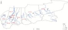
黄星, 陈伏龙, 赵琪, 等. 新疆和田河径流丰枯评价及组合分析[J]. 干旱区研究, 2021, 38(6): 1570-1578.
|
|
[Huang Xing, Chen Fulong, Zhao Qi, et al. Evaluation and combination analysis of runoff in Hotan River, Xinjiang[J]. Arid Zone Research, 2021, 38(6): 1570-1578.]
|
 ), YANG Yuhai, ZHU Chenggang(