干旱区地理 ›› 2026, Vol. 49 ›› Issue (3): 581-593.doi: 10.12118/j.issn.1000-6060.2025.297 cstr: 32274.14.ALG2025297
杨嘉晖1,2,3( ), 刘晓煌2,3,4(), 时鹏1, 李鹏1, 刘润2,3,4, 祝萍2,3,4, 马敏2,3,4, 吴广杰2,3,4
收稿日期:2025-05-27
修回日期:2025-08-17
出版日期:2026-03-25
发布日期:2026-03-24
通讯作者:
刘晓煌(1972-),男,博士,正高级工程师,主要从事自然资源和地球系统科学研究. E-mail: liuxh19972004@163.com作者简介:杨嘉晖(2001-),男,硕士研究生,主要从事自然资源和地球系统科学研究. E-mail: yjh20011215@163.com
基金资助:
YANG Jiahui1,2,3(), LIU Xiaohuang2,3,4(), SHI Peng1, LI Peng1, LIU Run2,3,4, ZHU Ping2,3,4, MA Min2,3,4, WU Guangjie2,3,4
Received:2025-05-27
Revised:2025-08-17
Published:2026-03-25
Online:2026-03-24
摘要:
新疆额尔齐斯河流域“生产-生活-生态”(“三生”)空间规划调控研究具有重要理论与实践价值。通过构建空间格网与行政区双尺度评价指标体系,揭示2000—2023年额尔齐斯河流域“三生”用地时空演变规律,诊断“三生”空间耦合协调度,并基于FLUS模型提出其空间优化调控路径。结果表明:(1)2000—2023年额尔齐斯河流域生产与生活空间分别扩张1199 km2和94 km2,生态空间缩减1319 km2,农业生产空间侵占草地、林地生态空间和城镇生活空间扩张导致生态退化。(2)生产空间高适宜区集中于城镇周边,低适宜区受限于戈壁沙地等未利用地;生活空间适宜性随城镇化提升,但未利用地的适宜性仍较低;生态空间呈现“山区优化、平原退化”的二元特征。(3)2000—2023年“三生”空间轻微失调格网数出现增加,主要分布在富蕴县和吉木乃县。濒临失调地区格网数出现减少,主要分布在布尔津县和哈巴河县。基本协调和良好协调地区格网数出现了大幅增加,主要分布在哈巴河县、阿勒泰市、福海县和北屯市。(4)额尔齐斯河流域国土空间功能提升应该在保证粮食产量的基础上以生态保护为导向,把部分生态适宜而生产不适宜的区域退耕还草,提升区域生态系统的整体服务功能。
杨嘉晖, 刘晓煌, 时鹏, 李鹏, 刘润, 祝萍, 马敏, 吴广杰. “三生”功能视角下额尔齐斯河流域空间优化调控研究[J]. 干旱区地理, 2026, 49(3): 581-593.
YANG Jiahui, LIU Xiaohuang, SHI Peng, LI Peng, LIU Run, ZHU Ping, MA Min, WU Guangjie. Spatial optimization and regulation in the Irtysh River Basin from the perspective of production-living-ecological function[J]. Arid Land Geography, 2026, 49(3): 581-593.

图1
研究区概况"
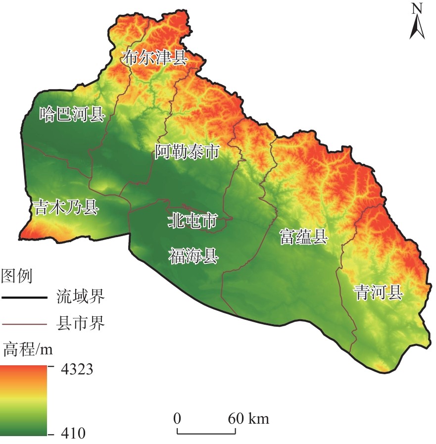
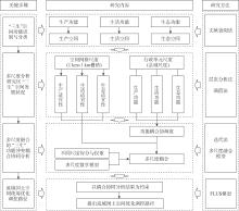
图2
研究框架"

表1
“三生”空间分类体系"
| 空间类型 | 一级分类 | 二级分类 |
|---|---|---|
| 生产空间 | 农业生产空间 | 旱地、高覆盖度草地、中覆盖度草地 |
| 工业生产空间 | 其他建设用地 | |
| 生活空间 | 城镇生活空间 | 城镇用地 |
| 农村生活空间 | 农村居民点 | |
| 生态空间 | 林地生态空间 | 有林地、灌木林地、其他林地 |
| 草地生态空间 | 低覆盖度草地 | |
| 水域生态空间 | 河渠、湖泊、水库坑塘、滩地 | |
| 其他生态空间 | 永久性冰川雪地、沙地、戈壁、盐碱地、沼泽地、裸土地、裸岩石质地、其他未利用地 |
表2
“三生”空间适宜性评价指标体系"
| 空间类型 | 指标 | 权重 | 指标分级和打分 | ||||
|---|---|---|---|---|---|---|---|
| 5 | 4 | 3 | 2 | 1 | |||
| 生产空间 | 土地利用类型 | 0.2324 | 耕地 | 建设用地、中覆盖度 草地、高覆盖度草地 | 沟渠、林地、低覆 盖度草地 | 水库坑塘 | 其他 |
| 高程/m | 0.0877 | <800 | [800, 1200) | [1200, 1800) | [1800, 2400) | ≥2400 | |
| 坡度/(°) | 0.0877 | <4 | [4, 9) | [9, 15) | [15, 23) | ≥23 | |
| 年均气温/°C | 0.0505 | ≥4.8 | [1.7, 4.8) | [-2.0, 1.7) | [-5.5, -2.0) | <-5.5 | |
| 年均降雨量/mm | 0.0505 | ≥400 | [330, 400) | [250, 330) | [200, 250) | <200 | |
| 土壤有机质/g·kg-1 | 0.1540 | ≥27 | [19, 27) | [11, 19) | [3, 11) | <3 | |
| 土壤pH值 | 0.1540 | [6.5, 7.5) | [6.0, 6.5) | [7.5, 8.0) | [5.5, 6.0) | <5.5,≥8.0 | |
| 水系距离/m | 0.0747 | <500 | [500, 1500) | [1500, 3000) | [3000, 5000) | ≥5000 | |
| 道路距离/m | 0.1085 | <500 | [500, 1500) | [1500, 3000) | [3000, 5000) | ≥5000 | |
| 生活空间 | 土地利用类型 | 0.2738 | 城镇、农村 | 耕地、草地、沟渠 | 林地 | 建设用地 | 其他 |
| 高程/m | 0.0567 | <800 | [800, 1200) | [1200, 1800) | [1800, 2400) | ≥2400 | |
| 坡度/(°) | 0.0567 | <4 | [4, 9) | [9, 15) | [15, 23) | ≥23 | |
| 夜间灯光亮度 | 0.1134 | ≥28 | [18, 28) | [11, 18) | [4, 11) | <4 | |
| 经济密度/104元·km-2 | 0.1129 | ≥43 | [25, 43) | [14, 25) | [5, 14) | <5 | |
| 人口密度/人·km-2 | 0.1129 | ≥104 | [50, 104) | [26, 50) | [9, 26) | <9 | |
| 距居民点距离/m | 0.1369 | <1000 | [1000, 3000) | [3000, 5000) | [5000, 10000) | ≥10000 | |
| 距道路距离/m | 0.1369 | <500 | [500, 1500) | [1500, 3000) | [3000, 5000) | ≥5000 | |
| 生态空间 | 土地利用类型 | 0.2789 | 林地、草地 | 天然陆地水域 | 耕地、未利用地 | 水利设施用地 | 其他 |
| 高程/m | 0.0866 | ≥2400 | [1800, 2400) | [1200, 1800) | [800, 1200) | <800 | |
| 坡度/(°) | 0.0866 | >23 | [15, 23) | [9, 15) | [4, 9) | <4 | |
| 归一化植被指数 | 0.1883 | >0.72 | [0.55, 0.72) | [0.36, 0.55) | [0.20, 0.36) | <0.20 | |
| 距建设用地距离/m | 0.1546 | ≥5000 | [3000, 5000) | [1500, 3000) | [500, 1500) | <500 | |
| 距水系距离/m | 0.1113 | ≥8000 | [6000, 8000) | [4000, 6000) | [2000, 4000) | <2000 | |
| 景观破碎度 | 0.0937 | 规则性好 | 规则性较好 | 规则性一般 | 规则性较差 | 规则性差 | |
表3
“三生”空间功能可持续性评价指标体系"
| 一级功能 | 二级功能 | 指标 | 数据获取 | 权重 | ||
|---|---|---|---|---|---|---|
| 2000年 | 2010年 | 2023年 | ||||
| 生产功能 | 农业供给功能 | 耕地面积比重/% | 耕地面积/行政单元面积 | 0.098 | 0.104 | 0.107 |
| 粮食人均占有量/kg·人-1 | 粮食产量/总人口数 | 0.020 | 0.030 | 0.044 | ||
| 粮食产出率/kg·km-2 | 粮食产量/耕地面积 | 0.019 | 0.026 | 0.051 | ||
| 第一产业增加值/104元 | 第一产业增加值 | 0.029 | 0.031 | 0.039 | ||
| 非农业供给功能 | 第二产业增加值/104元 | 第二产业增加值 | 0.034 | 0.058 | 0.046 | |
| 工业企业平均产值/104元·个-1 | 工业企业总产值/工业企业数 | 0.030 | 0.076 | 0.086 | ||
| 土地产出率/104元·km-2 | 总产值/行政单元面积 | 0.114 | 0.101 | 0.131 | ||
| 生活功能 | 居住承载功能 | 生活用地比重/% | 生活用地面积/行政单元面积 | 0.116 | 0.125 | 0.138 |
| 人口密度/人·km-2 | 人口数/行政单元面积 | 0.013 | 0.014 | 0.015 | ||
| 人均医院床位/张·人-1 | 总床位数/总人口数 | 0.161 | 0.060 | 0.054 | ||
| 社会保障功能 | 路网通达性/km·km-2 | 道路长度/行政单元面积 | 0.052 | 0.054 | 0.058 | |
| 人均居民存款/104元·人-1 | 居民总存款/总人口数 | 0.174 | 0.142 | 0.067 | ||
| 城镇化水平/% | 城镇人口/总人口数 | 0.021 | 0.053 | 0.042 | ||
| 生态功能 | 生态维持功能 | 生态用地比重/% | 生态用地/行政单元面积 | 0.013 | 0.014 | 0.015 |
| 植被覆盖率/% | 林地面积/行政单元面积 | 0.023 | 0.024 | 0.027 | ||
| 水域覆盖率/% | 水域面积/行政单元面积 | 0.082 | 0.088 | 0.081 | ||

图3
2000—2023年额河流域“三生”空间分布"
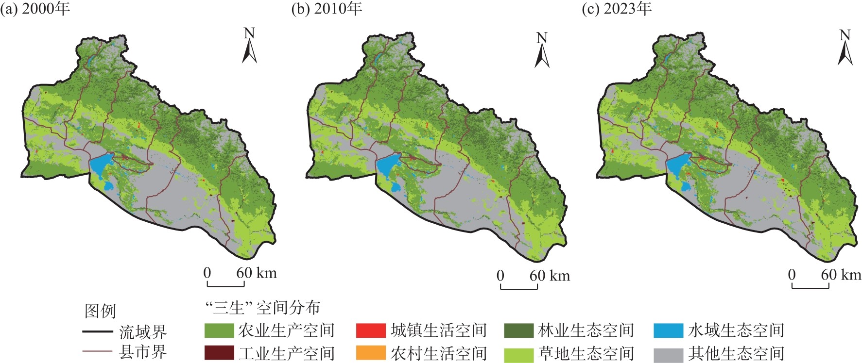
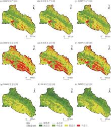
图4
2000—2023年额河流域“三生”空间适宜性评价 注:由于数据问题,部分边界上色块未和边界完全吻合。下同。"
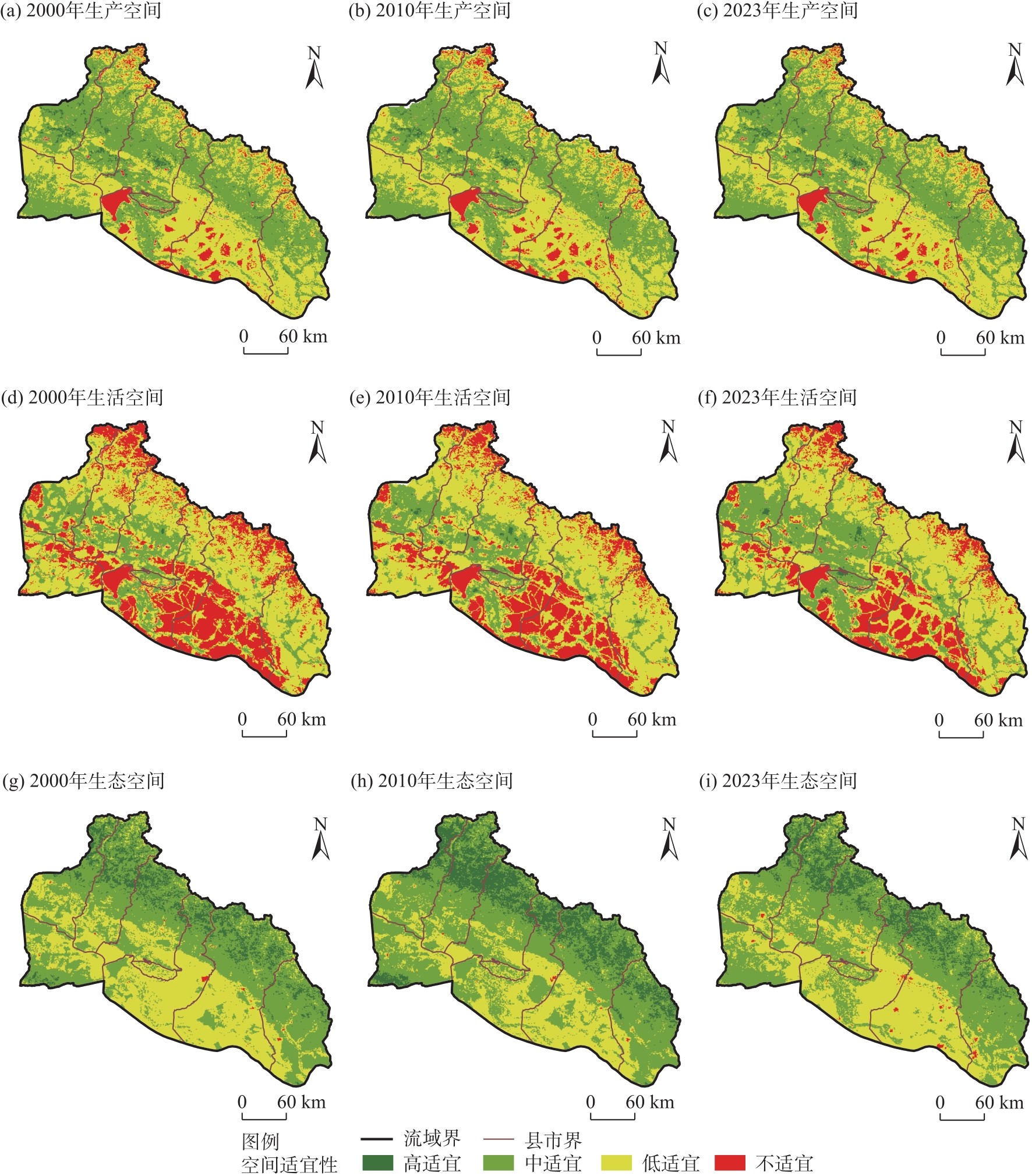
图5
2000—2023年额河流域“三生”空间功能可持续性评价"
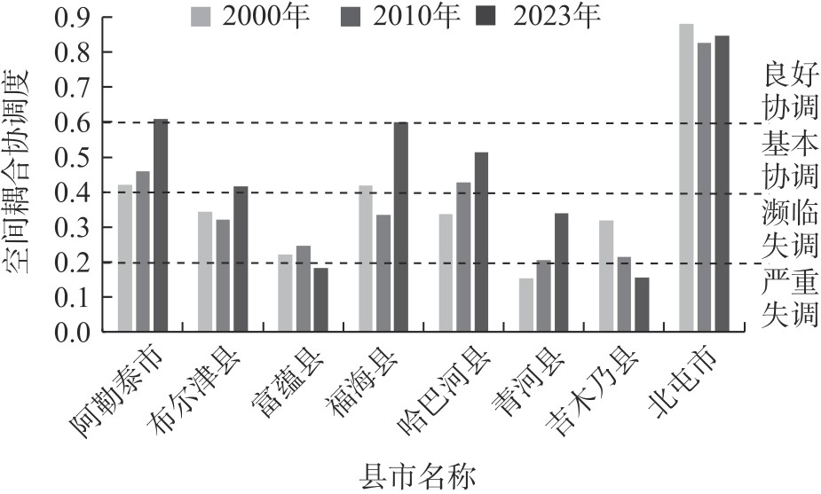
图6
2000—2023年额河流域多尺度“三生”功能冲突耦合协调评价结果"
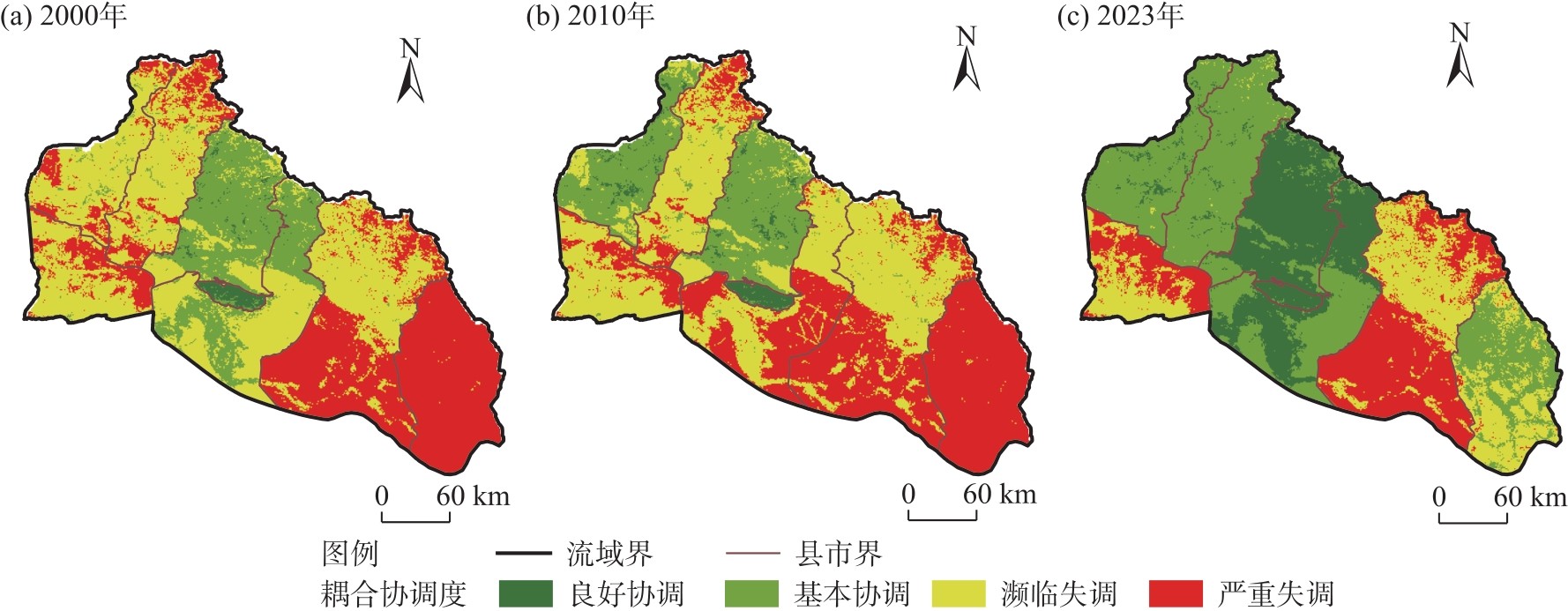

图7
2023年额河流域单尺度和多尺度的耦合协调结果对比"
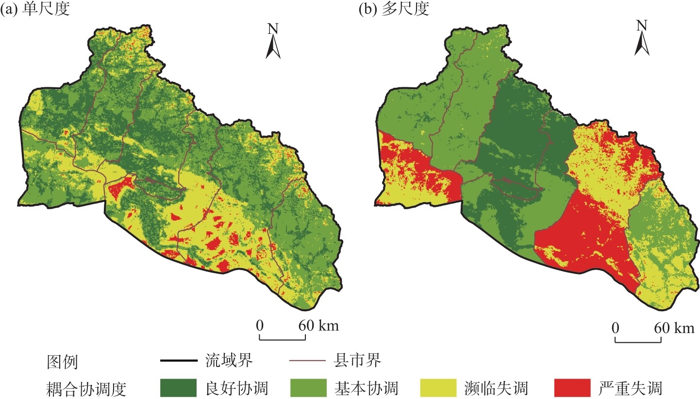
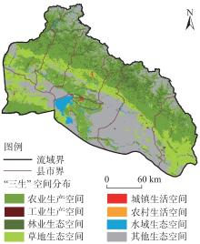
图8
2030年额河流域“三生”空间模拟优化结果"

| [1] |
李生宇, 雷加强. 额尔齐斯河流域生态系统格局及变化[J]. 干旱区研究, 2002, 19(2): 56-61.
doi: 10.13866/j.azr.2002.02.012 |
| [Li Shengyu, Lei Jiaqiang. The pattern and change of the ecosystems in the Ergis River Watershed[J]. Arid Zone Research, 2002, 19(2): 56-61.] | |
| [2] | 赵群英, 贺晓涛. 阿勒泰地区主要生态环境问题及对策建议[J]. 新疆有色金属, 2007, 30(3): 13-14. |
| [Zhao Qunying, He Xiaotao. Main ecological and environmental issues and countermeasures in Altay Prefecture[J]. Xinjiang Nonferrous Metals, 2007, 30(3): 13-14.] | |
| [3] | 康相武, 吴绍宏, 杨勤业, 等. 新疆阿勒泰地区的生态环境问题及解决对策[J]. 地理科学进展, 2004, 23(4): 19-27. |
| [Kang Xiangwu, Wu Shaohong, Yang Qinye, et al. Ecological environment problems and sustainable development strategy in Altay Prefecture, Xinjiang[J]. Progress in Geography, 2004, 23(4): 19-27.] | |
| [4] | 郑艺文, 刘晓煌, 熊茂秋, 等. 1990—2018年新疆“三生”用地时空变化特征及其碳排放效应[J]. 草业科学, 2022, 39(12): 2565-2577. |
| [Zheng Yiwen, Liu Xiaohuang, Xiong Maoqiu, et al. Spatial-temporal characteristics of ecological-living-productive land and its carbon emissions in Xinjiang from 1990 to 2018[J]. Pratacultural Science, 2022, 39(12): 2565-2577.] | |
| [5] | 徐洁, 谢高地, 肖玉, 等. 国家重点生态功能区生态环境质量变化动态分析[J]. 生态学报, 2019, 39(9): 3039-3050. |
| [Xu Jie, Xie Gaodi, Xiao Yu, et al. Dynamic analysis of ecological environmental quality changes in national key ecological function areas in China[J]. Acta Ecologica Sinica, 2019, 39(9): 3039-3050.] | |
| [6] |
江东, 林刚, 付晶莹, 等. “三生空间”统筹的科学基础与优化途径探析[J]. 自然资源学报, 2021, 36(5): 1085-1101.
doi: 10.31497/zrzyxb.20210501 |
|
[Jiang Dong, Lin Gang, Fu Jingying, et al. Discussion on scientific foundation and approach for the overall optimization of “production-living-ecological”space[J]. Journal of Natural Resources, 2021, 36(5): 1085-1101.]
doi: 10.31497/zrzyxb.20210501 |
|
| [7] |
牛雅萱, 吴世新, 郭晨宇, 等. 新疆县市“三生”功能时空变化及耦合协调性分析[J]. 干旱区地理, 2021, 44(6): 1821-1835.
doi: 10.12118/j.issn.1000–6060.2021.06.29 |
|
[Niu Yaxuan, Wu Shixin, Guo Chenyu, et al. Spatio-temporal changes and coupling coordination of the function of “production-living-ecological”in Xinjiang[J]. Arid Land Geography, 2021, 44(6): 1821-1835.]
doi: 10.12118/j.issn.1000–6060.2021.06.29 |
|
| [8] | 程雪丹, 渠丽萍, 王雄. 生态脆弱区“三生空间”土地利用转型特征——以青海省大通县为例[J]. 中南农业科技, 2025, 46(2):114-122. |
| [Cheng Xuedan, Qu Liping, Wang Xiong. Characteristics of land use transition of “production-living-ecological spaces” in ecologically fragile areas: A case study of Datong County, Qinghai Province[J]. South-Central Agricultural Science and Technology, 2025, 46(2): 114-122.] | |
| [9] | 甘晓辉, 汤江龙, 朱健计. “三生空间”视角下贵溪市土地利用转型的生态系统服务价值效应[J]. 国土与自然资源研究, 2025(1):19-26. |
| [Gan Xiaohui, Tang Jianglong, Zhu Jianji. The ecosystem service value effect of land use transformation in Guixi City from the perspective of “three living spaces”[J]. Territory & Natural Resources Study, 2025(1): 19-26.] | |
| [10] | 武艳青. 乌鲁木齐中心城区“生产-生活-生态”功能空间格局及影响因素分析[D]. 乌鲁木齐: 新疆师范大学, 2018. |
| [Wu Yanqing. Study on spatial pattern of ecological-production-living spaces and its influence factors in central districts of Urumqi[D]. Urumqi: Xinjiang Normal University, 2018.] | |
| [11] |
张梦圆, 荣丽华, 李伊彤, 等. 基于“三生”空间的农牧交错区城市土地利用转型及生态环境效应分析——以包头市为例[J]. 干旱区地理, 2023, 46(6): 958-967.
doi: 10.12118/j.issn.1000-6060.2022.328 |
|
[Zhang Mengyuan, Rong Lihua, Li Yitong, et al. Land use function transformation in the agro-pastoral ecotone based on ecological-production-living spaces and associated eco-environment effects: A case of Baotou City[J]. Arid Land Geography, 2023, 46(6): 958-967.]
doi: 10.12118/j.issn.1000-6060.2022.328 |
|
| [12] | 林树高, 诸培新, 陆汝成, 等. 长江经济带国土空间格局与功能演变的时空特征和响应过程[J]. 农业工程学报, 2024, 40(4): 304-316. |
| [Lin Shugao, Zhu Peixin, Lu Rucheng, et al. Spatiotemporal characteristics and response process of the territorial space and functional evolution in the Yangtze River Economic Belt[J]. Transactions of the Chinese Society of Agricultural Engineering, 2024, 40(4): 304-316.] | |
| [13] | 武爱彬. 京津冀区域“三生空间”分类评价与格局演变[J]. 中国农业资源与区划, 2019, 40(11): 237-242. |
| [Wu Aibin. Classification evaluation and pattern evolution of production-living-ecological spaces in Beijing-Tianjin-Hebei region[J]. Chinese Journal of Agricultural Resources and Regional Planning, 2019, 40(11): 237-242.] | |
| [14] | 尹登玉, 于昊辰, 卢彦琦, 等. 2000—2020年黄河流域国土空间格局演变及生态响应[J]. 农业工程学报, 2023, 39(4): 217-228. |
| [Yin Dengyu, Yu Haochen, Lu Yanqi, et al. Spatial pattern evolution of territorial space and its effects on ecological response in the Yellow River Basin during 2000—2020[J]. Transactions of the Chinese Society of Agricultural Engineering, 2023, 39(4): 217-228.] | |
| [15] |
贾若楠, 吴左宾. 约束与增长双向引导的黄土丘陵沟壑区县城“三生”空间优化——以米脂县城中心城区为例[J]. 干旱区地理, 2025, 48(2): 333-344.
doi: 10.12118/j.issn.1000-6060.2024.268 |
|
[Jia Ruonan, Wu Zuobin. Optimization of“ecological-production-living”spaces for urban areas in Loess Plateau hilly and gully region by the dual-guidance between constraints and growth: A case of the central urban area of Mizhi County[J]. Arid Land Geography, 2025, 48(2): 333-344.]
doi: 10.12118/j.issn.1000-6060.2024.268 |
|
| [16] | Fu J Y, Gao Q, Jiang D, et al. Spatial-temporal distribution of global production-living-ecological space during the period 2000—2020[J]. Scientific Data, 2023, 10(1): 589, doi: 10.1038/s41597-023-02497-1. |
| [17] | Liu C, Xu Y Q, Huang A, et al. Spatial identification of land use multifunctionality at grid scale in farming-pastoral area: A case study of Zhangjiakou City, China[J]. Habitat International, 2018, 79: 14-26. |
| [18] | Xue M Q, Wang H W, Wei Y M, et al. Spatial characteristics of land use multifunctionality and their trade-off/synergy in Urumqi, China: Implication for land space zoning management[J]. Sustainability, 2022, 14(15): 9285, doi: 10.3390/su14159285. |
| [19] | 武占云, 单菁菁. 城市“三生空间”格局演化与优化对策研究[J]. 城市学报, 2019(10): 15-26. |
| [Wu Zhanyun, Shan Jingjing. Study on the evolution of urban production-living-ecological space patterns and optimization strategies[J]. Journal of Urban Sciences, 2019(10): 15-26.] | |
| [20] | 周鹏. 太行山区国土空间格局优化与功能提升路径研究[D]. 北京: 中国科学院大学, 2020. |
| [Zhou Peng. Investigation on the optimization of territorial space pattern and function enhancement path in Taihang Mountain region[D]. Beijing: Chinese Academy of Sciences, 2020.] | |
| [21] | 王乐, 熊昌盛, 田宇, 等. 中国“三生”空间功能异质性评价、时空演变及分区调控[J]. 农业工程学报, 2024, 40(10): 265-275. |
| [Wang Le, Xiong Changsheng, Tian Yu, et al. Spatial heterogeneity in functional evaluation, spatio-temporal evolution and zoning schemes of production-living-ecological space in China[J]. Transactions of the Chinese Society of Agricultural Engineering, 2024, 40(10): 265-275.] | |
| [22] | 林佳, 宋戈, 张莹. 国土空间系统“三生”功能协同演化机制研究——以阜新市为例[J]. 中国土地科学, 2019, 33(4): 9-17. |
| [Lin Jia, Song Ge, Zhang Ying. Synergistic evolution mechanism of “production-living-ecology”functions in spatial planning system: A case study of Fuxin City[J]. China Land Science, 2019, 33(4): 9-17.] | |
| [23] |
韩博, 金晓斌, 孙瑞, 等. 基于冲突-适配视角的土地利用可持续性评价[J]. 地理学报, 2021, 76(7): 1763-1777.
doi: 10.11821/dlxb202107014 |
|
[Han Bo, Jin Xiaobin, Sun Rui, et al. Land use sustainability evaluation based on conflict-adaptation perspective[J]. Acta Geographica Sinica, 2021, 76(7): 1763-1777.]
doi: 10.11821/dlxb202107014 |
|
| [24] | Wei L Y, Zhang Y J, Wang L Z, et al. Spatiotemporal evolution patterns of “production-living-ecological” spaces and the coordination level and optimization of the functions in Jilin Province[J]. Sustainability, 2021, 13(23): 13192, doi: 10.3390/su132313192. |
| [25] |
张振龙, 侯琰珍, 孙鸿鹄, 等. 乡镇街道尺度国土“三生”空间功能评价及协调关系[J]. 自然资源学报, 2022, 37(11): 2898-2914.
doi: 10.31497/zrzyxb.20221110 |
|
[Zhang Zhenlong, Hou Yanzhen, Sun Honghu, et al. Study on the evaluation of the spatial function and coordination relationship of the territorial “production-living-ecological” spaces at the township-street scale[J]. Journal of Natural Resources, 2022, 37(11): 2898-2914.]
doi: 10.31497/zrzyxb.20221110 |
|
| [26] |
付晶莹, 郜强, 江东, 等. 黑土保护与粮食安全背景下齐齐哈尔市国土空间优化调控路径[J]. 地理学报, 2022, 77(7): 1662-1680.
doi: 10.11821/dlxb202207007 |
|
[Fu Jingying, Gao Qiang, Jiang Dong, et al. Optimal regulation of spatial planning in the context of black soil preservation and food security in Qiqihar[J]. Acta Geographica Sinica, 2022, 77(7): 1662-1680.]
doi: 10.11821/dlxb202207007 |
|
| [27] | 何翔宇. 市域“三生”空间划定与优化调控研究——以鹤壁市为例[D]. 北京: 中国地质大学, 2020. |
| [He Xiangyu. Study on the delimitation and optimal control of production-living-ecological space in the city area: A case study of Hebi City[D]. Beijing: China University of Geosciences, 2020.] | |
| [28] | 刘超, 许月卿, 刘焱序, 等. 基于系统论的土地利用多功能分类及评价指标体系研究[J]. 北京大学学报(自然科学版), 2018, 54(1): 181-188. |
| [Liu Chao, Xu Yueqing, Liu Yanxu, et al. Research on land use functions classification and evaluation system based on system theory[J]. Acta Scientiarum Naturalium Universitatis Pekinensis, 2018, 54(1): 181-188.] | |
| [29] |
刘继来, 刘彦随, 李裕瑞. 中国“三生空间”分类评价与时空格局分析[J]. 地理学报, 2017, 72(7): 1290-1304.
doi: 10.11821/dlxb201707013 |
|
[Liu Jilai, Liu Yansui, Li Yurui. Classification evaluation and spatial-temporal analysis of “production-living-ecological” spaces in China[J]. Acta Geographica Sinica, 2017, 72(7): 1290-1304.]
doi: 10.11821/dlxb201707013 |
|
| [30] |
Piipponen J, Jalava M, de Leeuw J, et al. Global trends in grassland carrying capacity and relative stocking density of livestock[J]. Global Change Biology, 2022, 28(12): 3902-3919.
doi: 10.1111/gcb.16174 pmid: 35320616 |
| [31] |
Zhao Y Y, Liu Z F, Wu J G. Grassland ecosystem services: A systematic review of research advances and future directions[J]. Landscape Ecology, 2020, 35(4): 793-814.
doi: 10.1007/s10980-020-00980-3 |
| [32] |
王检萍, 余敦, 卢一乾, 等. 基于“三生”适宜性的县域土地利用冲突识别与分析[J]. 自然资源学报, 2021, 36(5): 1238-1251.
doi: 10.31497/zrzyxb.20210512 |
|
[Wang Jianping, Yu Dun, Lu Yiqian, et al. Recognition and analysis of land use conflicts at county level based on “production-living-ecological” suitability[J]. Journal of Natural Resources, 2021, 36(5): 1238-1251.]
doi: 10.31497/zrzyxb.20210512 |
|
| [33] |
巩小维, 周冬梅, 张军, 等. “三生空间”视角下庆阳市景观生态风险评价及耦合协调度[J]. 干旱区研究, 2025, 42(3): 556-567.
doi: 10.13866/j.azr.2025.03.15 |
|
[Gong Xiaowei, Zhou Dongmei, Zhang Jun, et al. Landscape ecological risk evaluation and degree of coupling coordination in Qingyang City from the perspective of production-living-ecological space[J]. Arid Zone Research, 2025, 42(3): 556-567.]
doi: 10.13866/j.azr.2025.03.15 |
|
| [34] |
Liu T L, Song Q J, Lu J Q. An integrated approach to evaluating the coupling coordination degree between low-carbon development and air quality in Chinese cities[J]. Advances in Climate Change Research, 2021, 12(5): 710-722.
doi: 10.1016/j.accre.2021.08.001 |
| [35] |
王成, 唐宁. 重庆市乡村三生空间功能耦合协调的时空特征与格局演化[J]. 地理研究, 2018, 37(6): 1100-1114.
doi: 10.11821/dlyj201806004 |
| [Wang Cheng, Tang Ning. Spatio-temporal characteristics and evolution of rural production-living-ecological space function coupling coordination in Chongqing Municipality[J]. Geographical Research, 2018, 37(6): 1100-1114.] | |
| [36] |
姜磊, 柏玲, 吴玉鸣. 中国省域经济、资源与环境协调分析——兼论三系统耦合公式及其扩展形式[J]. 自然资源学报, 2017, 32(5): 788-799.
doi: 10.11849/zrzyxb.20160512 |
|
[Jiang Lei, Bai Ling, Wu Yuming. Coupling and coordinating degrees of provincial economy, resources and environment in China[J]. Journal of Natural Resources, 2017, 32(5): 788-799.]
doi: 10.11849/zrzyxb.20160512 |
|
| [37] | 冉娜. 江苏省国土空间“三生”功能评价及耦合协调特征分析[D]. 南京: 南京大学, 2018. |
| [Ran Na. “Production-living-ecological” function evaluation and analysis of coupling coordination characteristics of land space in Jiangsu Province[D]. Nanjing: Nanjing University, 2018.] | |
| [38] | 李少帅, 刘晓煌, 张超, 等. 耦合NSGA-Ⅲ和FLUS模型的生态脆弱农区土地利用多目标协同优化配置[J]. 陕西师范大学学报(自然科学版), 2024, 52(4): 109-119. |
| [Li Shaoshuai, Liu Xiaohuang, Zhang Chao, et al. Multi-objective collaborative optimization allocation of land use in ecologically fragile agricultural areas by coupling NSGA-Ⅲ and FLUS models[J]. Journal of Shaanxi Normal University (Natural Science Edition), 2024, 52(4): 109-119.] | |
| [39] | 王保盛, 廖江福, 祝薇, 等. 基于历史情景的FLUS模型邻域权重设置——以闽三角城市群2030年土地利用模拟为例[J]. 生态学报, 2019, 39(12): 4284-4298. |
| [Wang Baosheng, Liao Jiangfu, Zhu Wei, et al. The weight of neighborhood setting of the FLUS model based on a historical scenario: A case study of land use simulation of urban agglomeration of the Golden Triangle of southern Fujian in 2030[J]. Acta Ecologica Sinica, 2019, 39(12): 4284-4298.] | |
| [40] |
苏迎庆, 刘庚, 赵景波, 等. 基于FLUS模型的汾河流域生态空间多情景模拟预测[J]. 干旱区研究, 2021, 38(4): 1152-1161.
doi: 10.13866/j.azr.2021.04.27 |
|
[Su Yingqing, Liu Geng, Zhao Jingbo, et al. Multi-scenario simulation prediction of ecological space in the Fenhe River Basin using the FLUS model[J]. Arid Zone Research, 2021, 38(4): 1152-1161.]
doi: 10.13866/j.azr.2021.04.27 |
|
| [41] | 徐崇敏, 陈瑾, 张露丹, 等. 基于主体功能区划和FLUS-Markov模型的区域国土空间格局模拟——以福州都市圈为例[J]. 水土保持通报, 2022, 42(6): 155-165, 175. |
| [Xu Chongmin, Chen Jin, Zhang Ludan, et al. Simulation of regional territorial spatial patterns based on major function-oriented zoning and FLUS-Markov model: A case study at Fuzhou metropolitan area[J]. Bulletin of Soil and Water Conservation, 2022, 42(6): 155-165, 175.] | |
| [42] | 刘时栋, 刘琳, 张建军, 等. 基于生态系统服务能力提升的干旱区生态保护与修复研究——以额尔齐斯河流域生态保护与修复试点工程区为例[J]. 生态学报, 2019, 39(23): 8998-9007. |
| [Liu Shidong, Liu Lin, Zhang Jianjun, et al. Study on ecological protection and restoration path of arid area based on improvement of ecosystem service capability: A case of the ecological protection and restoration pilot project area in Irtysh River Basin[J]. Acta Ecologica Sinica, 2019, 39(23): 8998-9007.] | |
| [43] | 邓铭江. 哈巴河生态经济与生态服务价值提升路径探析[J]. 中国水利, 2024(19): 66-72. |
| [Deng Mingjiang. Analysis of upgrading paths for ecological economy and ecosystem service values in Habahe[J]. China Water Resources, 2024(19): 66-72.] | |
| [44] |
闫晓梅, 王宏卫, 罗魁, 等. 基于生态安全格局确定县域生物多样性保护的优先区域——以布尔津县为例[J]. 干旱区地理, 2025, 48(4): 586-598.
doi: 10.12118/j.issn.1000-6060.2024.354 |
|
[Yan Xiaomei, Wang Hongwei, Luo Kui, et al. Determining priority areas for county biodiversity conservation based on ecological security pattern: A case study of Burqin County[J]. Arid Land Geography, 2025, 48(4): 586-598.]
doi: 10.12118/j.issn.1000-6060.2024.354 |
|
| [45] | 胡晓慧. 富蕴县土地综合承载力评价研究[D]. 兰州: 西北师范大学, 2018. |
| [Hu Xiaohui. Study on evaluation of land comprehensive carrying capacity in Fuyun County[D]. Lanzhou: Northwest Normal University, 2018.] |
| [1] | 徐铭璟, 段宝玲, 冯强, 吕萌. 生态系统服务及其权衡/协同关系多情景模拟——以黄河流域山西段为例[J]. 干旱区地理, 2025, 48(7): 1206-1219. |
| [2] | 张子涵, 王瑾杰, 丁建丽, 张锦明, 葛翔宇. 基于PLUS模型的艾比湖流域景观生态风险分析及预测[J]. 干旱区地理, 2025, 48(2): 308-322. |
| [3] | 徐伟, 刘振领. 内蒙古光伏开发空间适宜性及减排效益研究[J]. 干旱区地理, 2024, 47(4): 684-694. |
| [4] | 韩楚翘, 郑江华, 王哲, 于雯婕. 基于PLUS-InVEST模型吐哈盆地陆地生态系统碳储量时空变化及多情景模拟[J]. 干旱区地理, 2024, 47(2): 260-269. |
| [5] | 张艳, 李骏南, 潘博华. 基于PLUS模型的黄河流域生态系统服务评价及多情景预测——以陕西段为例[J]. 干旱区地理, 2024, 47(11): 1935-1946. |
| [6] | 隋露, 蒲春玲, 刘志有, 柏鹏飞, 刘涛. 基于PLUS模型的乌鲁木齐市生态服务价值权衡协同探究[J]. 干旱区地理, 2023, 46(1): 159-168. |
| [7] | 郝汉舟, 吴则宇. 城市化进程中技术创新对环境污染的影响研究——基于动态联立方程模型[J]. 干旱区地理, 2018, 41(3): 592-600. |
| [8] | 鲁莎莎, 郭丽婷, 陈英红, 陈妮, 张珉珊, 关兴良. 北京市森林生态安全情景模拟与优化调控研究[J]. 干旱区地理, 2017, 40(4): 787-794. |
| [9] | 阿依努尔·买买提,时丕龙,赵改君,闫芳,薛国梁. 基于GIS的新疆和田地区人居环境适宜性评价[J]. 干旱区地理, 2012, 35(5): 847-855. |
| [10] | 李宝明, 杨辽, 朱长明, 刘萍, 方晖. 额尔齐斯河流域中亚段植被覆盖遥感动态监测[J]. 干旱区地理, 2010, 33(2): 203-209. |
| [11] | 岳健,杨发相,罗格平,沈玉凌. 调试法——一种农用土地适宜性评价中确定参评因子权重的方法[J]. 干旱区地理, 2004, 27(3): 332-337. |
| [12] | 海热提·涂尔逊, 倪天麒, 韩德麟, 曾静, 雷军, 艾力西尔. 新疆棉区划分与可持续性评价[J]. 干旱区地理, 1999, 22(1): 53-61. |
|
||