干旱区地理 ›› 2026, Vol. 49 ›› Issue (4): 856-867.doi: 10.12118/j.issn.1000-6060.2025.296 cstr: 32274.14.ALG2025296
张佳静1( ), 王晓峰1,2(), 周潮伟1, 周继涛1, 白娟1
收稿日期:2025-05-26
修回日期:2025-08-18
出版日期:2026-04-25
发布日期:2026-04-28
通讯作者:
王晓峰(1977-),男,博士,教授,主要从事生态遥感方面的研究. E-mail: wangxf@chd.edu.cn作者简介:张佳静(2001-),女,硕士研究生,主要从事干旱区生态系统评价方面的研究. E-mail: 13213368139@163.com
基金资助:
ZHANG Jiajing1(), WANG Xiaofeng1,2(), ZHOU Chaowei1, ZHOU Jitao1, BAI Juan1
Received:2025-05-26
Revised:2025-08-18
Published:2026-04-25
Online:2026-04-28
摘要:
实现土地退化中性(Land degradation neutrality,LDN)是应对土地退化全球环境挑战的重要路径。黄河“几字弯”作为黄河流域生态保护和高质量发展的重点区域,水土流失和荒漠化土地退化问题严峻。基于LDN评估框架,结合区域退化过程,构建了本地化多尺度LDN分析框架,运用地理加权回归(Geographically weighted regression,GWR)等方法系统测度并解析了2000—2023年该区域LDN实现状况的空间格局及其影响因素。结果表明:(1) 像元尺度上土地改善区域大于退化区域,土地呈现改善、退化和稳定状态的面积占比分别为69.69%、23.74%和6.57%。(2) 区域尺度上整体均未实现LDN目标,网格尺度有47.42%的土地实现了LDN,县域尺度有36.00%的土地实现了LDN,21个城市中仅有7个城市实现了LDN。(3) LDN主导影响因素存在空间异质性,风速、人口密度和高程在多数区域对LDN呈现负面效应,而降水量、实际蒸散发、土壤湿度和归一化植被指数等因素则对LDN呈现正面效应。研究结果可为LDN框架的区域化应用提供参考,为黄河“几字弯”土地退化治理提供决策依据。
张佳静, 王晓峰, 周潮伟, 周继涛, 白娟. 黄河“几字弯”土地退化中性评估及影响因素分析[J]. 干旱区地理, 2026, 49(4): 856-867.
ZHANG Jiajing, WANG Xiaofeng, ZHOU Chaowei, ZHOU Jitao, BAI Juan. Assessment of land degradation neutrality and analysis of influencing factors in Yellow River’s “Ji Zi Bend”[J]. Arid Land Geography, 2026, 49(4): 856-867.
图1
研究区示意图 注:基于自然资源部标准地图服务网站审图号为GS(2024)0650号的标准地图制作,底图边界无修改。下同。"
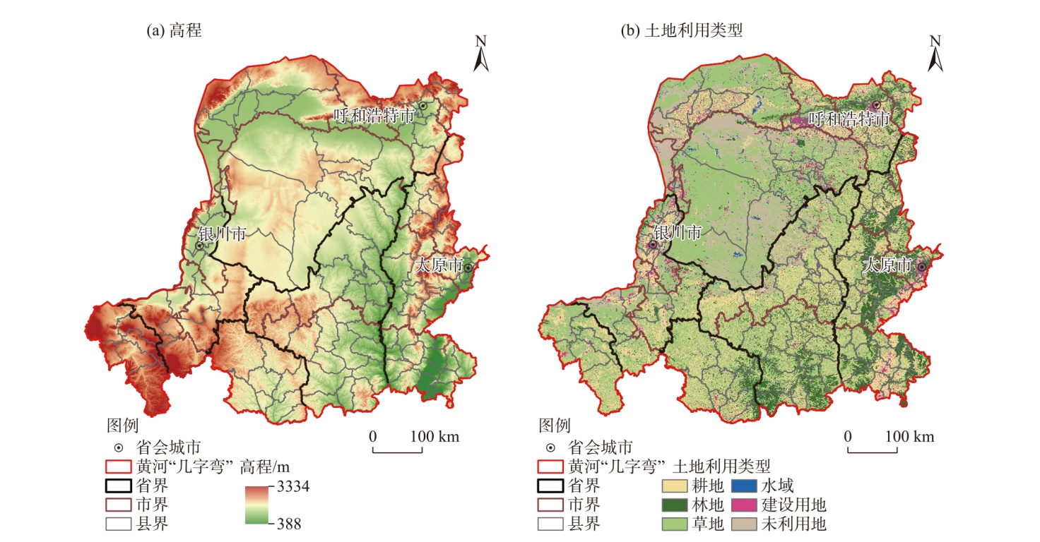
表1
数据来源及说明"
| 数据名称 | 分辨率 | 来源 |
|---|---|---|
| 降水量 | 1 km | 国家青藏高原数据中心( |
| 气温 | 1 km | 国家青藏高原数据中心( |
| 潜在蒸散发 | 1 km | 国家青藏高原数据中心( |
| 风速站点 | - | 美国国家海洋和大气管理局下设的国家环境信息中心( |
| 归一化植被指数 | 1 km | 美国国家航空航天局( |
| 土地利用类型 | 1 km | 中国科学院资源环境科学与数据中心( |
| 高程 | 90 m | 中国科学院资源环境科学与数据中心( |
| 土壤湿度 | 10 km | GLEAM4数据集[ |
| 实际蒸散发 | 4 km | TerraClimate数据集( |
| 人口密度 | 1 km | landscan( |
表2
影响因素及其含义"
| 数据类别 | 数据名称 | 简称 | 数据描述 |
|---|---|---|---|
| 自然环境 | 降水量/mm | PRE | 统计单元的年均降水量 |
| 气温/℃ | TEM | 统计单元的年均气温 | |
| 风速/m·s-1 | WIND | 统计单元10 m高度风速 | |
| 实际蒸散发/mm | AET | 统计单元实际蒸散发量 | |
| 潜在蒸散发/mm | PET | 统计单元潜在蒸散发量 | |
| 土壤湿度/% | SM | 统计单元土壤湿度 | |
| 归一化植被指数 | NDVI | 统计单元的归一化植被指数 | |
| 高程/m | DEM | 统计单元的高程值 | |
| 人类活动 | 人口密度/人·km-2 | POP | 统计单元的人口密度 |
| 新增耕地比例/% | GD | 统计单元2023年比2000年新增耕地面积占比 | |
| 新增城镇比例/% | CZ | 统计单元2023年比2000年新增建设用地占比 |
图2
土地退化中性(LDN)显性和隐性指标的状态"
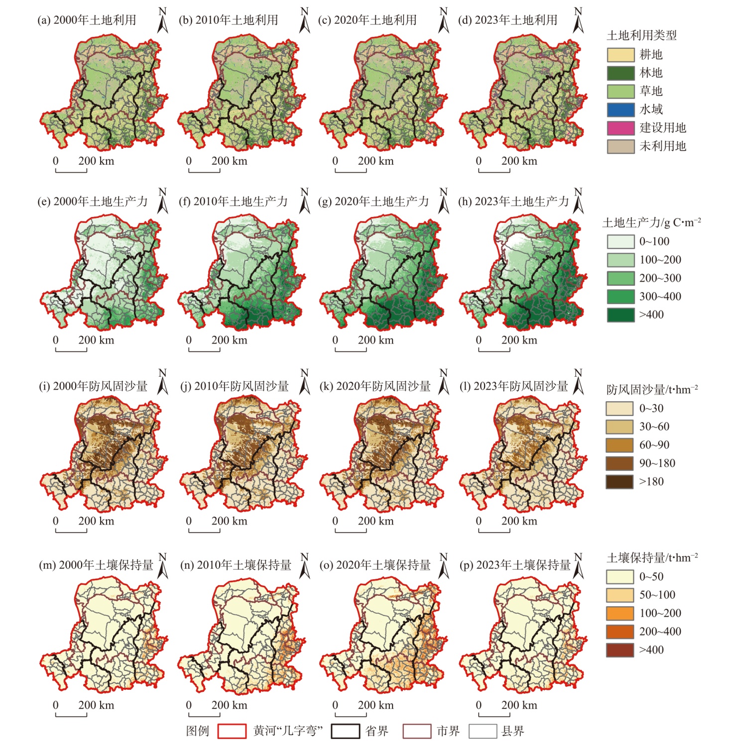

图3
LDN显性和隐性指标的变化趋势"
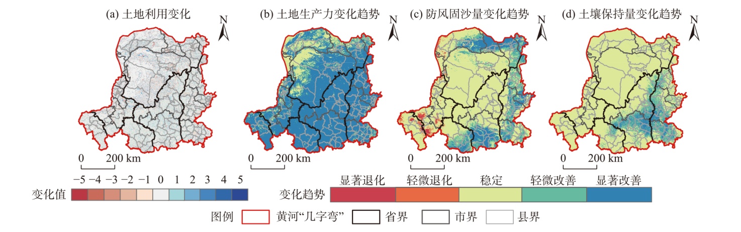

图4
LDN多尺度评估 注:LDN为土地退化中性。"
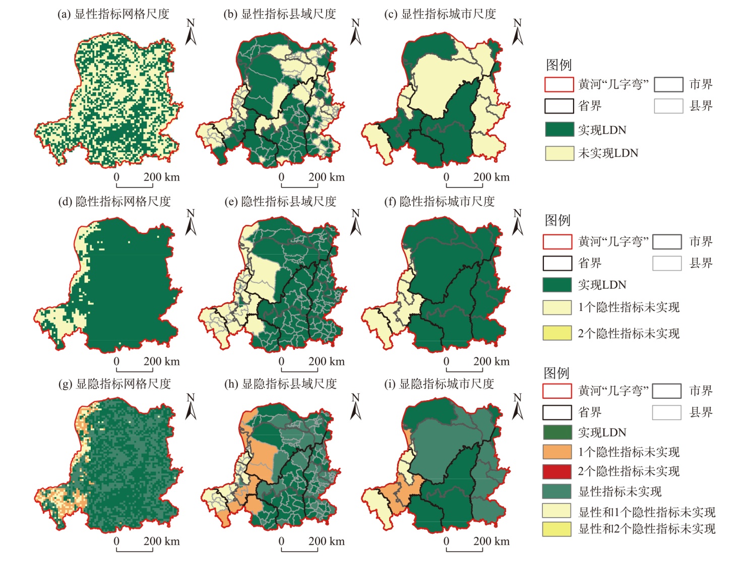
图5
影响因素对LDN空间格局的解释力 注:PRE为降水量;TEM为气温;PET为潜在蒸散发;AET为实际蒸散发;WIND为风速;POP为人口密度;GD为新增耕地比例;CZ为新增城镇比例;SM为土壤湿度;NDVI为归一化植被指数;DEM为高程。下同。"
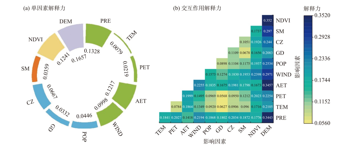
表3
OLS与GWR拟合参数比较"
| 模型诊断 信息 | 残差平方和 | 赤池信息准则 | R2 | 校正后R2 |
|---|---|---|---|---|
| OLS | 275.7117 | 607.0568 | 0.2378 | 0.2361 |
| GWR | 144.2750 | -1862.9000 | 0.6012 | 0.6004 |
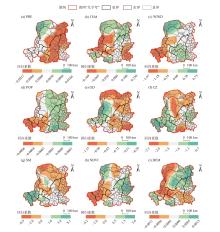
图6
LDN影响因素的回归系数分布"

| [1] | Cowie A L, Orr B J, Sanchez V M C, et al. Land in balance: The scientific conceptual framework for land degradation neutrality[J]. Environmental Science & Policy, 2018, 79: 25-35. |
| [2] |
As’ad N, Patrício L, Koskela-Huotari K, et al. Understanding service ecosystem dynamics: A typology[J]. Journal of Service Management, 2024, 35(6): 159-184.
doi: 10.1108/JOSM-07-2023-0322 |
| [3] | Fu B J, Liu Y X, Meadows M E. Ecological restoration for sustainable development in China[J]. National Science Review, 2023, 10(7): nwad033, doi: 10.1093/nsr/nwad033. |
| [4] | Meyfroidt P, De Bremond A, Ryan C M, et al. Ten facts about land systems for sustainability[J]. Proceedings of the National Academy of Sciences of the United States of America, 2022, 119(7): e2109217118, doi: 10.1073/pnas.2109217118. |
| [5] | 傅伯杰, 刘焱序, 赵文武. “一带一路”生态环境保护和可持续发展科技合作重点领域[J]. 中国科学院院刊, 2023, 38(9): 1273-1281. |
| [Fu Bojie, Liu Yanxu, Zhao Wenwu. Key areas for scientific and technological cooperation in ecological and environmental protection and sustainable development in the Belt and Road Initiative[J]. Bulletin of Chinese Academy of Sciences, 2023, 38(9): 1273-1281.] | |
| [6] | Yu H C, Yin D Y, Yang B, et al. Challenges for sustainable development goal of land degradation neutrality in drylands: Evidence from the northern slope of the Tianshan Mountains, China[J]. Science of the Total Environment, 2024, 932: 173094, doi: 10.1016/j.scitotenv.2024.173094. |
| [7] |
Wuepper D, Borrelli P, Panagos P, et al. A‘debt’ based approach to land degradation as an indicator of global change[J]. Global Change Biology, 2021, 27(21): 5407-5410.
doi: 10.1111/gcb.15830 pmid: 34480389 |
| [8] |
Ptichnikov A V, Martynyuk A A. Adaptation of international indicators of land degradation neutrality for the assessment of forest ecosystems in arid conditions in Russia[J]. Arid Ecosystems, 2020, 10(2): 127-134.
doi: 10.1134/S2079096120020109 |
| [9] | 王梦婧, 吕悦风, 吴次芳. 土地退化中性研究的国际进展及其中国路径[J]. 中国土地科学, 2020, 34(2): 64-74. |
| [Wang Mengjing, Lü Yuefeng, Wu Cifang. International research progress of land degradation neutrality and its implications in China[J]. China Land Science, 2020, 34(2): 64-74.] | |
| [10] | 郑欣雨, 吕楠, 张璐. 土地退化零增长评估——以蒙古高原为例[J]. 生态学报, 2023, 43(23): 9925-9937. |
| [Zheng Xinyu, Lü Nan, Zhang Lu. Taking land degradation neutrality from concept to practice: A case study of the Mongolian Plateau[J]. Acta Ecologica Sinica, 2023, 43(23): 9925-9937.] | |
| [11] | Yu H C, Yin D Y, Zhang J, et al. Multiscale analysis framework for assessing land degradation neutrality with ecosystem services: A case study of the Yellow River Basin[J]. Journal of Cleaner Production, 2023, 414: 137559, doi: 10.1016/j.jclepro.2023.137559. |
| [12] | Shi X P, An B S, Peng Y, et al. Exploration of the utilization of a new land degradation index in Lake Ebinur Basin in China[J]. Scientific Reports, 2024, 14(1): 17510, doi: 10.1038/s41598-024-68639-6. |
| [13] | Feng S Y, Zhao W W, Yan J M, et al. Land degradation neutrality assessment and factors influencing it in China’s arid and semiarid regions[J]. Science of the Total Environment, 2024, 925: 171735, doi: 10.1016/j.scitotenv.2024.171735. |
| [14] | 于昊辰, 卞正富, 陈浮. 矿山土地生态动态恢复机制: 基于LDN框架的分析[J]. 中国土地科学, 2020, 34(9): 86-95. |
| [Yu Haochen, Bian Zhengfu, Chen Fu. Dynamic mechanism of land ecological restoration in mining area: Based on land degradation neutrality (LDN) framework[J]. China Land Science, 2020, 34(9): 86-95.] | |
| [15] |
徐铭璟, 段宝玲, 冯强, 等. 生态系统服务及其权衡/协同关系多情景模拟——以黄河流域山西段为例[J]. 干旱区地理, 2025, 48(7): 1206-1219.
doi: 10.12118/j.issn.1000-6060.2024.471 |
|
[Xu Mingjing, Duan Baoling, Feng Qiang, et al. Multi-scenario simulation of ecosystem services and their trade-offs/synergistic relationships: A case study of Shanxi section in the Yellow River Basin[J]. Arid Land Geography, 2025, 48(7): 1206-1219.]
doi: 10.12118/j.issn.1000-6060.2024.471 |
|
| [16] | 李晓松, 卢琦, 贾晓霞. 地球大数据促进土地退化零增长目标实现: 实践与展望[J]. 中国科学院院刊, 2021, 36(8): 896-903. |
| [Li Xiaosong, Lu Qi, Jia Xiaoxia. Harnessing big earth data to facilitate land degradation neutrality goals: Practices and prospects[J]. Bulletin of Chinese Academy of Sciences 2021, 36(8): 896-903.] | |
| [17] | 史建阳, 刘旻霞, 李宇, 等. 黄河“几字弯”大气气溶胶光学厚度对植被总初级生产力的影响[J]. 中国环境科学, 2024, 44(6): 3314-3324. |
| [Shi Jianyang, Liu Minxia, Li Yu, et al. The impact of the depth of the Yellow River Ji shaped bay aerosol optical depth on the total primary productive forces of vegetation[J]. China Environmental Science, 2024, 44(6): 3314-3324.] | |
| [18] |
李森, 杨宗英, 赵鸿雁, 等. 1975—2020年黄河“几字弯”沙漠化时空变化[J]. 中国沙漠, 2024, 44(5): 13-22.
doi: 10.7522/j.issn.1000-694X.2024.00018 |
|
[Li Sen, Yang Zongying, Zhao Hongyan, et al. Spatio-temporal changes of aeolian desertification in the Jiziwan of the Yellow River from 1975 to 2020[J]. Journal of Desert Research, 2024, 44(5): 13-22.]
doi: 10.7522/j.issn.1000-694X.2024.00018 |
|
| [19] | Miralles D G, Bonte O, Koppa A, et al. GLEAM4: Global land evaporation and soil moisture dataset at 0.1° resolution from 1980 to near present[J]. Scientific Data, 2025, 12(1): 416, doi: 10.1038/s41597-025-04610-y. |
| [20] | Yin C C, Zhao W W, Pereira P. Ecosystem restoration along the “pattern-process-service-sustainability” path for achieving land degradation neutrality[J]. Landscape and Urban Planning, 2025, 253: 105227, doi: 10.1016/j.landurbplan.2024.105227. |
| [21] |
雷燕慧, 丁国栋, 李梓萌, 等. 京津风沙源治理工程区土地利用/覆盖变化及生态系统服务价值响应[J]. 中国沙漠, 2021, 41(6): 29-40.
doi: 10.7522/j.issn.1000-694X.2021.00085 |
|
[Lei Yanhui, Ding Guodong, Li Zimeng, et al. Land use/cover change and its ecosystem service value response in the Beijing-Tianjin sandstorm source control project area[J]. Journal of Desert Research, 2021, 41(6): 29-40.]
doi: 10.7522/j.issn.1000-694X.2021.00085 |
|
| [22] | 徐洁, 肖玉, 谢高地, 等. 防风固沙型重点生态功能区防风固沙服务的评估与受益区识别[J]. 生态学报, 2019, 39(16): 5857-5873. |
| [Xu Jie, Xiao Yu, Xie Gaodi, et al. Assessment of wind erosion prevention service and its beneficiary areas identification of national key ecological function zone of windbreak and sand fixation type in China[J]. Acta Ecologica Sinica, 2019, 39(16): 5857-5873.] | |
| [23] | Yin D Y, Li X S, Li G E, et al. Spatio-temporal evolution of land use transition and its eco-environmental effects: A case study of the Yellow River Basin, China[J]. Land, 2020, 9(12): 514, doi: 10.3390/land9120514. |
| [24] |
Potter C S, Randerson J T, Field C B, et al. Terrestrial ecosystem production: A process model based on global satellite and surface data[J]. Global Biogeochemical Cycles, 2010, 7(4): 811-841.
doi: 10.1029/93GB02725 |
| [25] | 黎猛, 李雅琪, 樊敏, 等. 基于“水-土-碳”动态耦合的甘孜州生态系统服务综合评估[J]. 环境科学, 2025, 46(5): 3070-3084. |
| [Li Meng, Li Yaqi, Fan Min, et al. Comprehensive evaluation of ecosystem services in Garzê Prefecture based on the dynamic coupling relationship of water-soil-carbon[J]. Environmental Science, 2025, 46(5): 3070-3084.] | |
| [26] |
邢丽珠, 张方敏, 邢开成, 等. 基于RWEQ模型的内蒙古巴彦淖尔市土壤风蚀变化特征及归因分析[J]. 中国沙漠, 2021, 41(5): 111-119.
doi: 10.7522/j.issn.1000-694X.2021.00055 |
|
[Xing Lizhu, Zhang Fangmin, Xing Kaicheng, et al. Change of soil wind erosion and attribution in Bayannur, Inner Mongolia based on the revised wind erosion equation[J]. Journal of Desert Research, 2021, 41(5): 111-119.]
doi: 10.7522/j.issn.1000-694X.2021.00055 |
|
| [27] | Teng Y M, Zhan J Y, Liu W, et al. Spatiotemporal dynamics and drivers of wind erosion on the Qinghai-Tibet Plateau, China[J]. Ecological Indicators, 2021, 123: 107340, doi: 10.1016/j.ecolind.2021.107340. |
| [28] | Chen Y P, Fu B J, Zhao Y, et al. Sustainable development in the Yellow River Basin: Issues and strategies[J]. Journal of Cleaner Production, 2020, 263: 121223, doi: 10.1016/j.jclepro.2020.121223. |
| [29] |
Yu H C, Yin D Y, Gong P, et al. Integrated protection and restoration for full-array ecosystems in dryland: A perspective of land degradation neutrality[J]. Journal of Natural Resources, 2024, 39(9): 2066-2086.
doi: 10.31497/zrzyxb.20240904 |
| [30] |
Ronald E J, Sangermano F, Ghimire B, et al. Seasonal trend analysis of image time series[J]. International Journal of Remote Sensing, 2009, 30(10): 2721-2726.
doi: 10.1080/01431160902755338 |
| [31] | Chen J L, Shao Z F, Huang X, et al. Assessing the impact of drought-land cover change on global vegetation greenness and productivity[J]. Science of the Total Environment, 2022, 852: 158499, doi: 10.1016/j.scitotenv.2022.158499. |
| [32] | Jiang L L, Bao A M, Jiapaer G, et al. Monitoring land degradation and assessing its drivers to support sustainable development goal 15.3 in Central Asia[J]. Science of the Total Environment, 2022, 807: 150868, doi: 10.1016/j.scitotenv.2021.150868. |
| [33] | Dang H, Lü Y H, Wang X F, et al. Land degradation neutrality in mountainous region: Dynamics, driving factors, and management implications[J]. Applied Geography, 2025, 181: 103691, doi: 10.1016/j.apgeog.2025.103691. |
| [34] | Shao W Y, Zhang Z P, Guan Q Y, et al. Comprehensive assessment of land degradation in the arid and semiarid area based on the optimal land degradation index model[J]. Catena, 2024, 234: 107563, doi: 10.1016/j.catena.2023.107563. |
| [35] |
邢梦祥, 郑江华, 李刚勇, 等. 2001—2020年塔城地区草地健康时空变化特征及其驱动力分析[J]. 干旱区地理, 2025, 48(4): 673-688.
doi: 10.12118/j.issn.1000-6060.2024.392 |
|
[Xing Mengxiang, Zheng Jianghua, Li Gangyong, et al. Spatiotemporal dynamics and driving forces of grassland health in Tacheng Prefecture from 2001 to 2020[J]. Arid Land Geography, 2025, 48(4): 673-688.]
doi: 10.12118/j.issn.1000-6060.2024.392 |
|
| [36] |
管卫华, 吴小妮, 李焕兰, 等. 改革开放以来中国区域城镇化格局及演化机制[J]. 地理科学, 2025, 45(2): 265-277.
doi: 10.13249/j.cnki.sgs.20230576 |
| [Guan Weihua, Wu Xiaoni, Li Huanlan, et al. Evolution and mechanism of China’s regional urbanization pattern[J]. Geographical Science, 2025, 45(2): 265-277.] | |
| [37] | Powers S L, Matthews S A, Mowen A J. Does the relationship between racial, ethnic, and income diversity and social capital vary across the United States? A county-level analysis using geographically weighted regression[J]. Applied Geography, 2021, 130: 102446, doi: 10.1016/j.apgeog.2021.102446. |
| [38] |
Grossiord C, Buckley T N, Cernusak L A, et al. Plant responses to rising vapor pressure deficit[J]. New Phytologist, 2020, 226(6): 1550-1566.
doi: 10.1111/nph.16485 pmid: 32064613 |
| [39] | Qu Y B, Zhan L Y, Wei C C, et al. Interactive transition of cultivated land and construction land during china’s urbanization: A coordinated analytical framework of explicit and implicit forms[J]. Land Use Policy, 2024, 138: 107049, doi: 10.1016/j.landusepol.2024.107049. |
| [40] |
薄立明, 尹力, 魏伟, 等. 2000—2020年河西走廊国土空间格局演变特征及驱动力分析[J]. 干旱区地理, 2024, 47(5): 885-897.
doi: 10.12118/j.issn.1000-6060.2023.479 |
|
[Bo Liming, Yin Li, Wei Wei, et al. Evolution characteristics and its driving mechanism of territorial spatial pattern in the Hexi Corridor from 2000 to 2020[J]. Arid Land Geography, 2024, 47(5): 885-897.]
doi: 10.12118/j.issn.1000-6060.2023.479 |
|
| [41] |
Barbier E B, Hochard J P. Land degradation and poverty[J]. Nature Sustainability, 2018, 1(11): 623-631.
doi: 10.1038/s41893-018-0155-4 |
| [42] | Feng S Y, Liu X, Zhao W W, et al. Key areas of ecological restoration in Inner Mongolia based on ecosystem vulnerability and ecosystem service[J]. Remote Sensing, 2022, 14(12): 2729, doi: 10.3390/rs14122729. |
| [43] |
Górriz-Mifsud E, Varela E, Piqué M, et al. Demand and supply of ecosystem services in a Mediterranean forest: Computing payment boundaries[J]. Ecosystem Services, 2016, 17: 53-63.
doi: 10.1016/j.ecoser.2015.11.006 |
| [1] | 陈文宣, 陈钰, 王生隆. 黄河流域农业碳排放时空演化特征及其影响因素分析[J]. 干旱区地理, 2026, 49(4): 713-726. |
| [2] | 周灵敏, 伊木然·库鲁万, 玉素甫江·如素力, 吴海智, 娜扎开提·尼加提. 中国西北干旱区大型湖泊湖冰物候时空差异及影响因素[J]. 干旱区地理, 2026, 49(3): 484-495. |
| [3] | 屠正伟, 张沛, 张中华. 银川都市圈乡村“三生空间”冲突格局演变特征及影响因素[J]. 干旱区地理, 2026, 49(3): 594-606. |
| [4] | 张嘉伟, 裴婷婷, 陈英, 谢保鹏. 大食物观下甘肃省粮食和重要农产品供给安全评价及影响因素[J]. 干旱区地理, 2026, 49(3): 619-630. |
| [5] | 魏丽蓉, 程占红, 石烨, 张玉尧, 王紫彦, 牛莉芹. 黄河流域旅游生态安全的演化特征和影响因素分析——基于社会网络分析视角[J]. 干旱区地理, 2026, 49(2): 245-254. |
| [6] | 曾勇, 毕钰, 张洪彬, 施枫芝, 王鹏. 塔里木河流域生态系统服务价值与土地利用的动态变化[J]. 干旱区地理, 2026, 49(2): 265-274. |
| [7] | 刘昊, 李福莲, 汪圣. 中国居家社区养老与机构养老耦合协调格局及影响因素研究[J]. 干旱区地理, 2026, 49(2): 381-392. |
| [8] | 杨迪, 邹进, 马晓飞, 张珣, 周锐, 刘艳春, 石金莲. 体育旅游资源空间分布特征及可持续发展研究——以新疆为例[J]. 干旱区地理, 2026, 49(1): 140-150. |
| [9] | 戢晓峰, 李子歆, 曹瑞, 李武, 陈方. 地级市尺度下中国物流企业空间格局演化特征及影响因素[J]. 干旱区地理, 2026, 49(1): 176-185. |
| [10] | 王雅俊, 王一峰. 宁夏易地扶贫搬迁安置区融入新型城镇化效果评价及影响因素[J]. 干旱区地理, 2026, 49(1): 186-197. |
| [11] | 李佳琳, 李新虎, 王弘超, 崔萌萌, 郭语博, 靳浩东, 任萧萧. 不同影响因素下盐结皮蒸发阻力定量模拟研究[J]. 干旱区地理, 2026, 49(1): 80-93. |
| [12] | 黄静, 李婷, 李朋飞, Altansukh OCHIR, 杨梅焕, 王涛, 李莎. 2000—2020年蒙古国植被净初级生产力时空演变特征及其影响因素[J]. 干旱区地理, 2025, 48(9): 1541-1554. |
| [13] | 张可心, 赵玉娟, 李美瑜. 1978—2023年陇东冰雹气候特征及其影响因素分析[J]. 干旱区地理, 2025, 48(8): 1374-1384. |
| [14] | 王嘉伟, 董国涛, 蒋晓辉, 聂桐, 李跃红. 生态输水背景下黑河流域生态系统服务的时空演变特征及驱动力研究[J]. 干旱区地理, 2025, 48(8): 1406-1420. |
| [15] | 程鹏, 彭海洋, 侯丁榕, 孙明东, 宋晓伟. 黄河流域农业灰水足迹强度空间格局及演进趋势[J]. 干旱区地理, 2025, 48(7): 1185-1197. |
|
||