干旱区地理 ›› 2026, Vol. 49 ›› Issue (4): 841-855.doi: 10.12118/j.issn.1000-6060.2025.580 cstr: 32274.14.ALG2025580
曹浩然1,2( ), 孟梅1(), 刘红光2
收稿日期:2025-09-25
修回日期:2025-12-26
出版日期:2026-04-25
发布日期:2026-04-28
通讯作者:
孟梅(1973-),女,博士,教授,主要从事农业经济、耕地保护等方面的研究. E-mail: mengmeihh@163.com作者简介:曹浩然(2000-),女,博士研究生,主要从事干旱区耕地保护等方面的研究. E-mail: caohaoran@stu.njau.edu.cn
基金资助:
CAO Haoran1,2(), MENG Mei1(), LIU Hongguang2
Received:2025-09-25
Revised:2025-12-26
Published:2026-04-25
Online:2026-04-28
摘要:
为探究甘肃省2000—2024年土地生态脆弱性的时空演变规律及未来变化趋势,构建基于“敏感性-恢复力-压力度”(SRP)模型的评价体系,采用熵权法、地理探测器与CA-Markov模型,对2000—2024年的生态脆弱性进行定量分析与2030、2035年模拟预测。结果表明:(1) 2000—2024年甘肃省土地生态脆弱性显著下降,生态系统稳定性增强,脆弱等级由“高脆弱主导”转为“轻-中度主导”。(2) 空间格局呈“西北高、东南低”梯度特征,高值区收缩、低值区扩展。(3) 年蒸散发量、归一化植被指数与日照时数为主导因子且交互作用最强,反映气候与植被共同调控土地生态系统脆弱性。(4) 模拟预测至2035年,微度与轻度脆弱区占比达65.5%,极度脆弱区基本消失,生态格局持续优化。研究表明甘肃省土地生态系统整体呈“持续恢复-稳步优化”的演变趋势,生态修复政策与气候适应性治理共同促进区域生态安全格局稳步重塑,为西北地区生态安全格局优化与适应性治理策略制定提供了定量化科学依据。
曹浩然, 孟梅, 刘红光. 2000—2024年甘肃省土地生态脆弱性时空变化特征及模拟预测研究[J]. 干旱区地理, 2026, 49(4): 841-855.
CAO Haoran, MENG Mei, LIU Hongguang. Spatiotemporal variation characteristics and simulation prediction of land ecological vulnerability in Gansu Province from 2000 to 2024[J]. Arid Land Geography, 2026, 49(4): 841-855.
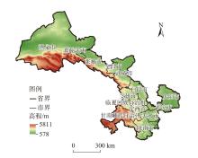
图1
研究区示意图 注:基于自然资源部标准地图服务网站审图号为GS(2024)0650号的标准地图制作,底图边界无修改。下同。"
表1
数据来源"
| 数据名称 | 年份 | 数据来源及分辨率 |
|---|---|---|
| DEM数据 | 2024 | 地理空间数据云( |
| 气象数据 | 2000、2005、2010、2015、2020、2024 | 国家地球系统科学数据中心( |
| 土壤数据 | 2023 | HWSD2.0( |
| 遥感数据 | 2000、2005、2010、2015、2020、2024 | 美国地质调查局(USGS)官方数据平台( |
| MODIS数据 | 2000、2005、2010、2015、2020、2024 | 美国国家航空航天局(NASA)地球数据检索系统( |
| 地理信息数据 | 2024 | 资源环境科学与数据平台( |
| 社会经济数据 | 2000、2005、2010、2015、2020、2024 | 《甘肃统计年鉴(2001—2025)》《甘肃省农经统计报表(2000—2024)》 |
表2
土地生态脆弱性评价指标体系"
| 目标层 | 准则层 | 次准则层 | 影响因子层 | 属性 |
|---|---|---|---|---|
| 土地生态脆弱性评价 | 敏感度 | 地形因子(静态) | 高程 | 正向 |
| 坡度 | 定性 | |||
| 地形起伏度 | 定性 | |||
| 地表粗糙度 | 正向 | |||
| 气象因子(动态) | 年均气温 | 负向 | ||
| 干旱指数 | 正向 | |||
| 环境因子(动态) | 水土流失 | 正向 | ||
| 水源涵养能力 | 负向 | |||
| 土壤因子(动态) | 土壤沙化度 | 定性 | ||
| 土壤盐渍化 | 定性 | |||
| 土壤碳储量 | 负向 | |||
| 土壤水分 | 负向 | |||
| 恢复力 | 植被因子(动态) | NDVI | 负向 | |
| NPP | 负向 | |||
| 多样性因子(动态) | 生物丰度 | 负向 | ||
| 水文因子(动态) | 河流缓冲区 | 正向 | ||
| 压力 | 社会因子(动态) | 人口密度 | 正向 | |
| 人均GDP | 正向 |
表3
指标量化标准"
| 指标层 | 指标量化标准 | ||||
|---|---|---|---|---|---|
| 0.00 | 0.25 | 0.50 | 0.75 | 1.00 | |
| 坡向/(°) | 157.5~202.5 | 112.5~157.5,202.5~247.5 | 67.5~112.5,247.5~292.5 | 22.5~67.5,292.5~337.5 | 0.0~22.5,337.5~360.0 |
| 坡度/(°) | 0~5 | 5~10 | 10~15 | 15~25 | >25 |
| 土壤沙化度/g·kg-1 | 25 | 25~40 | 40~55 | 55~70 | >70 |
| 土壤盐渍化/g·kg-1 | 1 | - | 3 | - | 6 |
图2
甘肃省土地生态脆弱性评价指标权重气泡图 注:NDVI为归一化植被指数;NPP为净初级生产力。"
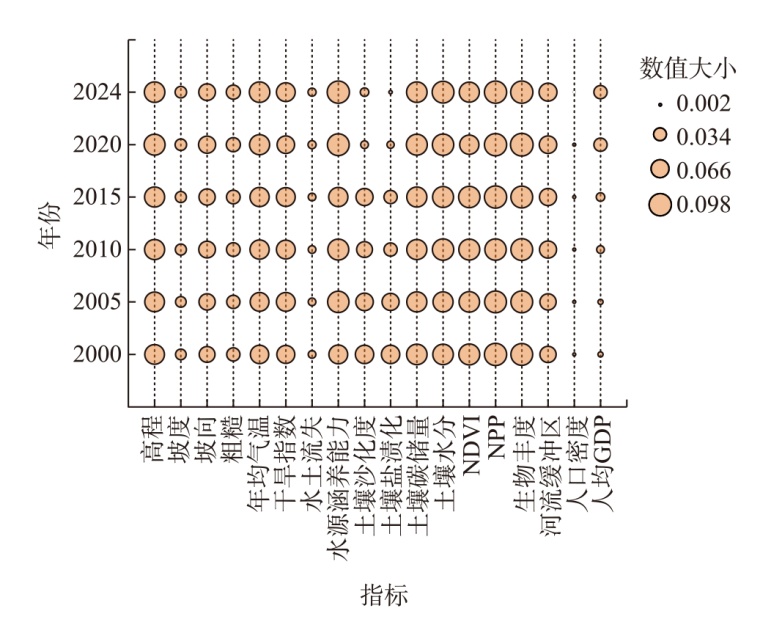
表4
甘肃省土地生态脆弱性分级标准"
| 脆弱类型 | 脆弱等级 | 分级范围 | 生态效果 |
|---|---|---|---|
| 微度脆弱 | Ⅰ | <0.40 | 土地生态系统结构完整,生态服务功能价值显著,稳定性良好,抗扰动能力与恢复潜力强,生态环境风险水平低 |
| 轻度脆弱 | Ⅱ | 0.40~0.50 | 土地生态系统结构相对完整,生态服务功能价值可观,稳定性较好,具备一定抗扰动能力与较强恢复潜力,存在潜在生态风险 |
| 中度脆弱 | Ⅲ | 0.50~0.58 | 土地生态系统处于临界状态,结构完整性受挑战,生态服务功能有限;稳定性差,扰动缓冲能力接近阈值,敏感性显著;自然恢复缓慢低效,已显现生态退化迹象 |
| 重度脆弱 | Ⅳ | 0.58~0.65 | 土地生态系统结构缺陷明显,生态服务功能显著退化;稳定性严重不足,对外界压力高度敏感;自我调节与恢复机制受损,多重生态风险显现,系统整体失衡 |
| 极度脆弱 | Ⅴ | >0.65 | 土地生态系统结构高度脆弱,生态服务功能严重退化;处于高度不稳定状态,对高强度外界压力极端敏感;自然恢复能力基本丧失,区域生态异常广泛存在,系统濒临崩溃 |
表5
影响因素及数据来源"
| 类别 | 影响因子 | 数据来源 |
|---|---|---|
| 社会经济因子 | 人为影响综合指数(X1) | 中国科学院资源环境科学数据中心 |
| 耕地面积比重(X2) | 《甘肃省统计年鉴》 | |
| 人口增长率(X3) | 《甘肃省统计年鉴》 | |
| 城市化率(X4) | 《甘肃省统计年鉴》 | |
| 自然因素 | NDVI(X5) | 中国科学院资源环境科学数据中心 |
| 地形起伏度(X6) | 地理空间数据云DEM数据 | |
| 平均日照时数(X7) | 国家地球系统科学数据中心 | |
| 年蒸散发量(X8) | 国家地球系统科学数据中心 | |
| 土壤类型(X9) | 国家青藏高原科学数据中心,并结合FAO1990的土壤分类 | |
| 景观因素 | 生态用地比例(X10) | 中国科学院资源环境科学数据中心;第三次全国国土调查成果分析报告 |
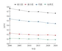
图3
2000—2024年甘肃省土地生态脆弱性指数 注:LEVI为土地生态脆弱性指数。下同。"
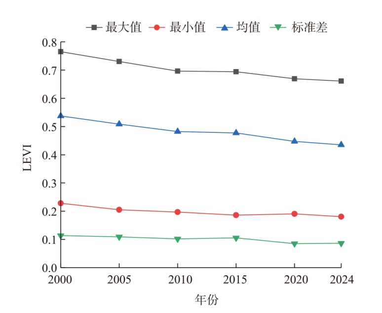
表6
2000—2024年甘肃省土地生态脆弱性面积及比例"
| 脆弱类型 | 2000年 | 2005年 | 2010年 | 2015年 | 2020年 | 2024年 | |||||||||||
|---|---|---|---|---|---|---|---|---|---|---|---|---|---|---|---|---|---|
| 面积/km2 | 占比/% | 面积/km2 | 占比/% | 面积/km2 | 占比/% | 面积/km2 | 占比/% | 面积/km2 | 占比/% | 面积/km2 | 占比/% | ||||||
| 微度脆弱 | 70441.67 | 16.54 | 92745.38 | 21.78 | 112913.85 | 26.52 | 119256.13 | 28.01 | 139340.04 | 32.72 | 155618.58 | 36.55 | |||||
| 轻度脆弱 | 67143.68 | 15.77 | 70357.10 | 16.52 | 73845.36 | 17.34 | 69976.57 | 16.43 | 104520.89 | 24.55 | 110207.80 | 25.88 | |||||
| 中度脆弱 | 62915.49 | 14.78 | 69257.77 | 16.27 | 95366.85 | 22.40 | 99933.30 | 23.47 | 137437.36 | 32.28 | 132046.41 | 31.01 | |||||
| 重度脆弱 | 148663.20 | 34.91 | 168641.41 | 39.61 | 138557.83 | 32.54 | 132109.84 | 31.03 | 44396.01 | 10.43 | 27863.78 | 6.54 | |||||
| 极度脆弱 | 76635.97 | 18.00 | 24798.34 | 5.82 | 5116.11 | 1.20 | 4524.16 | 1.06 | 105.70 | 0.02 | 63.42 | 0.01 | |||||
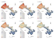
图4
2000—2024年甘肃省土地生态脆弱性空间分布"
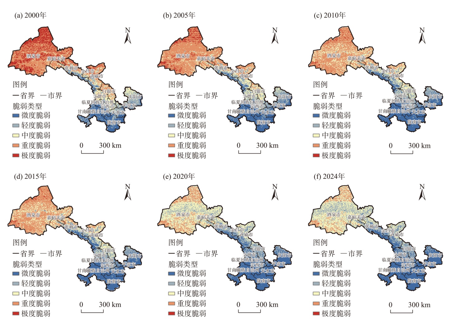
图5
2000—2024年甘肃省LEVI莫兰散点图"
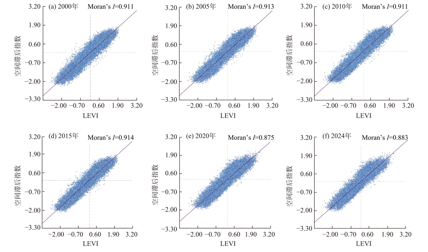
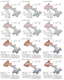
图6
2000—2024年甘肃省土地生态脆弱性LISA聚类与冷热点分析"

表7
2000—2024年甘肃省土地生态脆弱性影响因子探测结果"
| 影响因子 | 解释力(q值) | |||||
|---|---|---|---|---|---|---|
| 2000年 | 2005年 | 2010年 | 2015年 | 2020年 | 2024年 | |
| X1 | 0.378 | 0.277 | 0.274 | 0.278 | 0.295 | 0.310 |
| X2 | 0.082 | 0.080 | 0.101 | 0.156 | 0.125 | 0.130 |
| X3 | 0.122 | 0.163 | 0.183 | 0.218 | 0.215 | 0.210 |
| X4 | 0.030 | 0.129 | 0.160 | 0.123 | 0.024 | 0.035 |
| X5 | 0.417 | 0.514 | 0.589 | 0.557 | 0.586 | 0.600 |
| X6 | 0.007 | 0.029 | 0.124 | 0.022 | 0.027 | 0.030 |
| X7 | 0.589 | 0.517 | 0.456 | 0.467 | 0.555 | 0.560 |
| X8 | 0.453 | 0.594 | 0.451 | 0.418 | 0.650 | 0.670 |
| X9 | 0.031 | 0.023 | 0.026 | 0.117 | 0.013 | 0.020 |
| X10 | 0.224 | 0.255 | 0.276 | 0.240 | 0.219 | 0.225 |
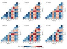
图7
2000—2024年甘肃省土地生态脆弱性影响因子交互探测结果 注:X1为人为影响综合指数;X2为耕地面积比重;X3为人口增长率;X4为城市化率;X5为NDVI;X6为地形起伏度;X7为平均日照时数;X8为年蒸散发量;X9为土壤类型;X10为生态用地比例。"
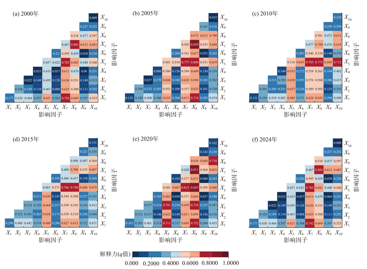
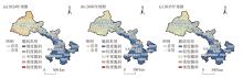
图8
2024—2035年甘肃省土地生态脆弱性模拟预测结果"

表8
2024—2035年甘肃省土地生态脆弱性预测变化"
| 脆弱类型 | 2024年 | 2030年 | 2035年 | |||||
|---|---|---|---|---|---|---|---|---|
| 面积/km2 | 占比/% | 面积/km2 | 占比/% | 面积/km2 | 占比/% | |||
| 微度脆弱 | 159360.53 | 37.43 | 164962.88 | 38.74 | 163144.76 | 38.31 | ||
| 轻度脆弱 | 108854.78 | 25.56 | 117564.86 | 27.61 | 115831.30 | 27.20 | ||
| 中度脆弱 | 63824.55 | 14.99 | 123484.33 | 29.00 | 125936.68 | 29.58 | ||
| 重度脆弱 | 93591.01 | 21.98 | 19766.79 | 4.64 | 20866.12 | 4.90 | ||
| 极度脆弱 | 169.13 | 0.04 | 21.14 | 0.01 | 21.14 | 0.01 | ||
| [1] | 邸乘光. 论习近平新时代中国特色社会主义思想[J]. 新疆师范大学学报(哲学社会科学版), 2018, 39(2): 7-21. |
| [Di Chengguang. On Xi Jinping thought on socialism with Chinese characteristics for a new era[J]. Journal of Xinjiang Normal University (Philosophy and Social Sciences), 2018, 39(2): 7-21.] | |
| [2] | 高世楫, 王海芹, 李维明. 改革开放40年生态文明体制改革历程与取向观察[J]. 改革, 2018(8): 49-63. |
| [Gao Shiji, Wang Haiqin, Li Weiming. Course and orientation of ecological civilization system reform over 40 years of reform and opening-up[J]. Reform, 2018(8): 49-63.] | |
| [3] | 刘愿理, 廖和平, 李靖, 等. 生态脆弱区土地利用多功能空间格局特征及影响因素分析[J]. 中国土地科学, 2020, 34(2): 75-83. |
| [Liu Yuanli, Liao Heping, Li Jing, et al. Analysis of characteristics and influencing factors of multi-functional spatial pattern of land use in ecological frangible regions[J]. China Land Science, 2020, 34(2): 75-83.] | |
| [4] | 赵哲远, 吴次芳, 顾海杰, 等. 关于土地生态管理的探讨[J]. 浙江国土资源, 2003(6): 31-34. |
| [Zhao Zheyuan, Wu Cifang, Gu Haijie, et al. Discussion on land ecological management[J]. Zhejiang Land & Resources, 2003(6): 31-34.] | |
| [5] |
Metzger M J, Rounsevell M D A, Acosta-Michlik L, et al. The vulnerability of ecosystem services to land use change[J]. Agriculture, Ecosystems & Environment, 2006, 114(1): 69-85.
doi: 10.1016/j.agee.2005.11.025 |
| [6] |
Butterbach-Bahl K, Kögel-Knabner I, Han X G. Steppe ecosystems and climate and land-use changes: Vulnerability, feedbacks and possibilities for adaptation[J]. Plant and Soil, 2011, 340: 1-6.
doi: 10.1007/s11104-010-0651-4 |
| [7] |
Finkl C W, Charlier R H, Krupa S L. Vulnerability of coastal environments to land use and abuse: The example of southeast Florida[J]. International Journal of Environmental Studies, 2005, 62(5): 535-554.
doi: 10.1080/00207230500196278 |
| [8] |
Birkmann J. Risk and vulnerability indicators at different scales: Applicability, usefulness and policy implications[J]. Environmental Hazards, 2007, 7(1): 20-31.
doi: 10.1016/j.envhaz.2007.04.002 |
| [9] | Hou K, Tao W D, He D, et al. A new perspective on ecological vulnerability and its transformation mechanisms[J]. Ecosystem Health and Sustainability, 2022, 8(1): 2115403, doi: 10.1080/20964129.2022.2115403. |
| [10] | 安芬, 李旭东, 程东亚. 贵州省乌江流域生态脆弱性评价及其空间变化特征[J]. 水土保持通报, 2019, 39(4): 261-269. |
| [An Fen, Li Xudong, Cheng Dongya. Ecological vulnerability assessment and spatial variation characteristics of Wujiang River Basin in Guizhou Province[J]. Bulletin of Soil and Water Conservation, 2019, 39(4): 261-269.] | |
| [11] | 韦晶, 郭亚敏, 孙林, 等. 三江源地区生态环境脆弱性评价[J]. 生态学杂志, 2015, 34(7): 1968-1975. |
| [Wei Jing, Guo Yamin, Sun Lin, et al. Evaluation of ecological environment vulnerability for Sanjiangyuan area[J]. Chinese Journal of Ecology, 2015, 34(7): 1968-1975.] | |
| [12] | 马骏, 李昌晓, 魏虹, 等. 三峡库区生态脆弱性评价[J]. 生态学报, 2015, 35(21): 7117-7129. |
| [Ma Jun, Li Changxiao, Wei Hong, et al. Dynamic evaluation of ecological vulnerability in the Three Gorges Reservoir Region in Chongqing Municipality, China[J]. Acta Ecologica Sinica, 2015, 35(21): 7117-7129.] | |
| [13] | 陈枫, 李泽红, 董锁成, 等. 基于VSD模型的黄土高原丘陵沟壑区县域生态脆弱性评价——以甘肃省临洮县为例[J]. 干旱区资源与环境, 2018, 32(11): 74-80. |
| [Chen Feng, Li Zehong, Dong Suocheng, et al. Evaluation of ecological vulnerability in gully-hilly region of Loess Plateau based on VSD model: A case of Lintao County[J]. Journal of Arid Land Resources and Environment, 2018, 32(11): 74-80.] | |
| [14] | 郭荣中, 申海建, 杨敏华. 基于改进PSR模型的长株潭地区土地生态系统健康评价研究[J]. 环境监测管理与技术, 2021, 33(3): 29-34. |
| [Guo Rongzhong, Shen Haijian, Yang Minhua. Studies on land ecosystem health evaluation in Chang-Zhu-Tan Region based on the improved PSR model[J]. The Administration and Technique of Environmental Monitoring, 2021, 33(3): 29-34.] | |
| [15] |
王同达, 曹锦雪, 赵永华, 等. 基于PSR模型的陕西省土地生态系统健康评价[J]. 应用生态学报, 2021, 32(5): 1563-1572.
doi: 10.13287/j.1001-9332.202105.013 |
|
[Wang Tongda, Cao Jinxue, Zhao Yonghua, et al. Evaluation of land ecosystem health in Shaanxi Province, northwest China based on PSR model[J]. Chinese Journal of Applied Ecology, 2021, 32(5): 1563-1572.]
doi: 10.13287/j.1001-9332.202105.013 |
|
| [16] |
江文甲, 林满红, 翁佩莹, 等. 福建安溪县乡镇土地生态系统服务价值的演变机制[J]. 应用生态学报, 2021, 32(12): 4457-4566.
doi: 10.13287/j.1001-9332.202110.011 |
|
[Jiang Wenjia, Lin Manhong, Weng Peiying, et al. Evolution mechanism of ecosystem service value at the township-scale in Anxi County of Fujian Province, China[J]. Chinese Journal of Applied Ecology, 2021, 32(12): 4457-4566.]
doi: 10.13287/j.1001-9332.202110.011 |
|
| [17] | 高洁芝, 郑华伟, 刘友兆. 基于DPSIR模型的土地生态系统健康诊断[J]. 江苏农业科学, 2021, 49(11): 178-185. |
| [Gao Jiezhi, Zheng Huawei, Liu Youzhao. Health diagnosis of land ecosystem based on DPSIR model[J]. Jiangsu Agricultural Sciences, 2021, 49(11): 178-185.] | |
| [18] | 王振鹏, 蒲泓君. 基于生态系统服务价值的土地生态敏感性研究[J]. 农业与技术, 2021, 41(13): 119-122. |
| [Wang Zhenpeng, Pu Hongjun. Study on land ecological sensitivity based on ecosystem service value[J]. Agriculture and Technology, 2021, 41(13): 119-122.] | |
| [19] | Kamran M, Yamamoto K. Evolution and use of remote sensing in ecological vulnerability assessment: A review[J]. Ecological Indicators, 2023, 147: 110024, doi: 10.1016/j.ecolind.2023.110024. |
| [20] | Lan G X, Jiang X L, Xu D H, et al. Ecological vulnerability assessment based on remote sensing ecological index (RSEI): A case of Zhongxian County, Chongqing[J]. Frontiers in Environmental Science, 2023, 11: 1074376, doi: 10.1016/j.ecolind.2023.110099. |
| [21] |
Guo B, Xu M, Zhang R, et al. A new monitoring index for ecological vulnerability and its application in the Yellow River Basin, China from 2000 to 2022[J]. Journal of Arid Land, 2024, 16(9): 1163-1182.
doi: 10.1007/s40333-024-0106-z |
| [22] | Xu M, Cao C X, Zhong S B, et al. Ecological vulnerability assessment and spatial-temporal variations analysis in typical ecologically vulnerable areas of China[J]. Frontiers in Ecology and Evolution, 2024, 12: 1406444, doi: 10.3389/fevo.2024.1406444. |
| [23] | 张帅, 董会忠, 曾文霞. 土地生态系统脆弱性时空演化特征及影响因素——以黄河三角洲高效生态经济区为例[J]. 中国环境科学, 2019, 39(4): 1696-1704. |
| [Zhang Shuai, Dong Huizhong, Zeng Wenxia. The time-space evolution characteristics of the vulnerability of land ecosystems and influencing factors: A case study of the Yellow River delta efficiency eco-economic zone[J]. China Environmental Science, 2019, 39(4): 1696-1704.] | |
| [24] | 乌宁巴特, 刘新平, 马相平. 叶尔羌河流域土地生态脆弱性差异评价[J]. 干旱区地理, 2020, 43(3): 849-858. |
| [Wu Ningbart, Liu Xinping, Ma Xiangping. Evaluation on the difference of land ecological vulnerability in the Yarkant River Basin[J]. Arid Land Geography, 2020, 43(3): 849-858.] | |
| [25] | 张行, 陈海, 史琴琴, 等. 陕西省景观生态脆弱性时空演变及其影响因素[J]. 干旱区研究, 2020, 37(2): 496-505. |
| [Zhang Hang, Chen Hai, Shi Qinqin, et al. Spatiotemporal evolution and driving factors of landscape ecological vulnerability in Shaanxi Province[J]. Arid Zone Research, 2020, 37(2): 496-505.] | |
| [26] | 魏明欢, 胡波洋, 张贵军, 等. 山区县土地生态脆弱性动态变化分析——以青龙满族自治县为例[J]. 水土保持研究, 2018, 25(2): 322-327. |
| [Wei Minghuan, Hu Boyang, Zhang Guijun, et al. Analysis on dynamic change of land ecological vulnerability in mountainous county: Taking Qinglong Manchu Autonomous County as an example[J]. Research of Soil and Water Conservation, 2018, 25(2): 322-327.] | |
| [27] | 高文明, 宋芊, 张皓翔, 等. 三江源区生态脆弱性时空演变及驱动因素分析[J]. 环境工程学报, 2024, 33(10): 1648-1660. |
| [Gao Wenming, Song Qian, Zhang Haoxiang, et al. Analysis of spatial and temporal changes and driving factors of ecological vulnerability in Sanjiangyuan Region[J]. Chinese Journal of Environmental Engineering, 2024, 33(10): 1648-1660.] | |
| [28] |
Feng Y, He D M. Transboundary water vulnerability and its drivers in China[J]. Journal of Geographical Sciences, 2009, 19: 189-199.
doi: 10.1007/s11442-009-0189-7 |
| [29] | 厉彦玲. 基于灰色聚类分析方法的生态环境质量综合评价模型[J]. 测绘科学, 2007, 32(5): 77-79, 203. |
| [Li Yanling. Ecological environment quality comprehensive evaluation model based on grey clustering[J]. Science of Surveying and Mapping, 2007, 32(5): 77-79, 203.] | |
| [30] | 邱彭华, 徐颂军, 谢跟踪, 等. 基于景观格局和生态敏感性的海南西部地区生态脆弱性分析[J]. 生态学报, 2007, 27(4): 1257-1264. |
|
[Qiu Penghua, Xu Songjun, Xie Gengzong, et al. Analysis on the ecological vulnerability of the western Hainan Island based on its landscape pattern and ecosystem sensitivity[J]. Acta Ecologica Sinica, 2007, 27(4): 1257-1264.]
doi: 10.1016/S1872-2032(07)60026-2 |
|
| [31] | 李静, 张平宇, 李鹤, 等. 大庆市生态环境脆弱性空间格局[J]. 应用生态学报, 2011, 22(12): 3279-3284. |
|
[Li Jing, Zhang Pingyu, Li He, et al. Spatial patterns of eco-environmental vulnerability in Daqing City[J]. Chinese Journal of Applied Ecology, 2011, 22(12): 3279-3284.]
pmid: 22384598 |
|
| [32] | 廖炜, 李璐, 吴宜进, 等. 丹江口库区土地利用变化与生态环境脆弱性评价[J]. 自然资源学报, 2011, 26(11): 1879-1889. |
|
[Liao Wei, Li Lu, Wu Yijin, et al. Land use change and eco-environmental vulnerability evaluation in the Danjiangkou Reservoir Area[J]. Journal of Natural Resources, 2011, 26(11): 1879-1889.]
doi: 10.11849/zrzyxb.2011.11.007 |
|
| [33] | 刘正佳, 于兴修, 李蕾, 等. 基于SRP概念模型的沂蒙山区生态环境脆弱性评价[J]. 应用生态学报, 2011, 22(8): 2084-2090. |
|
[Liu Zhengjia, Yu Xingxiu, Li Lei, et al. Vulnerability assessment of eco-environment in Yimeng mountainous area of Shandong Province based on SRP conceptual model[J]. Chinese Journal of Applied Ecology, 2011, 22(8): 2084-2090.]
pmid: 22097371 |
|
| [34] | 何冬晓. 重庆典型岩溶山地生态环境脆弱性分析及生态重建探讨[D]. 重庆: 西南大学, 2008. |
| [He Dongxiao. The eco-environment fragility analysis of typical karst mountainous regions and the discussion of ecology reconstruction on Chongqing[D]. Chongqing: Southwest University, 2008.] | |
| [35] | 张鑫, 杜朝阳, 蔡焕杰. 黄土高原典型流域生态环境脆弱性的集对分析[J]. 水土保持研究, 2010, 17(4): 96-99. |
| [Zhang Xin, Du Chaoyang, Cai Huanjie. Assessment of ecological vulnerability based on set pair analysis in typical Loess Plateau Watershed[J]. Research of Soil and Water Conservation, 2010, 17(4): 96-99.] | |
| [36] |
Tobler W R. A computer movie simulating urban growth in the Detroit region[J]. Economic Geography, 1970, 46: 234-240.
doi: 10.2307/143141 |
| [37] | 宋鸿, 陈晓玲. 运用空间自相关分析中国入境旅游增长空间格局[J]. 世界地理研究, 2006, 15(1): 99-106. |
| [Song Hong, Chen Xiaoling. Application of spatial autocorrelation analysis to the spatial pattern of inbound tourism increase in China[J]. World Regional Studies, 2006, 15(1): 99-106.] | |
| [38] | 陈万旭. 长江中游城市群生态系统健康时空演变及其城镇化驱动机制研究[D]. 武汉: 中国地质大学, 2019. |
| [Chen Wanxu. Spatiotemporal evolution of ecosystem health and its driving mechanism of urbanization in the middle reaches of the Yangtze River urban agglomerations[D]. Wuhan: China University of Geosciences, 2019.] | |
| [39] | 童威, 郎丰铠. 基于地理探测器的武汉市土地利用变化及其驱动机制探讨[J]. 水利水电技术(中英文), 2021, 52(4): 45-56. |
| [Tong Wei, Lang Fengkai. Geodetector-based analysis on land-use variation and its driving force in Wuhan[J]. Water Resources and Hydropower Engineering, 2021, 52(4): 45-56.] | |
| [40] | 杨园园. 晋西北生态脆弱区土地生态安全评价及影响因素研究[D]. 太原: 山西财经大学, 2023. |
| [Yang Yuanyuan. Evaluation and influencing factors of land ecological security in ecologically fragile area of northwest Shanxi Province[D]. Taiyuan: Shanxi University of Finance and Economics, 2023.] | |
| [41] | 商屹. 吉林省西部地区生态修复区识别及修复策略研究[D]. 长春: 吉林大学, 2024. |
| [Shang Yi. Identification of ecological restoration areas and restoration strategies in western Jilin Province[D]. Changchun: Jilin University, 2024.] |
| [1] | 贾亚娟, 高君, 张新奇. 关中平原耕地利用生态效率时空演化及驱动因素分析[J]. 干旱区地理, 2026, 49(4): 830-840. |
| [2] | 张志秀, 马彩虹. 链谱视角下干旱海湾国家土地利用变化特征及驱动因子分析——以卡塔尔为例[J]. 干旱区地理, 2026, 49(4): 868-879. |
| [3] | 张嘉伟, 裴婷婷, 陈英, 谢保鹏. 大食物观下甘肃省粮食和重要农产品供给安全评价及影响因素[J]. 干旱区地理, 2026, 49(3): 619-630. |
| [4] | 李骞国, 孙龙凯, 惠蕃艳, 朱宗斌. 甘肃省县域乡村韧性时空演变特征及驱动机制研究[J]. 干旱区地理, 2026, 49(2): 393-403. |
| [5] | 李晓柯, 陈强强. 数字经济对甘肃省城乡收入差距的影响机制与空间效应[J]. 干旱区地理, 2026, 49(1): 198-210. |
| [6] | 王晓菲, 邳华伟, 李思思. 青藏高原土壤风蚀潜力时空特征及驱动因素分析[J]. 干旱区地理, 2025, 48(9): 1589-1599. |
| [7] | 刘艺欣, 裴婷婷, 陈英, 谢保鹏. 基于县域尺度的甘肃省乡村振兴发展水平测度及时空分异[J]. 干旱区地理, 2025, 48(9): 1683-1693. |
| [8] | 余瀚, 孟志华, 王静爱. 甘肃省自然灾害社会脆弱性评价与综合区划[J]. 干旱区地理, 2025, 48(8): 1421-1431. |
| [9] | 赵建文, 李金麟, 王圣杰. 祁连山土壤水分时空变化特征及主要驱动因素分析[J]. 干旱区地理, 2025, 48(8): 1480-1491. |
| [10] | 张晓明, 宿星, 张军, 贾静. 基于PLUS-InVEST模型的甘肃通渭滑坡区生境质量时空变化及预测[J]. 干旱区地理, 2025, 48(7): 1220-1232. |
| [11] | 夏梓洋, 夏云帆, 王宁, 林伟, 马丽娜, 谭晓平, 张艳珍, 焦瑞. 基于POI的天山北坡城市群旅游要素空间格局及影响因素[J]. 干旱区地理, 2025, 48(7): 1243-1254. |
| [12] | 武志平, 姜民, 付建新. 黄河“几”字弯都市圈城镇化高质量发展时空分异及驱动力[J]. 干旱区地理, 2025, 48(7): 1279-1292. |
| [13] | 王佩佩, 王娇, 蔡咏梅. 多尺度视域下中国滑雪场空间分异格局及其驱动因素研究[J]. 干旱区地理, 2025, 48(6): 1080-1088. |
| [14] | 勿吉斯古冷, 那日苏, 丽娜, 银山, 乌云达来, 李明星, 赖韶杰. 2001—2020年呼伦贝尔草原土地沙漠化敏感性时空格局演化[J]. 干旱区地理, 2025, 48(5): 825-837. |
| [15] | 马海清, 陈强强. 甘肃省农业碳排放时空分异特征及影响因素[J]. 干旱区地理, 2025, 48(5): 879-892. |
|
||