干旱区地理 ›› 2026, Vol. 49 ›› Issue (2): 287-300.doi: 10.12118/j.issn.1000-6060.2025.064 cstr: 32274.14.ALG2025064
尼格拉·塔什甫拉提1,2( ), 马莹轩3, 阿不都外力·热合曼1,2, 杨磊1,2
收稿日期:2025-02-13
修回日期:2025-03-19
出版日期:2026-02-25
发布日期:2026-02-27
作者简介:尼格拉·塔什甫拉提(1985-),女,博士,副教授,研究生导师,主要从事干旱区资源环境遥感研究. E-mail: ngr.t@xju.edu.cn
基金资助:
Nigara TASHPOLAT1,2(), MA Yingxuan3, Abuduwaili REHEMAN1,2, YANG Lei1,2
Received:2025-02-13
Revised:2025-03-19
Published:2026-02-25
Online:2026-02-27
摘要:
新疆作为中国土壤盐渍化典型区域,及时准确地掌握其动态信息对盐渍土治理与可持续土地利用具有重要意义。以新疆渭干河-库车河三角洲绿洲(简称渭库绿洲)为研究区,基于2022年7月的Sentinel-1雷达影像与Sentinel-2光学影像,结合同期野外实测土壤含盐量数据,提取并优选与土壤盐分显著相关的特征参数;通过构建Sentinel-1极化组合指数[V2-H]-[H]、[V2-H]-[(V2+H2)/V]、[V2-H]-[V-H]与Sentinel-2光谱指数CRSI-COSRI、CRSI-NDWI、CRSI-GARI共6种特征空间模型,对比分析各模型的反演精度,并利用最优模型实现渭库绿洲典型盐渍区土壤盐渍化空间分异制图。结果表明:(1) Sentinel-2光谱指数CRSI-COSRI构建的特征空间模型反演效果最佳,其相关系数达0.639,决定系数为0.670。(2) 研究区整体盐渍化程度较高,空间分异明显,盐渍化程度自西向东呈递增趋势。研究结果验证了特征空间模型在干旱区土壤盐渍化遥感监测中的有效性,为区域盐渍土精准监测与治理提供了方法与数据支撑。
尼格拉·塔什甫拉提, 马莹轩, 阿不都外力·热合曼, 杨磊. 基于哨兵数据与特征空间模型的新疆渭库绿洲土壤盐渍化遥感反演[J]. 干旱区地理, 2026, 49(2): 287-300.
Nigara TASHPOLAT, MA Yingxuan, Abuduwaili REHEMAN, YANG Lei. Remote sensing inversion of soil salinization in the Weiku Oasis of Xinjiang using Sentinel data and a feature space model[J]. Arid Land Geography, 2026, 49(2): 287-300.
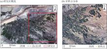
图1
研究区概况及采样点分布"
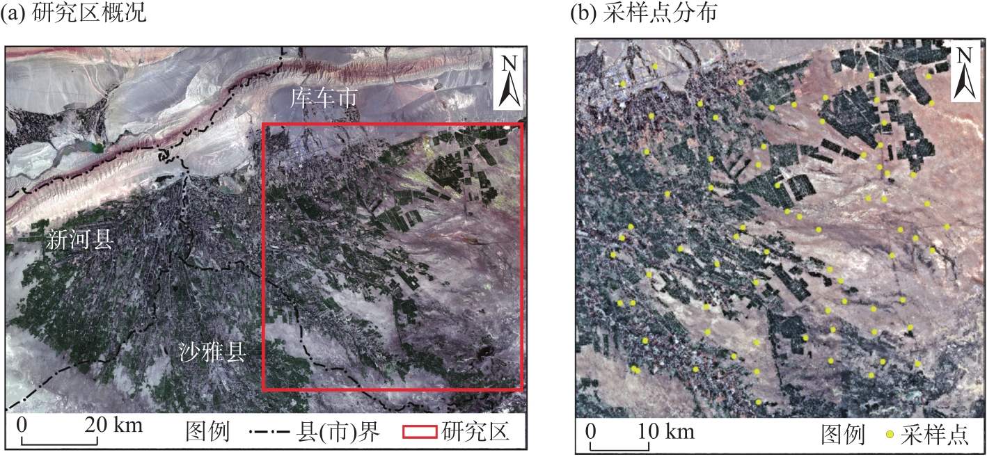

图2
遥感影像处理与特征参量提取流程 注:Y为数据经过归一化之后的结果值;X为像元数据的初始值;Xmin、Xmax分别为目标数据集中的最小值与最大值。"
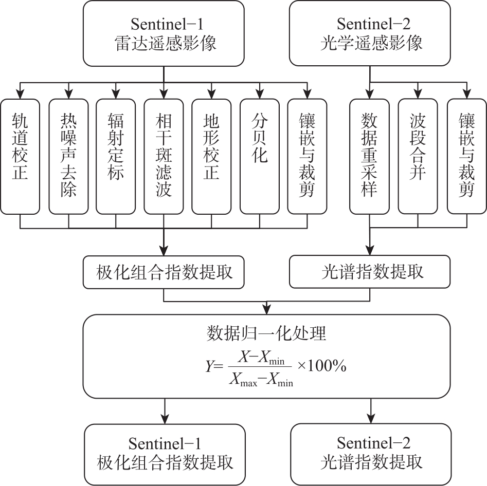
表1
Sentinel-1极化组合指数"
| 极化组合指数 | 参考文献 | 极化组合指数 | 参考文献 |
|---|---|---|---|
| V | [ | V2+H | [ |
| V+H | [ | H2+V | [ |
| H | [ | V2+H2 | [ |
| V-H | [ | (V2+H2)/V | [ |
| (V-H)/(V+H) | [ | (V2+H2)/H | [ |
| H/V | [ | V2-H | [ |
| 10lg(V) | [ | H2-V | [ |
| (V2+H2)/(V2-H2) | [ | V2-H2 | [ |
| 10lg(H) | [ | (V2-H2)/V | [ |
| 10lg(V)+10lg(H) | [ | (V2-H2)/H | [ |
表2
Sentinel-2光谱指数"
| 光谱指数 | 计算公式 | 参考文献 |
|---|---|---|
| 综合光谱响应指数(COSRI) | [ | |
| 归一化差异植被指数(NDVI) | [ | |
| 差值植被指数(DVI) | B8-B4 | [ |
| 绿色大气阻抗植被指数(GARI) | [ | |
| 盐分比指数(SRI) | (B4-B8)×(B3+B8) | [ |
| 强度指数1(Int1) | [ | |
| 强度指数2(Int2) | [ | |
| 归一化差异水体指数(NDWI) | [ | |
| 比值植被指数(RVI) | [ | |
| 归一化差异盐分指数(NDSI) | [ | |
| 盐分指数1(S1) | [ | |
| 盐分指数2(S2) | [ | |
| 盐分指数3(S3) | [ | |
| 盐分指数5(S5) | [ | |
| 盐分指数6(S6) | [ | |
| 土壤调节植被指数(SAVI) | [ | |
| 盐分指数(SI) | [ | |
| 盐分指数1(SI1) | [ | |
| 盐分指数2(SI2) | [ | |
| 盐分指数3(SI3) | [ | |
| 冠层响应盐分指数(CRSI) | [ | |
| 盐分指数7(SI7) | [ |
表3
Sentinel-1极化组合指数相关性统计"
| 极化组合指数 | 相关系数(r) | 极化组合指数 | 相关系数(r) |
|---|---|---|---|
| V | -0.252* | H | -0.482** |
| V+H | -0.432** | V-H | 0.474** |
| V2+H | -0.457** | V2-H | 0.488** |
| H2+V | -0.413** | H2-V | -0.337** |
| V2+H2 | -0.450** | V2-H2 | 0.468** |
| (V2+H2)/V | -0.481** | (V2-H2)/V | 0.465** |
| (V2+H2)/H | -0.209 | (V2-H2)/H | 0.462** |
| (V-H)/(V+H) | 0.439** | (V2+H2)/(V2-H2) | 0.076 |
| H/V | -0.449** | 10lg(V)+10lg(H) | -0.391** |
| 10lg(V) | -0.227* | 10lg(H) | -0.432** |
表4
Sentinel-2光谱指数相关性统计"
| 光谱指数 | 相关系数(r) | 光谱指数 | 相关系数(r) |
|---|---|---|---|
| COSRI | -0.612** | S2 | 0.229* |
| CRSI | -0.622** | S3 | 0.444** |
| DVI | -0.576** | S5 | 0.557** |
| GARI | -0.605** | S6 | -0.420** |
| Int1 | 0.538** | SAVI | -0.576** |
| Int2 | 0.341** | SI | 0.554** |
| NDSI | 0.576** | SI1 | 0.539** |
| NDVI | -0.576** | SI2 | 0.195 |
| NDWI | 0.609** | SI3 | 0.538** |
| RVI | -0.516** | SI7 | -0.420** |
| S1 | 0.224* | SRI | 0.558** |

图3
特征空间散点图 注:V为Sentinel-1影像后向散射系数的VV极化方式;H为Sentinel-1影像后向散射系数的VH极化方式。下同。"
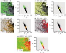
图4
[V2-H]-[H]特征空间盐渍化程度分布"
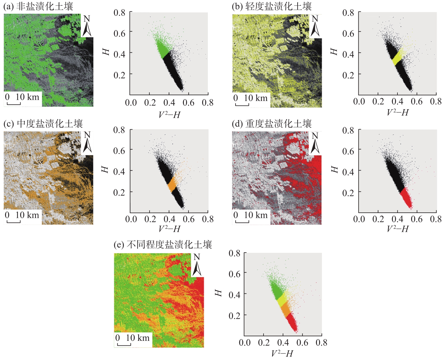
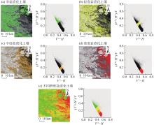
图5
[V2-H]-[(V2+H2)/V]特征空间盐渍化程度分布"
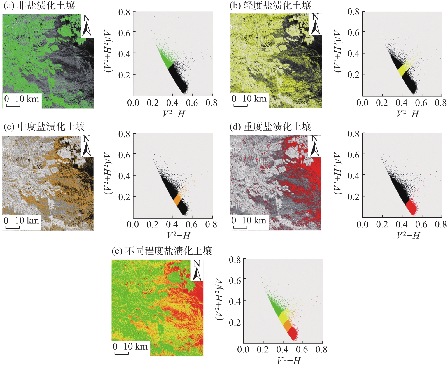

图6
[V2-H]-[V-H]特征空间盐渍化程度分布"
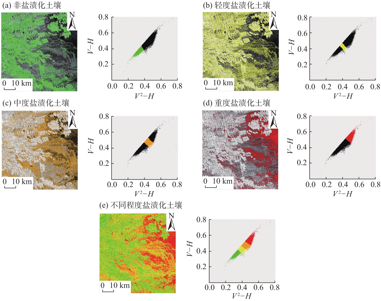
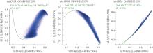
图7
特征空间散点图"
图8
CRSI-COSRI特征空间盐渍化程度分布"
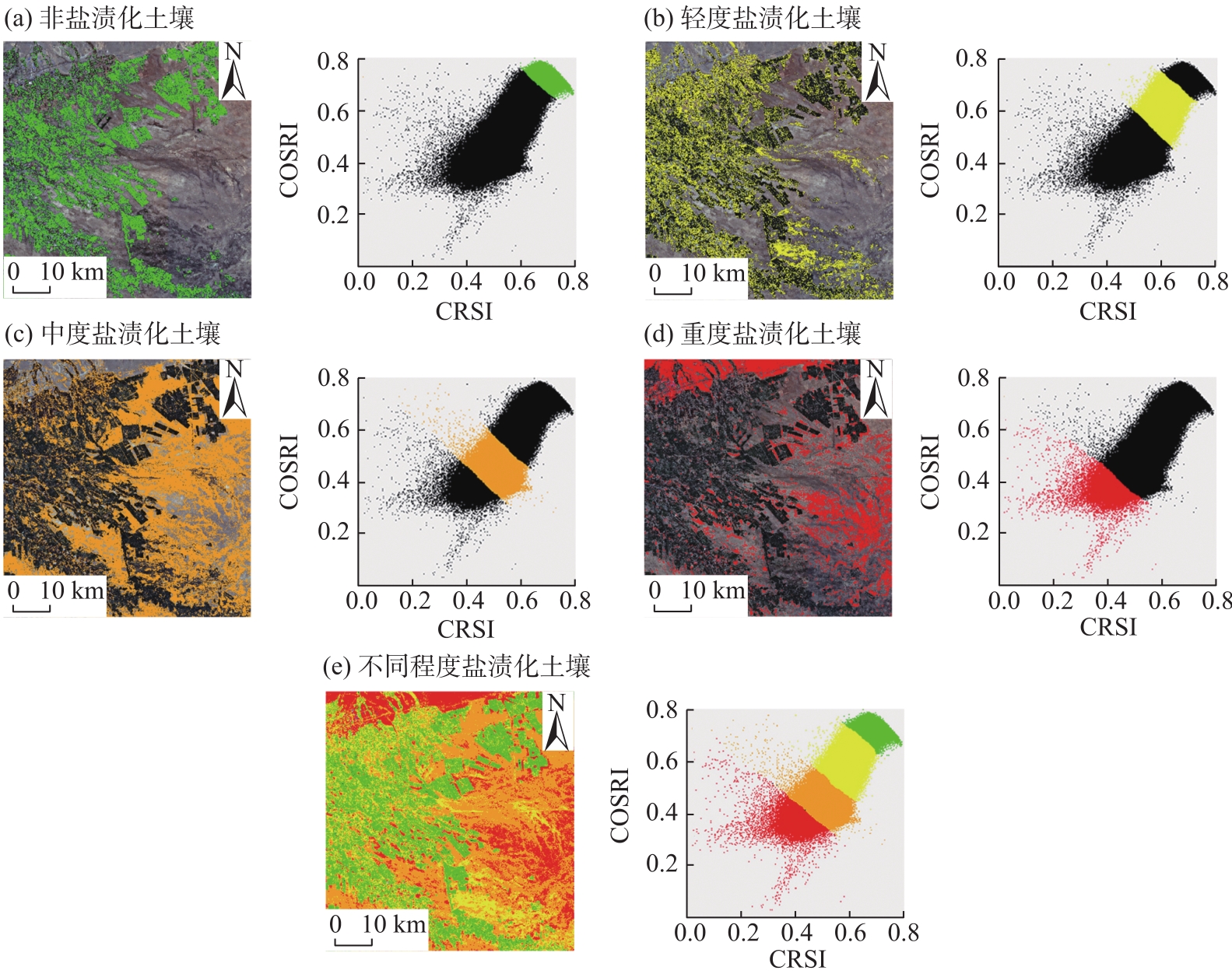
图9
CRSI-NDWI特征空间盐渍化程度分布"
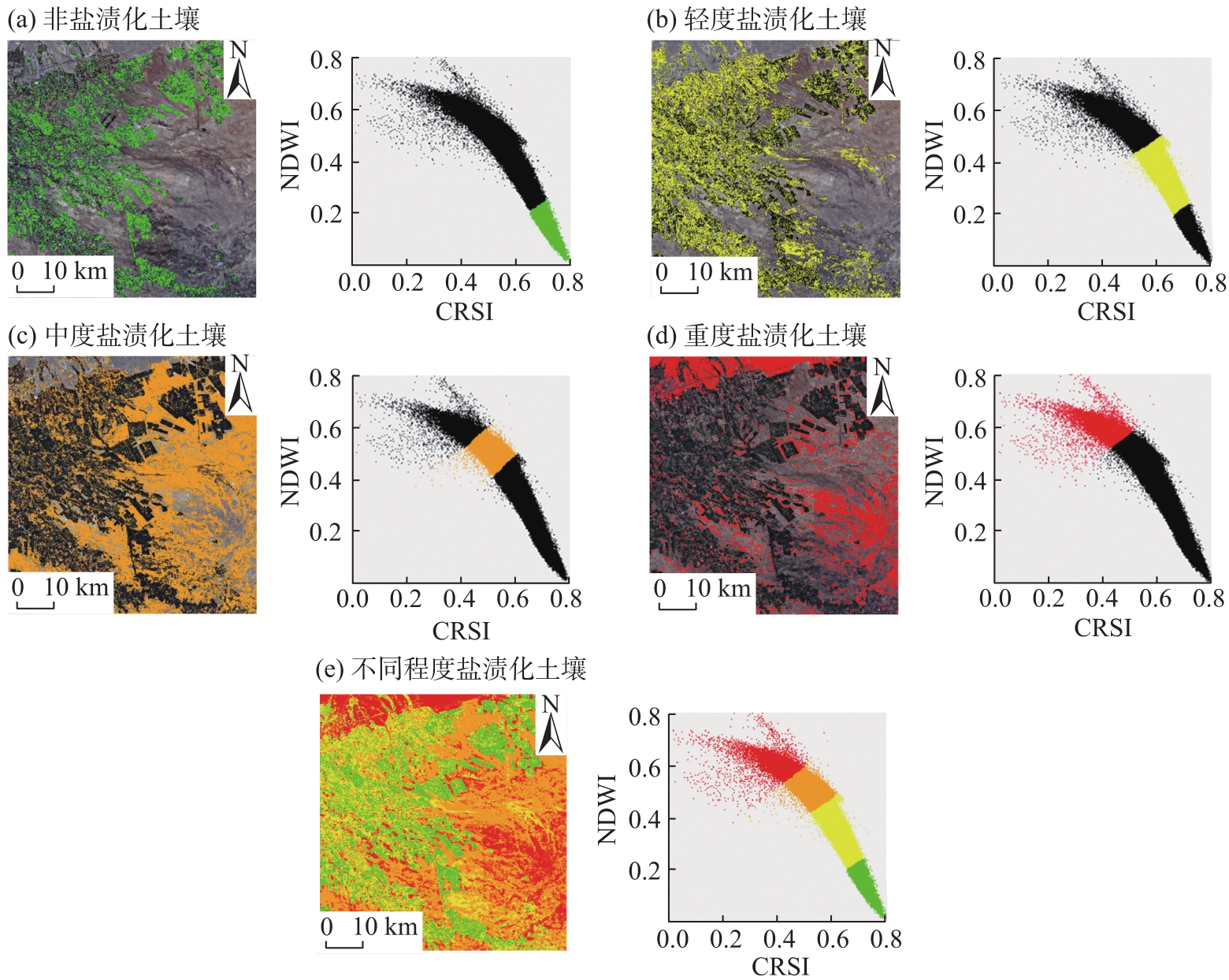
图10
CRSI-GARI特征空间盐渍化程度分布"

表5
特征空间模型反演精度"
| 影像类别 | 模型 | 相关系数 (r) | 决定系数 (R2) |
|---|---|---|---|
| Sentinel-1 | [V2-H]-[H]特征空间模型 | 0.535** | 0.510 |
| [V2-H]-[(V2+H2)/V]特征空间模型 | 0.523** | 0.502 | |
| [V2-H]-[V-H]特征空间模型 | 0.519** | 0.478 | |
| Sentinel-2 | CRSI-COSRI特征空间模型 | 0.639** | 0.670 |
| CRSI-NDWI特征空间模型 | 0.623** | 0.656 | |
| CRSI-GARI特征空间模型 | 0.615** | 0.604 |
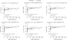
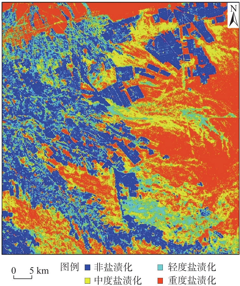
图11
特征空间模型散点图"
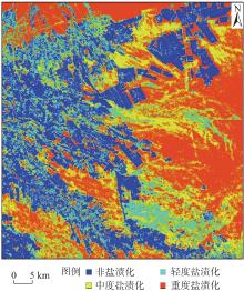
图12
基于最优模型的土壤盐渍化空间分布模拟"
| [1] | 黄晶, 孔亚丽, 徐青山, 等. 盐渍土壤特征及改良措施研究进展[J]. 土壤, 2022, 54(1): 18-23. |
| [Huang Jing, Kong Yali, Xu Qingshan, et al. Progresses for characteristics and amelioration measures of saline soil[J]. Soils, 2022, 54(1): 18-23.] | |
| [2] | 胡炎, 杨帆, 杨宁, 等. 盐碱地资源分析及利用研究展望[J]. 土壤通报, 2023, 54(2): 489-494. |
| [Hu Yan, Yang Fan, Yang Ning, et al. Analysis and prospects of saline-alkali land in China from the perspective of utilization[J]. Chinese Journal of Soil Science, 2023, 54(2): 489-494.] | |
| [3] |
李振亚, 魏伟, 周亮, 等. 中国陆地生态敏感性时空演变特征[J]. 地理学报, 2022, 77(1): 150-163.
doi: 10.11821/dlxb202201011 |
|
[Li Zhenya, Wei Wei, Zhou Liang, et al. Spatio-temporal evolution characteristics of terrestrial ecological sensitivity in China[J]. Acta Geographica Sinica, 2022, 77(1): 150-163.]
doi: 10.11821/dlxb202201011 |
|
| [4] | 董心亮, 王金涛, 田柳, 等. 盐渍化土壤团聚体和微生物与有机质关系研究进展[J]. 中国生态农业学报(中英文), 2023, 31(3): 364-372. |
| [Dong Xinliang, Wang Jintao, Tian Liu, et al. Review of relationships between soil aggregates, microorganisms and soil organic matter in salt-affected soil[J]. Chinese Journal of Eco-Agriculture, 2023, 31(3): 364-372.] | |
| [5] |
耿梦清, 唐夏雨, 李雪草, 等. 基于遥感技术的盐渍土监测研究进展与展望[J]. 世界科技研究与发展, 2025, 47(1): 60-81.
doi: 10.16507/j.issn.1006-6055.2025.01.004 |
| [Geng Mengqing, Tang Xiayu, Li Xuecao, et al. Research progress and prospect of saline soil monitoring based on remote sensing technology[J]. World Sci-Tech R & D, 2025, 47(1): 60-81.] | |
| [6] | 杨劲松, 姚荣江, 王相平, 等. 中国盐渍土研究: 历程、现状与展望[J]. 土壤学报, 2022, 59(1): 10-27. |
| [Yang Jinsong, Yao Rongjiang, Wang Xiangping, et al. Research on salt-affected soils in China: History, status quo and prospect[J]. Acta Pedologica Sinica, 2022, 59(1): 10-27.] | |
| [7] | 刘小京, 郭凯, 封晓辉, 等. 农业高效利用盐碱地资源探讨[J]. 中国生态农业学报(中英文), 2023, 31(3): 345-353. |
| [Liu Xiaojing, Guo Kai, Feng Xiaohui, et al. Discussion on the agricultural efficient utilization of saline-alkali land resources[J]. Chinese Journal of Eco-Agriculture, 2023, 31(3): 345-353.] | |
| [8] |
李小雨, 贾科利, 魏慧敏, 等. 基于随机森林算法的土壤含盐量预测[J]. 干旱区研究, 2023, 40(8): 1258-1267.
doi: 10.13866/j.azr.2023.08.06 |
|
[Li Xiaoyu, Jia Keli, Wei Huimin, et al. Prediction of soil salt content based on the random forest algorithm[J]. Arid Zone Research, 2023, 40(8): 1258-1267.]
doi: 10.13866/j.azr.2023.08.06 |
|
| [9] | Tola D, Satgé F, Pillco Zolá R, et al. Soil salinity mapping of plowed agriculture lands combining radar Sentinel-1 and optical Sentinel-2 with topographic data in machine learning models[J]. Remote Sensing, 2024, 16(18): 3456, doi: 10.3390/rs16183456. |
| [10] |
Liu Y, Qian J, Yue H. Comparison and evaluation of different dryness indices based on vegetation indices-land surface temperature/albedo feature space[J]. Advances in Space Research, 2021, 68(7): 2791-2803.
doi: 10.1016/j.asr.2021.05.007 |
| [11] | 王飞, 丁建丽, 伍漫春. 基于NDVI-SI特征空间的土壤盐渍化遥感模型[J]. 农业工程学报, 2010, 26(8): 168-173. |
| [Wang Fei, Ding Jianli, Wu Manchun. Remote sensing monitoring models of soil salinization based on NDVI-SI feature space[J]. Transactions of the Chinese Society of Agricultural Engineering, 2010, 26(8): 168-173.] | |
| [12] |
Guo B, Yang F. A novel feature space monitoring index of salinisation in the Yellow River delta based on SENTINEL-2B MSI images[J]. Land Degradation & Development, 2022, 33(13): 2303-2316.
doi: 10.1002/ldr.v33.13 |
| [13] | Reheman A, Tashpolat N. Monitoring of soil salinity in the Weiku Oasis based on feature space models with typical parameters derived from Sentinel-2 MSI images[J]. Land, 2025, 14(2): 251, doi: 10.3390/land14020251. |
| [14] |
Nawar S, Buddenbaum H, Hill J, et al. Modeling and mapping of soil salinity with reflectance spectroscopy and Landsat data using two quantitative methods (PLSR and MARS)[J]. Remote Sensing, 2014, 6(11): 10813-10834.
doi: 10.3390/rs61110813 |
| [15] |
肖森天, 依力亚斯江·努尔麦麦提, 努尔比耶·穆合塔尔, 等. 基于光学和雷达多源遥感的于田绿洲土壤盐渍化时空分析[J]. 干旱区研究, 2023, 40(1): 59-68.
doi: 10.13866/j.azr.2023.01.07 |
|
[Xiao Sentian, Nurmemet Ilyas, Muhetaer Nuerbiye, et al. Spatial and temporal analysis of soil salinity in Yutian Oasis by combined optical and radar multi-source remote sensing[J]. Arid Zone Research, 2023, 40(1): 59-68.]
doi: 10.13866/j.azr.2023.01.07 |
|
| [16] | Nurmemet I, Aihaiti A, Aili Y, et al. Quantitative retrieval of soil salinity in arid regions: A radar feature space approach with fully polarimetric SAR data[J]. Sensors, 2025, 25(8): 2512, doi: 10.3390/s25082512. |
| [17] | 代天金, 陈俊英, 郭佳奇, 等. 不同植被覆盖条件下Sentinel-1/2数据融合监测土壤含盐量模型研究[J]. 农业机械学报, 2025, 56(8): 32-41. |
| [Dai Tianjin, Chen Junying, Guo Jiaqi, et al. Monitoring of soil salt content during different growth periods of crops based on Sentinel-1/2[J]. Transactions of the Chinese Society for Agricultural Machinery, 2025, 56(8): 32-41.] | |
| [18] |
马晨, 王宏卫, 谈波, 等. 新疆典型绿洲城乡聚落规模体系特征及空间重构——以渭干河-库车河三角洲绿洲为例[J]. 地理学报, 2022, 77(4): 852-868.
doi: 10.11821/dlxb202204006 |
|
[Ma Chen, Wang Hongwei, Tan Bo, et al. Characteristics and spatial reconstruction of an urban-rural settlement scale system in a typical oasis in Xinjiang: A case study of the Ugan-Kuqa River Delta Oasis[J]. Acta Geographica Sinica, 2022, 77(4): 852-868.]
doi: 10.11821/dlxb202204006 |
|
| [19] |
郑柳娜, 江红南, 孙梦婷. 基于遥感影像的新疆渭干河—库车河三角洲土壤水盐与植被覆盖度的关系[J]. 干旱区研究, 2024, 41(7): 1131-1139.
doi: 10.13866/j.azr.2024.07.05 |
|
[Zheng Liuna, Jiang Hongnan, Sun Mengting. Correlations between soil water content, salinity, and fractional vegetation cover in the Ugan-Kuqa River Delta Oasis of Xinjiang ascertained based on remote sensing images[J]. Arid Zone Research, 2024, 41(7): 1131-1139.]
doi: 10.13866/j.azr.2024.07.05 |
|
| [20] | 刘全明, 成秋明, 王学, 等. 河套灌区土壤盐渍化微波雷达反演[J]. 农业工程学报, 2016, 32(16): 109-114. |
| [Liu Quanming, Cheng Qiuming, Wang Xue, et al. Soil salinity inversion in Hetao Irrigation District using microwave radar[J]. Transactions of the Chinese Society of Agricultural Engineering, 2016, 32(16): 109-114.] | |
| [21] | 彭立, 杨武年, 黄瑾. 川西高原多时相干涉雷达土地覆盖分类研究[J]. 西南大学学报(自然科学版), 2016, 38(5): 125-132. |
| [Peng Li, Yang Wunian, Huang Jin. Study of land cover classification using multi-temporal InSAR data in west plateau of Sichuan[J]. Journal of Southwest University (Natural Science Edition), 2016, 38(5): 125-132.] | |
| [22] | 马驰. 基于Sentinel-1双极化雷达影像的土壤含盐量反演[J]. 农业工程学报, 2018, 34(2): 153-158. |
| [Ma Chi. Quantitative retrieval of soil salt content based on Sentinel-1 dual polarization radar image[J]. Transactions of the Chinese Society of Agricultural Engineering, 2018, 34(2): 153-158.] | |
| [23] | 张智韬, 杜瑜燕, 劳聪聪, 等. 基于雷达遥感的不同深度土壤含盐量反演模型[J]. 农业机械学报, 2020, 51(10): 243-251. |
| [Zhang Zhitao, Du Yuyan, Lao Congcong, et al. Inversion model of soil salt content in different depths based on radar remote sensing[J]. Transactions of the Chinese Society for Agriculture Machinery, 2020, 51(10): 243-251.] | |
| [24] |
Fernández B N, Siebe C, Cram S, et al. Mapping soil salinity using a combined spectral response index for bare soil and vegetation: A case study in the Former Lake Texcoco, Mexico[J]. Journal of Arid Environments, 2006, 65(4): 644-667.
doi: 10.1016/j.jaridenv.2005.08.005 |
| [25] | 王宗辉, 裴宝红. 基于无人机多光谱遥感数据的植被指数玉米估产模型研究[J]. 智慧农业导刊, 2024, 4(4): 1-5. |
| [Wang Zonghui, Pei Baohong. Vegetation index corn yield estimation modeling based on multi-spectral remote sensing data from unmanned aerial vehicles (UAVs)[J]. Journal of Smart Agriculture, 2024, 4(4): 1-5.] | |
| [26] | 陈实, 徐斌, 金云翔, 等. 新疆绿洲农区土壤盐渍化遥感监测方法的比较研究[J]. 绿洲农业科学与工程, 2015, 1(1): 36-41. |
| [Chen Shi, Xu Bin, Jin Yunxiang, et al. Comparative study of remote sensing monitoring methods for soil salinization in oasis agricultural areas of Xinjiang[J]. Oasis Agricultural Science and Engineering, 2015, 1(1): 36-41.] | |
| [27] | 王怡婧, 贾萍萍, 陈睿华, 等. 多源遥感对宁夏干湿季土壤含盐量敏感性分析与定量反演[J]. 生态学杂志, 2023, 42(9): 2286-2295. |
|
[Wang Yijing, Jia Pingping, Chen Ruihua, et al. Sensitivity analysis and quantitative inversion of multi-source remote sensing to soil salt content in dry and wet seasons in Ningxia[J]. Chinese Journal of Ecology, 2023, 42(9): 2286-2295.]
doi: 10.13292/j.1000-4890.202309.006 |
|
| [28] | 周婷, 汪炎, 邹俊, 等. 基于PCA和SVM的遥感影像水体提取方法及验证[J]. 水资源保护, 2023, 39(2): 180-189. |
| [Zhou Ting, Wang Yan, Zou Jun, et al. PCA and SVM-based algorithm of water area extraction from remote sensing images and its verification[J]. Water Resources Protection, 2023, 39(2): 180-189.] | |
| [29] | 敖登, 杨佳慧, 丁维婷, 等. 54种植被指数研究进展综述[J]. 安徽农业科学, 2023, 51(1): 13-21, 28. |
| [Ao Deng, Yang Jiahui, Ding Weiting, et al. Review of 54 vegetation indices[J]. Journal of Anhui Agricultural Sciences, 2023, 51(1): 13-21, 28.] | |
| [30] | 姚远, 丁建丽, 张芳, 等. 基于高光谱指数和电磁感应技术的区域土壤盐渍化监测模型[J]. 光谱学与光谱分析, 2013, 33(6): 1658-1664. |
| [Yao Yuan, Ding Jianli, Zhang Fang, et al. Research on a model for soil salinization monitoring based on hyperspectral index and EM38[J]. Spectroscopy and Spectral Analysis, 2013, 33(6): 1658-1664.] | |
| [31] | 冯娟, 丁建丽, 杨爱霞, 等. 干旱区土壤盐渍化信息遥感建模[J]. 干旱地区农业研究, 2018, 36(1): 266-273. |
| [Feng Juan, Ding Jianli, Yang Aixia, et al. Remote sensing modeling of soil salinization information in arid areas[J]. Agricultural Research in the Arid Areas, 2018, 36(1): 266-273.] | |
| [32] | 王飞, 丁建丽, 魏阳, 等. 基于Landsat系列数据的盐分指数和植被指数对土壤盐度变异性的响应分析——以新疆天山南北典型绿洲为例[J]. 生态学报, 2017, 37(15): 5007-5022. |
| [Wang Fei, Ding Jianli, Wei Yang, et al. Sensitivity analysis of soil salinity and vegetation indices to detect soil salinity variation by using Landsat series images: Applications in different oases in Xinjiang, China[J]. Acta Ecologica Sinica, 2017, 37(15): 5007-5022.] | |
| [33] | 丁建丽, 姚远, 王飞. 基于三维光谱特征空间的干旱区土壤盐渍化遥感定量研究[J]. 土壤学报, 2013, 50(5): 853-861. |
| [Ding Jianli, Yao Yuan, Wang Fei. Quantitative remote sensing of soil salinization in arid regions based on three dimensional spectrum eigen spaces[J]. Acta Pedologica Sinica, 2013, 50(5): 853-861.] | |
| [34] |
刘瑞亮, 贾科利, 李小雨, 等. 组合光学和微波遥感的耕地土壤含盐量反演[J]. 干旱区地理, 2024, 47(3): 433-444.
doi: 10.12118/j.issn.1000-6060.2023.375 |
|
[Liu Ruiliang, Jia Keli, Li Xiaoyu, et al. Inversion of soil salt content by combining optical and microwave remote sensing in cultivated land[J]. Arid Land Geography, 2024, 47(3): 433-444.]
doi: 10.12118/j.issn.1000-6060.2023.375 |
|
| [35] |
吕娜, 郭梦京, 赵馨, 等. 内陆淡水湖博斯腾湖水质遥感反演及时空演变特征[J]. 干旱区地理, 2024, 47(6): 953-966.
doi: 10.12118/j.issn.1000-6060.2023.386 |
|
[Lü Na, Guo Mengjing, Zhao Xin, et al. Remote sensing inversion of water quality and spatiotemporal evolution characteristics of the Bosten Inland Freshwater Lake[J]. Arid Land Geography, 2024, 47(6): 953-966.]
doi: 10.12118/j.issn.1000-6060.2023.386 |
|
| [36] | 毋兆鹏, 王明霞, 赵晓. 基于荒漠化差值指数(DDI)的精河流域荒漠化研究[J]. 水土保持通报, 2014, 34(4): 188-192. |
| [Wu Zhaopeng, Wang Mingxia, Zhao Xiao. A study on desertification based on desertification difference index in Jinghe Watershed[J]. Bulletin of Soil and Water Conservation, 2014, 34(4): 188-192.] | |
| [37] | 朱生堡, 乌尔古丽·托尔逊, 唐光木, 等. 新疆盐碱地变化及其治理措施研究进展[J]. 山东农业科学, 2023, 55(3): 158-165. |
| [Zhu Shengbao, Tuoerxun Wuerguli, Tang Guangmu, et al. Research progress on saline-alkali land changes and its treatment measures in Xinjiang[J]. Shandong Agricultural Sciences, 2023, 55(3): 158-165.] | |
| [38] | 穆耶赛尔·肉孜, 王雪梅. 渭-库绿洲耕层土壤水盐空间分异特征研究[J]. 西北林学院学报, 2021, 36(6): 39-46. |
| [Rouz Muyesaier, Wang Xuemei. Spatial variation characteristics of soil water and salt in cultivated layer in the delta oasis of the Weigan-Kuqa Rivers[J]. Journal of Northwest Forestry University, 2021, 36(6): 39-46.] | |
| [39] | 何宝忠, 丁建丽, 刘博华, 等. 渭库绿洲土壤盐渍化时空变化特征[J]. 林业科学, 2019, 55(9): 185-196. |
| [He Baozhong, Ding Jianli, Liu Bohua, et al. Spatiotemporal variation of soil salinization in Weigan-Kuqa River Delta Oasis[J]. Scientia Silvae Sinicae, 2019, 55(9): 185-196.] | |
| [40] | 陈猷, 申晓晶, 周博, 等. 基于多源遥感宁夏引黄灌区季节性土壤盐分反演模型构建[J]. 水土保持学报, 2025, 39(6): 1-11. |
| [Chen You, Shen Xiaojing, Zhou Bo, et al. Construction of seasonal soil salinity inversion models in Yellow River irrigation area of Ningxia based on multi-source remote sensing[J]. Journal of Soil and Water Conservation, 2025, 39(6): 1-11.] | |
| [41] | 吴雨箫, 陈皓锐, 张宝忠, 等. 基于卫星遥感的内蒙古达拉特旗黄河南岸灌区土壤盐分时空演变分析[J]. 农业机械学报, 2025, 56(8): 42-51, 85. |
| [Wu Yuxiao, Chen Haorui, Zhang Baozhong, et al. Analysis of spatial and temporal evolution of soil salinity in Yellow River south bank irrigation area of Dalate Banner, Inner Mongolia based on satellite remote sensing[J]. Transactions of the Chinese Society for Agricultural Machinery, 2025, 56(8): 42-51, 85.] | |
| [42] | 王二龙, 王建萍, 韩进军, 等. 基于Sentinel-1和Sentinel-2协同反演干旱区地表土壤水分——以格尔木河中下游为例[J]. 盐湖研究, 2022, 30(1): 16-24. |
| [Wang Erlong, Wang Jianping, Han Jinjun, et al. Based on Sentinel-1 and Sentinel-2 synergistic inversion of surface soil moisture in arid areas: A case study of the middle and lower reaches of the Golmud River[J]. Journal of Salt Lake Research, 2022, 30(1): 16-24.] | |
| [43] | 董雨昕, 韩文霆, 崔欣, 等. 基于无人机与Sentinel-2A遥感数据协同的裸土期土壤含盐量反演[J]. 农业机械学报, 2025, 56(6): 434-445. |
| [Dong Yuxin, Han Wenting, Cui Xin, et al. Soil salinity inversion during bare soil period based on collaboration of UAV and Sentinel-2A remote sensing data[J]. Transactions of the Chinese Society for Agricultural Machinery, 2025, 56(6): 434-445.] | |
| [44] |
Zhang J R, Zhang Z T, Chen J Y, et al. Estimating soil salinity with different fractional vegetation cover using remote sensing[J]. Land Degradation & Development, 2021, 32(2): 597-612.
doi: 10.1002/ldr.v32.2 |
| [45] | 张智韬, 贺玉洁, 殷皓原, 等. 基于Sentinel-1/2改进极化指数和纹理特征的土壤含盐量反演模型[J]. 农业机械学报, 2024, 55(1): 175-185. |
| [Zhang Zhitao, He Yujie, Yin Haoyuan, et al. Synergistic estimation of soil salinity based on Sentinel-1/2 improved polarization combination index and texture features[J]. Transactions of the Chinese Society for Agricultural Machinery, 2024, 55(1): 175-185.] |
| [1] | 蒙慧敏, 占车生, 胡实, 林忠辉. 大型灌区土壤水盐运移模拟研究进展[J]. 干旱区地理, 2024, 47(9): 1566-1576. |
| [2] | 谢俊博, 王兴鹏, 何帅, 刘洋, 忠智博, 李妍, 洪国军. 基于光谱指数建模的沙井子灌区土壤盐分反演[J]. 干旱区地理, 2024, 47(7): 1199-1209. |
| [3] | 石聪, 陈礼瀚, 张怡菲, 何帅, 谢海霞. 新疆小海子灌区耕地土壤盐渍化特征研究[J]. 干旱区地理, 2023, 46(8): 1314-1323. |
| [4] | 李科, 丁建丽, 韩礼敬, 葛翔宇, 顾永昇, 周倩, 吕阳霞. 基于PlanetScope影像的典型绿洲土壤盐渍化数字制图[J]. 干旱区地理, 2023, 46(8): 1291-1302. |
| [5] | 蒋磊, 刘小龙, 郭帅, 何亮, 邢建磊, 郭俊杰. 基于Logistic回归分析的土壤盐渍化易发性评价——以新疆南疆塔里木灌区为例[J]. 干旱区地理, 2023, 46(11): 1858-1867. |
| [6] | 赵爽,丁建丽,韩礼敬,黄帅,葛翔宇. 新疆典型盐渍土微波介电特性响应分析与建模[J]. 干旱区地理, 2022, 45(5): 1534-1546. |
| [7] | 代云豪,管瑶,张钦凯,孙峻杰,贺兴宏. 阿拉尔垦区土壤盐渍化遥感监测及时空特征分析[J]. 干旱区地理, 2022, 45(4): 1176-1185. |
| [8] | 赵巧珍,丁建丽,韩礼敬,金晓叶,郝建平. MODIS和Landsat时空融合影像在土壤盐渍化监测中的适用性研究——以渭干河—库车河三角洲绿洲为例[J]. 干旱区地理, 2022, 45(4): 1155-1164. |
| [9] | 王爽, 丁建丽, 王璐, 牛增懿. 基于地表光谱建模的区域土壤盐渍化遥感监测研究[J]. 干旱区地理, 2016, 39(1): 190-198. |
| [10] | 牛增懿, 丁建丽, 李艳华, 王爽, 王璐, 马成霞. 基于高分一号影像的土壤盐渍化信息提取方法[J]. 干旱区地理, 2016, 39(1): 171-181. |
| [11] | 丁建丽,张喆,李鑫,鄢雪英. 中亚土库曼斯坦绿洲土壤盐渍化动态演变评估[J]. 干旱区地理, 2013, 36(4): 571-578. |
| [12] | 乔木, 周生斌, 卢磊, 闫俊杰, 李和平. 近25a来塔里木盆地灌区土壤盐渍化时空变化特点与改良治理对策[J]. 干旱区地理, 2011, 34(4): 604-613. |
| [13] | 姜凌, 李佩成, 胡安焱, 易秀. 干旱区绿洲土壤盐渍化分析评价[J]. 干旱区地理, 2009, 32(2): 234-239. |
|
||