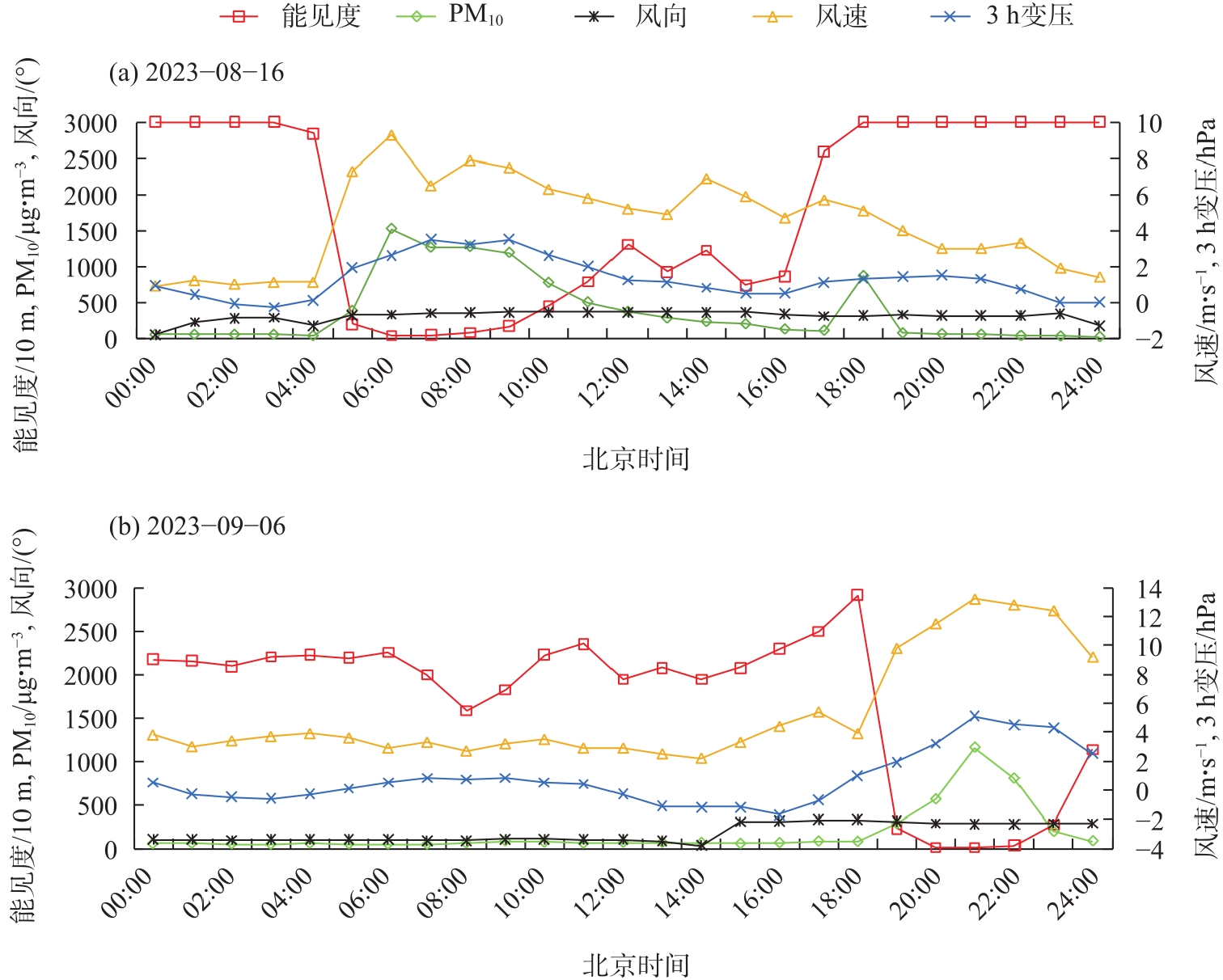
| [1] |
钱莉, 李岩瑛, 杨永龙, 等. 河西走廊东部强沙尘暴分布特征及飑线天气引发强沙尘暴特例分析[J]. 干旱区地理, 2010, 33(1): 29-36.
|
|
[Qian Li, Li Yanying, Yang Yonglong, et al. Distribution characteristics of strong sandstorm and special case analysis of strong sandstorm initiated by squall line in the eastern of Hexi Corridor[J]. Arid Land Geography, 2010, 33(1): 29-36. ]
|
| [2] |
涂爱琴, 王珍珠, 朱庚华, 等. 2021年3月中国北方两次强沙尘天气污染特征[J]. 干旱气象, 2023, 41(4): 607-619.
doi: 10.11755/j.issn.1006-7639(2023)-04-0607
|
|
[Tu Aiqin, Wang Zhenzhu, Zhu Genghua, et al. Pollution characteristies of two strong dust processes in northern China in March 2021[J]. Journal of Arid Meteorology, 2023, 41(4): 607-619. ]
|
| [3] |
钱莉, 姚玉璧, 杨鑫, 等. 河西走廊盛夏一次沙尘暴天气过程成因[J]. 中国沙漠, 2016, 36(2): 458-466.
doi: 10.7522/j.issn.1000-694X.2015.00038
|
|
[Qian Li, Yao Yubi, Yang Xin, et al. An analysis of sandstorm weather process in the Hexi Corridor in summer[J]. Journal of Desert Research, 2016, 36(2): 458-466. ]
doi: 10.7522/j.issn.1000-694X.2015.00038
|
| [4] |
段伯隆, 刘新伟, 郭润霞, 等. “3·15”北方强沙尘暴天气成因分析[J]. 干旱气象, 2021, 39(4): 541-553.
|
|
[Duan Bolong, Liu Xinwei, Guo Runxia, et al. Cause analysis on severe dust storm in northern China on 15 march 2021[J]. Journal of Arid Meteorology, 2021, 39(4): 541-553. ]
|
| [5] |
赵慧华, 罗晓玲, 李岩瑛, 等. 河西走廊东部武威市2023年极端天气气候特征分析[J]. 中南农业科技, 2024, 45(8): 126-128.
|
|
[Zhao Huihua, Luo Xiaoling, Li Yanying, et al. Climate characteristics of extreme weather in 2023 in Wuwei City, eastern Hexi Corridor[J]. South-Central Agricultural Science and Technology, 2024, 45(8): 126-128. ]
|
| [6] |
尹晓惠. 我国沙尘天气研究的最新进展与展望[J]. 中国沙漠, 2009, 29(4): 728-733.
|
|
[Yin Xiaohui. Progress and prospeet of research on sand-dust weather in China[J]. Journal of Desert Research, 2009, 29(4): 728-733. ]
|
| [7] |
马柱国, 符淙斌, 杨庆, 等. 关于我国北方干旱化及其转折性变化[J]. 大气科学, 2018, 42(4): 951-961.
|
|
[Ma Zhuguo, Fu Congbin, Yang Qing, et al. Drying trend in northern China and its shift during 1951—2016[J]. Chinese Journal of Atmospheric Sciences, 2018, 42(4): 951-961. ]
|
| [8] |
李耀辉, 张书余. 我国沙尘暴特征及其与干旱关系的研究进展[J]. 地球科学进展, 2007, 22(11): 1169-1176.
doi: 10.11867/j.issn.1001-8166.2007.11.1169
|
|
[Li Yaohui, Zhang Shuyu. Review of the research on the relationship between sand-dust storm and arid in China[J]. Advance in Earth Science, 2007, 22(11): 1169-1176. ]
|
| [9] |
花丛, 刘超, 张碧辉. 影响北京的两次沙尘过程传输特征对比分析[J]. 中国沙漠, 2019, 39(6): 99-107.
doi: 10.7522/j.issn.1000-694X.2018.00144
|
|
[Hua Cong, Liu Chao, Zhang Bihui. Comparative analysis of transport characteristies of two dust events affecting Beijing[J]. Journal of Desert Research, 2019, 39(6): 99-107. ]
doi: 10.7522/j.issn.1000-694X.2018.00144
|
| [10] |
吴硕秋, 马晓燕. 利用风云四、MODIS及CALIPSO卫星资料分析西北沙尘过程的垂直和水平分布特征[J]. 环境科学学报, 2020, 40(8): 2892-2901.
|
|
[Wu Shuoqiu, Ma Xiaoyan. Analysis of dust verical and horizontal distribution during dust events in nothwest China based on FY-4A, MODIS and CALIPSO satellite data[J]. Acta Scientiae Circumstantiae, 2020, 40(8): 2892-2901. ]
|
| [11] |
叶洽, 郑小慎, 赵尚玉. 2021年中国北部特大沙尘天气的遥感监测与路径分析[J]. 遥感学报, 2023, 27(8): 1821-1833.
|
|
[Ye Qia, Zheng Xiaoshen, Zhao Shangyu. Remote sensing monitoring and transport path analysis of an intense dust weather in northern China in 2021[J]. National Remote Sensing Bulletin, 2023, 27(8): 1821-1833. ]
|
| [12] |
张春燕, 李岩瑛, 马幸蔚, 等. 河西走廊不同强度槽型沙尘暴垂直动量传输特征分析[J]. 地球科学进展, 2022, 37(9): 925-936.
doi: 10.11867/j.issn.1001-8166.2022.052
|
|
[Zhang Chunyan, Li Yanying, Ma Xingwei, et al. Analysis of the vertical momentum transmission characteristics of different intensity trough type sandstomm along the Hexi Coridor[J]. Advances in Earth Science, 2022, 37(9): 925-936. ]
doi: 10.11867/j.issn.1001-8166.2022.052
|
| [13] |
狄潇泓, 刘新伟, 沙宏娥, 等. 河西走廊一次强沙尘暴动力机制分析[J]. 干旱区资源与环境, 2016, 30(8): 145-151.
|
|
[Di Xiaohong, Liu Xinwei, Sha Hong’e, et al. Dynamic mechanism of a severe sandstorm occurred in the Hexi Corridor[J]. Journal of Arid Land Resources and Environment, 2016, 30(8): 145-151. ]
|
| [14] |
王锡稳, 刘治国, 黄玉霞, 等. 河西走廊盛夏一次强沙尘暴天气综合分析[J]. 气象, 2006, 32(7): 102-109.
|
|
[Wang Xiwen, Liu Zhiguo, Huang Yuxia, et al. Integrated analysis of a severe sand-dust storm in Hexi Corridor in summer[J]. Meteorological Journal, 2006, 32(7): 102-109. ]
|
| [15] |
贺沅平, 张云伟, 顾兆林. 特强沙尘暴灾害性天气的特征及触发机制的研究进展和展望[J]. 中国环境科学, 2021, 41(8): 3511-3522.
|
|
[He Yuanping, Zhang Yunwei, Gu Zhaolin. Features, triggering and evolution of very strong sandstorms[J]. China Environmental Science, 2021, 41(8): 3511-3522. ]
|
| [16] |
张春燕, 李岩瑛, 曾婷, 等. 河西走廊东部冬季沙尘暴的典型个例及气候特征分析[J]. 气象, 2019, 45(9): 1227-1237.
|
|
[Zhang Chunyan, Li Yanying, Zeng Ting, et al. Case analysis and climatic characteristics of winter sandstorm over eastern Hexi Corridor[J]. Meteorological Monthly, 2019, 45(9): 1227-1237. ]
|
| [17] |
胡雯婕, 马莉, 吴秀芹, 等. 毛乌素沙地上空沙尘暴的前向轨迹及其影响范围[J]. 北京大学学报(自然科学版), 2021, 57(6): 1161-1171.
|
|
[Hu Wenjie, Ma Li, Wu Xiuqin, et al. Dust storms forward trajectories and influence range over the Mu Us Desert[J]. Acta Scientiarum Naturalium Universitatis Pekinensis, 2021, 57(6): 1161-1171. ]
|
| [18] |
Iraji F, Memarian M H, Joghataei M, et al. Determining the source of dust storms with use of coupling WRF and HYSPLIT models: A case study of Yazd Province in central desert of Iran[J]. Dynamics of Atmospheres and Oceans, 2021, 93: 101197, doi: 10.1016/j.dynatmoce.2020.101197.
|
| [19] |
Lu X, Mao F Y, Pan Z X, et al. Three-dimensional physical and optical characteristics of aerosols over central China from long-term CALIPSO and HYSPLIT data[J]. Remote Sensing, 2018, 10(2): 314, doi: 10.3390/rs10020314.
|
| [20] |
王淦泉, 沈霞. 风云四号辐射成像仪及其数据在卫星气象中的应用[J]. 自然杂志, 2018, 40(1): 1-11.
|
|
[Wang Ganquan, Shen Xia. The FY-4 radiometer imager and the application of its data in the satellite meteorology[J]. Chinese Journal of Nature, 2018, 40(1): 1-11. ]
|
| [21] |
李云. 风云卫星在沙尘天气监测中的业务应用[J]. 卫星应用, 2018(11): 24-28.
|
|
[Li Yun. Operational application of Fengyun satellite in dust weather monitoring[J]. Satellite Applications, 2018(11): 24-28. ]
|
| [22] |
张强, 王胜. 论特强沙尘暴(黑风)的物理特征及其气候效应[J]. 中国沙漠, 2005, 25(5): 675-681.
|
|
[Zhang Qiang, Wang Sheng. On physical characteristics of heavy duststorm and its climatie effect[J]. Journal of Desert Research, 2005, 25(5): 675-681. ]
|
| [23] |
魏倩, 隆霄, 田畅, 等. 民勤一次沙尘暴天气过程的近地层气象要素多尺度特征分析[J]. 干旱区研究, 2018, 35(6): 1352-1362.
|
|
[Wei Qian, Long Xiao, Tian Chang, et al. Multiscale meteorological characteristies during a sandstorm in Minqin[J]. Arid Zone Research, 2018, 35(6): 1352-1362. ]
|
| [24] |
雷正翠, 郑媛媛, 刘银峰, 等. 2018年常州一次罕见持续性雾-霾天气分析[J]. 气象, 2019, 45(8): 1123-1134.
|
|
[Lei Zhengcui, Zheng Yuanyuan, Liu Yinfeng, et al. Causes analyses of a severe continuous fog-haze weather process in Changzhou in 2018[J]. Meteorological Monthly, 2019, 45(8): 1123-1134. ]
|
| [25] |
毛曳, 张恒德, 朱彬. 2016冬季京津冀一次持续重度霾天气过程分析[J]. 环境科学, 2021, 42(8): 3615-3621.
|
|
[Mao Ye, Zhang Hengde, Zhu Bin. Analysis of the continuous heavy pollution process in the winter of 2016 in Beijing, Tianjin, and Hebei[J]. Environmental Science, 2021, 42(8): 3615-3621. ]
|
| [26] |
阿不力米提江·阿布力克木, 李娜, 赵克明, 等. 塔里木盆地一次“东灌”沙尘暴大气边界层特征[J]. 沙漠与绿洲气象, 2019, 13(5): 55-61.
|
|
[Ablikmu Alemitijiang, Li Na, Zhao Keming, et al. Characteristics of atmospheric boundary layer during an east irrigated sandstorm in Tarim Basin[J]. Desert and Oasis Meteorology, 2019, 13(5): 55-61. ]
|
| [27] |
赵瑾, 张春燕, 陈静, 等. 2024年春季河西走廊一次强沙尘暴天气成因及沙尘传输特征分析[J]. 农业灾害研究, 2024, 14(10): 201-203.
|
|
[Zhao Jin, Zhang Chunyan, Chen Jing, et al. Analysis of the causes and sand and dust transport characteristics of a severe sandstorm in the Hexi Corridor in spring 2024[J]. Journal of Agricultural Catastrophology, 2024, 14(10): 201-203. ]
|
| [28] |
费兵强, 吴波, 殷婕, 等. 1964—2020年毛乌素沙地新垦耕地和弃耕地空间格局变化及其对荒漠化的影响[J]. 干旱区地理, 2025, 48(4): 661-672.
doi: 10.12118/j.issn.1000-6060.2024.390
|
|
[Fei Bingqiang, Wu Bo, Yin Jie, et al. Changes in the spatial pattern of newly cultivated and abandoned farmland in the Mu Us Sandy Land from 1964 to 2020 and their impact on desertification[J]. Arid Land Geography, 2025, 48(4): 661-672. ]
doi: 10.12118/j.issn.1000-6060.2024.390
|
| [29] |
王俊秀, 王俊杰, 韩仙桃, 等. 基于多源数据的2021年3月呼和浩特严重沙尘污染天气特征分析[J]. 气象与环境学报, 2023, 39(4): 17-24.
|
|
[Wang Junxiu, Wang Junjie, Han Xiantao, et al. Characterization analysis of the severe dust pollution event in Hohhot in March 2021 based on multi-source data[J]. Journal of Meteorology and Environment, 2023, 39(4): 17-24. ]
|
| [30] |
沈晓玲, 岑璐琳, 章超钦, 等. 一次阵风锋及锋后极端大风的多种型号雷达观测特征分析[J]. 干旱气象, 2025, 43(1): 114-125.
doi: 10.11755/j.issn.1006-7639-2025-01-0114
|
|
[Shen Xiaoling, Cen Lulin, Zhang Chaoqin, et al. Analysis of multi types radar products characteristics of a gust front and the extreme wind after the gust front[J]. Journal of Arid Meteorology, 2025, 43(1): 114-125. ]
|
 ), 李岩瑛1,2(