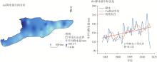
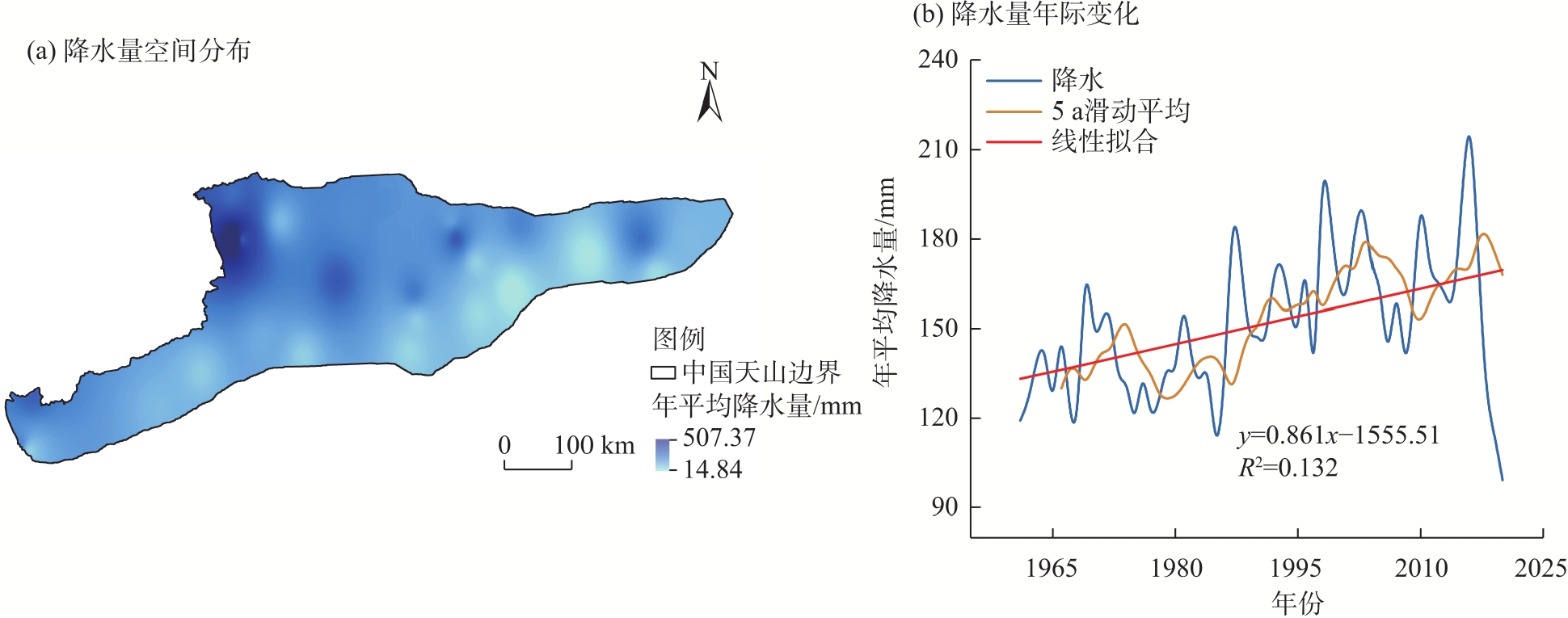
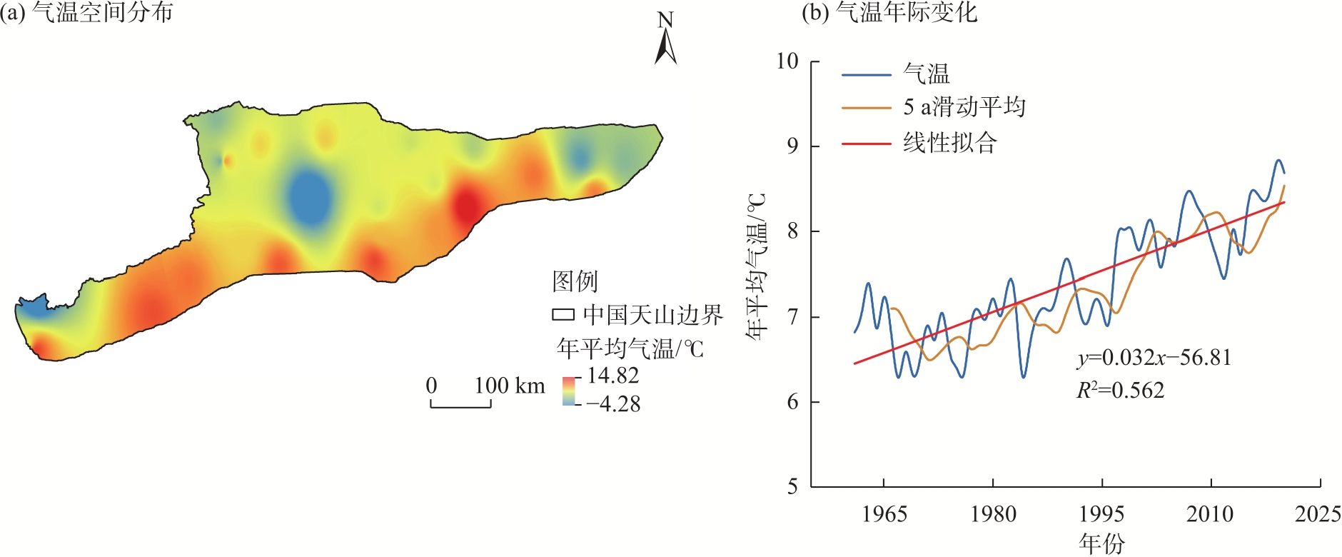
| [1] |
Rezaei E E, Webber H, Asseng S, et al. Climate change impacts on crop yields[J]. Nature Reviews Earth & Environment, 2023, 4(12): 831-846.
|
| [2] |
Chu X L, Lu Z, Wei D, et al. Effects of land use/cover change (LUCC) on the spatiotemporal variability of precipitation and temperature in the Songnen Plain, China[J]. Journal of Integrative Agriculture, 2022, 21(1): 235-248.
doi: 10.1016/S2095-3119(20)63495-5
|
| [3] |
Gao X, Qin S Z. Meteorological disasters, downside risk of grain yield and mitigation effect of high-standard farmland construction policy in China[J]. Climate Risk Management, 2024, 45: 100633, doi: 10.1016/j.crm.2024.100633.
|
| [4] |
Kamalian L, Li H H, Poo M C, et al. Analysis of the impact of climate-driven extreme weather events (EWEs) on the UK train delays: A data-driven BN approach[J]. Reliability Engineering & System Safety, 2025, 262: 111189, doi: 10.1016/j.ress.2025.111189.
|
| [5] |
Chen J, Liu Y J, Pan T, et al. Global socioeconomic exposure of heat extremes under climate change[J]. Journal of Cleaner Production, 2020, 277: 123275, doi: 10.1016/j.jclepro.2020.123275.
|
| [6] |
Joseph J E, Rao K P, Swai E, et al. How beneficial are seasonal climate forecasts for climate risk management? An appraisal for crop production in Tanzania[J]. Climate Risk Management, 2025, 47: 100686, doi: 10.1016/j.crm.2024.100686.
|
| [7] |
Saito N. Mainstreaming climate change adaptation in least developed countries in south and southeast Asia[J]. Mitigation and Adaptation Strategies for Global Change, 2013, 18: 825-849.
doi: 10.1007/s11027-012-9392-4
|
| [8] |
Ren X H, Li Y Y, Shahbaz M, et al. Climate risk and corporate environmental performance: Empirical evidence from China[J]. Sustainable Production and Consumption, 2022, 30: 467-477.
doi: 10.1016/j.spc.2021.12.023
|
| [9] |
Karl T R, Knight R W, Easterling D R, et al. Indices of climate change for the United States[J]. Bulletin of the American Meteorological Society, 1996, 77(2): 279-292.
doi: 10.1175/1520-0477(1996)077<0279:IOCCFT>2.0.CO;2
|
| [10] |
Gleason K L, Lawrimore J H, Levinson D H, et al. A revised US climate extremes index[J]. Journal of Climate, 2008, 21: 2124-2137.
doi: 10.1175/2007JCLI1883.1
|
| [11] |
Hansen J, Sato M, Glascoe J, et al. A common-sense climate index: Is climate changing noticeably?[J]. Proceedings of the National Academy of Sciences, 1998, 95(8): 4113-4120.
doi: 10.1073/pnas.95.8.4113
|
| [12] |
Burck J, Marten F, Bals C, et al. The climate change performance index: Results 2015[M]. Berlin: Germanwatch Eingetragener Verein, 2014: 32-35.
|
| [13] |
陈海山, 张耀存, 张文君, 等. 中国极端天气气候研究——“地球系统与全球变化”重点专项项目2024年度最新进展[J]. 大气科学学报, 2025, 48(2): 177-206.
|
|
[Chen Haishan, Zhang Yaocun, Zhang Wenjun, et al. Research on weather and climate extremes over China: 2024 progress of the national key R&D program of China for earth system and global change[J]. Transactions of Atmospheric Sciences, 2025, 48(2): 177-206. ]
|
| [14] |
刘苇航, 叶涛, 史培军, 等. 气候变化对粮食生产风险的影响研究进展[J]. 自然灾害学报, 2022, 31(4): 1-11.
|
|
[Liu Weihang, Ye Tao, Shi Peijun, et al. Advances in the study of climate change impact on crop producing risk[J]. Journal of Natural Disasters, 2022, 31(4): 1-11. ]
|
| [15] |
王岩, 王昊, 崔鹏, 等. 气候变化的灾害效应与科学挑战[J]. 科学通报, 2024, 69(2): 286-300.
|
|
[Wang Yan, Wang Hao, Cui Peng, et al. Disaster effects of climate change and the associated scientific challenges[J]. Chinese Science Bulletin, 2024, 69(2): 286-300. ]
|
| [16] |
Bousfield C G, Morton O, Edwards D P. Climate change will exacerbate land conflict between agriculture and timber production[J]. Nature Climate Change, 2024, 14(10): 1071-1077.
doi: 10.1038/s41558-024-02113-z
|
| [17] |
张博, 李雪梅, 秦启勇. 中国天山积雪物候演变及驱动因素辨析[J]. 遥感技术与应用, 2022, 37(6): 1350-1360.
doi: 10.11873/j.issn.1004-0323.2022.6.1350
|
|
[Zhang Bo, Li Xuemei, Qin Qiyong. Evolution and driving factors of snow phenology in the Chinese Tianshan Mountainous Region[J]. Remote Sensing Technology and Application, 2022, 37(6): 1350-1360. ]
|
| [18] |
朱淑珍, 黄法融, 冯挺, 等. 1979—2020年天山地区积雪量估算及其特征分析[J]. 冰川冻土, 2022, 44(3): 984-997.
doi: 10.7522/j.issn.1000-0240.2022.0093
|
|
[Zhu Shuzhen, Huang Farong, Feng Ting, et al. Estimation of snow mass and its distribution characteristics from 1979 to 2020 in Tianshan Mountains, China[J]. Journal of Glaciology and Geocryology, 2022, 44(3): 984-997. ]
doi: 10.7522/j.issn.1000-0240.2022.0093
|
| [19] |
蔡兴冉, 李忠勤, 张慧, 等. 中国天山冰川变化脆弱性研究[J]. 地理学报, 2021, 76(9): 2253-2268.
doi: 10.11821/dlxb202109015
|
|
[Cai Xingran, Li Zhongqin, Zhang Hui, et al. Vulnerability of glacier change in Chinese Tianshan Mountains[J]. Acta Geographica Sinica, 2021, 76(9): 2253-2268. ]
doi: 10.11821/dlxb202109015
|
| [20] |
姬盼盼, 高敏华, 杨晓东. 中国西北部干旱区NPP驱动力分析——以新疆伊犁河谷和天山山脉部分区域为例[J]. 生态学报, 2019, 39(8): 2995-3006.
|
|
[Ji Panpan, Gao Minhua, Yang Xiaodong. Analysis of NPP driving force in an arid region of northwest China: A case study in Yili Valley and parts of Tianshan Mountains, Xinjiang, China[J]. Acta Ecologica Sinica, 2019, 39(8): 2995-3006. ]
|
| [21] |
秦艳, 丁建丽, 赵求东, 等. 2001—2015年天山山区积雪时空变化及其与温度和降水的关系[J]. 冰川冻土, 2018, 40(2): 249-260.
|
|
[Qin Yan, Ding Jianli, Zhao Qiudong, et al. Spatial-temporal variation of snow cover in the Tianshan Mountains from 2001 to 2015, and its relation to temperature and precipitation[J]. Journal of Glaciology and Geocryology, 2018, 40(2): 249-260. ]
doi: 10.7522/j.issn.1000-0240.2018.0029
|
| [22] |
李雪梅. 中国天山气候变化及其影响研究[M]. 北京: 电子工业出版社, 2021: 25-35.
|
|
[Li Xuemei. Study on climate change and its impacts in Tianshan Mountains, China[M]. Beijing: Electronic Industry Press, 2021: 25-35 ]
|
| [23] |
杨雪雯, 王宁练, 梁倩, 等. 近60 a天山北坡冰川变化研究[J]. 干旱区地理, 2023, 46(7): 1073-1083.
doi: 10.12118/j.issn.1000-6060.2022.509
|
|
[Yang Xuewen, Wang Ninglian, Liang Qian, et al. Glacier changes on the north slope of Tianshan Mountains in recent 60 years[J]. Arid Land Geography, 2023, 46(7): 1073-1083. ]
doi: 10.12118/j.issn.1000-6060.2022.509
|
| [24] |
Ning B Y, Yang X M, Chang L. Changes of temperature and precipitation extremes in Hengduan Mountains, Qinghai-Tibet Plateau in 1961—2008[J]. Chinese Geographical Science, 2012, 22: 422-436.
doi: 10.1007/s11769-012-0549-6
|
| [25] |
周天军, 邹立维, 陈晓龙. 第六次国际耦合模式比较计划(CMIP6)评述[J]. 气候变化研究进展, 2019, 15(5): 445-456.
|
|
[Zhou Tianjun, Zou Liwei, Chen Xiaolong. Commentary on the Coupled Model Intercomparison Project Phase 6 (CMIP6)[J]. Climate Change Research, 2019, 15(5): 445-456. ]
|
| [26] |
吴金华, 盛芝露, 杜加强, 等. 1956—2017年东北地区气温和降水的时空变化特征[J]. 水土保持研究, 2021, 28(3): 340-347.
|
|
[Wu Jinhua, Sheng Zhilu, Du Jiaqiang, et al. Spatiotemporal change patterns of temperature and precipitation in northeast China from 1956 to 2017[J]. Research of Soil and Water Conservation, 2021, 28(3): 340-347. ]
|
| [27] |
Su B D, Huang J L, Mondal S K, et al. Insight from CMIP6 SSP-RCP scenarios for future drought characteristics in China[J]. Atmospheric Research, 2021, 250: 105375, doi: 10.1016/j.atmosres.2020.105375.
|
| [28] |
张晓璐, 王晓欣, 华丽娟, 等. 新疆温度和降水变化的CMIP6模式预估[J]. 大气科学, 2023, 47(2): 387-398.
|
|
[Zhang Xiaolu, Wang Xiaoxin, Hua Lijuan, et al. Projections of temperature and precipitation over Xinjiang based on CMIP6 models[J]. Chinese Journal of Atmospheric Sciences, 2023, 47(2): 387-398. ]
|
| [29] |
Tirivarombo S, Osupile D, Eliasson P. Drought monitoring and analysis: Standardised precipitation evapotranspiration index (SPEI) and standardised precipitation index (SPI)[J]. Physics and Chemistry of the Earth, Parts A/B/C, 2018, 106: 1-10.
doi: 10.1016/j.pce.2018.07.001
|
| [30] |
唐敏, 张勃, 张耀宗, 等. 基于SPEI和SPI指数的青海省东部农业区春夏气象干旱特征的评估[J]. 自然资源学报, 2017, 32(6): 1029-1042.
doi: 10.11849/zrzyxb.20160584
|
|
[Tang Min, Zhang Bo, Zhang Yaozong, et al. Assessment of spring and summer meteorological droughts based on SPEI and SPI in eastern agricultural region of Qinghai Province[J]. Journal of Natural Resources, 2017, 32(6): 1029-1042. ]
doi: 10.11849/zrzyxb.20160584
|
| [31] |
Yin H, Sun Y. Detection of anthropogenic influence on fixed threshold indices of extreme temperature[J]. Journal of Climate, 2018, 31(16): 6341-6352.
doi: 10.1175/JCLI-D-17-0853.1
|
| [32] |
Li C, Zwiers F, Zhang X B, et al. Changes in annual extremes of daily temperature and precipitation in CMIP6 models[J]. Journal of Climate, 2021, 34(9): 3441-3460.
doi: 10.1175/JCLI-D-19-1013.1
|
| [33] |
贾妮娅·叶力肯, 侯建楠, 刘思博. 近30 a新疆地州市旅游气候舒适度时空特征分析[J]. 干旱区地理, 2025, 48(2): 212-222.
doi: 10.12118/j.issn.1000-6060.2024.086
|
|
[Yerken Jianiya, Hou Jiannan, Liu Sibo. Spatio-temporal characterization of tourism climate comfort in Xinjiang prefectures and cities in the last 30 years[J]. Arid Land Geography, 2025, 48(2): 212-222. ]
doi: 10.12118/j.issn.1000-6060.2024.086
|
| [34] |
Wang R, Zhu Q K, Ma H. Changes in freezing and thawing indices over the source region of the Yellow River from 1980 to 2014[J]. Journal of Forestry Research, 2019, 30(1): 257-268.
doi: 10.1007/s11676-017-0589-y
|
| [35] |
谢捷, 刘玮, 徐月顺, 等. 基于AHP-熵权法的西宁地区汛期暴雨灾害风险评估[J]. 自然灾害学报, 2022, 31(3): 60-74.
|
|
[Xie Jie, Liu Wei, Xu Yueshun, et al. Rainstorm disaster risk assessment in Xining area in rainy season based on the AHP weight method and entropy weight method[J]. Journal of Natural Disasters, 2022, 31(3): 60-74. ]
|
| [36] |
Chen F X, Li Y R, Liu Y S. Impact assessment and driving mechanisms of grading and weight distribution methods on spatial zoning[J]. Applied Geography, 2025, 184: 103758, doi: 10.1016/j.apgeog.2025.103758.
|
| [37] |
冯波, 孟宪红, 杨显玉, 等. 第六次国际耦合模式比较计划(CMIP6)中青藏高原气温和降水的适用性评估及极端气候事件变化预估[J]. 高原气象, 2025, 44(2): 265-278.
doi: 10.7522/j.issn.1000-0534.2024.00068
|
|
[Feng Bo, Meng Xianhong, Yang Xianyu, et al. Temperature and precipitation assessment and extreme climate events prediction based on the Coupled Model Intercomparison Project Phase 6 over the Qinghai-Xizang Plateau[J]. Plateau Meteorology, 2025, 44(2): 265-278. ]
doi: 10.7522/j.issn.1000-0534.2024.00068
|
| [38] |
Zhou Z L, Zhang L P, Chen J, et al. Projecting global drought risk under various SSP-RCP scenarios[J]. Earth’s Future, 2023, 11(5): e2022EF003420, doi: 10.1029/2022EF003420.
|
| [39] |
Chen W Y, Lu X C, Yuan D H, et al. Global PM2.5prediction and associated mortality to 2100 under different climate change scenarios[J]. Environmental Science & Technology, 2023, 57(27): 10039-10052.
doi: 10.1021/acs.est.3c03804
|
| [40] |
Chen Y T, Liu A B, Cheng X. Quantifying economic impacts of climate change under nine future emission scenarios within CMIP6[J]. Science of the Total Environment, 2020, 703: 134950, doi: 10.1016/j.scitotenv.2019.134950.
|
| [41] |
Zhu H H, Jiang Z H, Li L. Projection of climate extremes in China, an incremental exercise from CMIP5 to CMIP6[J]. Science Bulletin, 2021, 66(24): 2528-2537.
doi: 10.1016/j.scib.2021.07.026
pmid: 36654212
|
 ), 李雪梅1,2,3(