干旱区地理 ›› 2024, Vol. 47 ›› Issue (4): 634-647.doi: 10.12118/j.issn.1000-6060.2023.274
付玮1( ), 夏文浩1, 樊童生2, 邹贞1, 霍瑜1()
收稿日期:2023-06-11
修回日期:2023-10-24
出版日期:2024-04-25
发布日期:2024-05-17
通讯作者:
霍瑜(1982-),女,教授,博士,主要从事区域经济研究. E-mail: huoyu050301@163.com作者简介:付玮(1999-),女,硕士研究生,主要从事资源与环境经济研究. E-mail: m18799927150@163.com
基金资助:
FU Wei1(), XIA Wenhao1, FAN Tongsheng2, ZOU Zhen1, HUO Yu1()
Received:2023-06-11
Revised:2023-10-24
Published:2024-04-25
Online:2024-05-17
摘要:
土地利用方式是引起陆地生态系统碳储量变化的重要因素,对维持碳储量水平稳定有着关键作用。通过利用耦合的PLUS-InVEST模型评估与预测塔里木河流域1980—2020年土地利用与碳储量变化情况,设置自然发展、生态保护、耕地保护和城镇发展4种场景,分情景预测2030年研究区土地利用及碳储量的变化趋势,在此基础上探究土地利用变化对碳储量的影响。结果表明:(1) 40 a间塔里木河流域耕地、建设用地与未利用地面积显著增加,林地、草地和水域面积减少。(2) 40 a间1980—2020年碳储量总体呈上升趋势,总体增加了22.66×10⁶ t,碳储量增加区域主要分布在塔里木河干流及其分支上。未利用地和草地是塔里木河流域主要的碳库,占碳储量总量的24.77%和19.37%。(3) 情景预测发现2020年后碳储量流失量较大且流失速度逐渐较加快,碳储量减少区域主要分布在研究区的中西南部,未来草地向未利用地及林地向草地的转移均是碳储量流失主要原因,4种情景下分别减少了0.0475×10⁸ t、0.0051×10⁸ t、0.0285×10⁸ t及0.0473×10⁸ t。(4) 耕地向林地、草地向林地、水域向草地及未利用地、未利用地向耕地及草地的转出都有利于碳储存。因此,在未来规划中,应耕地保护和生态保护相结合,在控制建设用地向外扩张的同时保证当地经济增长,提高碳储量水平,为实现“双碳”目标蓄力。
付玮, 夏文浩, 樊童生, 邹贞, 霍瑜. 塔里木河流域生态系统碳储量的情景预测分析[J]. 干旱区地理, 2024, 47(4): 634-647.
FU Wei, XIA Wenhao, FAN Tongsheng, ZOU Zhen, HUO Yu. Scenario projection analysis of ecosystem carbon stocks in the Tarim River Basin[J]. Arid Land Geography, 2024, 47(4): 634-647.
图1
塔里木河流域示意图"
表1
数据及来源"
| 类型 | 名称 | 分辨率/m | 数据来源 |
|---|---|---|---|
| 基础数据 | 土地利用数据 | 30 | 中国科学院资源环境科学与数据中心( |
| 自然条件 | 土壤类型 | 1000 | HWSD世界土壤数据库( |
| 年平均气温 | 1000 | 中国气象数据网(htpp://www.nmic.cn) 中国气象数据网(htpp://www.nmic.cn) | |
| 年降水量 | 1000 | ||
| DEM | 30 | 地理空间数据云( | |
| 坡度 | 30 | 对DEM进行坡度分析 | |
| 社会经济 | 人口 | 1000 | 中国科学院资源环境科学与数据中心( 中国科学院资源环境科学与数据中心( |
| GDP | 1000 | ||
| 交通区位 | 距一级道路距离 | 30 30 30 30 30 30 30 | OpenstreetMap( OpenstreetMap( OpenstreetMap( OpenstreetMap( OpenstreetMap( |
| 距二级道路距离 | |||
| 距三级道路距离 | |||
| 距高速公路距离 | |||
| 距铁路距离 | |||
| 距火车站距离 | 国家基础地理信息中心( 国家基础地理信息中心( | ||
| 邻近城市驻地距离 |
表2
土地利用碳密度"
| 土地利用类型 | 地上碳密度 | 地下碳密度 | 土壤碳密度 | 死亡有机物碳密度 | 参考文献 |
|---|---|---|---|---|---|
| 耕地 | 3.4705 | 4.1202 | 86.2150 | 1.24 | 王绮等[ |
| 林地 | 36.9664 | 10.9131 | 121.3471 | 2.48 | 颜安[ |
| 草地 | 0.5839 | 5.1317 | 85.0168 | 0.22 | 周圣杰[ |
| 水域 | 0.7648 | 0.5428 | 0.0000 | 0.00 | 颜安[ |
| 建设用地 | 1.8833 | 1.7352 | 0.0000 | 0.00 | 周圣杰[ |
| 未利用地 | 0.5428 | 1.0362 | 43.3855 | 0.00 | 颜安[ |
表3
多情景模拟下土地利用转换成本矩阵"
| 情景 | 土地利用类型 | 耕地 | 林地 | 草地 | 水域 | 建设用地 | 未利用地 |
|---|---|---|---|---|---|---|---|
| 自然增长 | 耕地 | 1 | 1 | 1 | 1 | 1 | 1 |
| 林地 | 1 | 1 | 1 | 1 | 1 | 1 | |
| 草地 | 1 | 1 | 1 | 1 | 1 | 1 | |
| 水域 | 1 | 1 | 1 | 1 | 1 | 1 | |
| 建设用地 | 0 | 0 | 0 | 0 | 1 | 0 | |
| 未利用地 | 1 | 1 | 1 | 1 | 1 | 1 | |
| 耕地保护 | 耕地 | 1 | 0 | 0 | 0 | 0 | 0 |
| 林地 | 1 | 1 | 1 | 0 | 1 | 1 | |
| 草地 | 1 | 1 | 1 | 1 | 1 | 1 | |
| 水域 | 1 | 0 | 1 | 1 | 1 | 1 | |
| 建设用地 | 0 | 0 | 0 | 0 | 1 | 0 | |
| 未利用地 | 1 | 1 | 1 | 1 | 1 | 1 | |
| 生态保护 | 耕地 | 1 | 1 | 1 | 1 | 1 | 1 |
| 林地 | 0 | 1 | 0 | 0 | 0 | 0 | |
| 草地 | 0 | 1 | 1 | 1 | 0 | 0 | |
| 水域 | 0 | 0 | 0 | 1 | 0 | 0 | |
| 建设用地 | 0 | 0 | 0 | 0 | 1 | 0 | |
| 未利用地 | 1 | 1 | 1 | 1 | 1 | 1 | |
| 城镇发展 | 耕地 | 1 | 0 | 0 | 0 | 1 | 0 |
| 林地 | 1 | 1 | 1 | 0 | 1 | 1 | |
| 草地 | 1 | 1 | 1 | 1 | 1 | 1 | |
| 水域 | 1 | 1 | 1 | 1 | 0 | 1 | |
| 建设用地 | 0 | 0 | 0 | 0 | 1 | 0 | |
| 未利用地 | 1 | 1 | 1 | 0 | 1 | 1 |

图2
1980—2020年土地利用分布"
图3
1980—2020年土地利用落势、涨势图"
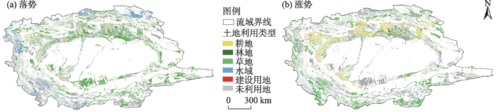
表4
1980—2020年土地利用面积"
| 土地利用类型 | 1980年 | 1990年 | 2000年 | 2010年 | 2020年 |
|---|---|---|---|---|---|
| 耕地 | 24541.47 | 24531.84 | 26750.16 | 35998.74 | 42418.44 |
| 林地 | 12886.38 | 12911.49 | 13546.80 | 12912.57 | 12703.50 |
| 草地 | 254001.87 | 254204.28 | 246313.89 | 233091.90 | 227369.97 |
| 水域 | 36360.81 | 36106.74 | 36823.77 | 21688.11 | 21978.72 |
| 建设用地 | 1517.13 | 1555.38 | 1497.15 | 3628.89 | 2689.92 |
| 未利用地 | 565992.18 | 565990.11 | 570368.07 | 587979.63 | 588139.29 |
表5
1980—2020年土地利用动态度"
| 土地利 用类型 | 1980— 1990年 | 1990— 2000年 | 2000— 2010年 | 2010— 2020年 |
|---|---|---|---|---|
| 耕地 | -0.0039 | 0.9043 | 3.4574 | 1.7833 |
| 林地 | 0.0195 | 0.4921 | -0.4682 | -0.1619 |
| 草地 | 0.0080 | -0.3104 | -0.5368 | -0.2455 |
| 水域 | -0.0699 | 0.1986 | -4.1103 | 0.1340 |
| 建设用地 | 0.2521 | -0.3744 | 14.2387 | -2.5875 |
| 未利用地 | 0.0000 | 0.0774 | 0.3088 | 0.0027 |

图4
1980—2020年塔里木河流域土地利用转移"
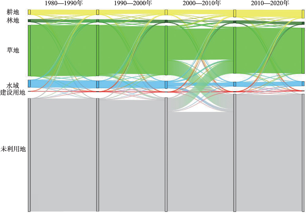
表6
1980—2020年土地利用转移矩阵"
| 1980年 | 2020年 | 转出 | ||||||
|---|---|---|---|---|---|---|---|---|
| 耕地 | 林地 | 草地 | 水域 | 建设用地 | 未利用地 | 总和 | ||
| 耕地 | 20001.96 | 1044.63 | 1494.63 | 206.73 | 1318.68 | 474.84 | 24541.47 | 4539.51 |
| 林地 | 1865.34 | 3848.31 | 5432.76 | 259.11 | 58.14 | 1422.72 | 12886.38 | 9038.07 |
| 草地 | 14557.77 | 6331.50 | 152400.24 | 2686.14 | 328.05 | 77698.17 | 254001.87 | 101601.63 |
| 水域 | 418.23 | 222.03 | 7221.06 | 14606.46 | 9.00 | 13884.03 | 36360.81 | 21754.35 |
| 建设用地 | 935.55 | 90.63 | 62.37 | 8.73 | 391.14 | 28.71 | 1517.13 | 581.58 |
| 未利用地 | 4639.59 | 1166.40 | 60758.91 | 4211.55 | 584.91 | 494630.82 | 565992.18 | 71361.36 |
| 总和 | 42418.44 | 12703.50 | 227369.97 | 21978.72 | 2689.92 | 588139.29 | 895299.84 | - |
| 转入 | 22416.48 | 8855.19 | 74969.73 | 7372.26 | 2298.78 | 93508.47 | - | 209148.70 |
表7
2030年多情景下土地利用面积"
| 土地利 用类型 | 情景 | |||
|---|---|---|---|---|
| 自然发展 | 耕地保护 | 生态保护 | 城镇发展 | |
| 耕地 | 47615.40 | 48078.45 | 40689.54 | 47617.20 |
| 林地 | 12510.36 | 12510.36 | 13342.32 | 12510.36 |
| 草地 | 221893.29 | 221893.20 | 227759.58 | 221893.29 |
| 水域 | 22255.11 | 22255.11 | 22255.11 | 22255.11 |
| 建设用地 | 3158.91 | 2695.95 | 3386.52 | 3157.11 |
| 未利用地 | 587866.77 | 587866.77 | 587866.77 | 587866.77 |

图5
2030年多情景下土地利用分布"
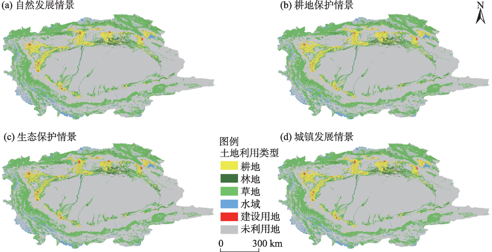
表8
1980—2030年土地利用碳储量"
| 年份 | 耕地 | 林地 | 草地 | 水域 | 建设用地 | 未利用地 | 总计 |
|---|---|---|---|---|---|---|---|
| 1980年 | 2.3326 | 2.2127 | 23.1022 | 0.0475 | 0.0055 | 25.4497 | 53.1502 |
| 1990年 | 2.3316 | 2.2170 | 23.1205 | 0.0472 | 0.0056 | 25.4496 | 53.1715 |
| 2000年 | 2.5425 | 2.3261 | 22.4028 | 0.0482 | 0.0054 | 25.6464 | 52.9714 |
| 2010年 | 3.4216 | 2.2172 | 21.2003 | 0.0284 | 0.0131 | 26.4384 | 53.3190 |
| 2020年 | 4.0317 | 2.1813 | 20.6799 | 0.0287 | 0.0097 | 26.4455 | 53.3768 |
| 2030年自然发展情景 | 4.5257 | 2.1481 | 20.1818 | 0.0291 | 0.0114 | 26.4332 | 53.3293 |
| 2030年耕地保护情景 | 4.5697 | 2.1481 | 20.1818 | 0.0291 | 0.0098 | 26.4332 | 53.3717 |
| 2030年生态保护情景 | 3.8674 | 2.2910 | 20.7153 | 0.0291 | 0.0123 | 26.4332 | 53.3483 |
| 2030年城镇发展情景 | 4.5259 | 2.1481 | 20.1818 | 0.0291 | 0.0114 | 26.4332 | 53.3295 |
图6
1980—2030年生态系统碳储量分布"
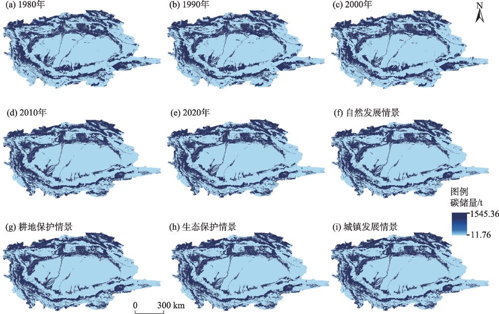
表9
1980—2020年土地利用变化引起碳储量变化"
| 转换类型 | 地上生物量碳储量 | 地下生物量碳储量 | 土壤碳储量 | 死亡有机物碳储量 | 总碳储量 |
|---|---|---|---|---|---|
| 耕地→林地 | 3.4991 | 0.7096 | 3.6700 | 0.1295 | 8.0082 |
| 耕地→草地 | -0.4314 | 0.1512 | -0.1791 | -0.1525 | -0.6118 |
| 耕地→水域 | -0.0559 | -0.0740 | -1.7823 | -0.0256 | -1.9378 |
| 耕地→建设用地 | -0.2093 | -0.3145 | -11.3690 | -0.1635 | -12.0563 |
| 耕地→未利用地 | -0.1390 | -0.1464 | -2.0337 | -0.0589 | -2.3781 |
| 小计 | 2.6634 | 0.3259 | -11.6941 | -0.2709 | -8.9758 |
| 林地→耕地 | -6.2481 | -1.2671 | -6.5533 | -0.2313 | -14.2999 |
| 林地→草地 | -19.7664 | -3.1410 | -19.7380 | -1.2278 | -43.8733 |
| 林地→水域 | -0.9380 | -0.2687 | -3.1442 | -0.0643 | -4.4152 |
| 林地→建设用地 | -0.2040 | -0.0534 | -0.7055 | -0.0144 | -0.9773 |
| 林地→未利用地 | -5.1821 | -1.4052 | -11.0918 | -0.3528 | -18.0319 |
| 小计 | -32.3386 | -6.1354 | -41.2329 | -1.8907 | -81.5975 |
| 草地→耕地 | 4.2023 | -1.4726 | 1.7444 | 1.4849 | 5.9590 |
| 草地→林地 | 23.0356 | 3.6605 | 23.0025 | 1.4309 | 51.1295 |
| 草地→水域 | 0.0486 | -1.2327 | -22.8375 | -0.0591 | -24.0806 |
| 草地→建设用地 | 0.0426 | -0.1114 | -2.7890 | -0.0072 | -2.8650 |
| 草地→未利用地 | -0.3195 | -31.8215 | -323.4689 | -1.7094 | -357.3192 |
| 小计 | 27.0097 | -30.9777 | -324.3484 | 1.1402 | -327.1763 |
| 水域→耕地 | 0.1132 | 0.1496 | 3.6058 | 0.0519 | 3.9204 |
| 水域→林地 | 0.8038 | 0.2303 | 2.6943 | 0.0551 | 3.7834 |
| 水域→草地 | -0.1306 | 3.3137 | 61.3911 | 0.1589 | 64.7330 |
| 水域→建设用地 | 0.0010 | 0.0011 | 0.0000 | 0.0000 | 0.0021 |
| 水域→未利用地 | -0.3083 | 0.6851 | 60.2365 | 0.0000 | 60.6133 |
| 小计 | 0.4790 | 4.3797 | 127.9277 | 0.2658 | 133.0522 |
| 建设用地→耕地 | 0.1485 | 0.2231 | 8.0658 | 0.1160 | 8.5535 |
| 建设用地→林地 | 0.3180 | 0.0832 | 1.0998 | 0.0225 | 1.5234 |
| 建设用地→草地 | -0.0081 | 0.0212 | 0.5302 | 0.0014 | 0.5447 |
| 建设用地→水域 | -0.0010 | -0.0010 | 0.0000 | 0.0000 | -0.0020 |
| 建设用地→未利用地 | -0.0038 | -0.0020 | 0.1246 | 0.0000 | 0.1187 |
| 小计 | 0.4535 | 0.3244 | 9.8204 | 0.1399 | 10.7382 |
| 未利用地→耕地 | 1.3583 | 1.4308 | 19.8711 | 0.5753 | 23.2356 |
| 未利用地→林地 | 4.2485 | 1.1520 | 9.0934 | 0.2893 | 14.7832 |
| 未利用地→草地 | 0.2498 | 24.8838 | 252.9471 | 1.3367 | 279.4175 |
| 未利用地→水域 | 0.0935 | -0.2078 | -18.2732 | 0.0000 | -18.3875 |
| 未利用地→建设用地 | 0.0784 | 0.0409 | -2.5377 | 0.0000 | -2.4184 |
| 小计 | 6.0286 | 27.2998 | 261.1008 | 2.2013 | 296.6304 |
| 总计 | 4.2956 | -4.7832 | 21.5736 | 1.5855 | 22.6713 |
| [1] | 张凯琪, 陈建军, 侯建坤, 等. 耦合InVEST与GeoSOS-FLUS模型的桂林市碳储量可持续发展研究[J]. 中国环境科学, 2022, 42(6): 2799-2809. |
| [Zhang Kaiqi, Chen Jianjun, Hou Jiankun, et al. Study on sustainable development of carbon storage in Guilin coupled with InVEST and GeoSOS-FLUS model[J]. China Environmental Science, 2022, 42(6): 2799-2809. ] | |
| [2] | 夏文浩, 王铭扬, 姜磊. 新疆农业碳排放强度时空变化趋势与收敛分析[J]. 干旱区地理, 2023, 46(7): 1145-1154. |
| [Xia Wenhao, Wang Mingyang, Jiang Lei. Spatiotemporal variation trends and convergence analysis of agricultural carbon emission intensity in Xinjiang[J]. Arid Land Geography, 2023, 46(7): 1145-1154. ] | |
| [3] | 孙方虎, 方凤满, 洪炜林, 等. 基于PLUS和InVEST模型的安徽省碳储量演化分析与预测[J]. 水土保持学报, 2023, 37(1): 151-158. |
| [Sun Fanghu, Fang Fengman, Hong Weilin, et al. Evolution analysis and prediction of carbon storage in Anhui Province based on PLUS and InVEST model[J]. Journal of Soil and Water Conservation, 2023, 37(1): 151-158. ] | |
| [4] | Cantarello E, Newton A C, Hill R A. Potential effects of future land-use change on regional carbon stocks in the UK Science Direct[J]. Environmental Science & Policy, 2011, 14(1): 40-52. |
| [5] | 孙欣欣, 薛建辉, 董丽娜. 基于PLUS模型和InVEST模型的南京市生态系统碳储量时空变化与预测[J]. 生态与农村环境学报, 2023, 39(1): 41-51. |
| [Sun Xinxin, Xue Jianhui, Dong Lina. Spatiotemporal change and prediction of carbon storage in Nanjing ecosystem based on PLUS model and InVEST model[J]. Journal of Ecology and Rural Environment, 2023, 39(1): 41-51. ] | |
| [6] | 张海青, 任婷. 基于PLUS模型的空间格局演变特征及驱动力研究——以辽宁省北镇市为例[J]. 沈阳建筑大学学报(社会科学版), 2022, 24(3): 230-238. |
| [Zhang Haiqing, Ren Ting. Study on spatial pattern evolution characteristics and driving forces based on PLUS model: Taking Beizhen City in Liaoning Province as an example[J]. Journal of Shenyang Jianzhu University (Social Science Edition), 2022, 24(3): 230-238. ] | |
| [7] | Lei T, Yu T, Wenxue F, et al. Dynamic simulation of land use/cover change and assessment of forest ecosystem carbon storage under climate change scenarios in Guangdong Province, China[J]. Remote Sensing, 2022, 14(10): 2330-2330. |
| [8] | 裴亮, 陈晨, 戴激光, 等. 基于马尔科夫模型的大凌河流域土地利用/覆被变化趋势研究[J]. 土壤通报, 2017, 48(3): 525-531. |
| [Pei Liang, Chen Chen, Dai Jiguang, et al. Research on forecast trend of land use and land cover change in Daling River Basin based on Markov model[J]. Chinese Journal of Soil Science, 2017, 48(3): 525-531. ] | |
| [9] | 李玥康, 姚斯洋, 闫峰, 等. 基于改进元胞自动机-马尔可夫模型的土地利用格局演变模拟与预测: 以新余市为例[J]. 水利水电技术(中英文), 2022, 53(4): 71-83. |
| [Li Yuekang, Yao Siyang, Yan Feng, et al. Improved cellular automata-Markov model-based simulation and prediction on evolution of land use pattern: A case of Xinyu City[J]. Water Conservancy and Hydropower Technology (Chinese and English), 2022, 53(4): 71-83. ] | |
| [10] | 高周冰, 王晓瑞, 隋雪艳, 等. 基于FLUS和InVEST模型的南京市生境质量多情景预测[J]. 农业资源与环境学报, 2022, 39(5): 1001-1013. |
| [Gao Zhoubing, Wang Xiaorui, Sui Xueyan, et al. Multi-scenario prediction of habitat quality in Nanjing based on FLUS and InVEST models[J]. Journal of Agricultural Resources and Environment, 2022, 39(5): 1001-1013. ] | |
| [11] |
曹祺文, 顾朝林, 管卫华. 基于土地利用的中国城镇化SD模型与模拟[J]. 自然资源学报, 2021, 36(4): 1062-1084.
doi: 10.31497/zrzyxb.20210419 |
|
[Cao Qiwen, Gu Chaolin, Guan Weihua. China’s urbanization SD modelling and simulation based on land use[J]. Journal of Natural Resources, 2021, 36(4): 1062-1084. ]
doi: 10.31497/zrzyxb.20210419 |
|
| [12] | 顾汉龙, 马天骏, 钱凤魁, 等. 基于CLUE-S模型县域土地利用情景模拟与碳排放效应分析[J]. 农业工程学报, 2022, 38(9): 288-296. |
| [Gu Hanlong, Ma Tianjun, Qian Fengkui, et al. County land use scenario simulation and carbon emission effect analysis using CLUE-S model[J]. Transactions of the Chinese Society of Agricultural Engineering, 2022, 38(9): 288-296. ] | |
| [13] | 蒋小芳, 段翰晨, 廖杰, 等. 基于PLUS-SD耦合模型的黑河流域中游甘临高地区土地利用研究[J]. 干旱区研究, 2022, 39(4): 1246-1258. |
| [Jiang Xiaofang, Duan Hanchen, Liao Jie, et al. Land use in the Gan-Lin-Gao region of middle reaches of Heihe River Basin based on a PLUS-SD coupling model[J]. Arid Zone Research, 2022, 39(4): 1246-1258. ] | |
| [14] | 牛统莉, 熊立华, 陈杰, 等. 基于PLUS模型的长江流域土地利用变化模拟与多情景预测[J]. 武汉大学学报(工学版), 2024, 57(2): 129-141. |
| [Niu Tongli, Xiong Lihua, Chen Jie, et al. Land use simulation and multi-scenario prediction of the Yangtze River Basin based on PLUS model[J]. Engineering Journal of Wuhan University, 2024, 57(2): 129-141. ] | |
| [15] |
谢向东, 林孝松, 王莹, 等. 基于PLUS模型的重庆市南川区土地利用多情景模拟[J]. 长江科学院院报, 2023, 40(6): 86-92.
doi: 10.11988/ckyyb.20221227 |
| [Xie Xiangdong, Lin Xiaosong, Wang Ying, et al. Multi-scenario simulation of land use in Nanchuan District, Chongqing City based on PLUS model[J]. Journal of Changjiang River Scientific Research Institute, 2023, 40(6): 86-92. ] | |
| [16] | 李俊, 杨德宏, 吴锋振, 等. 基于PLUS与InVEST模型的昆明市土地利用变化动态模拟与碳储量评估[J]. 水土保持通报, 2023, 43(1): 378-387. |
| [Li Jun, Yang Dehong, Wu Fengzhen, et al. Dynamic simulation of land use changes and assessment of carbon storage in Kunming City based on PLUS and InVEST models[J]. Bulletin of Soil and Water Conservation, 2023, 43(1): 378-387. ] | |
| [17] | 许源溪, 周波, 苏杰. 基于InVEST模型的四川省宜宾市2010—2020年碳承载力评价[J]. 水土保持通报, 2023, 43(1): 350-358. |
| [Xu Yuanxi, Zhou Bo, Su Jie. Carbon carrying capacity evaluation for Yibin City of Sichuan Provice based on the InVEST model during 2010—2020[J]. Journal of Soil and Water Conservation, 2023, 43(1): 350-358. ] | |
| [18] | 李月, 罗红芬. 基于InVEST模型的黔中喀斯特地区建设用地扩张碳储量变化研究[J]. 西北林学院学报, 2024, 39(1): 185-192, 199. |
| [Li Yue, Luo Hongfen. Carbon storage change of construction land expansion in central Guizhou’s karst region based on InVEST model[J]. Journal of Northwest Forestry University, 2024, 39(1): 185-192, 199. ] | |
| [19] | 杨潋威, 赵娟, 朱家田, 等. 基于PLUS和InVEST模型的西安市生态系统碳储量时空变化与预测[J]. 自然资源遥感, 2022, 34(4): 175-182. |
| [Yang Lianwei, Zhao Juan, Zhu Jiatian, et al. Spatial and temporal variation and prediction of ecosystem carbon storage in Xi’an based on PLUS and InVEST model[J]. Remote Sensing for Natural Resources, 2022, 34(4): 175-182. ] | |
| [20] | 张鹏, 李良涛, 苏玉姣, 等. 基于PLUS和InVEST模型的邯郸市碳储量空间分布特征研究[J]. 水土保持通报, 2023, 43(3): 338-348. |
| [Zhang Peng, Li Liangtao, Su Yujiao, et al. Spatial and temporal distribution characteristics of carbon storage in Handan City based on PLUS and InVEST models[J]. Bulletin of Soil and Water Conservation, 2023, 43(3): 338-348. ] | |
| [21] | 林彤, 杨木壮, 吴大放, 等. 基于InVEST-PLUS模型的碳储量空间关联性及预测: 以广东省为例[J]. 中国环境科学, 2022, 42(10): 4827-4839. |
| [Lin Tong, Yang Muzhuang, Wu Dafang, et al. Spatial correlation and prediction of land use carbon storage based on the InVEST-PLUS model: A case study in Guangdong Province[J]. China Environmental Science, 2022, 42(10): 4827-4839. ] | |
| [22] | 王璐晨, 韩海辉, 张俊, 等. 塔里木河流域土地利用及人类活动强度的时空演化特征研究[J]. 中国地质, 2024, 51(1): 203-220. |
| [Wang Luchen, Han Haihui, Zhang Jun, et al. Spatio-temporal evolution of land use and human activity intensity in the Tarim River Basin, Xinjiang[J]. Geology in China, 2024, 51(1): 203-220. ] | |
| [23] | 唐芳. 塔里木河中下游土地利用时空变化分析[D]. 乌鲁木齐: 新疆农业大学, 2023. |
| [Tang Fang. Spatiotemporal variation of land use in the middle and lower reaches of Tarim River[D]. Urumqi: Xinjiang Agricultural University, 2023. ] | |
| [24] | 楚智, 徐长春, 罗映雪, 等. 基于生态保护红线管理的塔里木河流域土地利用模拟及生态效益评价[J]. 生态学报, 2021, 41(18): 7380-7392. |
| [Chu Zhi, Xu Changchun, Luo Yingxue, et al. Land use simulation and ecological benefit evaluation in the Tarim River Basin based on ecological protection red line management[J]. Acta Ecologica Sinica, 2021, 41(18): 7380-7392. ] | |
| [25] | 吝静, 赵成义, 马晓飞, 等. 基于生态系统服务价值的塔里木河干流土地利用结构优化[J]. 干旱区研究, 2021, 38(4): 1140-1151. |
| [Lin Jing, Zhao Chengyi, Ma Xiaofei, et al. Optimization of land use structure based on ecosystem service value in the mainstream of Tarim River[J]. Arid Zone Research, 2021, 38(4): 1140-1151. ] | |
| [26] | 郭靖, 王光焰, 徐生武, 等. 水资源管理增强下的塔里木河上中游碳储量动态评估[J]. 干旱区研究, 2021, 38(3): 589-599. |
| [Guo Jing, Wang Guangyan, Xu Shengwu, et al. Dynamic assessment of Tarim River carbon storage under enhanced water resources management[J]. Arid Zone Research, 2021, 38(3): 589-599. ] | |
| [27] | 陈理庭, 蔡海生, 张婷, 等. 基于Markov-FLUS模型的饶河流域土地利用多情景模拟分析[J]. 生态学报, 2022, 42(10): 3947-3958. |
| [Chen Liting, Cai Haisheng, Zhang Ting, et al. Land use multi-scenario simulation analysis of Rao River Basin based on Markov-FLUS model[J]. Acta Ecologica Sinica, 2022, 42(10): 3947-3958. ] | |
| [28] |
朱文博, 张静静, 崔耀平, 等. 基于土地利用变化情景的生态系统碳储量评估: 以太行山淇河流域为例[J]. 地理学报, 2019, 74(3): 446-459.
doi: 10.11821/dlxb201903004 |
|
[Zhu Wenbo, Zhang Jingjing, Cui Yaoping, et al. Assessment of territorial ecosystem carbon storage based on land use change scenario: A case study in Qihe River Basin[J]. Acta Geographica Sinica, 2019, 74(3): 446-459. ]
doi: 10.11821/dlxb201903004 |
|
| [29] | 赵宁. 基于InVEST模型的渤海湾沿岸土地系统碳储量及生境质量评估[D]. 保定: 河北农业大学, 2020. |
| [Zhao Ning. Assessment of carbon reserves and habitat quality of land system along Bohai Bay based on InVEST model[D]. Baoding: Hebei Agricultural University, 2020. ] | |
| [30] | 夏婷婷. 塔里木河流域土地利用变化及驱动因素分析[D]. 乌鲁木齐: 新疆农业大学, 2023. |
| [Xia Tingting. Analysis of land use change and drivers in the Tarim River Basin[D]. Urumqi: Xinjiang Agricultural University, 2023. ] | |
| [31] | 王绮, 魏冶. 基于非经济生物量的中国耕地碳汇空间分布研究[J]. 资源开发与市场, 2017, 33(8): 928-932. |
| [Wang Qi, Wei Ye. Spatial pattern of arable land carbon sinks in China from the perspective of non-economic biomass[J]. Resource Development & Market, 2017, 33(8): 928-932. ] | |
| [32] | 周圣杰. 土地利用数据对动态植被模式模拟中国陆地生态系统碳源汇影响的研究[D]. 南京: 南京信息工程大学, 2022. |
| [Zhou Shengjie. Study on the influence of land use data on carbon sources of terrestrial ecosystems in China[D]. Nanjing: Nanjing University of Information Science and Technology, 2022. ] | |
| [33] | 颜安. 新疆土壤有机碳/无机碳空间分布特征及储量估算[D]. 北京: 中国农业大学, 2015. |
| [Yan An. Spatial distribution characteristics and reserve estimation of organic/inorganic carbon in Xinjiang soil[D]. Beijing: China Agricultural University, 2015. ] | |
| [34] | Liang X, Guan Q F, Clarke K C, et al. Understanding the drivers of sustainable land expansion using a patch-generating land use simulation (PLUS) model: A case study in Wuhan, China[J]. Computers, Environment and Urban Systems, 2021, 85: 101569, doi: 10.1016/j.compenvurbsys.2020.101569. |
| [35] | 杨玉海, 朱成刚, 汪洋, 等. 塔里木河下游生态输水对胡杨林生态系统碳循环的影响[J]. 干旱区地理, 2021, 44(3): 637-642. |
| [Yang Yuhai, Zhu Chenggang, Wang Yang, et al. Effects of ecological water conveyance on carbon cycle of Populus euphratica forest ecosystem in the lower reaches of Tarim River[J]. Arid Land Geography, 2021, 44(3): 637-642. ] | |
| [36] | 刘华, 董玲, 艾吉尔·阿不拉, 等. 塔里木河中游柽柳灌丛碳储量及其价值评估[J]. 江西农业大学学报, 2015, 37(3): 484-489. |
| [Liu Hua, Dong Ling, Abula Ajier, et al. Value of carbon sequestration of Tamarix in the midstream of the Tarim River[J]. Acta Agriculturae Universitatis Jiangxiensis, 2015, 37(3): 484-489. ] | |
| [37] | 叶朝霞, 何秉宇, 董秀梅. 塔里木河下游生态环境整治与生态效应分析[J]. 新疆地质, 2005(1): 55-58. |
| [Ye Zhaoxia, He Bingyu, Dong Xiumei. Analysis of ecological environment improvement and ecological effect in the lower reaches of Tarim River[J]. Xinjiang Geology, 2005(1): 55-58. ] | |
| [38] | 柯新利, 唐兰萍. 城市扩张与耕地保护耦合对陆地生态系统碳储量的影响: 以湖北省为例[J]. 生态学报, 2019, 39(2): 672-683. |
| [Ke Xinli, Tang Lanping. Impact of cascading processes of urban expansion and cropland reclamation on the ecosystem of a carbon storage service in Hubei Province, China[J]. Acta Ecologlca Sinica, 2019, 39(2): 672-683. ] | |
| [39] | Thompson T M. Modeling the climate and carbon systems to estimate the social cost of carbon[J]. Wiley Interdisciplinary Reviews Climate Change, 2018, 9(5): e532, doi: 10.1002/wcc.532. |
| [40] |
Wen H X, Yi G M, Ya J G, et al. Spatial-temporal pattern and spatial convergence of carbon emission intensity of rural energy consumption in China[J]. Environmental Science and Pollution Research International, 2024, 31(5): 7751-7774.
doi: 10.1007/s11356-023-31539-9 pmid: 38170355 |
| [1] | 姜萍, 袁野. 新疆植被总初级生产力对大气水分亏缺的响应[J]. 干旱区地理, 2024, 47(3): 403-412. |
| [2] | 安文举, 鱼亦凡, 郝姗姗, 王英弟, 李小兵, 麦旭东. 基于土地利用变化的陕北多沙粗沙区生境质量演变及响应分析[J]. 干旱区地理, 2024, 47(3): 474-484. |
| [3] | 韩楚翘, 郑江华, 王哲, 于雯婕. 基于PLUS-InVEST模型吐哈盆地陆地生态系统碳储量时空变化及多情景模拟[J]. 干旱区地理, 2024, 47(2): 260-269. |
| [4] | 张齐飞, 陈亚宁, 孙从建, 向燕芸, 郝海超. 塔里木河流域水储量变化及绿洲生态安全评估[J]. 干旱区地理, 2024, 47(1): 1-14. |
| [5] | 隋露, 闫志明, 李开放, 何佩恩, 马英杰, 张汝萃. 人类活动及气候变化影响下伊犁河谷生境质量预测研究[J]. 干旱区地理, 2024, 47(1): 104-116. |
| [6] | 彭娅, 王娟娟, 王珊珊, 田柳兰, 刘婕, 毋兆鹏. 生态安全视角下乌鲁木齐市土地利用冲突时空格局演变分析[J]. 干旱区地理, 2024, 47(1): 81-92. |
| [7] | 夏文浩, 王铭扬, 姜磊. 新疆农业碳排放强度时空变化趋势与收敛分析[J]. 干旱区地理, 2023, 46(7): 1145-1154. |
| [8] | 姚岚博, 冶建明, 王芸, 朱现伟. 干旱区人居环境系统耦合协调的时空演变及作用机制研究——以新疆为例[J]. 干旱区地理, 2023, 46(6): 1013-1023. |
| [9] | 杨锐, 李建勇, 王宁练, 陈小俊, 杜建峰, 刘剑波, 韩岳婷. 西天山温泉地区全新世沉积物元素地球化学记录及其古环境意义[J]. 干旱区地理, 2023, 46(6): 900-910. |
| [10] | 张梦圆, 荣丽华, 李伊彤, 党慧. 基于“三生”空间的农牧交错区城市土地利用转型及生态环境效应分析——以包头市为例[J]. 干旱区地理, 2023, 46(6): 958-967. |
| [11] | 穆佳薇, 乔保荣, 余国新. 新疆塔里木河流域县域农业低碳生产率时空格局及影响效应研究[J]. 干旱区地理, 2023, 46(6): 968-981. |
| [12] | 张烈琴, 陆亦农, 龙震, 李庆雷, 王涛. 新疆文化旅游空间分布格局[J]. 干旱区地理, 2023, 46(5): 823-833. |
| [13] | 董建红, 张志斌, 刘奔腾, 张新红. “三生”空间视角下西北地区生态环境质量分异机制的地理探测[J]. 干旱区地理, 2023, 46(4): 515-526. |
| [14] | 闫新杰, 孙慧, 辛龙. 新疆资源型企业的空间分布与区位选择[J]. 干旱区地理, 2023, 46(4): 678-687. |
| [15] | 张宁,汪子晨,杨肖,陈彤,邢飞. 新疆水资源与农业种植系统耦合协调及时空差异研究——以粮食和棉花种植系统为例[J]. 干旱区地理, 2023, 46(3): 349-359. |
|
||