干旱区地理 ›› 2026, Vol. 49 ›› Issue (7): 1336-1346.doi: 10.12118/j.issn.1000-6060.2025.683 cstr: 32274.14.ALG2025683
杨昊凡1( ), 黄维东1,2(), 牛最荣1
收稿日期:2025-10-23
修回日期:2025-12-28
出版日期:2026-07-25
发布日期:2026-07-07
通讯作者:
黄维东(1968-),男,本科,正高级工程师,主要从事水文水资源监测、水资源规划与管理、水旱灾害防治及流域水文过程研究.E-mail: gsdxhwd@163.com作者简介:杨昊凡(2000-),男,硕士研究生,主要从事干旱区水文过程与水旱灾害防治研究. E-mail: appreciates@foxmail.com
基金资助:
YANG Haofan1(), HUANG Weidong1,2(), NIU Zuirong1
Received:2025-10-23
Revised:2025-12-28
Published:2026-07-25
Online:2026-07-07
摘要:
陇中地区作为黄河上游生态安全关键区,水资源匮乏与干旱频发长期制约区域发展,揭示气候因子与干旱风险的耦合机制,对支撑精准抗旱、水资源配置及水利工程科学运行具有现实意义。基于1980—2023年降水量数据、潜在蒸散发(PET)数据,运用标准化降水蒸散指数(SPEI)、气候倾向率、空间插值等方法,系统分析干旱时空演变特征及其与降水量、潜在蒸散发的耦合关系。结果表明:(1) 陇中地区干旱演变历经1980—1990、1991—2010、2011—2023年3个阶段,对应干旱频率分别为29.55%、42.49%、23.72%。(2) 1991—2023年春夏季中度及以上等级干旱频率达19.23%及以上,对农业关键期影响重大;其中定西市春季PET呈极显著上升趋势(P<0.01),干旱态势加剧。(3) 厄尔尼诺事件会放大干旱风险,其发生年份的中度及以上等级干旱频率较非厄尔尼诺年份高出5.21个百分点。研究揭示了陇中地区气候因子与干旱风险的分异规律,可为区域分域抗旱、农业种植结构优化及水利工程调度提供科学支撑。
杨昊凡, 黄维东, 牛最荣. 陇中地区干旱特征及其与降水量和潜在蒸散发的关系[J]. 干旱区地理, 2026, 49(7): 1336-1346.
YANG Haofan, HUANG Weidong, NIU Zuirong. Drought characteristics and their relationship with precipitation and potential evapotranspiration in the Longzhong region[J]. Arid Land Geography, 2026, 49(7): 1336-1346.
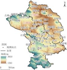
图1
研究区海拔及观测站点分布"
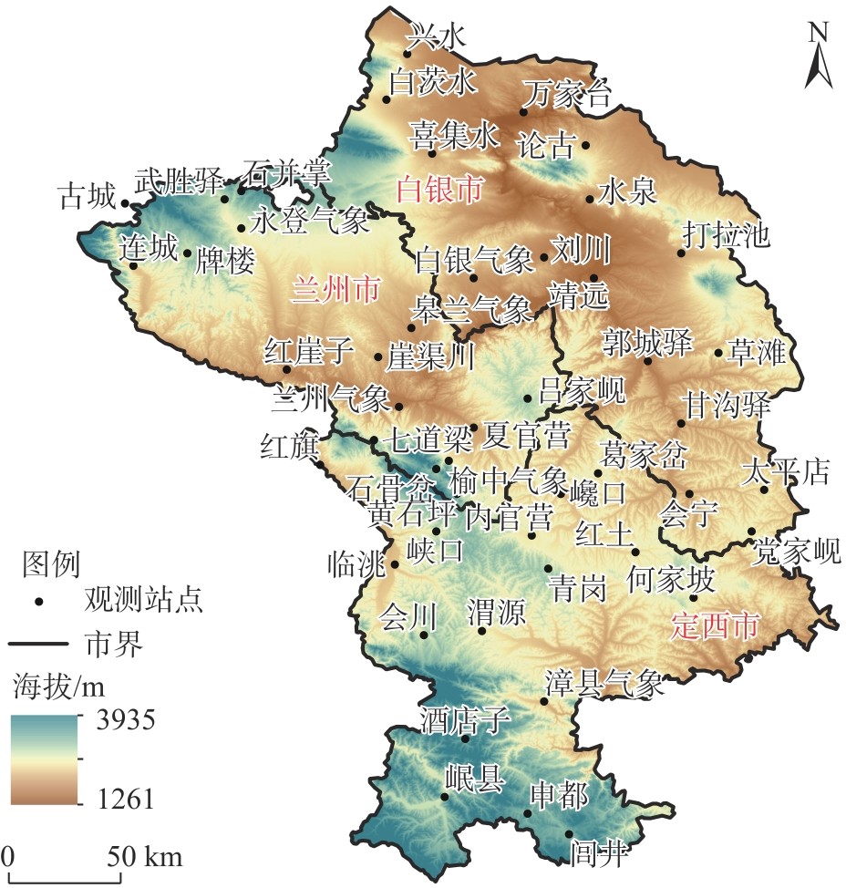

表1
年尺度各观测站点面积权重"
| 站点 | 面积权重 | 海拔/m | 站点 | 面积权重 | 海拔/m |
|---|---|---|---|---|---|
| 兰州气象站 | 0.0119 | 1534 | 会川站 | 0.0204 | 2253 |
| 红崖子站 | 0.0316 | 1668 | 临洮站 | 0.0137 | 1877 |
| 七道梁站 | 0.0138 | 2280 | 红旗站 | 0.0067 | 1780 |
| 皋兰气象站 | 0.0302 | 1672 | 漳县气象站 | 0.0355 | 1884 |
| 崖渠川站 | 0.0187 | 1827 | 岷县站 | 0.0315 | 2611 |
| 榆中气象站 | 0.0049 | 2160 | 酒店子站 | 0.0228 | 2702 |
| 夏官营站 | 0.0156 | 1703 | 申都站 | 0.0148 | 2585 |
| 吕家岘站 | 0.0303 | 2392 | 闾井站 | 0.0212 | 2618 |
| 黄石坪站 | 0.0098 | 2469 | 白银气象站 | 0.0317 | 1725 |
| 石骨岔站 | 0.0075 | 2539 | 水泉站 | 0.0216 | 1623 |
| 永登气象站 | 0.0293 | 2121 | 打拉池站 | 0.0387 | 1761 |
| 武胜驿站 | 0.0070 | 2488 | 兴水站 | 0.0160 | 1822 |
| 石并掌站 | 0.0091 | 2740 | 白茨水站 | 0.0183 | 1930 |
| 连城站 | 0.0161 | 1936 | 万家台站 | 0.0304 | 1431 |
| 牌楼站 | 0.0228 | 2255 | 喜集水站 | 0.0419 | 1769 |
| 古城站 | 0.0062 | 2800 | 论古站 | 0.0215 | 1854 |
| 红土站 | 0.0230 | 1977 | 靖远站 | 0.0220 | 1411 |
| 内官营站 | 0.0127 | 2029 | 刘川站 | 0.0214 | 1640 |
| 巉口站 | 0.0142 | 1881 | 郭城驿站 | 0.0251 | 1532 |
| 葛家岔站 | 0.0195 | 2176 | 甘沟驿站 | 0.0208 | 1625 |
| 青岗站 | 0.0218 | 2344 | 草滩站 | 0.0333 | 2132 |
| 何家坡站 | 0.0446 | 2133 | 会宁站 | 0.0175 | 1730 |
| 渭源站 | 0.0223 | 2092 | 太平店站 | 0.0136 | 2046 |
| 峡口站 | 0.0149 | 2194 | 党家岘站 | 0.0220 | 2174 |
表2
季尺度各观测站点面积权重"
| 站点 | 面积权重 | 海拔/m | 站点 | 面积权重 | 海拔/m |
|---|---|---|---|---|---|
| 兰州气象站 | 0.1245 | 1534 | 岷县站 | 0.0904 | 2611 |
| 武胜驿站 | 0.0803 | 2488 | 白银气象站 | 0.1445 | 1725 |
| 连城站 | 0.0439 | 1936 | 论古站 | 0.1478 | 1854 |
| 红土站 | 0.1069 | 1977 | 会宁站 | 0.1460 | 1730 |
| 渭源站 | 0.1156 | 2092 |
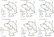
图2
1980—2023年陇中地区年均SPEI、降水量和PET及其倾向率的空间分布 注:SPEI为标准化降水蒸散指数;PET为潜在蒸散发。下同。"
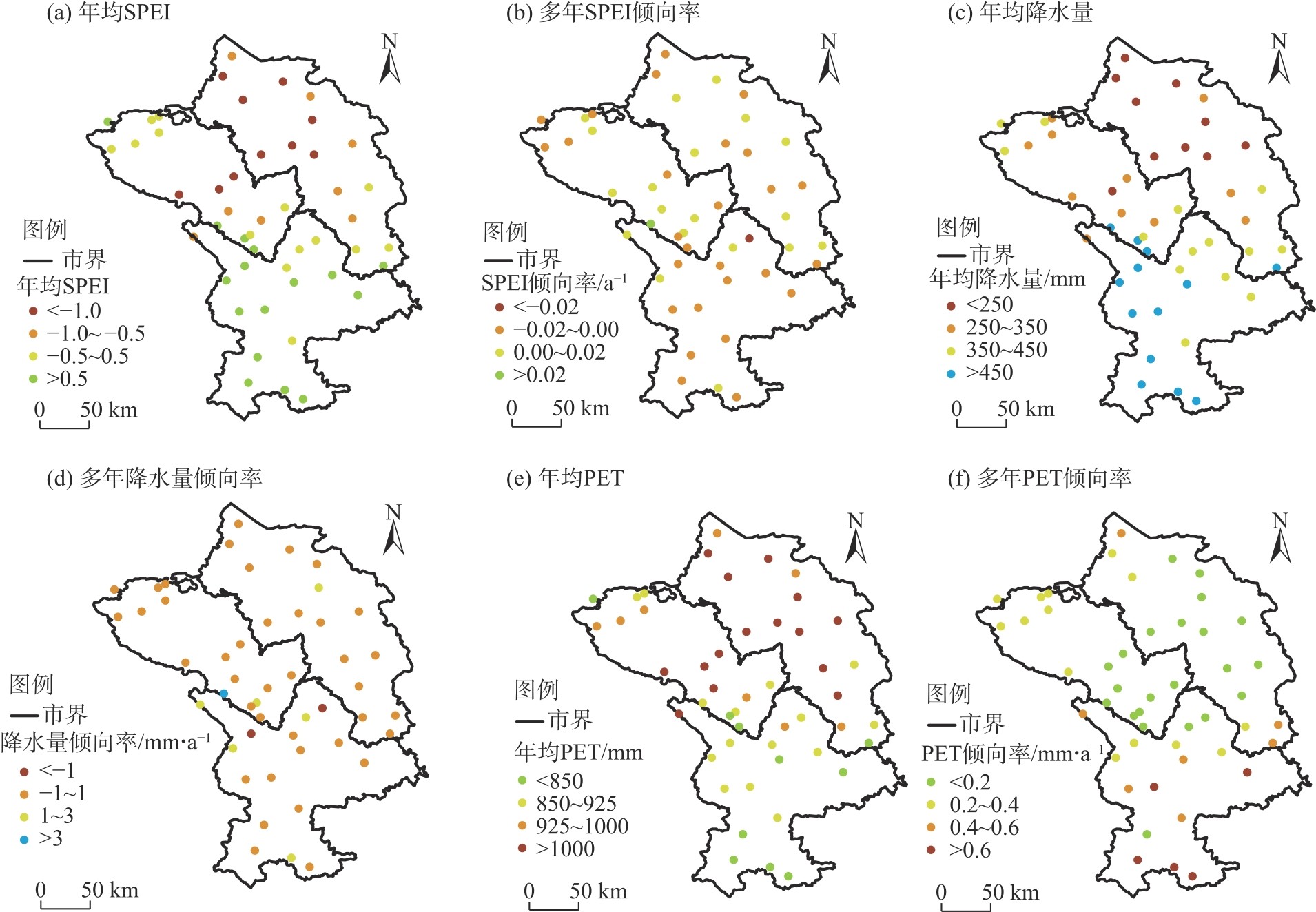
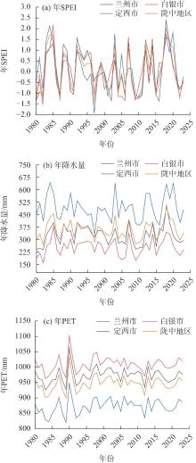
图3
1980—2023年陇中地区SPEI、降水量和PET年际变化趋势"
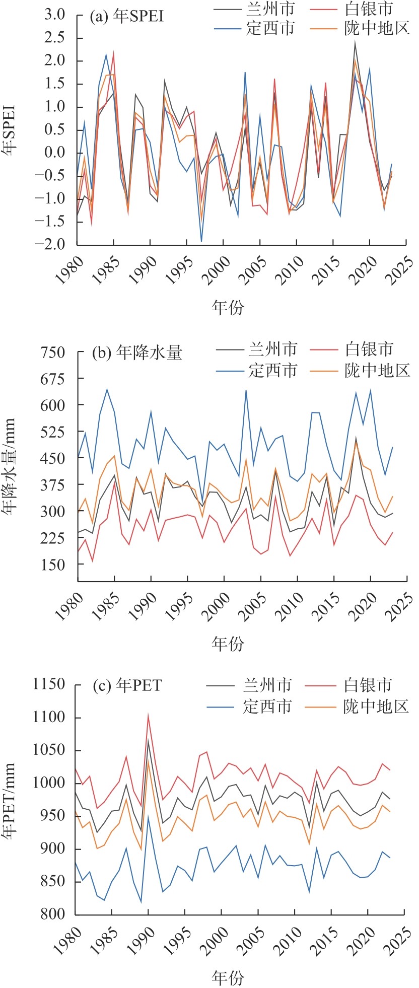
表3
1980—2023年陇中地区SPEI、降水量和PET倾向率"
| 区域 | 季节 | 降水量倾向率/mm·a-1 | PET倾向率/mm·a-1 | 差值/mm·a-1 | SPEI倾向率/a-1 | 区域 | 季节 | 降水量倾向率/mm·a-1 | PET倾向率/mm·a-1 | 差值/mm·a-1 | SPEI倾向率/a-1 |
|---|---|---|---|---|---|---|---|---|---|---|---|
| 兰州市 | 春季 | -0.02 | 0.22 | -0.24 | -0.01 | 定西市 | 春季 | -0.25 | 0.37** | -0.62 | -0.02 |
| 夏季 | -0.18 | 0.12 | -0.30 | -0.01 | 夏季 | -0.14 | 0.26 | -0.40 | -0.01 | ||
| 秋季 | 0.59 | -0.05 | 0.64 | 0.02 | 秋季 | 0.54 | -0.03 | 0.57 | 0.01 | ||
| 冬季 | 0.06 | -0.02 | 0.08 | 0.01 | 冬季 | -0.01 | 0.02 | -0.03 | 0.00 | ||
| 全年 | 0.31 | 0.19 | 0.12 | 0.00 | 全年 | 0.04 | 0.48 | -0.44 | -0.01 | ||
| 白银市 | 春季 | -0.11 | 0.21 | -0.32 | -0.01 | 陇中地区 | 春季 | -0.13 | 0.26 | -0.39 | -0.01 |
| 夏季 | -0.33 | 0.13 | -0.46 | -0.01 | 夏季 | -0.22 | 0.17 | -0.39 | -0.01 | ||
| 秋季 | 0.51 | -0.09 | 0.60 | 0.02 | 秋季 | 0.54 | -0.06 | 0.60 | 0.02 | ||
| 冬季 | 0.11 | -0.01 | 0.12 | 0.02 | 冬季 | 0.06 | 0.01 | 0.05 | 0.01 | ||
| 全年 | 0.24 | 0.17 | 0.07 | 0.00 | 全年 | 0.23 | 0.28 | -0.05 | 0.00 |
图4
1980—2023年陇中地区干旱次数与频率统计"
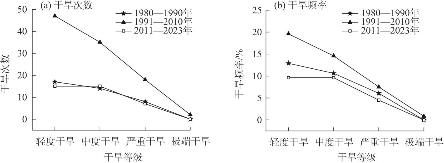
表4
1980—2023年陇中地区各阶段降水量和PET倾向率"
| 区域 | 年份 | 降水量倾向率 | PET倾向率 | 差值 | 区域 | 年份 | 降水量倾向率 | PET倾向率 | 差值 |
|---|---|---|---|---|---|---|---|---|---|
| 兰州市 | 1980—1990 | 11.50* | 3.62 | 7.88 | 定西市 | 1980—1990 | 2.07 | 3.15 | -1.08 |
| 1991—2010 | -4.26* | 0.74 | -5.00 | 1991—2010 | -0.39 | 1.14 | -1.53 | ||
| 2011—2023 | -0.12 | -0.03 | -0.09 | 2011—2023 | 0.71 | 0.75 | -0.04 | ||
| 白银市 | 1980—1990 | 8.10 | 3.52 | 4.58 | 陇中地区 | 1980—1990 | 7.13 | 3.39 | 3.74 |
| 1991—2010 | -2.99 | 0.39 | -3.38 | 1991—2010 | -2.32 | 0.74 | -3.06 | ||
| 2011—2023 | -1.64 | 2.03 | -3.67 | 2011—2023 | -0.30 | 1.06 | -1.36 |
表5
1980—2023年陇中地区各阶段中度及以上等级干旱频率"
| 年份 | 季节 | 兰州市 | 白银市 | 定西市 |
|---|---|---|---|---|
| 1980—1990 | 春夏季 | 13.64 | 9.09 | 9.09 |
| 秋冬季 | 22.73 | 22.73 | 22.73 | |
| 1991—2010 | 春夏季 | 27.50 | 22.50 | 22.50 |
| 秋冬季 | 20.00 | 20.00 | 25.00 | |
| 2011—2023 | 春夏季 | 19.23 | 19.23 | 26.92 |
| 秋冬季 | 7.69 | 7.69 | 3.85 |
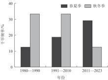
图5
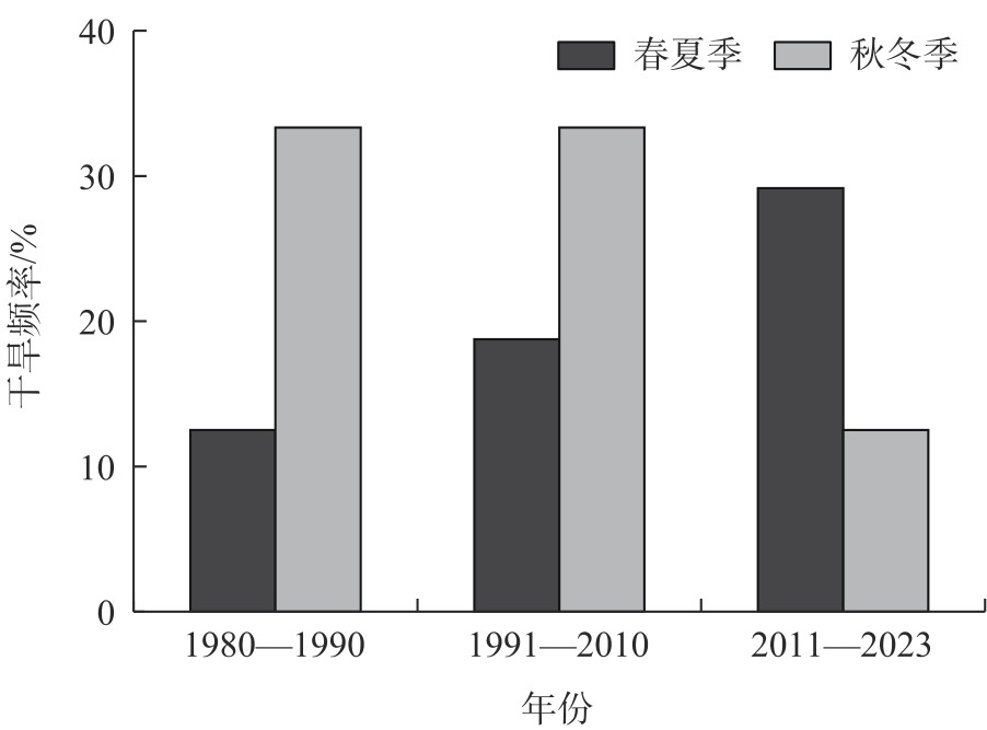
1980—2023年陇中地区厄尔尼诺年份中度及以上等级干旱频率"
| [1] | 顾杨旸, 赵文吉, 吴舒祺. 1980—2020年黄河流域气象干旱时空变化特征[J]. 中国农业气象, 2025, 46(8): 1192-1205. |
|
[Gu Yangyang, Zhao Wenji, Wu Shuqi. Temporal and spatial variations of drought in the Yellow River Basin from 1980 to 2020[J]. Chinese Journal of Agrometeorology, 2025, 46(8): 1192-1205.]
doi: 10.3969/j.issn.1000-6362.2025.08.011 |
|
| [2] |
郑孟林, 赵勇, 杨霞. 中国西北干旱区夏季降水异常的主模态年代际变化及其联系环流[J]. 干旱区地理, 2025, 48(9): 1511-1520.
doi: 10.12118/j.issn.1000-6060.2024.569 |
|
[Zheng Menglin, Zhao Yong, Yang Xia. Interdecadal changes and associated circulations in the dominant modes of summer rainfall anomaly in the arid region of northwest China[J]. Arid Land Geography, 2025, 48(9): 1511-1520.]
doi: 10.12118/j.issn.1000-6060.2024.569 |
|
| [3] | 田瀚文, 赵燕, 陈怡平, 等. 近50 a甘肃省气象干旱时空变化分析[J]. 地球环境学报, 2023, 14(5): 603-617. |
| [Tian Hanwen, Zhao Yan, Chen Yiping, et al. Analysis of the spatial and temporal variation of the meteorological drought in Gansu Province in recent 50 years[J]. Journal of Earth Environment, 2023, 14(5): 603-617.] | |
| [4] | 邵清军, 张俊红, 徐科展, 等. 甘肃白银农作物生长期降水量时空变化及干旱风险评估[J]. 成都信息工程大学学报, 2024, 39(2): 216-222. |
| [Shao Qingjun, Zhang Junhong, Xu Kezhan, et al. Spatial-temporal changes and drought risk assessment of precipitation during crop growth period in Baiyin City Gansu[J]. Journal of Chengdu University of Information Technology, 2024, 39(2): 216-222.] | |
| [5] | 王莉霞, 丁司铎, 张红丽, 等. 基于SPI指数的甘肃省不同自然气候区干旱特征及变化趋势分析[J]. 天水师范学院学报, 2021, 41(5): 29-38. |
| [Wang Lixia, Ding Siduo, Zhang Hongli, et al. Analysis of drought characteristics and trends based on SPI index in different natural climate regions of Gansu Province[J]. Journal of Tianshui Normal University, 2021, 41(5): 29-38.] | |
| [6] | 周俊菊, 冯炜, 向鹃, 等. 基于SPEI指数的近58 a甘肃省干旱特征分析[J]. 气象科学, 2022, 42(1): 99-107. |
| [Zhou Junju, Feng Wei, Xiang Juan, et al. Analysis of drought characteristics in Gansu Province in recent 58 years based on SPEI index[J]. Journal of the Meteorological Sciences, 2022, 42(1): 99-107.] | |
| [7] |
王志春, 王彦平, 徐震宇, 等. 内蒙古不同干湿区潜在蒸散发变化特征及主导因子分析[J]. 干旱区地理, 2025, 48(4): 612-622.
doi: 10.12118/j.issn.1000-6060.2024.480 |
|
[Wang Zhichun, Wang Yanping, Xu Zhenyu, et al. Changes characteristics and dominant factors of potential evapotranspiration in different dry and wet zones of Inner Mongolia[J]. Arid Land Geography, 2025, 48(4): 612-622.]
doi: 10.12118/j.issn.1000-6060.2024.480 |
|
| [8] | 张克新, 苏志华, 刘金林, 等. 甘肃省降水集中度的变化特征及其与环流指数遥相关分析[J]. 水土保持研究, 2021, 28(5): 261-267. |
| [Zhang Kexin, Su Zhihua, Liu Jinlin, et al. Characteristics of variation of precipitation concentration index and its teleconnection relationships with large-scale atmospheric circulations in Gansu Province[J]. Research of Soil and Water Conservation, 2021, 28(5): 261-267.] | |
| [9] |
戴文渊, 张清华, 史权, 等. 2003—2022年黄河流域甘肃段水生态安全协同驱动机制研究[J]. 干旱区地理, 2025, 48(11): 1939-1950.
doi: 10.12118/j.issn.1000-6060.2024.753 |
|
[Dai Wenyuan, Zhang Qinghua, Shi Quan, et al. Synergistic driving mechanisms of water ecological security in the Gansu section of the Yellow River Basin from 2003 to 2022[J]. Arid Land Geography, 2025, 48(11): 1939-1950.]
doi: 10.12118/j.issn.1000-6060.2024.753 |
|
| [10] |
张昕晗, 赵文婷, 焦菊英, 等. 1960—2023年黄土高原极端降水事件时空演变特征[J]. 干旱区地理, 2025, 48(7): 1153-1166.
doi: 10.12118/j.issn.1000-6060.2024.461 |
|
[Zhang Xinhan, Zhao Wenting, Jiao Juying, et al. Spatiotemporal evolution characteristics of extreme precipitation events on the Loess Plateau from 1960 to 2023[J]. Arid Land Geography, 2025, 48(7): 1153-1166.]
doi: 10.12118/j.issn.1000-6060.2024.461 |
|
| [11] | 李帅, 曾凌, 张存杰, 等. 长江上游近120年来气象干旱和水文干旱时空变化关系及其传递特征[J]. 气候变化研究进展, 2023, 19(3): 263-277. |
| [Li Shuai, Zeng Ling, Zhang Cunjie, et al. Spatio-temporal variations and propagation from meteorological to hydrological drought in the upper Yangtze River Basin over last 120 years[J]. Climate Change Research, 2023, 19(3): 263-277.] | |
| [12] | 李敏, 王兴繁, 孙栋元, 等. 基于SPEI的甘肃省气象干旱时空演变特征分析[J]. 水土保持研究, 2025, 32(5): 191-200, 212. |
| [Li Min, Wang Xingfan, Sun Dongyuan, et al. Analysis of spatiotemporal evolution characteristics of meteorological droughts in Gansu Province based on SPEI[J]. Research of Soil and Water Conservation, 2025, 32(5): 191-200, 212.] | |
| [13] | 胡铁军, 张亮. 1961—2020年中国西北地区干旱时空演变特征及其对植被的影响[J]. 节水灌溉, 2025(4): 96-102, 117. |
| [Hu Tiejun, Zhang Liang. Characteristics of spatial and temporal evolution of drought and its impact on vegetation in northwest China, 1961—2020[J]. Water Saving Irrigation, 2025(4): 96-102, 117.] | |
| [14] | 郑健, 鲍婷婷, 王春霞, 等. 考虑气候分区的甘肃省干旱时空分布特征分析[J]. 农业机械学报, 2023, 54(2): 311-320. |
| [Zheng Jian, Bao Tingting, Wang Chunxia, et al. Spatial and temporal distribution characteristics of drought in Gansu Province considering climate zoning[J]. Transactions of the Chinese Society for Agricultural Machinery, 2023, 54(2): 311-320.] | |
| [15] |
菅煜婷, 张勃, 黄浩. 近58年甘肃气候变化区域差异分析及环流影响[J]. 高原气象, 2022, 41(5): 1291-1301.
doi: 10.7522/j.issn.1000-0534.2021.00066 |
|
[Jian Yuting, Zhang Bo, Huang Hao. Regional difference analysis of climate change in Gansu Province in recent 58 years and its impact on circulation[J]. Plateau Meteorology, 2022, 41(5): 1291-1301.]
doi: 10.7522/j.issn.1000-0534.2021.00066 |
|
| [16] | 李欣璋, 别强, 石莹, 等. 中国西北地区不同类型草地NDVI对SPEI的时空响应特征[J/OL]. 甘肃农业大学学报. [2025-12-22]. https://link.cnki.net/urlid/62.1055.s.20251202.2007.008. |
| [Li Xinzhang, Bie Qiang, Shi Ying, et al. Spatiotemporal response characteristics of NDVI to SPEI in different grassland types in northwest China[J/OL]. Journal of Gansu Agricultural University. [2025-12-22]. https://link.cnki.net/urlid/62.1055.s.20251202.2007.008.] | |
| [17] | 卓玛草, 袁建钰, 韩博, 等. 气候变化对甘肃省雨养农业区玉米种植区划的影响[J]. 干旱地区农业研究, 2021, 39(2): 211-219. |
| [Zhuoma Cao, Yuan Jianyu, Han Bo, et al. Impact of climate change on maize-planting zoning in rainfed agricultural area of Gansu Province[J]. Agricultural Research in the Arid Areas, 2021, 39(2): 211-219.] | |
| [18] | 彭守璋. 中国1 km逐月潜在蒸散发数据集(1901—2024)[DS/OL]. 国家青藏高原科学数据中心. [2025-12-22]. https://dx.doi.org/10.11866/db.loess.2021.001. |
| [Peng Shouzhang. 1-km monthly potential evapotranspiration dataset for China (1901—2024)[J]. National Tibetan Plateau/Third Pole Environment Data Center. [2025-12-22]. https://dx.doi.org/10.11866/db.loess.2021.001.] | |
| [19] |
Peng S Z, Ding Y X, Wen Z M, et al. Spatiotemporal change and trend analysis of potential evapotranspiration over the Loess Plateau of China during 2011—2100[J]. Agricultural and Forest Meteorology, 2017, 233: 183-194.
doi: 10.1016/j.agrformet.2016.11.129 |
| [20] | Ding Y X, Peng S Z. Spatiotemporal trends and attribution of drought across China from 1901—2100[J]. Sustainability, 2020, 12(2): 477, doi: 10.3390/su12020477. |
| [21] |
Ding Y X, Peng S Z. Spatiotemporal change and attribution of potential evapotranspiration over China from 1901 to 2100[J]. Theoretical and Applied Climatology, 2021, 145(1): 79-94.
doi: 10.1007/s00704-021-03625-w |
| [22] |
Peng S Z, Ding Y X, Liu W Z, et al. 1 km monthly temperature and precipitation dataset for China from 1901 to 2017[J]. Earth System Science Data, 2019, 11(4): 1931-1946.
doi: 10.5194/essd-11-1931-2019 |
| [23] | NOAA Climate Prediction Center. Historical El Niño/La Niña episodes (1950-present)[EB/OL]. [2025-10-02]. https://www.cpc.ncep.noaa.gov/products/analysis_monitoring/ensostuff/ONI_v5.php. |
| [24] | 叶伟林, 黄钰涵, 周自强, 等. 祁连山地区近60年气温时空变化特征[J]. 科学技术与工程, 2022, 22(4): 1344-1353. |
| [Ye Weilin, Huang Yuhan, Zhou Ziqiang, et al. Temporaland spatial variations of air temperature in the Qilian Mountains during the past 60 years[J]. Science Technology and Engineering, 2022, 22(4): 1344-1353.] | |
| [25] |
Vicente-Serrano S M, Beguería S, López-Moreno J I. A multiscalar drought index sensitive to global warming: The standardized precipitation evapotranspiration index[J]. Journal of Climate, 2010, 23(7): 1696-1718.
doi: 10.1175/2009JCLI2909.1 |
| [26] |
Yang Q, Ma Z G, Zheng Z Y, et al. Sensitivity of potential evapotranspiration estimation to the Thornthwaite and Penman-Monteith methods in the study of global drylands[J]. Advances in Atmospheric Sciences, 2017, 34(12): 1381-1394.
doi: 10.1007/s00376-017-6313-1 |
| [27] |
Allen R G, Pruitt W O. Rational use of the FAO blaney-criddle formula[J]. Journal of Irrigation and Drainage Engineering, 1986, 112(2): 139-155.
doi: 10.1061/(ASCE)0733-9437(1986)112:2(139) |
| [28] | GB/T20481-2017. 中华人民共和国国家标准: 气象干旱等级[S]. 北京: 中国标准出版社, 2017. |
| [GB/T20481-2017. National standard of the People’s Republic of China: Meteorological drought levels[S]. Beijing: China Standards Press, 2017.] | |
| [29] | 魏凤英. 现代气候统计诊断与预测技术[M]. 第2版. 北京: 气象出版社, 2007. |
| [Wei Fengying. Modern climate statistical diagnosis and prediction techniques[M]. 2nd ed. Beijing: Meteorological Press, 2007.] | |
| [30] | 张强, 杨泽粟, 郝小翠, 等. 北方蒸散对气候变暖响应随降水类型转换特征[J]. 科学通报, 2018, 63(11): 1035-1049. |
| [Zhang Qiang, Yang Zesu, Hao Xiaocui, et al. Transition features of surface evapotranspiration responding to climate warming with spatial precipitation-based climate type in northern China[J]. Chinese Science Bulletin, 2018, 63(11): 1035-1049.] | |
| [31] | 杨司琪, 张强, 奚小霞, 等. 中国夏季风影响过渡区与其他地区蒸发皿蒸发量趋势相反的原因[J]. 大气科学, 2019, 43(6): 1441-1450. |
| [Yang Siqi, Zhang Qiang, Xi Xiaoxia, et al. The reason of trends in pan evaporation in the summer monsoon transition region contrary to those of other regions in China[J]. Chinese Journal of Atmospheric Sciences, 2019, 43(6): 1441-1450.] | |
| [32] |
杨司琪, 张强, 奚小霞, 等. 夏季风影响过渡区与非夏季风影响过渡区蒸发皿蒸发趋势的对比分析[J]. 高原气象, 2018, 37(4): 1017-1024.
doi: 10.7522/j.issn.1000-0534.2018.00006 |
|
[Yang Siqi, Zhang Qiang, Xi Xiaoxia, et al. Comparative analysis of pan evaporation trends between the summer monsoon transition region and other regions of China[J]. Plateau Meteorology, 2018, 37(4): 1017-1024.]
doi: 10.7522/j.issn.1000-0534.2018.00006 |
|
| [33] | 阳伏林, 张强, 王文玉, 等. 黄土高原春小麦农田蒸散及其影响因素[J]. 生态学报, 2014, 34(9): 2323-2328. |
| [Yang Fulin, Zhang Qiang, Wang Wenyu, et al. Evapotranspiration and factors influencing evapotranspiration in the spring wheat farmland of China’s Loess Plateau[J]. Acta Ecologica Sinica, 2014, 34(9): 2323-2328.] | |
| [34] | 张强, 张之贤, 问晓梅, 等. 陆面蒸散量观测方法比较分析及其影响因素研究[J]. 地球科学进展, 2011, 26(5): 538-547. |
| [Zhang Qiang, Zhang Zhixian, Wen Xiaomei, et al. Comparisons of observational methods of land surface evapotranspiration and their influence factors[J]. Advances in Earth Science, 2011, 26(5): 538-547.] |
| [1] | 温明君, 武志涛, 杜自强, 梁寒雪, 陈鑫, 雷添杰. 蒙古高原生态干旱监测及时空变化[J]. 干旱区地理, 2026, 49(7): 1311-1322. |
| [2] | 艳燕, 刘雨露, 张伟阁, 孙茜, 朱士华. 多源土地覆盖产品在中国西北干旱区的精度评价与一致性分析[J]. 干旱区地理, 2026, 49(7): 1405-1417. |
| [3] | 高莹, 周可丽, 元媛, 史薪茹, 吴佳霖. 黄河流域旅游经济与居民福祉耦合协调时空演变及驱动机制研究[J]. 干旱区地理, 2026, 49(7): 1493-1508. |
| [4] | 刘洋洋, 毛克彪, 郭中华, 袁紫晋. 中国气象干旱时空特征与混合模型预测[J]. 干旱区地理, 2026, 49(5): 881-893. |
| [5] | 周悦, 鲁瑞洁, 黄梦真. 伊犁河流域多时间尺度气象干旱时空特征[J]. 干旱区地理, 2026, 49(5): 894-906. |
| [6] | 周灵敏, 伊木然·库鲁万, 玉素甫江·如素力, 吴海智, 娜扎开提·尼加提. 中国西北干旱区大型湖泊湖冰物候时空差异及影响因素[J]. 干旱区地理, 2026, 49(3): 484-495. |
| [7] | 张亚茹, 何莹莹, 于明含, 吴浩, 郑翔, 张萍. 基于CiteSpace的降水对植物非结构性碳水化合物影响的可视化分析[J]. 干旱区地理, 2026, 49(3): 521-533. |
| [8] | 徐文昭, 赵东风, 卢磊, 杜海波, 赵公大, 买里旦·莫塔里甫. 某石化水库植物群丛生物量与不同土层土壤理化性质研究[J]. 干旱区地理, 2026, 49(3): 559-568. |
| [9] | 张璐, 周秉荣, 颜玉倩, 曹晓云, 马有绚. 西风-夏季风协同作用对青藏高原夏季降水的影响研究[J]. 干旱区地理, 2026, 49(2): 332-342. |
| [10] | 王圣节, 张庆红, 桑铭键. 基于改进深度学习模型的干旱区城市PM2.5浓度预测与应用研究[J]. 干旱区地理, 2026, 49(2): 343-355. |
| [11] | 程西安, 牛全福, 王刚, 邵东虎, 朱登峰, 王振宇. 黄土高原植被抗旱性监测及影响因素分析[J]. 干旱区地理, 2026, 49(1): 1-12. |
| [12] | 阿力木·艾尔肯, 李如琦, 努尔扎提·阿卜杜柯尤木, 玛依热·艾海提, 希热娜依·铁里瓦尔地. 1961—2022年新疆南部降雨和极端降雨特征[J]. 干旱区地理, 2026, 49(1): 13-22. |
| [13] | 郑孟林, 赵勇, 杨霞. 中国西北干旱区夏季降水异常的主模态年代际变化及其联系环流[J]. 干旱区地理, 2025, 48(9): 1511-1520. |
| [14] | 刘京会, 袁旭山, 李艳敏, 李鑫旭. 基于CMIP6的伊犁河流域极端降水时空特征分析研究[J]. 干旱区地理, 2025, 48(8): 1329-1341. |
| [15] | 张春燕, 李岩瑛, 吴雯, 陈静, 马幸蔚, 聂鑫. 河西走廊夏秋季2次强沙尘暴天气成因及传输特征分析[J]. 干旱区地理, 2025, 48(8): 1363-1373. |
|
||

