干旱区地理 ›› 2022, Vol. 45 ›› Issue (2): 467-477.doi: 10.12118/j.issn.1000–6060.2021.199 cstr: 32274.14.ALG2021199
任立清( )
)
收稿日期:2021-05-02
修回日期:2021-08-10
出版日期:2022-03-25
发布日期:2022-04-02
作者简介:任立清(1967-),女,硕士,高级工程师,主要从事气象卫星地面系统、气象雷达等设备及卫星资料在气象应用方面的研究. E-mail: 基金资助:
REN Liqing()
Received:2021-05-02
Revised:2021-08-10
Published:2022-03-25
Online:2022-04-02
摘要:
植被是反映陆地生态系统变化的敏感因子之一,对维持和调节生态系统稳定具有重要作用。以生态脆弱区艾比湖流域为研究区,采用地理探测器模型,研究艾比湖流域自然、人文因子及其交互作用对植被时空覆盖变化的影响,分析各影响因子促进植被生长的适宜范围(类别)。结果表明:(1) 2000—2020年艾比湖流域归一化植被指数(NDVI)呈现增加趋势,增速为0.035·(10a)-1,生态环境得到有效改善,改善区域主要分布在中西部,显著提高地区主要位于艾比湖中部,严重退化地区零散分布在艾比湖中部中心位置。(2) 土地利用类型、植被类型和土壤类型因素对植被NDVI空间分布的影响力大于其他因子,是主要影响因子。自然、人文因子之间对植被NDVI的交互作用以非线性增强和双因子增强效应为主,不存在独立关系。(3) 耕地、栽培植被、人为土、中起伏山地、高程2177~2558 m、年降水量228~245 mm、年均气温4.74~5.25 ℃、坡向157.5°~202.5°以及坡度25°~35°,适合植被生长。研究结果将为艾比湖流域的生态保护提供科学依据。
任立清. 艾比湖流域植被时空变化及驱动力分析[J]. 干旱区地理, 2022, 45(2): 467-477.
REN Liqing. Spatiotemporal change and driving force of vegetation in Ebinur Lake Basin[J]. Arid Land Geography, 2022, 45(2): 467-477.

图1
研究区示意图"
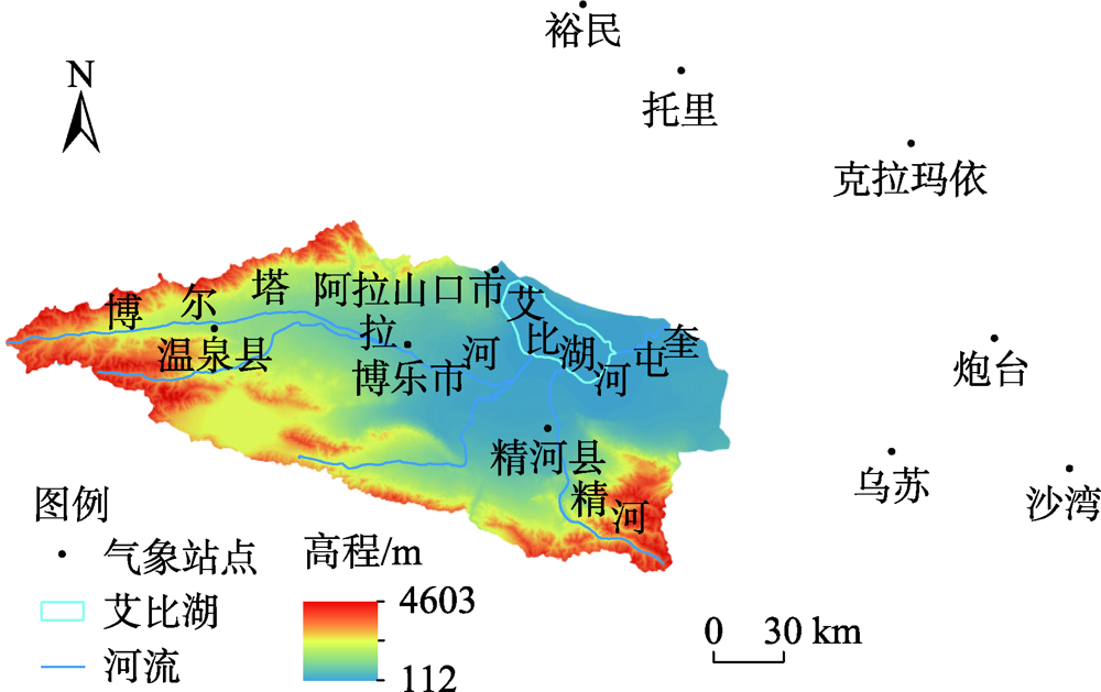
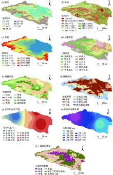
图2
探测因子分类图"

表1
探测因子"
| 因子类型 | 探测因子 | 指标 |
|---|---|---|
| 地形 | X1 | 坡度/(°) |
| X2 | 坡向/(°) | |
| X3 | 高程/m | |
| 土壤 | X4 | 土壤类型 |
| 植被 | X5 | 植被类型 |
| 地貌 | X6 | 地貌类型 |
| 气候 | X7 | 年均气温/℃ |
| X8 | 年降水量/mm | |
| 人类活动 | X9 | 土地利用类型 |
表2
探测因子交互作用类型"
| 依据 | 交互作用 |
|---|---|
| q(X1∩X2)<Min[q(X1),q(X2)] | 非线性减弱 |
| Min[q(X1),q(X2)]<q(X1∩X2)<Max[q(X1),q(X2)] | 单因子非线性减弱 |
| q(X1∩X2)>Max[q(X1),q(X2)] | 相互增强 |
| q(X1∩X2)=q(X1)+q(X2) | 独立 |
| q(X1∩X2)>q(X1)+q(X2) | 非线性增强 |

图3
2000—2020年艾比湖植被NDVI年际变化 注:NDVI为艾比湖流域年平均归一化植被指数。下同。"
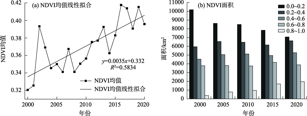
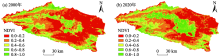
图4
2000—2020年艾比湖植被NDVI空间变化"

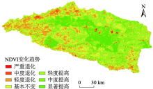
图5
2000—2020年艾比湖植被NDVI空间变化趋势"

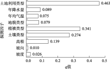
图6
因子探测结果 注:q为探测因子对NDVI的影响力。"
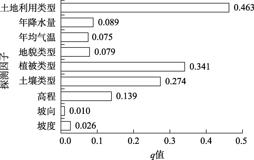
表3
各因子交互作用"
| 因子 | 坡度 | 坡向 | 高程 | 土壤类型 | 植被类型 | 地貌类型 | 年均气温 | 年降水量 | 土地利用类型 |
|---|---|---|---|---|---|---|---|---|---|
| 坡度 | 0.03 | ||||||||
| 坡向 | 0.09+ | 0.01 | |||||||
| 高程 | 0.21+ | 0.25+ | 0.14 | ||||||
| 土壤类型 | 0.34+ | 0.40+ | 0.42+ | 0.27 | |||||
| 植被类型 | 0.38+ | 0.39+ | 0.46++ | 0.47++ | 0.34 | ||||
| 地貌类型 | 0.11+ | 0.13+ | 0.22+ | 0.33++ | 0.41++ | 0.08 | |||
| 年均气温 | 0.21+ | 0.20+ | 0.35+ | 0.48+ | 0.47+ | 0.24+ | 0.08 | ||
| 年降水量 | 0.25+ | 0.23+ | 0.38+ | 0.51+ | 0.47+ | 0.27+ | 0.11++ | 0.09 | |
| 土地利用类型 | 0.52+ | 0.50+ | 0.64+ | 0.61++ | 0.58++ | 0.55+ | 0.56+ | 0.55+ | 0.46 |
表4
生态探测结果"
| 因子 | 坡度 | 坡向 | 高程 | 土壤类型 | 植被类型 | 地貌类型 | 年均气温 | 年降水量 | 土地利用类型 |
|---|---|---|---|---|---|---|---|---|---|
| 坡度 | |||||||||
| 坡向 | N | ||||||||
| 高程 | Y | Y | |||||||
| 土壤类型 | Y | Y | Y | ||||||
| 植被类型 | Y | Y | Y | N | |||||
| 地貌类型 | N | N | N | Y | Y | ||||
| 年均气温 | N | N | N | Y | Y | N | |||
| 年降水量 | N | N | N | Y | Y | N | N | ||
| 土地利用类型 | Y | Y | Y | Y | Y | Y | Y | Y |
表5
各因子适应范围(类别)"
| 因子 | 植被NDVI适应范围(类别) | 植被NDVI均值 |
|---|---|---|
| 坡度 | 25°~35° | 0.500 |
| 坡向 | 157.5°~202.5° | 0.439 |
| 高程 | 2177~2558 m | 0.572 |
| 土壤类型 | 人为土 | 0.759 |
| 植被类型 | 栽培植被 | 0.714 |
| 地貌类型 | 中起伏山地 | 0.459 |
| 年均气温 | 4.74~5.25 ℃ | 0.500 |
| 年降水量 | 228~245 mm | 0.661 |
| 土地利用类型 | 耕地 | 0.725 |
表6
不同土地利用类型中植被NDVI均值及显著性差异"
| 土地利用类型 | 耕地 | 林地 | 草地 | 水域 | 城乡工矿居民用地 | 未利用土地 |
|---|---|---|---|---|---|---|
| 耕地 | ||||||
| 林地 | N | |||||
| 草地 | Y | Y | ||||
| 水域 | Y | Y | Y | |||
| 城乡工矿居民用地 | N | N | N | N | ||
| 未利用土地 | Y | Y | Y | N | N | |
| 植被NDVI均值 | 0.73 | 0.66 | 0.42 | 0.25 | 0.54 | 0.21 |
表7
不同植被类型中植被NDVI均值及显著性差异"
| 植被类型 | 其他 | 针叶林 | 灌丛 | 荒漠 | 草原 | 草甸 | 高山植被 | 栽培植被 |
|---|---|---|---|---|---|---|---|---|
| 其他 | ||||||||
| 针叶林 | Y | |||||||
| 灌丛 | Y | N | ||||||
| 荒漠 | N | Y | Y | |||||
| 草原 | Y | Y | Y | Y | ||||
| 草甸 | Y | Y | Y | Y | Y | |||
| 高山植被 | N | Y | Y | Y | Y | Y | ||
| 栽培植被 | Y | Y | N | Y | Y | Y | Y | |
| 植被NDVI均值 | 0.27 | 0.59 | 0.69 | 0.29 | 0.39 | 0.50 | 0.19 | 0.71 |
表8
不同土壤类型中植被NDVI均值及显著性差异"
| 土壤类型 | 半淋溶土 | 钙层土 | 干旱土 | 漠土 | 初育土 | 半水成土 | 水成土 | 盐碱土 | 人为土 | 高山土 | 湖泊水库 | 冰川雪被 |
|---|---|---|---|---|---|---|---|---|---|---|---|---|
| 半淋溶土 | ||||||||||||
| 钙层土 | Y | |||||||||||
| 干旱土 | Y | Y | ||||||||||
| 漠土 | Y | N | Y | |||||||||
| 初育土 | Y | Y | Y | Y | ||||||||
| 半水成土 | N | Y | Y | Y | Y | |||||||
| 水成土 | N | N | N | N | Y | N | ||||||
| 盐碱土 | Y | N | N | N | Y | Y | N | |||||
| 人为土 | Y | Y | Y | Y | Y | N | Y | Y | ||||
| 高山土 | Y | Y | Y | N | Y | Y | N | N | Y | |||
| 湖泊水库 | Y | Y | N | Y | N | Y | N | N | Y | Y | ||
| 冰川雪被 | Y | Y | Y | Y | N | Y | Y | Y | Y | Y | N | |
| 植被NDVI均值 | 0.63 | 0.41 | 0.29 | 0.43 | 0.15 | 0.68 | 0.47 | 0.38 | 0.76 | 0.46 | 0.26 | 0.16 |
| [1] | 张戈丽, 徐兴良, 周才平, 等. 近30年来呼伦贝尔地区草地植被变化对气候变化的响应[J]. 地理学报, 2011, 66(1):47-58. |
| [ Zhang Geli, Xu Xingliang, Zhou Caiping, et al. Responses of vegetation changes to climatic variations in Hulun Buir grassland in past 30 years[J]. Acta Geographica Sinica, 2011, 66(1):47-58. ] | |
| [2] |
金凯, 王飞, 韩剑桥, 等. 1982—2015年中国气候变化和人类活动对植被NDVI变化的影响[J]. 地理学报, 2020, 75(5):961-974.
doi: 10.11821/dlxb202005006 |
|
[ Jin Kai, Wang Fei, Han Jianqiao, et al. Contribution of climatic change and human activities to vegetation NDVI change over China during 1982—2015[J]. Acta Geographica Sinica, 2020, 75(5):961-974. ]
doi: 10.11821/dlxb202005006 |
|
| [3] | 刘春静, 张丽, 周宇, 等. 中国新疆及中亚五国干旱区草地覆盖度反演与分析[J]. 草业科学, 2016, 33(5):861-870. |
| [ Liu Chunjing, Zhang Li, Zhou Yu, et al. Retrieval and analysis of grassland coverage in arid Xinjiang, China and five countries of Central Asia[J]. Pratacultural Science, 2016, 35(5):861-870. ] | |
| [4] | 刘宪锋, 任志远. 西北地区植被覆盖变化及其与气候因子的关系[J]. 中国农业科学, 2012, 45(10):1954-1963. |
| [ Liu Xianfeng, Ren Zhiyuan. Vegetation coverage change and its relationship with climate factors in northwest China[J]. Scientia Agricultura Sinica, 2012, 45(10):1954-1963. ] | |
| [5] | 董璐, 赵杰, 刘雪佳, 等. 1982—2015年新疆地区植被生长对气温的响应[J]. 应用生态学报, 2019, 30(7):2165-2170. |
| [ Dong Lu, Zhao Jie, Liu Xuejia, et al. Responses of vegetation growth to temperature during 1982—2015 in Xinjiang, China[J]. Chinese Journal of Applied Ecology, 2019, 30(7):2165-2170. ] | |
| [6] | 杜加强, 贾尔恒·阿哈提, 赵晨曦, 等. 1982—2012年新疆植被NDVI的动态变化及其对气候变化和人类活动的响应[J]. 应用生态学报, 2015, 26(12):3567-3578. |
| [ Du Jiaqiang, Ahati Jiaerheng, Zhao Chenxi, et al. Dynamic changes in vegetation NDVI from 1982 to 2012 and its responses to climate change and human activities in Xinjiang, China[J]. Chinese Journal of Applied Ecology, 2015, 26(12):3567-3578. ] | |
| [7] | 孙天瑶, 李雪梅, 许民, 等. 2000—2018年塔里木河流域植被覆盖时空格局[J]. 干旱区地理, 2020, 43(2):415-424. |
| [ Sun Tianyao, Li Xuemei, Xu Min, et al. Spatial-temporal variations of vegetation coverage in the Tarim River Basin from 2000 to 2018[J]. Arid Land Geography, 2020, 43(2):415-424. ] | |
| [8] | 庞冉, 王文. 基于MODIS数据的吐鲁番盆地2001—2017年植被变化及水热组合影响分析[J]. 干旱区地理, 2020, 43(5):1242-1252. |
| [ Pang Ran, Wang Wen. Analysis of vegetation index changes and the influence of hydrothermal combination in the Turpan Basin from 2001 to 2017 based on MODIS data[J]. Arid Land Geography, 2020, 43(5):1242-1252. ] | |
| [9] | 孙红雨, 王长耀, 牛铮, 等. 中国地表植被覆盖变化及其与气候因子关系——基于NOAA时间序列数据分析[J]. 遥感学报, 1998, 2(3):204-210. |
| [ Sun Hongyu, Wang Changyao, Niu Zheng, et al. Analysis of the vegetation cover change and the relationship between NDVI and environmental factors by using NOAA time series data[J]. Journal of Remote Sensing, 1998, 2(3):204-210. ] | |
| [10] | 刘军会, 高吉喜. 气候和土地利用变化对中国北方农牧交错带植被覆盖变化的影响[J]. 应用生态学报, 2008, 19(9):2016-2022. |
| [ Liu Junhui, Gao Jixi. Effects of climate and land use change on the changes of vegetation coverage in farming-pastoral ecotone of northern China[J]. Chinese Journal of Applied Ecology, 2008, 19(9):2016-2022. ] | |
| [11] |
王劲峰, 徐成东. 地理探测器: 原理与展望[J]. 地理学报, 2017, 72(1):116-134.
doi: 10.11821/dlxb201701010 |
|
[ Wang Jinfeng, Xu Chengdong. Geodetector: Principle and prospective[J]. Acta Geographica Sinica, 2017, 72(1):116-134. ]
doi: 10.11821/dlxb201701010 |
|
| [12] |
彭文甫, 张冬梅, 罗艳玫, 等. 自然因子对四川植被NDVI变化的地理探测[J]. 地理学报, 2019, 74(9):1758-1776.
doi: 10.11821/dlxb201909005 |
|
[ Peng Wenfu, Zhang Dongmei, Luo Yanmei, et al. Influence of natural factors on vegetation NDVI using geographical detection in Sichuan Province[J]. Acta Geographica Sinica, 2019, 74(9):1758-1776. ]
doi: 10.11821/dlxb201909005 |
|
| [13] | 裴志林, 杨勤科, 王春梅, 等. 黄河上游植被覆盖度空间分布特征及其影响因素[J]. 干旱区研究, 2019, 36(3):546-555. |
| [ Pei Zhilin, Yang Qinke, Wang Chunmei, et al. Spatial distribution characteristic and its influencing factors of the vegetation cover of the upper Yellow River based on the geographical detector[J]. Arid Zone Research, 2019, 36(3):546-555. ] | |
| [14] | 祝聪, 彭文甫, 张丽芳, 等. 2006—2016年岷江上游植被覆盖度时空变化及驱动力[J]. 生态学报, 2019, 39(5):1583-1594. |
| [ Zhu Cong, Peng Wenfu, Zhang Lifang, et al. Study of temporal and spatial variation and driving force of fractional vegetation cover in upper reaches of Minjiang River from 2006 to 2016[J]. Acta Ecologica Sinica, 2019, 39(5):1583-1594. ] | |
| [15] | 陶帅, 邝婷婷, 彭文甫, 等. 2000—2015年长江上游NDVI时空变化及驱动力——以宜宾市为例[J]. 生态学报, 2020, 40(14):5029-5043. |
| [ Tao Shuai, Kuang Tingting, Peng Wenfu, et al. Analyzing the spatio-temporal variation and driver of NDVI in upper reaches of the Yangtze River from 2000 to 2015: A case study of Yibin City[J]. Acta Ecologica Sinica, 2020, 40(14):5029-5043. ] | |
| [16] | 张翀, 白子怡, 李学梅, 等. 2001—2018年黄土高原植被覆盖人为影响时空演变及归因分析[J]. 干旱区地理, 2021, 44(1):188-196. |
| [ Zhang Chong, Bai Ziyi, Li Xuemei, et al. Spatio-temporal evolution and attribution analysis of human effects of vegetation cover on the Loess Plateau from 2001 to 2018[J]. Arid Land Geography, 2021, 44(1):188-196. ] | |
| [17] | 李艳红, 姜黎, 佟林. 新疆艾比湖流域生态环境空间分异特征研究[J]. 干旱区资源与环境, 2007, 21(11):59-62. |
| [ Li Yanhong, Jiang Li, Tong Lin. Study on spatial differentiation of ecological environment in Ebinur Lake Basin of Xinjiang[J]. Journal of Arid Land Resources and Environment, 2007, 21(11):59-62. ] | |
| [18] | 王二丽, 周军其. 1998—2012年艾比湖流域NDVI变化及其气候因子驱动分析[J]. 应用科学学报, 2015, 33(1):59-69. |
| [ Wang Erli, Zhou Junqi. Analysis of NDVI changes and its climate factor drivers in Ebinur Lake Basin from 1998 to 2012[J]. Journal of Applied Sciences, 2015, 33(1):59-69. ] | |
| [19] | 姜红涛, 塔西甫拉提·特依拜, 阿尔达克·克里木, 等. 艾比湖流域NDVI变化及其与降水、温度的关系[J]. 中国沙漠, 2014, 34(6):1678-1684. |
| [ Jiang Hongtao, Tiyip Tashpolat, Kelimu Ardak, et al. Responses of NDVI to the variation of precipitation and temperature in the Ebinur Lake Basin[J]. Journal of Desert Research, 2014, 34(6):1678-1684. ] | |
| [20] | 孙倩, 张敏, 曾永兵, 等. 艾比湖流域降水和风速对植被NDVI时空变化的影响[J]. 西南农业学报, 2018, 31(11):2407-2412. |
| [ Sun Qian, Zhang Min, Zeng Yongbing, et al. Effect of precipitation and wind speed on NDVI in Aibi Lake[J]. Southwest China Journal of Agricultural Sciences, 2018, 31(11):2407-2412. ] | |
| [21] | 邓煜霖, 塔西甫拉提·特依拜, 姜红涛, 等. 艾比湖流域NDVI垂直梯度变化特征[J]. 中国沙漠, 2015, 35(2):508-513. |
| [ Deng Yulin, Tiyip Tashpolat, Jiang Hongtao, et al. NDVI at a vertical gradient in the Ebinur Lake Basin, Xinjiang, China[J]. Journal of Desert Research, 2015, 35(2):508-513. ] | |
| [22] | 唐梦迎, 丁建丽, 夏楠, 等. 博尔塔拉蒙古自治州植被覆盖度估算[J]. 测绘科学, 2019, 44(7):74-81. |
| [ Tang Mengying, Ding Jianli, Xia Nan, et al. Estimation of vegetation cover in the Boertala Mongolian Autonomy Prefecture based on NDVI-DFI model[J]. Science of Surveying and Mapping, 2019, 44(7):74-81. ] | |
| [23] | 王瑾杰, 丁建丽, 张喆. 2008—2014年新疆艾比湖流域土壤水分时空分布特征[J]. 生态学报, 2019, 39(5):1784-1794. |
| [ Wang Jinjie, Ding Jianli, Zhang Zhe. Temporal-spatial dynamic change characteristics of soil moisture in Ebinur Lake Basin from 2008—2014[J]. Acta Ecologica Sinica, 2019, 39(5):1784-1794. ] | |
| [24] | 延琪瑶, 王力, 张芸, 等. 新疆艾比湖小叶桦湿地3900年以来的植被及环境演变[J]. 应用生态学报, 2021, 32(2):486-494. |
| [ Yan Qiyao, Wang Li, Zhang Yun, et al. Changes in vegetation and environment in the Betula microphylla wetland of Ebinur Lake in Xinjiang, China since 3900 cal. aBP[J]. Chinese Journal of Applied Ecology, 2021, 32(2):486-494. ] | |
| [25] | 彭文甫, 王广杰, 周介铭, 等. 基于多时相Landsat5/8影像的岷江汶川—都江堰段植被覆盖动态监测[J]. 生态学报, 2016, 36(7):1975-1988. |
| [ Peng Wenfu, Wang Guangjie, Zhou Jieming, et al. Dynamic monitoring of fractional vegetation cover along Minjiang River from Wenchuan County to Dujiangyan City using multi-temporal landsat 5 and 8 images[J]. Acta Ecologica Sinica, 2016, 36(7):1975-1988. ] | |
| [26] | 陈燕丽, 龙步菊, 潘学标, 等. MODIS NDVI和AVHRR NDVI对草原植被变化监测差异[J]. 遥感学报, 2011, 15(4):831-845. |
| [ Chen Yanli, Long Buju, Pan Xuebiao, et al. Differences between MODIS NDVI and AVHRR NDVI in monitoring grasslands change[J]. Journal of Remote Sensing, 2011, 15(4):831-845. ] | |
| [27] | 刘宪锋, 朱秀芳, 潘耀忠, 等. 1982—2012年中国植被覆盖时空变化特征[J]. 生态学报, 2015, 35(16):5331-5342. |
| [ Liu Xianfeng, Zhu Xiufang, Pan Yaozhong, et al. Spatiotemporal changes in vegetation coverage in China during 1982—2012[J]. Acta Ecologica Sinica, 2015, 35(16):5331-5342. ] | |
| [28] |
刘彦随, 李进涛. 中国县域农村贫困化分异机制的地理探测与优化决策[J]. 地理学报, 2017, 72(1):161-173.
doi: 10.11821/dlxb201701013 |
|
[ Liu Yansui, Li Jintao. Geographic detection and optimizing decision of the differentiation mechanism of rural poverty in China[J]. Acta Geographica Sinica, 2017, 72(1):161-173. ]
doi: 10.11821/dlxb201701013 |
| [1] | 程云洁, 杨淋杰. 中国旅游双循环市场效率空间演进及驱动因素异质性研究[J]. 干旱区地理, 2024, 47(9): 1606-1616. |
| [2] | 朱磊, 李燕楠, 徐佳慧, 胡静, 朱芳, 梁茫茫. 中国冰雪旅游地空间分布格局及成因[J]. 干旱区地理, 2024, 47(8): 1399-1410. |
| [3] | 张晓东, 武丹, 王莹, 赵银鑫, 马瑜, 马玉学, 倪海玲. 耦合InVEST与Geodetector模型的银川市生境质量时空演变特征及影响因子研究[J]. 干旱区地理, 2024, 47(7): 1242-1251. |
| [4] | 黄云博, 张翀, 王玉丹. 渭河流域植被覆盖变化趋势及其对土壤干湿状况的响应[J]. 干旱区地理, 2024, 47(5): 841-849. |
| [5] | 赵雪纯, 菊春燕. 公园绿地与城市功能空间耦合协调关系及影响因素分析——以乌鲁木齐市为例[J]. 干旱区地理, 2024, 47(5): 898-908. |
| [6] | 卢冬燕, 朱秀芳, 唐明秀, 郭春华, 刘婷婷. 不同温升情景下中国旱灾风险变化评估[J]. 干旱区地理, 2024, 47(3): 369-379. |
| [7] | 李俊佳, 赵美风. 中国民族地区高质量发展空间演变及其影响机理[J]. 干旱区地理, 2024, 47(3): 496-505. |
| [8] | 陈繁繁, 白永平, 梁建设, 张春悦, 赵越, 龚享林. 兰州市蔬菜市场的空间分布特征及影响因素研究[J]. 干旱区地理, 2024, 47(2): 293-306. |
| [9] | 慕石雷, 杨玉欢, 乌日陶克套胡. 国家沙漠(石漠)公园空间分异格局与影响因素[J]. 干旱区地理, 2024, 47(2): 356-368. |
| [10] | 杨雨, 宋福铁, 张杰. 基于地理探测器的中国金融网络空间结构特征及影响因素研究[J]. 干旱区地理, 2023, 46(9): 1524-1535. |
| [11] | 李建辉, 陈琳, 党争. 黄河流域爱国主义教育基地空间格局及影响因素研究[J]. 干旱区地理, 2023, 46(9): 1536-1544. |
| [12] | 张昊, 韩增林, 乔国荣, 王辉, 王宏业, 段冶. 黄河流域城市间旅游经济联系格局及影响因素研究[J]. 干旱区地理, 2023, 46(8): 1344-1354. |
| [13] | 康利刚, 曹生奎, 曹广超, 严莉, 陈链璇, 李文斌, 赵浩然. 青海湖流域地表温度时空变化特征研究[J]. 干旱区地理, 2023, 46(7): 1084-1097. |
| [14] | 穆佳薇, 乔保荣, 余国新. 新疆塔里木河流域县域农业低碳生产率时空格局及影响效应研究[J]. 干旱区地理, 2023, 46(6): 968-981. |
| [15] | 孔德明, 郝丽莎, 夏四友, 李红波. 粮食单产视角下中国北方农牧交错带粮食安全研究[J]. 干旱区地理, 2023, 46(5): 782-792. |
|
||