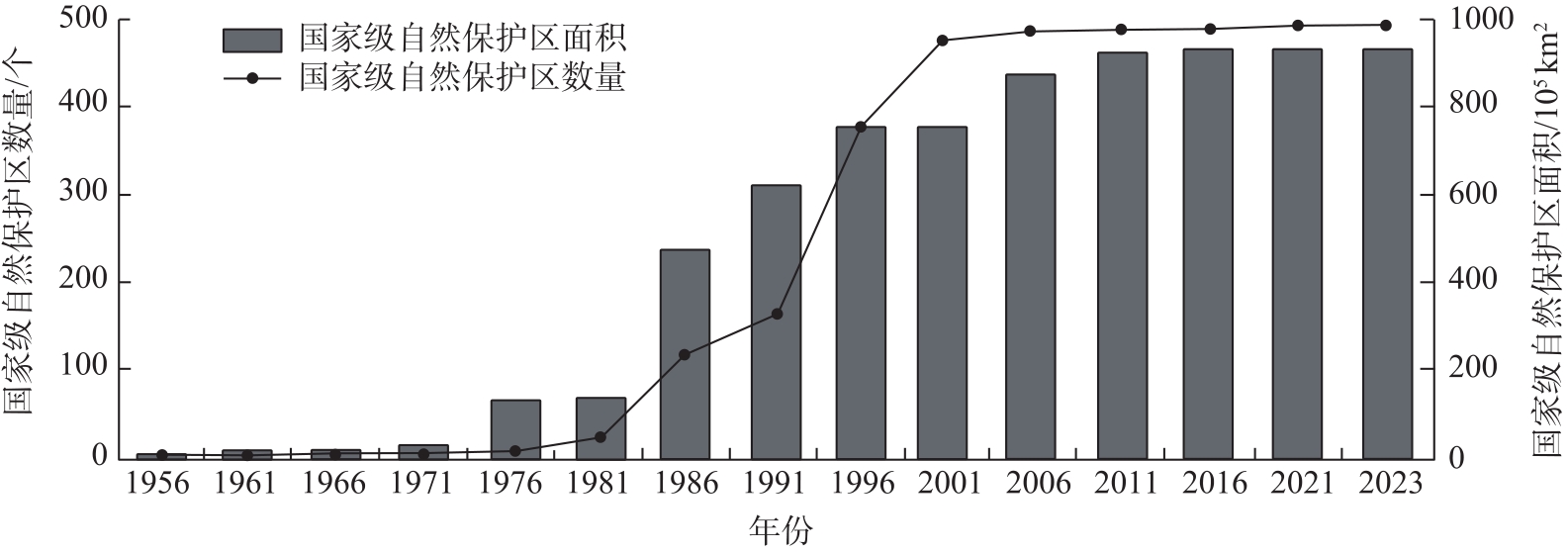
| [1] |
Xu J L, Sun G Q, Liu Y. Diversity and complexity in the forms and functions of protected areas in China[J]. Journal of International Wildlife Law & Policy, 2014, 17(3): 102-114.
|
| [2] |
欧阳志云, 杜傲, 徐卫华. 中国自然保护地体系分类研究[J]. 生态学报, 2020, 40(20): 7207-7215.
|
|
[Ouyang Zhiyun, Du Ao, Xu Weihua. Research on China’s protected area system classification[J]. Acta Ecologica Sinica, 2020, 40(20): 7207-7215. ]
|
| [3] |
王昌海. 改革开放40年中国自然保护区建设与管理: 成就、挑战与展望[J]. 中国农村经济, 2018(10): 93-106.
|
|
[Wang Changhai. The construction and management of China’s nature reserves in the past forty years of reform and opening-up: Achievements, challenges and prospects[J]. China Rural Economy, 2018(10): 93-106. ]
|
| [4] |
赵智聪, 王沛. 中国自然保护地连通性的重要意义与关键议题[J]. 风景园林, 2022, 29(7): 12-17.
|
|
[Zhao Zhicong, Wang Pei. Significance and key issues of protected area connectivity in China[J]. Landscape Architecture, 2022, 29(7): 12-17. ]
|
| [5] |
骆殿啟, 刘曙光. 自然保护区价值评判方法[J]. 资源开发与保护, 1992(4): 247-251.
|
|
[Luo Dianqi, Liu Shuguang. A method for evaluating the value of nature reserves[J]. Resource Development and Conservation, 1992(4): 247-251. ]
|
| [6] |
王安琪, 张钰, 刘佳伟, 等. 新疆甘家湖梭梭林国家级自然保护区植被群落多样性及空间分布格局[J]. 干旱区地理, 2024, 47(11): 1841-1851.
doi: 10.12118/j.issn.1000-6060.2024.133
|
|
[Wang Anqi, Zhang Yu, Liu Jiawei, et al. Vegetation community diversity and spatial distribution pattern in Ganjiahu saxoul national nature reserve, Xinjiang[J]. Arid Land Geography, 2024, 47(11): 1841-1851. ]
doi: 10.12118/j.issn.1000-6060.2024.133
|
| [7] |
张坤, 肖燕, 何振芳, 等. 基于SRTM DEM的祁连山自然保护区地形特征研究[J]. 干旱区地理, 2020, 43(6): 1559-1566.
|
|
[Zhang Kun, Xiao Yan, He Zhenfang, et al. Topography features of Qilian Mountains nature reserve based on SRTM DEM[J]. Arid Land Geography, 2020, 43(6): 1559-1566. ]
doi: 10.12118/j.issn.1000-6060.2020.06.17
|
| [8] |
马童慧, 吕偲, 雷光春. 中国自然保护地空间重叠分析与保护地体系优化整合对策[J]. 生物多样性, 2019, 27(7): 758-771.
doi: 10.17520/biods.2019087
|
|
[Ma Tonghui, Lü Cai, Lei Guangchun. The spatial overlapping analysis for China’s natural protected area and countermeasures for the optimization and integration of protected area system[J]. Biodiversity Science, 2019, 27(7): 758-771. ]
doi: 10.17520/biods.2019087
|
| [9] |
郭倩倩, 张志斌, 陈龙, 等. “流空间”视角下西北地区城市关联特征与网络格局分析[J]. 经济地理, 2023, 43(3): 88-99.
doi: 10.15957/j.cnki.jjdl.2023.03.010
|
|
[Guo Qianqian, Zhang Zhibin, Chen Long, et al. Characteristics and network structure of urban linkage in northwest China from the perspective of “flow space”[J]. Economic Geography, 2023, 43(3): 88-99. ]
doi: 10.15957/j.cnki.jjdl.2023.03.010
|
| [10] |
卢爱刚, 王圣杰. 中国自然保护区发展状况分析[J]. 干旱区资源与环境, 2010, 24(11): 7-11.
|
|
[Lu Aigang, Wang Shengjie. Analysis on the development of nature preserves of China[J]. Journal of Arid Land Resources and Environment, 2010, 24(11): 7-11. ]
|
| [11] |
田野, 罗静, 孙建伟, 等. 武汉城市圈内部空间联系及其轴-辐网络结构演化[J]. 地理科学进展, 2019, 38(7): 1093-1102.
doi: 10.18306/dlkxjz.2019.07.013
|
|
[Tian Ye, Luo Jing, Sun Jianwei, et al. Urban spatial linkages and the hub-spoke network structure in the Wuhan metropolitan area[J]. Progress in Geography, 2019, 38(7): 1093-1102. ]
doi: 10.18306/dlkxjz.2019.07.013
|
| [12] |
刘承良, 桂钦昌, 段德忠, 等. 全球科研论文合作网络的结构异质性及其邻近性机理[J]. 地理学报, 2017, 72(4): 737-752.
doi: 10.11821/dlxb201704014
|
|
[Liu Chengliang, Gui Qinchang, Duan Dezhong, et al. Structural heterogeneity and proximity mechanism of global scientific collaboration network based on co-authored papers[J]. Acta Geographica Sinica, 2017, 72(4): 737-752. ]
doi: 10.11821/dlxb201704014
|
| [13] |
解钰茜, 曾维华, 马冰然. 基于社会网络分析的全球自然保护地治理模式研究[J]. 生态学报, 2019, 39(4): 1394-1406.
|
|
[Xie Yuxi, Zeng Weihua, Ma Bingran. Social network analysis of governance types of global protected areas[J]. Acta Ecologica Sinica, 2019, 39(4): 1394-1406. ]
|
| [14] |
初楠臣, 吴相利, 张平宇, 等. 基于现实与虚拟流视角下的东北地区城市空间网络特征[J]. 经济地理, 2022, 42(5): 66-74.
doi: 10.15957/j.cnki.jjdl.2022.05.007
|
|
[Chu Nanchen, Wu Xiangli, Zhang Pingyu, et al. Urban spatial network characteristics from the perspectives of reality and virtual flow in northeast China[J]. Economic Geography, 2022, 42(5): 66-74. ]
doi: 10.15957/j.cnki.jjdl.2022.05.007
|
| [15] |
高吉喜, 徐梦佳, 邹长新. 中国自然保护地70年发展历程与成效[J]. 中国环境管理, 2019, 11(4): 25-29.
|
|
[Gao Jixi, Xu Mengjia, Zou Changxin. Development achievement of natural conservation in 70 years of new China[J]. Chinese Journal of Environmental Management, 2019, 11(4): 25-29. ]
|
| [16] |
Huang Y Z, Fu J, Wang W R, et al. Development of China’s nature reserves over the past 60 years: An overview[J]. Land Use Policy, 2019, 80: 224-232.
doi: 10.1016/j.landusepol.2018.10.020
|
| [17] |
闫颜, 王智, 高军, 等. 我国自然保护区地区分布特征及影响因素[J]. 生态学报, 2010, 30(18): 5091-5097.
|
|
[Yan Yan, Wang Zhi, Gao Jun, et al. Regional distribution characteristics of nature reserves and the influencing factors in China[J]. Acta Ecologica Sinica, 2010, 30(18): 5091-5097. ]
|
| [18] |
Sun S, Sang W, Axmacher J C. China’s national nature reserve network shows great imbalances in conserving the country’s mega-diverse vegetation[J]. Science of the Total Environment, 2020, 717: 137159, doi: 10.1016/j.scitotenv.2020.137159.
|
| [19] |
Xu B C, Pan J H. Spatial distribution characteristics of national protected areas in China[J]. Journal of Geographical Sciences, 2019, 29(12): 2047-2068.
doi: 10.1007/s11442-019-1704-0
|
| [20] |
赵文飞, 宗路平, 王梦君. 中国自然保护区空间分布特征研究[J]. 生态学报, 2024, 44(7): 2786-2799.
|
|
[Zhao Wenfei, Zong Luping, Wang Mengjun. Spatial distribution of nature reserves in China[J]. Acta Ecologica Sinica, 2024, 44(7): 2786-2799. ]
|
| [21] |
王哲骁. 整合保护导向下的武陵山区沅水流域传统村落集群空间网络构建研究[D]. 武汉: 华中农业大学, 2020.
|
|
[Wang Zhexiao. Research on the construction of spatial network of traditional village clusters in Yuanshui River Basin of Wuling Mountain area under the guidance of integrated protection[D]. Wuhan: Huazhong Agricultural University, 2020. ]
|
| [22] |
李晓肃, 邓武功, 李泽, 等. 自然保护地整合优化——思路、应对与探讨[J]. 中国园林, 2020, 36(11): 25-28.
|
|
[Li Xiaosu, Deng Wugong, Li Ze, et al. Integration and optimization of protected area: Thinking, response and discussion[J]. Chinese Landscape Architecture, 2020, 36(11): 25-28. ]
|
| [23] |
李永进, 汤玉喜, 黎蕾, 等. 湖南省自然保护地空间分布特征及其重叠关系分析[J]. 生态与农村环境学报, 2021, 37(12): 1540-1547.
|
|
[Li Yongjin, Tang Yuxi, Li Lei, et al. Analysis on spatial distribution characteristics and overlapping relationship of natural protected areas in Hunan Province[J]. Journal of Ecology and Rural Environment, 2021, 37(12): 1540-1547. ]
|
| [24] |
唐小平, 刘增力, 马炜. 我国自然保护地整合优化规则与路径研究[J]. 林业资源管理, 2020(1): 1-10.
|
|
[Tang Xiaoping, Liu Zengli, Ma Wei. A study on integration and optimization rules and paths for natural protected areas in China[J]. Forest and Grassland Resources Research, 2020(1): 1-10. ]
|
| [25] |
黄秋淞, 何浩. 耦合生态系统服务和景观连通性的环塔里木盆地绿洲区生态安全格局研究[J]. 干旱区地理, 2024, 47(10): 1745-1754.
doi: 10.12118/j.issn.1000-6060.2024.022
|
|
[Huang Qiusong, He Hao. Ecological security pattern of the oasis area around the Tarim Basin based on coupled ecosystem services and landscape connectivity[J]. Arid Land Geography, 2024, 47(10): 1745-1754. ]
doi: 10.12118/j.issn.1000-6060.2024.022
|
 ), 常凯1,2(