干旱区地理 ›› 2024, Vol. 47 ›› Issue (2): 332-342.doi: 10.12118/j.issn.1000-6060.2023.148
唐钰婷1,2( ), 杜宏茹1,2()
收稿日期:2023-04-04
修回日期:2023-05-23
出版日期:2024-02-25
发布日期:2024-03-14
通讯作者:
杜宏茹(1974-),女,研究员,主要从事城市地理、城乡与区域发展研究. E-mail: duhongru@sina.cn作者简介:唐钰婷(1997-),女,硕士研究生,主要从事城市地理研究. E-mail: tangyuting20@mails.ucas.ac.cn
基金资助:
TANG Yuting1,2(), DU Hongru1,2()
Received:2023-04-04
Revised:2023-05-23
Published:2024-02-25
Online:2024-03-14
摘要:
社区生活圈与居民生活息息相关,是城市基层公共服务设施建设的基本单元,是城市更新的重要抓手。科学划定社区生活圈范围,综合测度其建设水平,为推进社区生活圈建设和实现公共资源高效配置提供理论探索,为地理环境与居民行为关系研究提供新的视角及案例。论文基于生活圈科学划定-建设水平评价的研究思路,通过合并步行规划时空圈和Mapbox时空圈数据探索社区生活圈划定的优化方法,从设施布局、空间可获得性和居民满意度等维度构建生活圈建设水平综合测度指标体系,并以乌鲁木齐市为例,开展实证研究。结果表明:(1) 合并步行规划时空圈和Mapbox时空圈数据来划分生活圈范围,可以提升划分结果的时效性和边界准确性。(2) 设施布局密度和人均享用量对生活圈建设水平的影响较为显著。(3) 乌鲁木齐市15 min步行生活圈平均半径为812.75 m,平均面积为2.10 km2,老城区建设水平高于新建城区,商服类建设水平高于健康管理、教育、出行类等设施,设施数量不足和布局不均衡是造成差异的主要原因。
唐钰婷, 杜宏茹. 社区生活圈划分及建设水平综合测度方法——以乌鲁木齐市为例[J]. 干旱区地理, 2024, 47(2): 332-342.
TANG Yuting, DU Hongru. Spatial scope of community living circle and comprehensive measurement method of construction level: Urumqi City as an example[J]. Arid Land Geography, 2024, 47(2): 332-342.
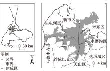
图1
研究区示意图"
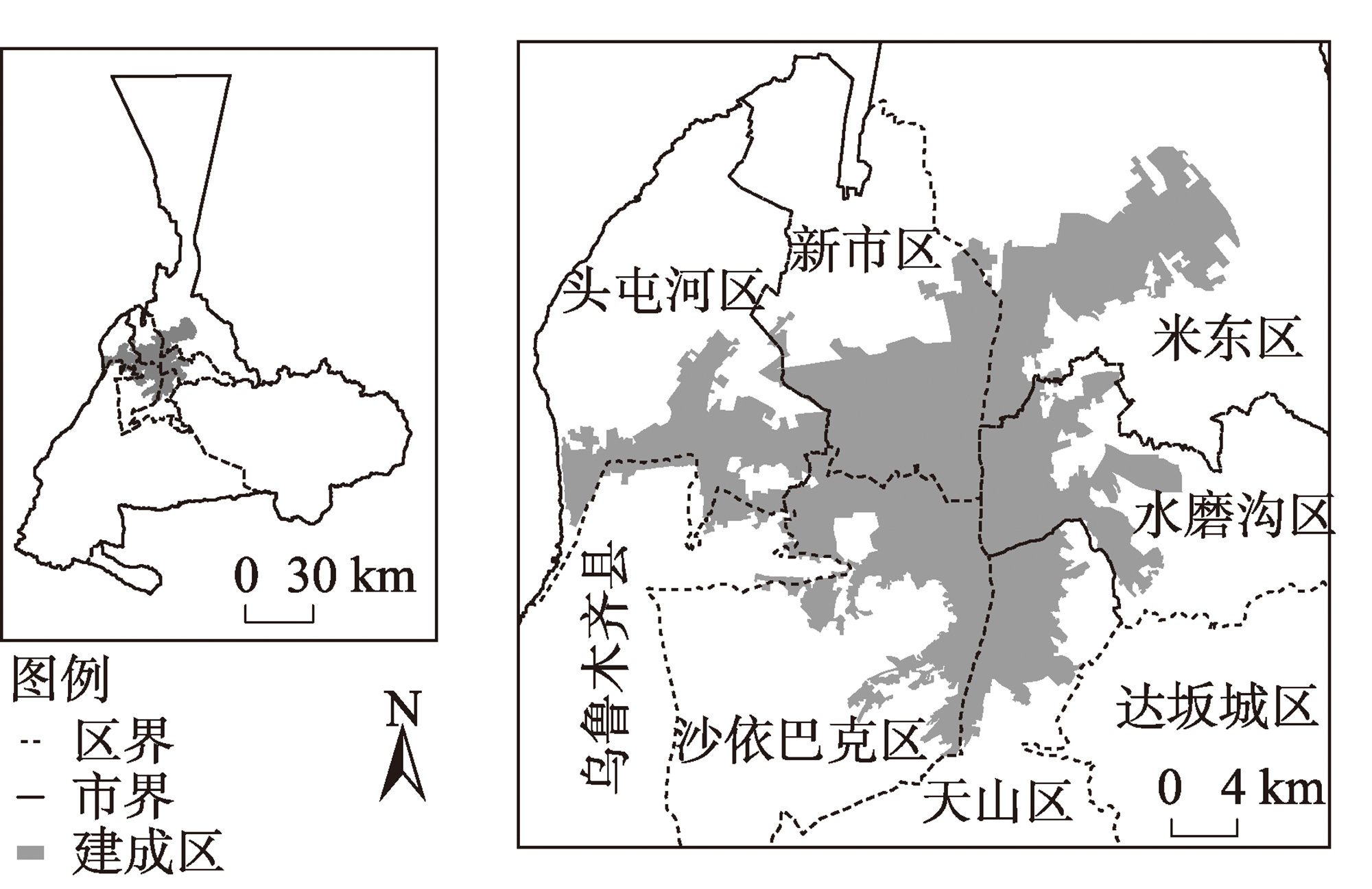
表1
社区生活圈公共服务设施服务半径及获取数量"
| 设施类别 | 设施名称 | 服务半径/m | 获取数量/个 |
|---|---|---|---|
| 健康管理 | 卫生服务中心(站) | 1000 | 74 |
| 诊所 | 1000 | 401 | |
| 专科医院、综合医院 | 1000 | 255 | |
| 养老院 | 1000 | 71 | |
| 教育 | 初中 | 1000 | 205 |
| 小学 | 500 | 157 | |
| 幼儿园 | 300 | 366 | |
| 托儿所 | 1000 | 374 | |
| 文化活动 | 文化活动中心 | 1000 | 497 |
| 文化活动站 | 500 | 120 | |
| 文化展示场馆 | 1000 | 57 | |
| 运动 | 公园、广场 | 1000 | 79 |
| 体育馆(场) | 1000 | 133 | |
| 健身房 | 1000 | 196 | |
| 商业服务 | 便利店 | 1000 | 371 |
| 商场 | 1000 | 136 | |
| 菜市场 | 500 | 720 | |
| 餐饮设施 | 1000 | 5259 | |
| 快递点 | 1000 | 1069 | |
| 市政设施 | 派出所 | 800 | 114 |
| 公共厕所 | 1000 | 295 | |
| 垃圾转运站 | 1000 | 7 | |
| 消防站 | 1000 | 47 | |
| 日常出行 | 公交车站 | 1000 | 1200 |
| 轨道交通站点 | 800 | 65 | |
| 停车场(库) | 1000 | 1024 |
表2
城市居民对社区生活圈相关设施建设和服务满意度调查问题"
| 设施类别 | 问题选取 |
|---|---|
| 健康管理 | 您对健康的总体满意度? |
| 教育 | 您所在城市中小学校教学质量怎么样? |
| 文化活动 | 您认为所在城市文化设施使用方便吗? |
| 运动 | 您对城市开敞空间(公园、广场、步行街等)的满意度? |
| 商业服务 | 您认为日常就近购物方便吗? |
| 市政设施 | 您对城市公共设施供给的总体满意度? |
| 日常出行 | 您对城市交通便捷的总体满意度? |

图2
生活圈示意图 注:图2b中网格上的数字为小区步行至该网格所需时间,随时间变长,网络颜色变深。"

表3
公共服务设施评价体系及指标计算公式"
| 目标层 | 准则层 | 指标层 | 计算公式 | 公式说明 |
|---|---|---|---|---|
| 客观 | 空间布局 | 点密度 | ||
| 覆盖率 | ||||
| 可获得性 | 最近距离 | |||
| 人均享有量 | ||||
| 主观 | 满意程度 | 满意度占比 |
图3
乌鲁木齐市中心城区社区生活圈划定"


图4
公共服务设施指标层得分比重及得分"
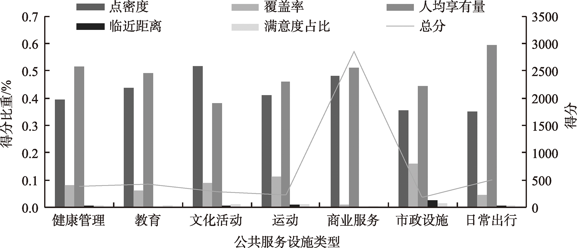
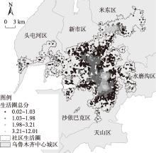
图5
生活圈得分"

表4
各区生活圈指标层得分"
| 指标层 | 米东区 | 沙依巴克区 | 水磨沟区 | 天山区 | 头屯河区 | 新市区 |
|---|---|---|---|---|---|---|
| 点密度 | 166.87 | 500.91 | 554.13 | 567.17 | 28.23 | 455.44 |
| 人均享有量 | 535.83 | 458.99 | 466.60 | 422.56 | 94.49 | 367.96 |
| 覆盖率 | 20.77 | 70.20 | 47.55 | 63.30 | 2.45 | 75.86 |
| 临近距离 | 2.71 | 3.78 | 3.11 | 2.65 | 1.39 | 3.46 |
| [1] |
方创琳. 中国新型城镇化高质量发展的规律性和重点方向[J]. 地理研究, 2019, 38(1): 13-22.
doi: 10.11821/dlyj020180445 |
|
[ Fang Chuanglin. Basic rules and key paths for high-quality development of the new urbanization in China[J]. Geographical Research, 2019, 38(1): 13-22. ]
doi: 10.11821/dlyj020180445 |
|
| [2] | GB 50180-2018. 城市居住区规划设计标准[S]. 北京: 中国建筑工业出版社. 2018. |
| [ GB 50180-2018. Standard for urban residential area planning and design[S]. Beijing: China Construction Industry Press. 2018. ] | |
| [3] | TD/T1062-2021. 社区生活圈规划技术指南 [S]. 北京: 地质出版社, 2021. |
| [ TD/T1062-2021. Spatial planning guidance to community life unit[S]. Beijing: Geology Press, 2021. ] | |
| [4] | 上海市规划和国土资源管理局,上海市规划编审中心, 上海市城市规划设计研究院. 上海15分钟社区生活圈规划研究与实践[M]. 上海: 上海人民出版社, 2017: 21-155. |
| [ Shanghai Municipal Administration of Planning and Land Resources, Shanghai Planning and Review Center, Shanghai Urban Planning and Design Research Institute. Shanghai 15-minute community life circle planning research and practice[M]. Shanghai: Shanghai People’s Publishing House, 2017: 21-155. ] | |
| [5] | 卞硕尉, 吕大伟, 陈楠. 面向实施与管理的15分钟社区生活圈规划探索——以济南市为例[C]// 中国城市规划学会, 杭州市人民政府. 共享与品质——2018中国城市规划年会论文集(20住房建设规划). 北京: 中国建筑工业出版社, 2018: 12. |
| [ Bian Shuoyu, Lü Dawei, Chen Nan. Exploration of implementation-and management-oriented 15-minute community living circle planning: Jinan City as an example[C]// Chinese Society of Urban Planning, Hangzhou Municipal People’s Government. Sharing and Quality:Proceedings of the 2018 China Urban Planning Annual Conference (20 Housing Construction Planning). Beijing: China Construction Industry Press, 2018: 12. ] | |
| [6] | 新疆维吾尔自治区住房和城乡建设厅. 15分钟城市居民活动圈建设技术标准[EB/OL]. [2021-02-09]. http://zjt.xinjiang.gov.cn/xjzjt/c113382/202102/a91efae9bfb046729cff2a54ac7ab4ae.shtml. |
| [ Department of Housing and Urban-Rural Development of Xinjiang Uygur Autonomous Region. Technical standard for construction of 15-minute urban residents’ activity circle[EB/OL]. [2021-02-09]. http://zjt.xinjiang.gov.cn/xjzjt/c113382/202102/a91efae9bfb046729cff2a54ac7ab4ae.shtml. ] | |
| [7] | 中华人民共和国人民政府. 我国将聚焦“一店一早”“一菜一修”“一老一小”推动一刻钟便民生活圈建设[EB/OL]. [2023-03-202]. http://www.gov.cn/xinwen/2023-03/02/content_5744202.htm. |
| [ The Central People’s Government of the People’s Republic of China. China will focus on “one store, one morning” “one dish, one repair” “one old man, one small” to promote the construction of a quarter-hour convenient living circle[EB/OL]. [2023-03-202]. http://www.gov.cn/xinwen/2023-03/02/content_5744202.htm. ] | |
| [8] |
Brown J R, Morris E A, Taylor B D. Planning for cars in cities: Planners, engineers, and freeways in the 20thcentury[J]. Journal of the American Planning Association. 2009, 75(2): 161-177.
doi: 10.1080/01944360802640016 |
| [9] | Holiencinova M, Kadekova Z, Holota T, et al. Smart solution of traffic congestion through bike sharing system in a small city[J]. Mobile Networks & Applications, 2020, 25(3): 868-875. |
| [10] | Carlos M, Zaheer A, Didier C, et al. Introducing the “15-Minute City”: Sustainability, resilience and place identity in future post-pandemic cities[J]. Smart City, 2021, 4: 93-111. |
| [11] | Allam Z, Bibri S E, Chabaud D, et al. The “15-Minute City” concept can shape a net-zero urban future[J]. Humanities and Social Sciences Communications, 2022, 9(1): 126, doi: 10.1057/s41599-022-01145-0. |
| [12] | De Vos J. The effect of Covid-19 and subsequent social distancing on travel behavior[J]. Transportation Research Interdisciplinary Perspectives, 2020, 5: 100121, doi: 10.1016/j.trip.2020.100121. |
| [13] | 肖作鹏, 韩来伟, 柴彦威. 生活圈规划嵌入国土空间规划的思考[J]. 规划师, 2022, 38(9): 145-151. |
| [ Xiao Zuopeng, Han Laiwei, Chai Yanwei. Review on embedding life cycle planning in territorial space planning system[J]. Planners, 2022, 38(9): 145-151. ] | |
| [14] | 钱征寒, 刘泉, 黄丁芳. 15分钟生活圈的三个尺度和规划趋势[J]. 国际城市规划, 2022, 37(5): 63-70. |
| [ Qian Zhenghan, Liu Quan, Huang Dingfang. Three scales and planning trends of 15-minute life circle[J]. Urban Planning International, 2022, 37(5): 63-70. ] | |
| [15] | 萧敬豪, 周岱霖, 胡嘉佩. 基于决策树原理的社区生活圈测度与评价方法——以广州市番禺区为例[J]. 规划师, 2018, 34(3): 91-96. |
| [ Xiao Jinghao, Zhou Dailin, Hu Jiapei. Measurement and evaluation method of community life-cycle based on decision tree theory: Panyu District of Guangzhou[J]. Planners, 2018, 34(3): 91-96. ] | |
| [16] |
赵鹏军, 罗佳, 胡昊宇. 基于大数据的生活圈范围与服务设施空间匹配研究——以北京为例[J]. 地理科学进展, 2021, 40(4): 541-553.
doi: 10.18306/dlkxjz.2021.04.001 |
|
[ Zhao Pengjun, Luo Jia, Hu Haoyu. Spatial match between residents’ daily life circle and public service facilities using big data analytics: A case of Beijing[J]. Progress in Geography, 2021, 40(4): 541-553. ]
doi: 10.18306/dlkxjz.2021.04.001 |
|
| [17] | 柴彦威, 李春江, 夏万渠, 等. 城市社区生活圈划定模型——以北京市清河街道为例[J]. 城市发展研究, 2019, 26(9): 1-8, 68. |
| [ Chai Yanwei, Li Chunjiang, Xia Wanqu, et al. Study on the delineation model of urban community life circle: Based on Qinghe District in Haidian District, Beijing[J]. Urban Studies, 2019, 26(9): 1-8, 68. ] | |
| [18] | 李姝雅. 15分钟生活圈居住区公共服务设施配置指标优化研究[D]. 西安:西安建筑科技大学, 2020. |
| [ Li Shuya. Research on the optimization of public service facility configuration index of 15-minute living circle: A case research of Xi’an City[D]. Xi’an: Xi’an University of Architecture and Technology, 2020. ] | |
| [19] | 王影. 时空圈视角下西安中心城区居住区公共服务设施布点研究[D]. 西安: 西安建筑科技大学, 2021. |
| [ Wang Ying. Research on the distribution of public service facilities in the residential area of Xi’an central city from the perspective of time and space circle[D]. Xi’an: Xi’an University of Architecture and Technology, 2021. ] | |
| [20] | 李佳嘉, 何林海, 邓子怡, 等. 15分钟健康生活圈公共服务设施配置水平评价研究——以长沙市开福区、岳麓区、天心区为例[J]. 城市建筑, 2022, 19(11): 22-26. |
| [ Li Jiajia, He Linhai, Deng Ziyi, et al. Study on the evaluation of public service facilities configuration level in 15-minute healthy life circle: Cases of Kaifu District, Yuelu District and Tianxin District in Changsha[J]. Urbanism and Architecture, 2022, 19(11): 22-26. ] | |
| [21] | 卢银桃, 侯成哲, 赵立维, 等. 15分钟公共服务水平评价方法研究[J]. 规划师, 2018, 34(9): 106-110. |
| [ Lu Yintao, Hou Chengzhe, Zhao Liwei, et al. Evaluation of 15-minute public service level[J]. Planners, 2018, 34(9): 106-110. ] | |
| [22] |
韩增林, 董梦如, 刘天宝, 等. 社区生活圈基础教育设施空间可达性评价与布局优化研究——以大连市沙河口区为例[J]. 地理科学, 2020, 40(11): 1774-1783.
doi: 10.13249/j.cnki.sgs.2020.11.002 |
|
[ Han Zenglin, Dong Mengru, Liu Tianbao, et al. Spatial accessibility evaluation and layout optimization of basic education facilities in community life circle: A case study of Shahekou in Dalian[J]. Scientia Geographica Sinica, 2020, 40(11): 1774-1783. ]
doi: 10.13249/j.cnki.sgs.2020.11.002 |
|
| [23] | 沈育辉, 童滋雨. 人本尺度下社区生活圈便利性评估方法研究[J]. 南方建筑, 2022(7): 72-80. |
| [ Shen Yuhui, Tong Ziyu. A convenient method of evaluating community life circles on the human-oriented scale[J]. Southern Architecture, 2022(7): 72-80. ] | |
| [24] | 赵万民, 方国臣, 王华. 生活圈视角下的住区适老化步行空间体系构建[J]. 规划师, 2019, 35(17): 69-78. |
| [ Zhao Wanmin, Fang Guochen, Wang Hua. Creating as senior friendly pedestrian space system from life circle viewpoint[J]. Planners, 2019, 35(17): 69-78. ] | |
| [25] | 申悦, 柴彦威. 基于GPS数据的北京市郊区巨型社区居民日常活动空间[J]. 地理学报, 2013, 68(4): 506-516. |
|
[ Shen Yue, Chai Yanwei. Daily activity space of suburban mega-community residents in Beijing based on GPS data[J]. Acta Geographica Sinica, 2013, 68(4): 506-516. ]
doi: 10.11821/xb201304006 |
|
| [26] | 周弦. 15分钟社区生活圈视角的单元规划公共服务设施布局评估: 以上海市黄浦区为例[J]. 城市规划学刊, 2020(1): 57-64. |
| [ Zhou Xian. Assessing the distribution of public service facilities in unit planning based on the perspective of the 15-minute community-life circle: Evidence from Huangpu District of Shanghai[J]. Urban Planning Forum, 2020(1): 57-64. ] | |
| [27] | 陈鲁凤, 李成名, 戴昭鑫, 等. 居民区“15分钟生活圈”公共服务设施配置研究[J]. 测绘科学, 2022, 47(1): 236-244. |
| [ Chen Lufeng, Li Chengming, Dai Zhaoxin, et al. Research on spatial configuration of public service facilities in 15-minute life circle of residential district[J]. Science of Surveying and Mapping, 2022, 47(1): 236-244. ] | |
| [28] |
常飞, 王录仓, 马玥, 等. 城市公共服务设施与人口是否匹配?——基于社区生活圈的评估[J]. 地理科学进展, 2021, 40(4): 607-619.
doi: 10.18306/dlkxjz.2021.04.006 |
|
[ Chang Fei, Wang Lucang, Ma Yue, et al. Do urban public service facilities match population demand? Assessment based on community life circle[J]. Progress in Geography, 2021, 40(4): 607-619. ]
doi: 10.18306/dlkxjz.2021.04.006 |
|
| [29] |
赵鹏军, 罗佳, 胡昊宇. 基于大数据的老年人生活圈及设施配置特征分析——以北京市为例[J]. 地理科学, 2022, 42(7): 1176-1186.
doi: 10.13249/j.cnki.sgs.2022.07.005 |
|
[ Zhao Pengjun, Luo Jia, Hu Haoyu. Character of the elderly’s life circle and public service facilities configuration by using big data: A case of Beijing[J]. Scientia Geographica Sinica, 2022, 42(7): 1176-1186. ]
doi: 10.13249/j.cnki.sgs.2022.07.005 |
|
| [30] | 马文军, 李亮, 顾娟, 等. 上海市15分钟生活圈基础保障类公共服务设施空间布局及可达性研究[J]. 规划师, 2020, 36(20): 11-19. |
| [ Ma Wenjun, Li Liang, Gu Juan, et al. Research on spatial layout and accessibility of infrastructural public service facilities in the 15 minute life circle, Shanghai[J]. Planners, 2020, 36(20): 11-19. ] | |
| [31] |
Lucas J C, Shira I D, Bess H M. Validation of walk score for estimating access to walkable amenities[J]. British Journal of Sports Medical, 2011, 45: 1144-1148.
doi: 10.1136/bjsm.2009.069609 |
| [32] | C40 Cities. C40 mayors’ agenda for a green and just recovery[EB/OL]. [2020-07-20]. https://c40.org/wp-content/uploads/2021/07/2093_C40_Cities_2020_Mayors_Agenda_for_a_Green_and_Just_Recovery.original.pdf. |
| [33] | Federica G, Carmela G, Floriana Z, et al. Urban accessibility in a 15-minute city: A measure in the city of Naples, Italy[J]. Transportation Research Procedia, 2022, 60: 379-385. |
| [34] | Willberg E, Fink C, Toivonen T. The 15-minute city for all? Measuring individual and temporal variations in walking accessibility[J]. Journal of Transport Geography, 2023, 106: 103521, doi: 10.1016/j.jtrangeo.2022.103521. |
| [35] | Barbieri L, D’Autilia R, Marrone P, et al. Graph representation of the 15-minute city: A comparison between Rome, London, and Paris[J]. Sustainability, 2023, 15(4): 3772, doi: 10.3390/su15043772. |
| [36] |
Tran M, Draeger C. A data-driven complex network approach for planning sustainable and inclusive urban mobility hubs and services[J]. Environment and Planning B: Urban Analytics and City Science, 2021, 48(9): 2726-2742.
doi: 10.1177/2399808320987093 |
| [37] | Logan T M, Hobbs M H, Conrow L C, et al. The x-minute city: Measuring the 10, 15, 20-minute city and an evaluation of its use for sustainable urban design[J]. Cities, 2022, 131: 103924, doi: 10.1016/j.cities.2022.103924. |
| [38] |
Logan T M, Williams T G, Guikema S D, et al. Evaluating urban accessibility: Leveraging open-source data and analytics to overcome existing limitations[J]. Environment and Planning B: Urban Analytics and City Science, 2019, 46(5): 897-912.
doi: 10.1177/2399808317736528 |
| [39] | 肖凤玲, 杜宏茹, 张小雷. “15分钟生活圈”视角下住宅小区与公共服务设施空间配置评价——以乌鲁木齐市为例[J]. 干旱区地理, 2021, 44(2): 574-583. |
| [ Xiao Fengling, Du Hongru, Zhang Xiaolei. Evaluation of spatial allocation of residential quarters and public service facilities based on the perspective of “15 minutes life circle”: A case study of Urumqi City[J]. Arid Land Geography, 2021, 44(2): 574-583. ] | |
| [40] | 王德, 傅英姿. 手机信令数据助力上海市社区生活圈规划[J]. 上海城市规划, 2019(6): 23-29. |
| [ Wang De, Fu Yingzi. Mobile signaling data helps Shanghai community life circle planning[J]. Shanghai Urban Planning Review, 2019(6): 23-29. ] | |
| [41] | 牛强, 夏彬鑫, 钟雨妮, 等. 社区生活圈的线上线下化特征、差异和规划策略——以武汉市典型社区为例[J]. 上海城市规划, 2022(5): 112-118. |
| [ Niu Qiang, Xia Binxin, Zhong Yuni, et al. Characteristics, differences and planning strategies of online and offline community living circle: A case study of typical communities in Wuhan[J]. Shanghai Urban Planning Review, 2022(5): 112-118. ] |
| [1] | 彭娅, 王娟娟, 王珊珊, 田柳兰, 刘婕, 毋兆鹏. 生态安全视角下乌鲁木齐市土地利用冲突时空格局演变分析[J]. 干旱区地理, 2024, 47(1): 81-92. |
| [2] | 田柳兰, 王珊珊, 毋兆鹏. 基于多时相遥感数据的乌鲁木齐市生态安全格局构建[J]. 干旱区地理, 2023, 46(7): 1155-1165. |
| [3] | 梁樑, 郭晓淞, 陈汉杰, 徐皓帆, 周衍波, 谢邵文, 杨芬, 韦朝阳. 乌鲁木齐市核心城区绿地土壤重金属累积特征及生态风险[J]. 干旱区地理, 2023, 46(11): 1868-1878. |
| [4] | 隋露, 蒲春玲, 刘志有, 柏鹏飞, 刘涛. 基于PLUS模型的乌鲁木齐市生态服务价值权衡协同探究[J]. 干旱区地理, 2023, 46(1): 159-168. |
| [5] | 陈晨,汪丽,程林. 北方农牧交错带少数民族语地名文化脆弱性评价体系构建与实证[J]. 干旱区地理, 2022, 45(3): 976-985. |
| [6] | 李桉孛,万瑜,张俊,李如琦,芒苏尔·艾热提,李娜. 1961—2019年乌鲁木齐市暴雪环流分型及其成因分析[J]. 干旱区地理, 2022, 45(2): 379-388. |
| [7] | 赵永玉,阿里木江·卡斯木,高鹏文,梁洪武. 基于地理探测器的乌鲁木齐市城区扩展及影响因素分析[J]. 干旱区地理, 2021, 44(6): 1729-1739. |
| [8] | 苗运玲,宫恒瑞,王健,葛怡成,李如琦. 2012-2019年乌鲁木齐市夏季降水日变化特征[J]. 干旱区地理, 2021, 44(5): 1222-1230. |
| [9] | 肖凤玲,杜宏茹,张小雷. “15分钟生活圈”视角下住宅小区与公共服务设施空间配置评价——以乌鲁木齐市为例[J]. 干旱区地理, 2021, 44(2): 574-583. |
| [10] | 陈洪星, 杨德刚, 徐红涛, 霍金炜 . 基于 POI 的住宿业时空格局演化及与 旅游景点的空间关联研究[J]. 干旱区地理, 2020, 43(5): 1382-1390. |
| [11] | 帕丽达·牙合甫, 杨鹏月. 乌鲁木齐市近几年大气颗粒物中重金属的浓度特征[J]. 干旱区地理, 2019, 42(3): 492-498. |
| [12] | 柳雨杉, 董 晔. 基于指数分析法的乌鲁木齐市居住格局研究[J]. 干旱区地理, 2019, 42(3): 698-705. |
| [13] | 葛欢欢, 武胜利, 吕婷, 李京龙, 夏诗书, 夏黎. 气象因子对乌鲁木齐市一次重污染天气过程影响研究[J]. 干旱区地理, 2018, 41(3): 601-607. |
| [14] | 高宇潇, 刘志辉, 王敬哲. 乌鲁木市PM2.5浓度与MODIS气溶胶光学厚度相关性分析[J]. 干旱区地理, 2018, 41(2): 298-305. |
| [15] | 欧海燕, 赵鸿雁, 辛冲冲. 城市荒山开发模式融合演变理论探讨——以乌鲁木齐市为例[J]. 干旱区地理, 2016, 39(3): 647-653. |
|
||