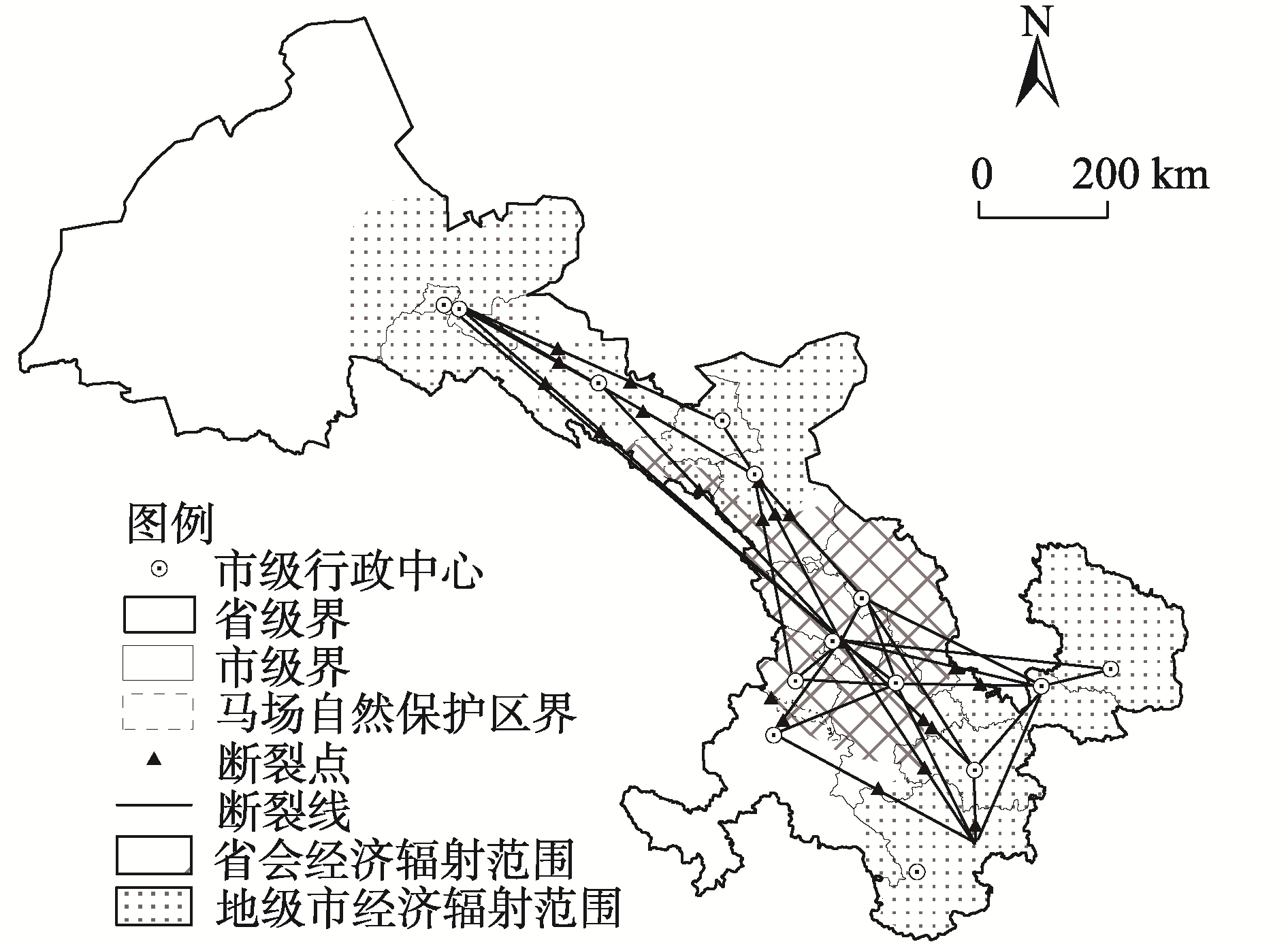
| [1] |
段进, 赵民, 赵燕菁, 等. “国土空间规划体系战略引领与刚性管控的关系”学术笔谈[J]. 城市规划学刊, 2021(2): 6-14.
|
|
[Duan Jin, Zhao Min, Zhao Yanjing, et al. Symposium on relationship between strategic guidance and regulatory rigidity of the territorial spatial planning system[J]. Urban Planning Forum, 2021(2): 6-14.]
|
| [2] |
牛叔文, 张馨, 董建梅, 等. 基于主体功能分区的空间分析——以甘肃省为例[J]. 经济地理, 2010, 30(5): 732-737.
|
|
[Niu Shuwen, Zhang Xin, Dong Jianmei, et al. Spatial analysis based on major functional oriented zoning: A case study of Gansu Province[J]. Economic Geography, 2010, 30(5): 732-737.]
|
| [3] |
樊君第. “新丝绸之路经济带”背景下甘肃省城市竞争力排名的实证研究[J]. 知识经济, 2015(14): 24-25.
|
|
[Fan Jundi. An empirical study on urban competitive ranking of Gansu Province under the background of “New Silk Road Economic Belt”[J]. Knowledge Economy, 2015(14): 24-25.]
|
| [4] |
杨滨章. 哥本哈根“手指规划”产生的背景与内容[J]. 城市规划, 2009, 33(8): 52-58, 102.
|
|
[Yang Binzhang. Evolution and analysis of Copenhagen finger plan[J]. City Planning Review, 2009, 33(8): 52-58, 102.]
|
| [5] |
木内信藏. 都市地理学研究[M]. 东京: 古今书院, 1951.
|
|
[Kiuchi Nobuzo. Urban geography study[M]. Tokyo: Ancient and Modern Academy, 1951.]
|
| [6] |
张德胜, 金耀基, 陈海文, 等. 论中庸理性: 工具理性、价值理性和沟通理性之外[J]. 社会学研究, 2001(2): 33-48.
|
|
[Zhang Desheng, Jin Yaoji, Chen Haiwen, et al. Zhongyong mode: Beyond the instrumental rationality, value rationality, and communicative rationality[J]. Sociological Studies, 2001(2): 33-48.]
|
| [7] |
杜坤, 田莉. 城市战略规划的实施框架与内容: 来自大伦敦实施规划的启示[J]. 国际城市规划, 2016, 31(4): 90-96.
doi: 10.22217/upi
|
|
[Du Kun, Tian Li. The implementation framework and content of the city strategic planning: Implication from the London implementation plan[J]. Urban Planning International, 2016, 31(4): 90-96.]
doi: 10.22217/upi
|
| [8] |
Liu H, Fan J, Yang L I. “America 2050” strategic spatial planning and its inspiration to China[J]. Geographical Research, 2013, 32(1): 90-98.
|
| [9] |
陆大道. 区城发展及其空间结构[M]. 北京: 科学出版社, 1995.
|
|
[Lu Dadao. District and urban development and its spatial structure[M]. Beijing: Science Press, 1995.]
|
| [10] |
李裕瑞, 王婧, 刘彦随, 等. 中国“四化”协调发展的区域格局及其影响因素[J]. 地理学报, 2014, 69(2): 199-212.
doi: 10.11821/dlxb201402005
|
|
[Li Yurui, Wang Jing, Liu Yansui, et al. Spatial pattern and influencing factors of the coordination development of industrialization, informatization, urbanization and agricultural modernization in China: A prefecture level exploratory spatial data analysis[J]. Acta Geographica Sinica, 2014, 69(2): 199-212.]
doi: 10.11821/dlxb201402005
|
| [11] |
方创琳. 中国城市群研究取得的重要进展与未来发展方向[J]. 地理学报, 2014, 69(8): 1130-1144.
doi: 10.11821/dlxb201408009
|
|
[Fang Chuanglin. Progress and the future direction of research into urban agglomeration in China[J]. Acta Geographica Sinica, 2014, 69(8): 1130-1144.]
doi: 10.11821/dlxb201408009
|
| [12] |
李芝倩, 樊士德. 长三角城市群网络结构研究——基于社会网络分析方法[J]. 华东经济管理, 2021, 35(6): 31-41.
|
|
[Li Zhiqian, Fan Shide. Research on network structure of Yangtze River Delta urban agglomeration: Based on social network analysis[J]. East China Economic Management, 2021, 35(6): 31-41.]
|
| [13] |
崔万田, 王淑伟. 京津冀区域经济联系强度与网络结构分析[J]. 技术经济与管理研究, 2021(4): 117-121.
|
|
[Cui Wantian, Wang Shuwei. An analysis of the intensity of economic ties and network structure in Beijing-Tianjin-Hebei region[J]. Journal of Technical Economics & Management, 2021(4): 117-121.]
|
| [14] |
曹晨, 黄贤金. 多要素流视角下黄河“几”字弯都市圈空间网络结构及影响因素研究[J]. 干旱区地理, 2023, 44(6): 993-1003.
|
|
[Cao Chen, Huang Xianjin. Spatial network structure and its influencing factors of Jiziwan Metropolitan Area of the Yellow River from the perspective of multi-dimensional feature flow[J]. Arid Land Geography, 2023, 44(6): 993-1003.]
|
| [15] |
郝修宇, 徐培玮. 基于百度指数和引力模型的城市网络对比——以京津冀城市群为例[J]. 北京师范大学学报(自然科学版), 2017, 53(4): 479-485.
|
|
[Hao Xiuyu, Xu Peiwei. Comparison of urban networks by Baidu index and gravity model: A study of Jing-Jin-Ji urban agglomeration[J]. Journal of Beijing Normal University (Natural Science Edition), 2017, 53(4): 479-485.]
|
| [16] |
冯兴华, 修春亮, 刘志敏, 等. 东北地区城市网络层级演变特征分析——基于铁路客运流视角[J]. 地理科学, 2018, 38(9): 1430-1438.
doi: 10.13249/j.cnki.sgs.2018.09.005
|
|
[Feng Xinghua, Xiu Chunliang, Liu Zhimin, et al. Characteristics of urban network hierarchy evolution based on the perspective of railway passenger transport in northeast China[J]. Scientia Geographica Sinica, 2018, 38(9): 1430-1438.]
doi: 10.13249/j.cnki.sgs.2018.09.005
|
| [17] |
冯兴华, 修春亮, 白立敏, 等. 基于公路交通流视角的吉林省城镇中心性及影响因素[J]. 经济地理, 2019, 39(1): 64-72.
|
|
[Feng Xinghua, Xiu Chunliang, Bai Limin, et al. Urban centrality and influencing factors in Jilin Province from the perspective of highway traffic flow[J]. Economic Geography, 2019, 39(1): 64-72.]
|
| [18] |
郑龙飞, 顾伟男, 龙奋杰, 等. 不同流视角下的贵州省空间网络结构及形成机制分析[J]. 地理科学, 2020, 40(6): 939-947.
doi: 10.13249/j.cnki.sgs.2020.06.009
|
|
[Zheng Longfei, Gu Weinan, Long Fenjie, et al. The urban network structure and influential mechanism of Guizhou Province from the perspective of various flows[J]. Scientia Geographica Sinica, 2020, 40(6): 939-947.]
doi: 10.13249/j.cnki.sgs.2020.06.009
|
| [19] |
朱道才, 陆林, 晋秀龙, 等. 基于引力模型的安徽城市空间格局研究[J]. 地理科学, 2011, 31(5): 551-556.
|
|
[Zhu Daocai, Lu Lin, Jin Xiulong, et al. Spatial patterns of city in Anhui Province based on gravity model[J]. Scientia Geogrophica Sinica, 2011, 31(5): 551-556.]
|
| [20] |
张庭伟. 1990年代中国城市空间结构的变化及其动力机制[J]. 城市规划, 2001(7): 7-14.
|
|
[Zhang Tingwei. The urban restructuring of Chinese cities in 1990s and its dynamic mechanism[J]. City Planning Review, 2001(7): 7-14.]
|
| [21] |
陈晓华, 吴仕嫱. 南京-合肥双都市圈区域空间格局研究——基于城市流的视角[J]. 华东经济管理, 2021, 35(11): 35-44.
|
|
[Chen Xiaohua, Wu Shiqiang. Research on the regional spatial pattern of Nanjing-Hefei double metropolitans: Based on the perspective of urban flow[J]. East China Economic Management, 2021, 35(11): 35-44.]
|
| [22] |
石天戈, 时卉. 基于地理探测器的乌鲁木齐城市扩张特征与时空驱动因素分析[J]. 干旱区地理, 2021, 44(3): 867-876.
|
|
[Shi Tiange, Shi Hui. Urban expansion and its temporal and spatial driving forces of Urumqi based on geo-detector method[J]. Arid Land Geography, 2021, 44(3): 867-876.]
|
| [23] |
苏为华. 多指标综合评价理论与方法问题研究[D]. 厦门: 厦门大学, 2000.
|
|
[Su Weihua. Research on the theory and method of multi-index comprehensive evaluation[D]. Xiamen: Xiamen University, 2000.]
|
| [24] |
王劲峰, 徐成东. 地理探测器:原理与展望[J]. 地理学报, 2017, 72(1): 116-134.
doi: 10.11821/dlxb201701010
|
|
[Wang Jinfeng, Xu Chengdong. Geodetector: Principle and prospective[J]. Acta Geographica Sinica, 2017, 72(1): 116-134.]
doi: 10.11821/dlxb201701010
|
| [25] |
樊杰, 王亚飞, 梁博. 中国区域发展格局演变过程与调控[J]. 地理学报, 2019, 74(12): 2437-2454.
doi: 10.11821/dlxb201912002
|
|
[Fan Jie, Wang Yafei, Liang Bo. The evolution process and regulation of China’s regional development pattern[J]. Acta Geographica Sinica, 2019, 74(12): 2437-2454.]
doi: 10.11821/dlxb201912002
|
| [26] |
赵彪, 王开泳. 新发展格局下兰州市行政区划改革的战略思路研究[J]. 中国名城, 2021, 35(8): 42-49.
|
|
[Zhao Biao, Wang Kaiyong. Research on the strategy of Lanzhou administrative division reform under the new development pattern[J]. China Ancient City, 2021, 35(8): 42-49.]
|
| [27] |
梁坤. 民国时期甘肃的道路建设与丝绸之路变迁[J]. 丝绸之路, 2009(6): 76-80.
|
|
[Liang Kun. Road construction and changes of the Silk Road in Gansu during the Republic of China[J]. The Silk Road, 2009(6): 76-80.]
|
| [28] |
樊杰, 赵浩, 郭锐. 我国区域发展差距变化的新趋势与应对策略[J]. 经济地理, 2022, 42(1): 1-11.
doi: 10.1080/00130095.1966.11729834
|
|
[Fan Jie, Zhao Hao, Guo Rui. The new trend and coping strategies of regional development gap in China[J]. Economic Geography, 2022, 42(1): 1-11.]
doi: 10.1080/00130095.1966.11729834
|
 ),张志斌(