| [1] |
翟盘茂, 刘静. 气候变暖背景下的极端天气气候事件与防灾减灾[J]. 中国工程科学, 2012, 14(9): 55-63.
|
|
[Zhai Panmao, Liu Jing. Extreme weather/climate events and disaster prevention and mitigation under global warming background[J]. Strategic Study of CAE, 2012, 14(9): 55-63.]
|
| [2] |
IPCC. Climate change 2021: The physical science basis[M]. Cambridge: Cambridge University Press, 2023.
|
| [3] |
中国水旱灾害防御公报编写组. 《中国水旱灾害防御公报2020》概要[J]. 中国防汛抗旱, 2021, 31(11): 26-32.
|
|
[Compilation Group of China Flood and Drought Disaster Prevention Bulletin. Summary of “China Flood and Drought Disaster Prevention Bulletin in 2020”[J]. China Flood & Drought Management, 2021, 31(11): 26-32.]
|
| [4] |
莫兴国, 胡实, 卢洪健, 等. GCM预测情景下中国21世纪干旱演变趋势分析[J]. 自然资源学报, 2018, 33(7): 1244-1256.
doi: 10.31497/zrzyxb.20170666
|
|
[Mo Xingguo, Hu Shi, Lu Hongjian, et al. Drought trends over the terrestrial China in the 21st century in climate change scenarios with ensemble GCM projections[J]. Journal of Natural Resources, 2018, 33(7): 1244-1256.]
doi: 10.31497/zrzyxb.20170666
|
| [5] |
赵佳琪, 张强, 朱秀迪, 等. 中国旱灾风险定量评估[J]. 生态学报, 2021, 41(3): 1021-1031.
|
|
[Zhao Jiaqi, Zhang Qiang, Zhu Xiudi, et al. Quantitative assessment of drought risk in China[J]. Acta Ecologica Sinica, 2021, 41(3): 1021-1031.]
|
| [6] |
何斌, 武建军, 吕爱锋. 农业干旱风险研究进展[J]. 地理科学进展, 2010, 29(5): 557-564.
doi: 10.11820/dlkxjz.2010.05.007
|
|
[He Bin, Wu Jianjun, Lü Aifeng. New advances in agricultural drought risk study[J]. Progress in Geography, 2010, 29(5): 557-564.]
doi: 10.11820/dlkxjz.2010.05.007
|
| [7] |
Liu Y Y, Chen J. Future global socioeconomic risk to droughts based on estimates of hazard, exposure, and vulnerability in a changing climate[J]. Science of the Total Environment, 2021, 751: 142159, doi: 10.1016/j.scitotenv.2020.142159.
|
| [8] |
Carrão H, Naumann G, Barbosa P. Mapping global patterns of drought risk: An empirical framework based on sub-national estimates of hazard, exposure and vulnerability[J]. Global Environmental Change, 2016, 39: 108-124.
doi: 10.1016/j.gloenvcha.2016.04.012
|
| [9] |
Prabnakorn S, Maskey S, Suryadi F X, et al. Assessment of drought hazard, exposure, vulnerability, and risk for rice cultivation in the Mun River Basin in Thailand[J]. Natural Hazards, 2019, 97(2): 891-911.
doi: 10.1007/s11069-019-03681-6
|
| [10] |
Fang W, Huang Q, Huang G, et al. Assessment of dynamic drought-induced ecosystem risk: Integrating time-varying hazard frequency, exposure and vulnerability[J]. Journal of Environmental Management, 2023, 342: 118176, doi: 10.1016/j.jenvman.2023.118176.
|
| [11] |
周天军, 邹立维, 陈晓龙. 第六次国际耦合模式比较计划(CMIP6)评述[J]. 气候变化研究进展, 2019, 15(5): 445-456.
|
|
[Zhou Tianjun, Zou Liwei, Chen Xiaolong. Commentary on the Coupled Model Intercomparison Project Phase 6 (CMIP6)[J]. Climate Change Research, 2019, 15(5): 445-456.]
|
| [12] |
景丞, 姜彤, 苏布达, 等. 共享社会经济路径在土地利用、能源与碳排放研究的应用[J]. 大气科学学报, 2022, 45(3): 397-413.
|
|
[Jing Cheng, Jiang Tong, Su Buda, et al. Multiple application of shared socioeconomic pathways in land use, energy and carbon emission research[J]. Transactions of Atmospheric Sciences, 2022, 45(3): 397-413.]
|
| [13] |
Oh H, Kim H J, Mehboob M S, et al. Sources and uncertainties of future global drought risk with ISIMIP2b climate scenarios and socioeconomic indicators[J]. Science of the Total Environment, 2023, 859: 160371, doi: 10.1016/j.scitotenv.2022.160371.
|
| [14] |
薛雨婷, 李谢辉, 贾何佳. 基于CMIP6模式的西南地区旱灾风险未来预估[J]. 水土保持研究, 2023, 30(2): 247-255.
|
|
[Xue Yuting, Li Xiehui, Jia Hejia. Future projection of drought risk in southwestern China based on CMIP6 model[J]. Research of Soil and Water Conservation, 2023, 30(2): 247-255.]
|
| [15] |
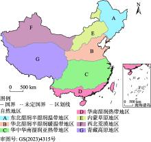
赵松乔. 中国综合自然地理区划的一个新方案[J]. 地理学报, 1983, 38(1): 1-10.
|
|
[Zhao Songqiao. A new scheme for comprehensive physical regionalization in China[J]. Acta Geographica Sinica, 1983, 38(1): 1-10.]
doi: 10.11821/xb198301001
|
| [16] |
Zhang G, Su X, Singh V P, et al. Appraising standardized moisture anomaly index (SZI) in drought projection across China under CMIP6 forcing scenarios[J]. Journal of Hydrology: Regional Studies, 2021, 37: 100898, doi: 10.1016/j.ejrh.2021.100898.
|
| [17] |
吴佳, 高学杰. 一套格点化的中国区域逐日观测资料及与其它资料的对比[J]. 地球物理学报, 2013, 56(4): 1102-1111.
|
|
[Wu Jia, Gao Xuejie. A gridded daily observation dataset over China region and comparison with the other datasets[J]. Chinese Journal of Geophysics, 2013, 56(4): 1102-1111.]
|
| [18] |
粟晓玲, 褚江东, 张特, 等. 西北地区地下水干旱时空演变趋势及对气象干旱的动态响应[J]. 水资源保护, 2022, 38(1): 34-42.
|
|
[Su Xiaoling, Chu Jiangdong, Zhang Te, et al. Spatio-temporal evolution trend of groundwater drought and its dynamic response to meteorological drought in northwest China[J]. Water Resources Protection, 2022, 38(1): 34-42.]
|
| [19] |
O’Neill B C, Tebaldi C, van Vuuren D P, et al. The scenario model intercomparison project (ScenarioMIP) for CMIP6[J]. Geoscientific Model Development, 2016, 9: 3461-3482.
doi: 10.5194/gmd-9-3461-2016
|
| [20] |
Danielson J J, Gesch D B. Global multi-resolution terrain elevation data 2010 (GMTED2010)[R]. Reston, VA, USA: U.S. Geological Survey, 2011.
|
| [21] |
姜彤, 苏布达, 王艳君, 等. 共享社会经济路径(SSPs)人口和经济格点化数据集[J]. 气候变化研究进展, 2022, 18(3): 381-383.
|
|
[Jiang Tong, Su Buda, Wang Yanjun, et al. Gridded datasets for population and economy under shared socioeconomic pathways for 2020—2100[J]. Climate Change Research, 2022, 18(3): 381-383.]
|
| [22] |
Huang J L, Qin D H, Jiang T, et al. Effect of fertility policy changes on the population structure and economy of China: From the perspective of the shared socioeconomic pathways[J]. Earth's Future, 2019, 7(3): 250-265.
doi: 10.1029/2018EF000964
|
| [23] |
Hurtt G C, Chini L, Sahajpal R, et al. Harmonization of global land use change and management for the period 850-2100 (LUH2) for CMIP6[J]. Geoscientific Model Development, 2020, 13(11): 5425-5464.
doi: 10.5194/gmd-13-5425-2020
|
| [24] |
Taylor K E. Summarizing multiple aspects of model performance in a single diagram[J]. Journal of Geophysical Research: Atmospheres, 2001, 106(D7): 7183-7192.
doi: 10.1029/2000JD900719
|
| [25] |
GB/T 20481-2017. 中华人民共和国国家标准: 气象干旱等级[S]. 北京: 中国标准出版社, 2017.
|
|
[GB/T 20481-2017. National Standard of the People's Republic of China: Grades of meteorological drought[S]. Beijing: Standards Press of China, 2017.]
|
| [26] |
王林, 陈文. 标准化降水蒸散指数在中国干旱监测的适用性分析[J]. 高原气象, 2014, 33(2): 423-431.
doi: 10.7522/j.issn.1000-0534.2013.00048
|
|
[Wang Lin, Chen Wen. Applicability analysis of standardized precipitation evapotranspiration index in drought monitoring in China[J]. Plateau Meteorology, 2014, 33(2): 423-431.]
doi: 10.7522/j.issn.1000-0534.2013.00048
|
| [27] |
Beguería S, Vicente-Serrano S M, Reig F, et al. Standardized precipitation evapotranspiration index (SPEI) revisited: Parameter fitting, evapotranspiration models, tools, datasets and drought monitoring[J]. International Journal of Climatology, 2014, 34(10): 3001-3023.
doi: 10.1002/joc.2014.34.issue-10
|
| [28] |
Ma Z, Sun P, Zhang Q, et al. The characteristics and evaluation of future droughts across China through the CMIP6 multi-model ensemble[J]. Remote Sensing, 2022, 14: 1097, doi: 10.3390/rs14051097.
|
| [29] |
费振宇, 孙宏巍, 金菊良, 等. 近50年中国气象干旱危险性的时空格局探讨[J]. 水电能源科学, 2014, 32(12): 5-10.
|
|
[Fei Zhenyu, Sun Hongwei, Jin Juliang, et al. Temporal and spatial patterns of meteorological drought hazard in China for recent 50 years[J]. Water Resources and Power, 2014, 32(12): 5-10.]
|
| [30] |
徐玉霞, 许小明, 方锋, 等. 县域尺度下的宝鸡市农业洪水灾害脆弱性评价及区划[J]. 干旱区地理, 2020, 43(3): 652-660.
|
|
[Xu Yuxia, Xu Xiaoming, Fang Feng, et al. Assessment and zoning of vulnerability of agricultural flood diaster in Baoji City based on county scale[J]. Arid Land Geography, 2020, 43(3): 652-660.]
|
| [31] |
康利刚, 曹生奎, 曹广超, 等. 青海湖流域地表温度时空变化特征研究[J]. 干旱区地理, 2023, 46(7): 1084-1097.
|
|
[Kang Ligang, Cao Shengkui, Cao Guangchao, et al. Spatiotemporal variation of land surface temperature in Qinghai Lake Basin[J]. Arid Land Geography, 2023, 46(7): 1084-1097.]
|
| [32] |
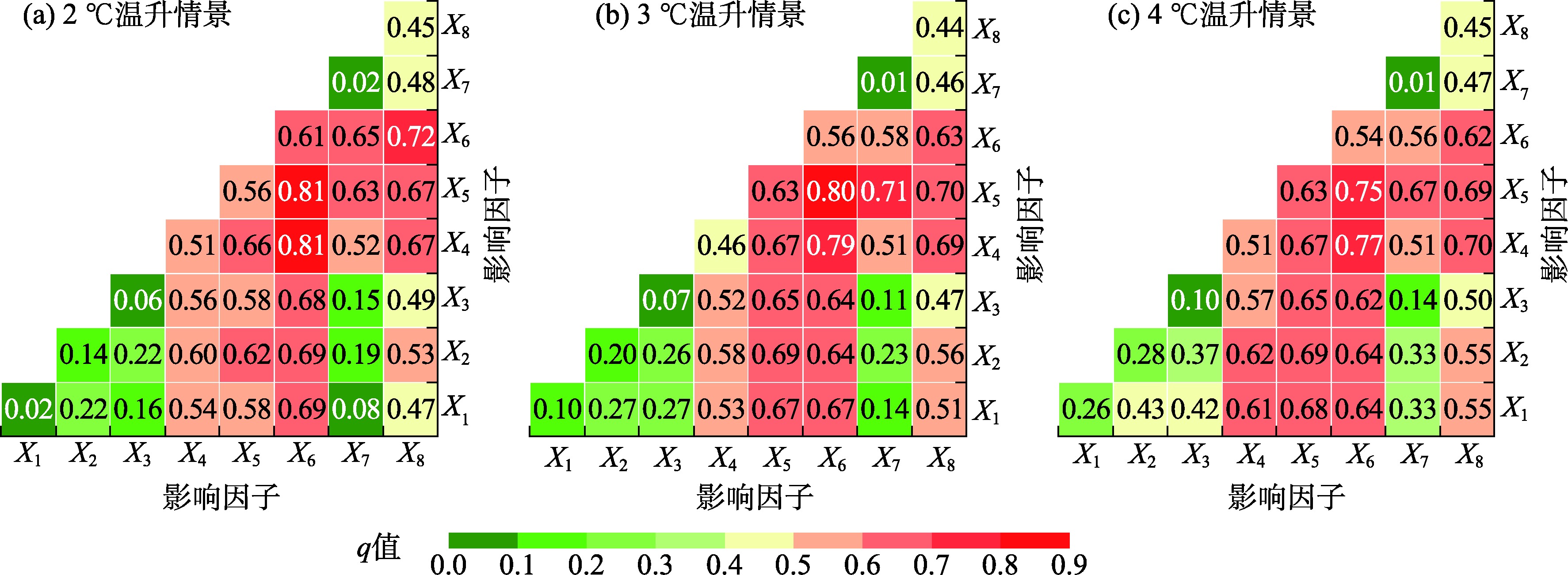
王劲峰, 徐成东. 地理探测器:原理与展望[J]. 地理学报, 2017, 72(1): 116-134.
doi: 10.11821/dlxb201701010
|
|
[Wang Jinfeng, Xu Chengdong. Geodetector: Principle and prospective[J]. Acta Geographica Sinica, 2017, 72(1): 116-134.]
doi: 10.11821/dlxb201701010
|
| [33] |
Song Y Z, Wang J F, Ge Y, et al. An optimal parameters-based geographical detector model enhances geographic characteristics of explanatory variables for spatial heterogeneity analysis: Cases with different types of spatial data[J]. GIScience & Remote Sensing, 2020, 57(5): 593-610.
|
| [34] |
卢冬燕, 朱秀芳, 刘婷婷, 等. 2 ℃温升情景下中国气象干旱特征变化[J]. 干旱区地理, 2023, 46(8): 1227-1237.
|
|
[Lu Dongyan, Zhu Xiufang, Liu Tingting, et al. Changes in meteorological drought characteristics in China under the 2 ℃ temperature rise scenario[J]. Arid Land Geography, 2023, 46(8): 1227-1237.]
|
| [35] |
尹晓东, 董思言, 韩振宇, 等. 未来50 a长江三角洲地区干旱和洪涝灾害风险预估[J]. 气象与环境学报, 2018, 34(5): 66-75.
|
|
[Yin Xiaodong, Dong Siyan, Han Zhenyu, et al. Projected risk of drought and flood at Yangtze River Delta for the next 50 years[J]. Journal of Meteorology and Environment, 2018, 34(5): 66-75.]
|
 ), 朱秀芳1,2,3(