干旱区地理 ›› 2022, Vol. 45 ›› Issue (5): 1547-1558.doi: 10.12118/j.issn.1000-6060.2022.018 cstr: 32274.14.ALG2022018
谢聪慧1,2( ),吴世新1(),林娟3,庄庆威4,张子慧1,2,侯冠宇1,2,罗格平1
收稿日期:2022-01-11
修回日期:2022-02-11
出版日期:2022-09-25
发布日期:2022-10-20
作者简介:谢聪慧(1997-),女,硕士研究生,主要从事遥感与地理信息系统应用研究. E-mail: 基金资助:
XIE Conghui1,2(),WU Shixin1(),LIN Juan3,ZHUANG Qingwei4,ZHANG Zihui1,2,HOU Guanyu1,2,LUO Geping1
Received:2022-01-11
Revised:2022-02-11
Published:2022-09-25
Online:2022-10-20
摘要:
盐渍化是构成绿洲农业低产的主要原因之一,也是农业开发和可持续发展的重要限制因素。为提高盐渍化耕地生产力,促进绿洲农业的可持续发展,以喀什噶尔绿洲耕地为研究对象,利用Landsat 8 OLI遥感影像数据提取遥感指数20个,利用土地利用数据计算研究区耕地开垦年限,用线性拟合的方法将用植被光合作用模型(VPM)模拟的植被净初级生产力(NPP)数据进行降尺度,将遥感指数同土壤采样及实测数据进行相关分析,得到优选的遥感特征变量,再用粒子群优化算法(PSO)优化的概率神经网络(PNN)模型进行盐渍化程度分类,得到研究区耕地盐渍化等级分布情况,后与研究区耕地开垦年限和NPP进行叠加分析。结果表明:(1) 选取增强型植被指数(EVI)、盐分指数2(SI2)、湿度指数(WI)、MSAVI-WI-SI特征空间(MWSI)、波段6(B6,2.11~2.29 μm)5个遥感参量通过PSO-PNN模型进行盐渍化程度反演准确率约为80%。(2) 耕地开垦年限越大的区域盐渍化程度越低。新开垦的耕地主要分布在研究区东部,而研究区西部大都为开垦年限在45 a以上的老绿洲农业区。(3) 耕地盐渍化严重降低了耕地农作物生产力。研究区耕地NPP较高的区域大都分布在西部,较低的区域大都分布在东部,与盐渍化程度等级分布大致相反。上述研究方法与结果可为后续使用遥感参量进行盐渍化反演的研究提供参考,对干旱半干旱区的盐渍化耕地改良具有一定的参考意义。
谢聪慧,吴世新,林娟,庄庆威,张子慧,侯冠宇,罗格平. 基于PSO-PNN模型的喀什噶尔绿洲耕地盐渍化分析[J]. 干旱区地理, 2022, 45(5): 1547-1558.
XIE Conghui,WU Shixin,LIN Juan,ZHUANG Qingwei,ZHANG Zihui,HOU Guanyu,LUO Geping. Analysis of cultivated land salinization in Kashgar Oasis based on PSO-PNN model[J]. Arid Land Geography, 2022, 45(5): 1547-1558.

图1
研究区采样点分布"

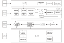
图2
技术路线 注:NPP为植被净初级生产力;K-T变换为缨帽变换;PNN为概率神经网络;PSO为粒子群优化算法。"

表1
遥感指数特征变量"
| 类别 | 名称 | 公式 |
|---|---|---|
| 植被指数 | 归一化植被指数(NDVI) | |
| 增强型植被指数(EVI) | | |
| 修改型土壤调节植被指数 (MSAVI) | | |
| 盐分指数 | 盐分指数(SI) | |
| 归一化盐分指数(NDSI) | | |
| 盐分指数2(SI2) | | |
| 盐分指数3(SI3) | | |
| K-T变换因子 | 湿度指数(WI) | |
| 绿度指数(GVI) | | |
| 下垫面反射因子 | 地表反照率(Albedo) | |
| | | |
| 多维特征空间 | MSAVI-WI特征空间(MWI) | |
| NDVI-SI特征空间(SDI) | | |
| MSAVI-WI-SI特征空间(MWSI) | | |
| 波段反射率因子 | 波段2~7(B2、B3、B4、B5、B6、B7) | |
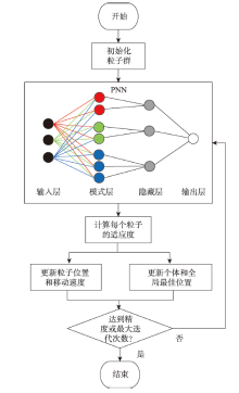
图3
PSO流程图"


图4
候选指标与总盐的相关性 注:B7为波段7;B6为波段6;B5为波段5;B4为波段4;B3为波段3;B2为波段2;MSAVI为修改型土壤调节植被指数;SDI为NDVI-SI特征空间;MWI为MSAVI-WI特征空间; I F e 2 O 3为 F e 2 O 3质量分数;Albedo为地表反射率;GVI为绿度指数;WI为湿度指数;SI3为盐分指数3;SI2为盐分指数2;NDSI为归一化盐分指数;SI为盐分指数;MWSI为MSAVI-WI-SI特征空间;EVI为增强型植被指数;NDVI为归一化植被指数。"

表2
样本分级"
| 盐渍化程度等级 | 总盐/mg·g-1 |
|---|---|
| 第一级 | 0.00~3.05 |
| 第二级 | 3.05~7.42 |
| 第三级 | 7.42~11.30 |
| 第四级 | 11.30~12.60 |
| 第五级 | 12.60~13.90 |
| 第六级 | 13.90~17.60 |
图5
喀什噶尔绿洲耕地盐渍化分级"
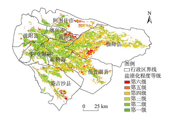
表3
喀什噶尔绿洲各市县耕地盐渍化等级面积占比"
| 市县 | 盐渍化等级占比/% | 总面积/km2 | |||||||
|---|---|---|---|---|---|---|---|---|---|
| 第一级 | 第二级 | 第三级 | 第一至第三级 | 第四级 | 第五级 | 第六级 | 第四至第六级 | ||
| 阿克陶县 | 25.01 | 0.14 | 46.38 | 71.53 | 21.41 | 1.67 | 5.39 | 28.47 | 463.77 |
| 疏附县 | 25.05 | 0.05 | 42.68 | 67.78 | 20.20 | 1.27 | 10.76 | 32.22 | 1030.86 |
| 喀什市 | 22.25 | 0.00 | 43.28 | 65.53 | 18.07 | 0.75 | 15.65 | 34.47 | 215.64 |
| 疏勒县 | 15.40 | 0.07 | 43.74 | 59.21 | 33.44 | 0.67 | 6.69 | 40.79 | 1292.31 |
| 英吉沙县 | 15.58 | 0.05 | 37.43 | 53.05 | 27.81 | 0.86 | 18.28 | 46.95 | 752.85 |
| 阿图什市 | 20.41 | 0.00 | 30.65 | 51.06 | 26.89 | 0.66 | 21.39 | 48.94 | 423.36 |
| 岳普湖县 | 10.92 | 0.11 | 33.13 | 44.16 | 43.42 | 0.42 | 12.00 | 55.84 | 985.23 |
| 伽师县 | 6.95 | 0.07 | 32.46 | 39.48 | 48.53 | 0.40 | 11.60 | 60.52 | 2162.34 |
| 总计 | 14.78 | 0.07 | 37.58 | 52.43 | 35.20 | 0.72 | 11.65 | 47.57 | 7326.36 |
表4
喀什噶尔绿洲耕地开垦年限和盐渍化的关系"
| 耕地开垦年限/a | 盐渍化等级占比/% | 总面积/km2 | |||||
|---|---|---|---|---|---|---|---|
| 第一级 | 第二级 | 第三级 | 第四级 | 第五级 | 第六级 | ||
| 0~10 | 1.27 | 0.08 | 13.24 | 57.28 | 1.09 | 27.03 | 2015.73 |
| 11~20 | 3.98 | 0.04 | 25.50 | 53.93 | 1.09 | 15.45 | 486.27 |
| 21~30 | 9.58 | 0.11 | 37.60 | 42.82 | 1.29 | 8.61 | 167.31 |
| 31~45 | 12.17 | 0.05 | 43.83 | 34.29 | 0.83 | 8.83 | 390.33 |
| >45 | 22.83 | 0.07 | 49.89 | 22.42 | 0.47 | 4.32 | 4266.72 |
| 总计 | 14.78 | 0.07 | 37.58 | 35.20 | 0.72 | 11.65 | 7326.36 |

图6
喀什噶尔绿洲耕地开垦年限"
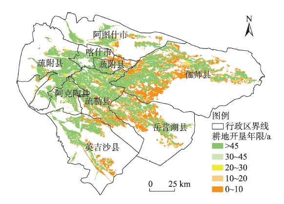
表5
喀什噶尔绿洲耕地不同盐渍化等级 面积及对应NPP"
| 盐渍化等级 | 面积/km2 | NPP/g·m-2·a-1 |
|---|---|---|
| 第一级 | 1063.80 | 719.33 |
| 第二级 | 4.86 | 630.39 |
| 第一至第二级 | 1068.66 | 718.93 |
| 第三级 | 2695.77 | 696.29 |
| 第四级 | 2515.14 | 651.98 |
| 第三至第四级 | 5210.91 | 674.90 |
| 第五级 | 50.13 | 636.22 |
| 第六级 | 808.47 | 639.25 |
| 第五至第六级 | 858.60 | 639.08 |
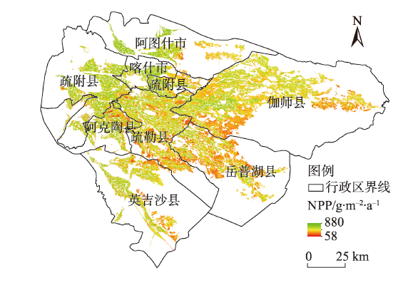
图7
喀什噶尔绿洲耕地植被NPP"
| [1] | Mahmoud A A, Shabbir A S, Yasser R O. Soil salinity mapping model developed using RS and GIS: A case study from Abu Dhabi, United Arab Emirates[J]. European Journal of Scientific Research, 2010, 26(3): 342-351. |
| [2] | 丁建丽, 姚远, 王飞. 基于三维光谱特征空间的干旱区土壤盐渍化遥感定量研究[J]. 土壤学报, 2013, 50(5): 853-861. |
| [Ding Jianli, Yao Yuan, Wang Fei. Quantitative remote sensing of soil salinization in arid regions based on three dimensional spectrum eigen spaces[J]. Acta Pedologica Sinica, 2013, 50(5): 853-861. ] | |
| [3] |
Peng J, Biswas A, Jiang Q S, et al. Estimating soil salinity from remote sensing and terrain data in southern Xinjiang Province, China[J]. Geoderma, 2018, 337: 1309-1319.
doi: 10.1016/j.geoderma.2018.08.006 |
| [4] | 谭军利, 康跃虎, 焦艳平, 等. 不同种植年限覆膜滴灌盐碱地土壤盐分离子分布特征[J]. 农业工程学报, 2008, 24(6): 59-63. |
| [Tan Junli, Kang Yuehu, Jiao Yanping, et al. Characteristics of soil salinity and salt ions distribution in salt-affected field under mulch-drip irrigation in different planting years[J]. Transactions of the CSAE, 2008, 24(6): 59-63. ] | |
| [5] | 刘圣锋, 高柏, 张海阳, 等. 塔里木盆地西部地下水水质评价及氟化物富集特征——以阿克陶县为例[J]. 干旱区地理, 2021, 44(5): 1261-1271. |
| [Liu Shengfeng, Gao Bai, Zhang Haiyang, et al. Evaluation of groundwater quality and fluoride enrichment characteristics in western Tarim Basin: A case study of Akto County[J]. Arid Land Geography, 2021, 44(5): 1261-1271. ] | |
| [6] | 梁萌, 米晓军, 李晨华, 等. 新疆准噶尔盆地未开垦盐碱土盐分与盐生植被多样性分析[J]. 干旱区地理, 2022, 45(1): 185-196. |
| [Liang Meng, Mi Xiaojun, Li Chenhua, et al. Salinity characteristics and halophytic vegetation diversity of uncultivated saline-alkali soil in Junggar Basin, Xinjiang[J]. Arid Land Geography, 2022, 45(1): 185-196. ] | |
| [7] |
苏里坦, 阿不都·沙拉木, 宋郁东. 膜下滴灌水量对土壤水盐运移及再分布的影响[J]. 干旱区研究, 2011, 28(1): 79-84.
doi: 10.3724/SP.J.1148.2011.00079 |
|
[Su Litan, Salamu Abdu, Song Yudong. Effects of drip irrigation volume on soil water-salt transfer and its redistribution[J]. Arid Zone Research, 2011, 28(1): 79-84. ]
doi: 10.3724/SP.J.1148.2011.00079 |
|
| [8] | 刘恒, 钟华平, 顾颖. 西北干旱内陆河区水资源利用与绿洲演变规律研究——以石羊河流域下游民勤盆地为例[J]. 水科学进展, 2001, 12(3): 378-384. |
| [Liu Heng, Zhong Huaping, Gu Ying. Water resources development and oasis evolution in inland river basin of arid zone of northwest China: A case study of Minqin Basin of Shiyang River[J]. Advances in Water Science, 2001, 12(3): 378-384. ] | |
| [9] | 虎胆·吐马尔白, 赵永成, 马合木江·艾合买提, 等. 北疆常年膜下滴灌棉田土壤盐分积累特征研究[J]. 灌溉排水学报, 2016, 35(1): 1-5. |
| [Tumalbai Hudan, Zhao Yongcheng, Aihemat Mahemujiang, et al. Study on characteristics of cotton field soil accumulation under perennial mulched drip irrigation in northern Xinjiang[J]. Journal of Irrigation and Drainage, 2016, 35(1): 1-5. ] | |
| [10] | 吴亚坤, 刘广明, 杨劲松, 等. 基于反距离权重插值的土壤盐分三维分布解析方法[J]. 农业工程学报, 2013, 29(3): 100-106. |
| [Wu Yakun, Liu Guangming, Yang Jinsong, et al. Interpreting method of region soil salinity 3D distribution based on inverse distance weighting[J]. Transactions of the China Society of Agricultural Engineering, 2013, 29(3): 100-106. ] | |
| [11] | 董积忠. 喀什地区耕地土壤盐渍化现状及改良对策[J]. 新疆农业科技, 2013(5): 34-35. |
| [Dong Jizhong. Current situation and improvement countermeasures of soil salinization in cultivated land in Kashgar[J]. Xinjiang Agricultural Science and Technology, 2013(5): 34-35. ] | |
| [12] | 阿不都拉·阿不力孜. 于田绿洲土壤盐分分布特征及其生态效应[D]. 乌鲁木齐: 新疆大学, 2016. |
| [Abuliz Abdullah. Characteristics of soil salinity distribution and its ecological effects in Yutian Oasis[D]. Urumqi: Xinjiang University, 2016. ] | |
| [13] | 曹雷, 丁建丽, 于海洋. 渭-库绿洲多尺度景观格局与盐度关系[J]. 农业工程学报, 2016, 32(3): 101-110. |
| [Cao Lei, Ding Jianli, Yu Haiyang. Relationship between multi-scale landscape pattern and salinity in Weigan and Kuqa rivers delta oasis[J]. Transactions of the China Society of Agricultural Engineering, 2016, 32(3): 101-110. ] | |
| [14] | 牛增懿, 丁建丽, 李艳华, 等. 基于高分一号影像的土壤盐渍化信息提取方法[J]. 干旱区地理, 2016, 39(1): 171-181. |
| [Niu Zengyi, Ding Jianli, Li Yanhua, et al. Soil salinization information extraction method based on GF-1 image[J]. Arid Land Geography, 2016, 39(1): 171-181. ] | |
| [15] | 梁静, 丁建丽, 王敬哲, 等. 基于反射光谱与 Landsat 8 OLI 多光谱数据的艾比湖湿地土壤盐分估算[J]. 土壤学报, 2019, 56(2): 72-82. |
| [Liang Jing, Ding Jianli, Wang Jingzhe, et al. Quantitative estimation and mapping of soil salinity in the Ebinur Lake wetland based on Vis-NIR reflectance and Landsat 8 OLI data[J]. Acta Pedologica Sinica, 2019, 56(2): 72-82. ] | |
| [16] | 郭鹏, 李华, 陈红艳, 等. 基于光谱指数优选的土壤盐分定量光谱估测[J]. 水土保持通报, 2018, 38(3): 193-199. |
| [Guo Peng, Li Hua, Chen Hongyan, et al. Quantitative spectral estimation of soil salinity based on optimum spectral indices[J]. Bulletin of Soil and Water Conservation, 2018, 38(3): 193-199. ] | |
| [17] | 阿尔达克·克里木. 艾比湖流域盐渍化土壤的多光谱和高光谱遥感反演与生态效应研究[D]. 乌鲁木齐: 新疆大学, 2016. |
| [Kerimu Aldak. Multispectral and hyperspectral remote sensing inversion and ecological effects of salinized soils in the Lake Aibi Basin[D]. Urumqi: Xinjiang University, 2016. ] | |
| [18] | 依力亚斯江·努尔麦麦提. 土壤盐渍化微波遥感监测及其风险定量估计研究[D]. 乌鲁木齐: 新疆大学, 2016. |
| [Nuermaiti Yiliyasijiang. Research on microwave remote sensing monitoring of soil salinization and its risk quantitative estimation[D]. Urumqi: Xinjiang University, 2016. ] | |
| [19] | 丁建丽, 张喆, 李鑫, 等. 中亚土库曼斯坦绿洲土壤盐渍化动态演变评估[J]. 干旱区地理, 2013, 36(4): 571-578. |
| [Ding Jianli, Zhang Zhe, Li Xin, et al. Assessment of dynamic evolution on soil salinization of an oasis in Turkmenistan of Central Asia[J]. Arid Land Geography, 2013, 36(4): 571-578. ] | |
| [20] | 丁建丽, 瞿娟, 孙永猛, 等. 基于MSAVI-WI特征空间的新疆渭干河-库车河流域绿洲土壤盐渍化研究[J]. 地理研究, 2013, 32(2): 223-232. |
| [Ding Jianli, Qu Juan, Sun Yongmeng, et al. The retrieval model of soil salinization information in arid region based on MSAVI-WI feature space: A case study of the delta oasis in Weigan-Kuqa watershed[J]. Geographical Research, 2013, 32(2): 223-232. ] | |
| [21] | Allbed A, Kumar L, Aldakheel Y Y. Assessing soil salinity using soil salinity and vegetation indices derived from IKONOS high-spatial resolution imageries: Applications in a date palm dominated region[J]. Geoderma, 2014, 230-231: 1-8. |
| [22] |
Weng Y L, Gong P, Zhu Z L. A spectral index for estimating soil salinity in the Yellow River delta region of China using EO-1 Hyperion data[J]. Pedosphere, 2010, 20(3): 378-388.
doi: 10.1016/S1002-0160(10)60027-6 |
| [23] |
Dehni A, Lounis M. Remote sensing techniques for salt affected soil mapping: Application to the Oran region of Algeria[J]. Procedia Engineering, 2012, 33: 188-198.
doi: 10.1016/j.proeng.2012.01.1193 |
| [24] |
Ketata M, Gueddari M, Bouhlila R. Hydrodynamic and salinity evolution of groundwaters during artificial recharge within semi-arid coastal aquifers: A case study of El Khairat aquifer system in Enfidha (Tunisian Sahel)[J]. Journal of African Earth Sciences, 2014, 97: 224-229.
doi: 10.1016/j.jafrearsci.2014.05.002 |
| [25] |
Wei G F, Li Y, Zhang Z T, et al. Estimation of soil salt content by combining UAV-borne multispectral sensor and machine learning algorithms[J]. PeerJ, 2020, 8(2): e9087, doi: 10.7717/peerj.9087.
doi: 10.7717/peerj.9087 |
| [26] |
Fu C B, Gan S, Yuan X P, et al. Determination of soil salt content using a probability neural network model based on particle swarm optimization in areas affected and non-affected by human activities[J]. Remote Sensing, 2018, 10(9): 1387, doi: 10.3390/rs10091387.
doi: 10.3390/rs10091387 |
| [27] | 葛翔宇, 丁建丽, 王敬哲, 等. 基于竞争适应重加权采样算法耦合机器学习的土壤含水量估算[J]. 光学学报, 2018, 38(10): 393-400. |
| [Ge Xiangyu, Ding Jianli, Wang Jingzhe, et al. Estimation of soil moisture content based on competitive adaptive reweighted sampling algorithm coupled with machine learning[J]. Acta Optica Sinica, 2018, 38(10): 393-400. ] | |
| [28] | 蔡亮红. 基于变量优选和ELM算法的土壤含水量估测研究[D]. 乌鲁木齐: 新疆大学, 2018. |
| [Cai Lianghong. Prediction for soil water content based on variable preferred and extreme learning machine algorithm[D]. Urumqi: Xinjiang University, 2018. ] | |
| [29] |
Specht D F. Probabilistic neural networks[J]. Neural Networks, 1990, 3(1): 109-118.
doi: 10.1016/0893-6080(90)90049-Q |
| [30] |
De Oliveira M A, Inman D. Performance analysis of simplified Fuzzy ARTMAP and Probabilistic Neural Networks for identifying structural damage growth[J]. Applied Soft Computing, 2017, 52: 53-63.
doi: 10.1016/j.asoc.2016.12.020 |
| [31] |
Sankari Z, Adeli H. Probabilistic neural networks for diagnosis of Alzheimer’s disease using conventional and wavelet coherence[J]. Journal of Neuroscience Methods, 2011, 197(1): 165-170.
doi: 10.1016/j.jneumeth.2011.01.027 pmid: 21310177 |
| [32] |
Tian A H, Fu C B, Yau H T, et al. A new methodology of soil salinization degree classification by probability neural network model based on centroid of fractional Lorenz chaos self-synchronization error dynamics[J]. IEEE Transactions on Geoscience and Remote Sensing, 2020, 58(2): 799-810.
doi: 10.1109/TGRS.2019.2940592 |
| [33] | 朱宏, 周宏飞, 陈小兵, 等. 新疆喀什地区的地下水资源特征分析[J]. 干旱区研究, 2005, 22(2): 153-155. |
| [Zhu Hong, Zhou Hongfei, Chen Xiaobing, et al. Analysis on the characteristics of groundwater resources in Kashgar Prefecture, Xinjiang[J]. Arid Zone Research, 2005, 22(2): 153-155. ] | |
| [34] | 毛炜峄, 孙本国, 王铁, 等. 近50年来喀什噶尔河流域气温、降水及径流的变化趋势[J]. 干旱区研究, 2006, 23(4): 531-538. |
| [Mao Weiyi, Sun Benguo, Wang Tie, et al. Change trends of temperature, precipitation and runoff volume in the Kaxgar River Basin since recent 50 years[J]. Arid Zone Research, 2006, 23(4): 531-538. ] | |
| [35] |
Griggs D J, Noguer M. Climate change 2001: The scientific basis. Contribution of working group I to the third assessment report of the intergovernmental panel on climate change[J]. Weather, 2002, 57(8): 267-269.
doi: 10.1256/004316502320517344 |
| [36] |
Jiang H L, Xu X, Guan M X, et al. Determining the contributions of climate change and human activities to vegetation dynamics in agro-pastural transitional zone of northern China from 2000 to 2015[J]. Science of the Total Environment, 2020, 718: 134871, doi: 10.1016/j.scitotenv.2019.134871.
doi: 10.1016/j.scitotenv.2019.134871 |
| [37] |
Xie C H, Wu S X, Zhuang Q W, et al. Where anthropogenic activity occurs, anthropogenic activity dominates vegetation net primary productivity change[J]. Remote Sensing, 2022, 14: 1092, doi: 10.3390/rs14051092.
doi: 10.3390/rs14051092 |
| [38] | Ding J L, Yu D L. Monitoring and evaluating spatial variability of soil salinity in dry and wet seasons in the Werigan-Kuqa Oasis, China, using remote sensing and electromagnetic induction instruments[J]. Geoderma, 2014, 235-236: 316-322. |
| [39] | Gu F X, Yu C, Zhang Y D, et al. Spatial and temporal dynamics of soil moisture and salinity in typical plant communities of Sangonghe Basin[J]. Proceedings of SPIE-The International Society for Optical Engineering, 2003, 4890(1): 471-479. |
| [40] |
Wang H S, Jia G S. Satellite-based monitoring of decadal soil salinization and climate effects in a semi-arid region of China[J]. Advances in Atmospheric Sciences, 2012, 29(5): 1089-1099.
doi: 10.1007/s00376-012-1150-8 |
| [41] |
Ali Baig M H, Zhang L F, Shuai T, et al. Derivation of a tasselled cap transformation based on Landsat 8 at-satellite reflectance[J]. Remote Sensing Letters, 2014, 5(4-6): 423-431.
doi: 10.1080/2150704X.2014.915434 |
| [42] |
Guo B, Yang F, Fan Y W, et al. Dynamic monitoring of soil salinization in Yellow River Delta utilizing MSAVI-SI feature space models with Landsat images[J]. Environmental Earth Sciences, 2019, 78(10): 308, doi: 10.1007/s12665-019-8319-8.
doi: 10.1007/s12665-019-8319-8 |
| [43] |
Ma Z Q, Shi Z, Zhou Y, et al. A spatial data mining algorithm for downscaling TMPA 3B43 V7 data over the Qinghai-Tibet Plateau with the effects of systematic anomalies removed[J]. Remote Sensing of Environment, 2017, 200: 378-395.
doi: 10.1016/j.rse.2017.08.023 |
| [44] |
Said N, Henning B, Joachim H, et al. Modeling and mapping of soil salinity with reflectance spectroscopy and landsat data using two quantitative methods (PLSR and MARS)[J]. Remote Sensing, 2014, 6(11): 10813-10834.
doi: 10.3390/rs61110813 |
| [45] | Wang F, Ding J L, Wu M C. Remote sensing monitoring models of soil salinization based on NDVI-SI feature space[J]. Transactions of the Chinese Society of Agricultural Engineering, 2010, 26(8): 168-173. |
| [46] |
罗亮, 闫慧敏, 牛忠恩. 农田生产力监测中3种多源遥感数据融合方法的对比分析[J]. 地球信息科学学报, 2018, 20(2): 268-279.
doi: 10.12082/dqxxkx.2018.170068 |
|
[Luo Liang, Yan Huimin, Niu Zhong’en. Comparative analysis on three multi-source remote sensing data fusion models in monitoring farmland productivity[J]. Journal of Geo-information Science, 2018, 20(2): 268-279. ]
doi: 10.12082/dqxxkx.2018.170068 |
|
| [47] |
Lobell D B, Hicke J A, Asner G P, et al. Satellite estimates of productivity and light use efficiency in united states agriculture, 1982-98[J]. Global Change Biology, 2002, 8(8): 722-735.
doi: 10.1046/j.1365-2486.2002.00503.x |
| [48] |
Xue B, Zhang M J, Browne W N. Particle swarm optimization for feature selection in classification: A multi-objective approach[J]. IEEE Transactions on Cybernetics, 2013, 43(6): 1656-1671.
doi: 10.1109/TSMCB.2012.2227469 pmid: 24273143 |
| [49] |
Kuila P, Jana P K. Energy efficient clustering and routing algorithms for wireless sensor networks: Particle swarm optimization approach[J]. Engineering Applications of Artificial Intelligence, 2014, 33: 127-140.
doi: 10.1016/j.engappai.2014.04.009 |
| [50] |
Ishaque K, Salam Z, Amjad M, et al. An improved particle swarm optimization (PSO)-based MPPT for PV with reduced steady-state oscillation[J]. IEEE Transactions on Power Electronics, 2012, 27(8): 3627-3638.
doi: 10.1109/TPEL.2012.2185713 |
| [51] |
Chatterjee A, Siarry P. Nonlinear inertia weight variation for dynamic adaptation in particle swarm optimization[J]. Computers & Operations Research, 2006, 33(3): 859-871.
doi: 10.1016/j.cor.2004.08.012 |
| [52] |
朱文会, 毛飞, 徐影, 等. 三江源区植被指数对气候变化的响应及预测分析[J]. 高原气象, 2019, 38(4): 693-704.
doi: 10.7522/j.issn.1000-0534.2018.00105 |
|
[Zhu Wenhui, Mao Fei, Xu Ying, et al. Analysis on response of vegetation index to climate change and its prediction in the three-rivers-source region[J]. Plateau Meteorology, 2019, 38(4): 693-704. ]
doi: 10.7522/j.issn.1000-0534.2018.00105 |
|
| [53] | 杨劲松, 姚荣江, 王相平, 等. 防止土壤盐渍化, 提高土壤生产力[J]. 科学, 2021, 73(6): 30-34, 2, 4. |
| [Yang Jinsong, Yao Rongjiang, Wang Xiangping, et al. Prevent soil salinization and improve soil productivity[J]. Science, 2021, 73(6): 30-34, 2, 4. ] |
| [1] | 潘雪, 关宇淇, 潘占东, 刘杰, 蔡立群, 董博, 杜健. 干旱区耕地质量等级时空变化及其评价——以西宁市为例[J]. 干旱区地理, 2023, 46(5): 793-803. |
| [2] | 卢卓瑜,崔建新,张晓虹,李鹏. 清至民国毛乌素沙地佟哈拉克泊复原及演变研究[J]. 干旱区地理, 2021, 44(4): 1083-1092. |
|
||