干旱区地理 ›› 2026, Vol. 49 ›› Issue (10): 2145-2157.doi: 10.12118/j.issn.1000-6060.2026.042 cstr: 32274.14.ALG2026042
左超燕1( ), 贾科利1(), 叶静雨1, 李浩宇1, 张俊华2
收稿日期:2026-01-21
修回日期:2026-02-12
出版日期:2026-10-25
发布日期:2026-10-26
通讯作者:
贾科利(1975-),男,博士,教授,主要从事土壤盐渍化定量遥感反演、土地利用与生态环境效应等方面的研究. E-mail: jiakl@nxu.edu.cn作者简介:左超燕(2001-),女,硕士研究生,主要从事土壤盐渍化定量遥感反演等方面的研究. E-mail: z16063702@163.com论文构思:贾科利、左超燕;数据管理:左超燕、李浩宇;规范分析:叶静雨、李浩宇;获取资助:贾科利、张俊华;调查研究:左超燕、叶静雨;方法设计:左超燕、贾科利;项目管理:左超燕、贾科利;提供资源:贾科利、张俊华;软件编程:左超燕、叶静雨;监督指导:贾科利;验证复核:左超燕;可视化:左超燕;初稿撰写:左超燕、贾科利;修订编辑:左超燕。
基金资助:
ZUO Chaoyan1(), JIA Keli1(), YE Jingyu1, LI Haoyu1, ZHANG Junhua2
Received:2026-01-21
Revised:2026-02-12
Published:2026-10-25
Online:2026-10-26
摘要:
高效精确获取土壤盐分和有机质信息是有效治理和监测土壤盐渍化的基础。以新疆维吾尔自治区喀什地区伽师县试验农田为研究对象,以地面高光谱反射率数据和实验室测定值为数据源,对原始高光谱反射率进行步长为0.25的0.00~2.00阶微分变换,选取与土壤电导率(EC)、土壤有机质(SOM)相关性最高的阶数为最佳变换阶数,使用连续投影算法筛选敏感波段,基于敏感波段构建光谱指数,并使用递归特征消除方法筛选光谱指数。建立随机森林模型、支持向量回归模型、轻量级梯度提升机模型和堆叠集成学习(Stacking)模型,对EC和SOM进行反演。结果表明:(1) 对原始高光谱反射率进行微分变换,显著提升了光谱反射率数据与EC和SOM的相关性,最优分数阶均出现在0.75阶,较原始光谱最大相关性分别最高提升了0.041、0.091。(2) Stacking模型在EC和SOM反演中均表现最优,其决定系数分别达到0.708和0.680,误差最小、精度最高,较最优单模型分别提高约8.4%、5.4%,可作为试验区EC与SOM遥感反演的稳健方案。(3) EC与SOM在空间分布上呈一定负相关,高盐分区域有机质含量较低,二者空间格局可能受多因素共同控制。
左超燕, 贾科利, 叶静雨, 李浩宇, 张俊华. 基于地面高光谱与堆叠集成学习的农田土壤盐分与有机质信息反演[J]. 干旱区地理, 2026, 49(10): 2145-2157.
ZUO Chaoyan, JIA Keli, YE Jingyu, LI Haoyu, ZHANG Junhua. Inversion of soil salinity and organic matter information in farmland using ground-based hyperspectral data and stacked ensemble learning[J]. Arid Land Geography, 2026, 49(10): 2145-2157.
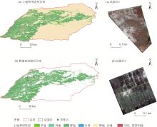
图1
研究区示意图"
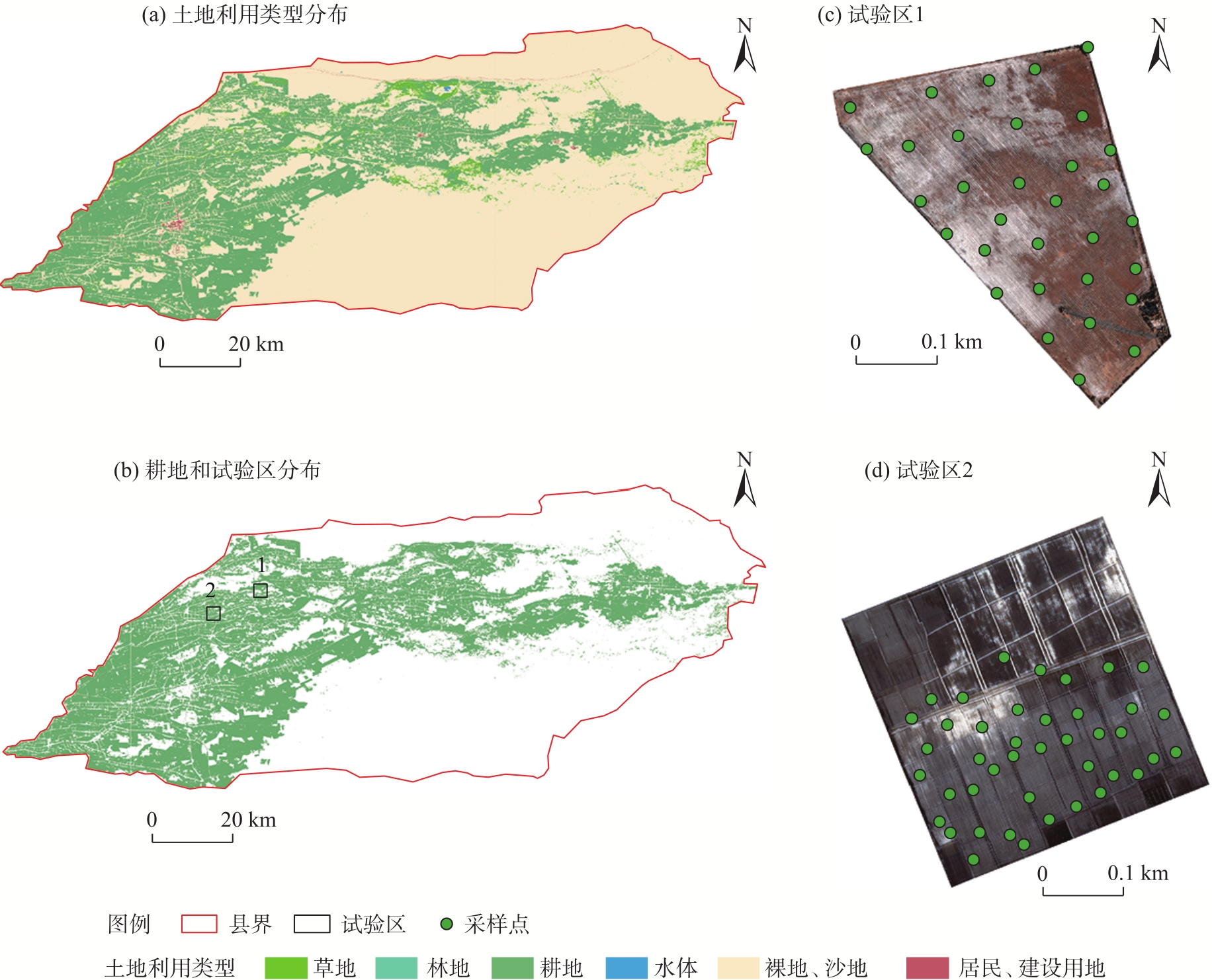
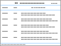
表1
各指标样本等级统计"
| 指标 | 等级划分 | 含量 | 样本数 | 平均值 | 最大值 | 最小值 | 标准差 | 变异系数/% |
|---|---|---|---|---|---|---|---|---|
| EC/dS·m-1 | 非盐化 | <2 | 5 | 1.52 | 1.82 | 0.82 | 0.43 | 28.00 |
| 轻度盐化 | [2, 4) | 25 | 3.09 | 3.98 | 2.10 | 0.55 | 17.80 | |
| 中度盐化 | [4, 8) | 32 | 5.68 | 7.95 | 4.02 | 1.25 | 22.00 | |
| 重度盐化 | [8, 16) | 10 | 9.84 | 11.39 | 8.10 | 1.29 | 13.10 | |
| 盐土 | ≥16 | 2 | 16.76 | 17.20 | 16.32 | 0.62 | 0.37 | |
| SOM/g·kg-1 | 极缺乏 | <6 | 4 | 5.36 | 5.89 | 4.75 | 0.50 | 9.34 |
| 很缺乏 | [6, 10) | 35 | 8.15 | 9.89 | 6.07 | 0.99 | 12.18 | |
| 缺乏 | [10, 20) | 35 | 10.20 | 18.60 | 12.72 | 1.82 | 14.28 | |
| 中等 | [20, 30) | 0 | - | - | - | - | - | |
| 丰富 | [30, 40) | 0 | - | - | - | - | - | |
| 很丰富 | ≥40 | 0 | - | - | - | - | - |
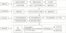
图2
研究技术路线 注:EC为土壤电导率;SOM为土壤有机质;SPA为逐次投影算法;RFE为递归特征消除法;RI为比值指数;DI为差值指数;NDI为归一化差异指数;RF为随机森林;SVR为支持向量回归;LightGBM为轻量级梯度提升机;Stacking为堆叠集成学习;Ridge为岭回归。下同。"
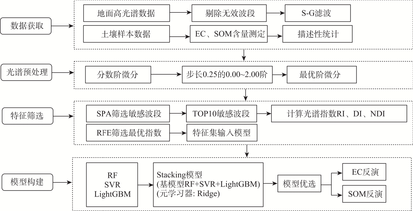
表2
光谱指数计算公式"
| 光谱指数 | 计算公式 |
|---|---|
| RI[ | |
| DI[ | DIi,j=Ri-Rj |
| NDI[ |
表3
贝叶斯优化机器学习超参数"
| 模型 | 参数 | 超参数范围 | 核心参数 |
|---|---|---|---|
| RF | n_estimators | [50, 100] | 75.00 |
| max_depth | [2, 6] | 4.00 | |
| LightGBM | n_estimators | [80, 100] | 84.00 |
| max_depth | [2, 4] | 4.00 | |
| num_leaves | [8, 16] | 8.00 | |
| SVR | C | [0.1, 100.0] | 1.00 |
| gamma | [0.001, 1.000] | 0.17 | |
| Stacking | alpha(Ridge元学习器) | [0.01, 100.00] | 1.00 |
| CV(基学习器交叉验证折数) | [3, 10] | 5.00 |
图3
不同土壤盐分与有机质含量原始光谱曲线变化特征"
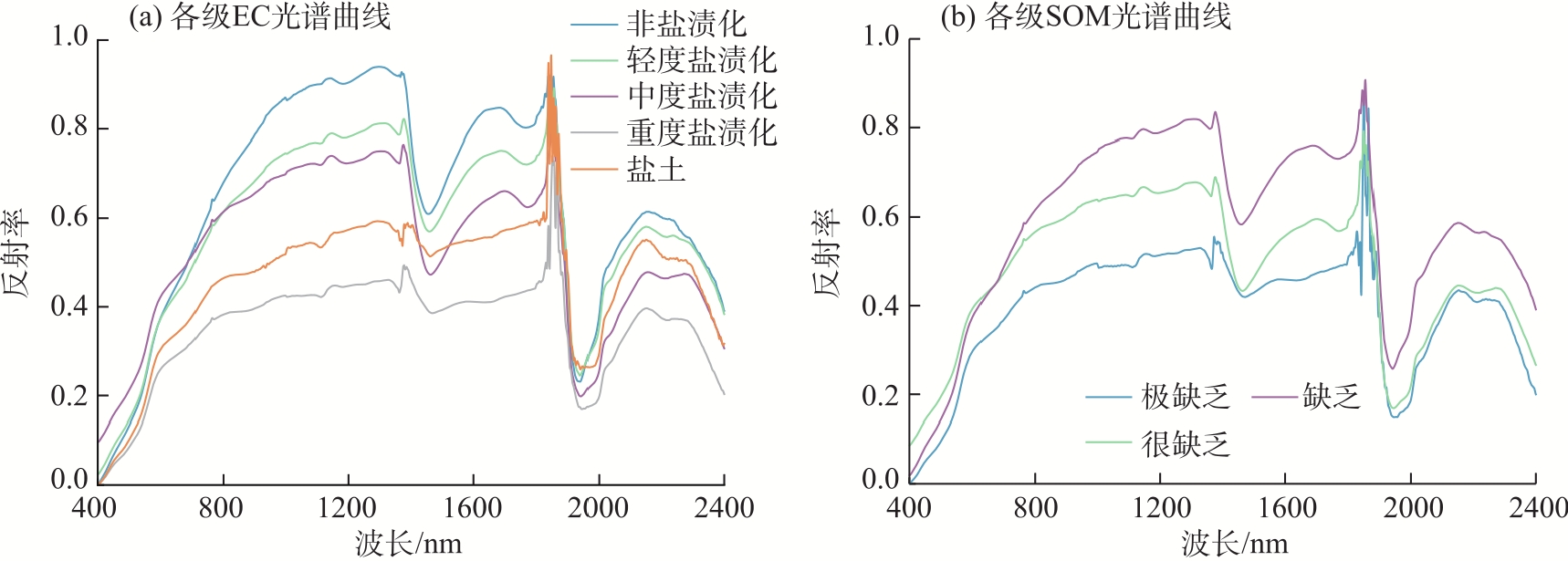
表4
分数阶微分与土壤指标相关性分析"
| 阶数 | EC | SOM | |||||
|---|---|---|---|---|---|---|---|
| 最大相关系数绝对值 | 平均相关系数绝对值 | 显著波段数 | 最大相关系数绝对值 | 平均相关系数绝对值 | 显著波段数 | ||
| 0.00 | 0.564 | 0.368 | 1619 | 0.608 | 0.384 | 1572 | |
| 0.25 | 0.558 | 0.332 | 1486 | 0.620 | 0.355 | 1533 | |
| 0.50 | 0.564 | 0.306 | 1208 | 0.607 | 0.320 | 1307 | |
| 0.75 | 0.605 | 0.285 | 1092 | 0.699 | 0.287 | 1154 | |
| 1.00 | 0.596 | 0.240 | 960 | 0.668 | 0.239 | 887 | |
| 1.25 | 0.573 | 0.182 | 656 | 0.633 | 0.199 | 765 | |
| 1.50 | 0.485 | 0.135 | 362 | 0.578 | 0.156 | 501 | |
| 1.75 | 0.453 | 0.121 | 258 | 0.527 | 0.143 | 405 | |
| 2.00 | 0.470 | 0.119 | 245 | 0.541 | 0.141 | 377 | |
表5
RFE筛选光谱指数"
| 土壤指标 | 光谱指数 | 波段1/nm | 波段2/nm |
|---|---|---|---|
| EC | RI | 2279 | 1810 |
| 1289 | 1810 | ||
| DI | 2279 | 1289 | |
| 1810 | 2160 | ||
| 1878 | 1834 | ||
| 1878 | 1837 | ||
| 1289 | 1886 | ||
| 1886 | 1834 | ||
| 1886 | 2160 | ||
| NDI | 1289 | 1810 | |
| SOM | RI | 2279 | 1834 |
| 1810 | 1878 | ||
| 1837 | 2160 | ||
| 1810 | 1791 | ||
| DI | 2279 | 1289 | |
| 1289 | 2160 | ||
| 1810 | 1791 | ||
| 1289 | 1791 | ||
| NDI | 1810 | 1381 | |
| 1834 | 2160 |
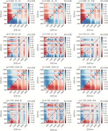
图4
0.00阶、最优阶次光谱指数与EC、SOM的二维相关系数"

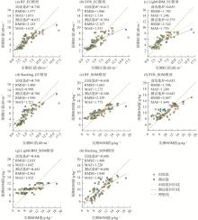
图5
模型训练集和测试集性能 注:R2为决定系数;RMSE为均方根误差;MAE为平均绝对误差。"

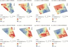
图6
基于Stacking模型的EC、SOM实测值、预测值插值图"

| [1] |
尼格拉·塔什甫拉提, 马莹轩, 阿不都外力·热合曼, 等. 基于哨兵数据与特征空间模型的新疆渭库绿洲土壤盐渍化遥感反演[J]. 干旱区地理, 2026, 49(2): 287-300.
doi: 10.12118/j.issn.1000-6060.2025.064 |
|
[Tashipulati Nigela, Ma Yingxuan, Reheman Abudouwaili, et al. Remote sensing inversion of soil salinization in the Weiku Oasis of Xinjiang using Sentinel data and a feature space model[J]. Arid Land Geography, 2026, 49(2): 287-300. ]
doi: 10.12118/j.issn.1000-6060.2025.064 |
|
| [2] | 张俊华, 尚天浩, 陈睿华, 等. 基于光谱FOD与优化指数的银川平原土壤有机质含量反演[J]. 农业机械学报, 2022, 53(11): 379-387. |
| [Zhang Junhua, Shang Tianhao, Chen Ruihua, et al. Inversion of soil organic matter content in Yinchuan Plain using field spectral fractional-order derivatives combined with spectral optimization index[J]. Transactions of the Chinese Society for Agricultural Machinery, 2022, 53(11): 379-387. ] | |
| [3] | 王晨晨, 孙向阳, 李素艳, 等. 不同利用方式土地的土壤盐碱化特征差异[J]. 土壤通报, 2023, 54(5): 1167-1175. |
| [Wang Chenchen, Sun Xiangyang, Li Suyan, et al. Soil salinization characteristics in different land use soils[J]. Chinese Journal of Soil Science, 2023, 54(5): 1167-1175. ] | |
| [4] | 邓凯, 丁建丽, 杨爱霞, 等. 基于电磁感应技术的土壤剖面盐分空间分布建模研究[J]. 生态学报, 2016, 36(20): 6387-6396. |
| [Deng Kai, Ding Jianli, Yang Aixia, et al. Modeling of the spatial distribution of soil profile salinity based on the electromagnetic induction technique[J]. Acta Ecologica Sinica, 2016, 36(20): 6387-6396. ] | |
| [5] | 马纬, 武志明, 温鑫伟, 等. 遥感多光谱成像在解析土壤成分方面研究进展[J]. 农业工程, 2022, 12(11): 30-36. |
| [Ma Wei, Wu Zhiming, Wen Xinwei, et al. Research progress of remote sensing multispectral imaging in analyzing soil components[J]. Agricultural Engineering, 2022, 12(11): 30-36. ] | |
| [6] | 王俊栋, 孙志刚, 杨婷, 等. CYGNSS土壤盐分反演方法研究: 以黄河三角洲为例[J]. 遥感学报, 2023, 27(2): 351-362. |
|
[Wang Jundong, Sun Zhigang, Yang Ting, et al. A remote sensing method for retrieving soil salinity based on CYGNSS: Taking the Yellow River Delta as an example[J]. National Remote Sensing Bulletin, 2023, 27(2): 351-362. ]
doi: 10.11834/jrs.20210466 |
|
| [7] | Francos N, Ogen Y, Ben Dor E. Spectral assessment of organic matter with different composition using reflectance spectroscopy[J]. Remote Sensing, 2021, 13(8): 1549, doi: 10.3390/rs13081549. |
| [8] |
周世勋, 尹娟, 杨莹攀, 等. 土壤质地对灌区土壤盐分高光谱反演精度影响研究[J]. 节水灌溉, 2024(6): 1-10.
doi: 10.12396/jsgg.2023454 |
|
[Zhou Shixun, Yin Juan, Yang Yingpan, et al. Effect of soil texture on the accuracy of hyperspectral inversion of soil salinity in irrigated area[J]. Water Saving Irrigation, 2024(6): 1-10. ]
doi: 10.12396/jsgg.2023454 |
|
| [9] | 李鑫星, 梁步稳, 白雪冰, 等. 光谱技术在土壤水分含量检测中的研究进展[J]. 光谱学与光谱分析, 2020, 40(12): 3705-3710. |
| [Li Xinxing, Liang Buwen, Bai Xuebing, et al. Research progress of spectroscopy in the detection of soil moisture content[J]. Spectroscopy and Spectral Analysis, 2020, 40(12): 3705-3710. ] | |
| [10] |
程俊恺, 冯秀丽, 陈立波, 等. 基于无人机高光谱数据的耕地土壤盐分反演模型优选[J]. 应用生态学报, 2024, 35(11): 3085-3094.
doi: 10.13287/j.1001-9332.202411.012 |
|
[Cheng Junkai, Feng Xiuli, Chen Libo, et al. Optimal inversion model for cultivated land soil salinity based on UAV hyperspectral data[J]. Chinese Journal of Applied Ecology, 2024, 35(11): 3085-3094. ]
doi: 10.13287/j.1001-9332.202411.012 |
|
| [11] | 丁启东, 王怡婧, 张俊华, 等. 基于高光谱信息的宁夏土壤有机质含量估算[J]. 生态学杂志, 2024, 43(8): 2531-2538. |
|
[Ding Qidong, Wang Yijing, Zhang Junhua, et al. Estimation of soil organic matter content in Ningxia based on hyperspectral information[J]. Chinese Journal of Ecology, 2024, 43(8): 2531-2538. ]
doi: 10.13292/j.1000-4890.202408.040 |
|
| [12] |
Qian Z, Ding J L, Guo X Y, et al. Estimation of soil organic matter in the Ogan-Kuqa River Oasis, northwest China, based on visible and near-infrared spectroscopy and machine learning[J]. Journal of Arid Land, 2023, 15(2): 191-204.
doi: 10.1007/s40333-023-0094-4 |
| [13] | Chlouveraki E, Katsenios N, Efthimiadou A, et al. Estimation of soil properties using hyperspectral imaging and machine learning[J]. Smart Agricultural Technology, 2025, 10: 100790, doi: 10.1016/j.atech.2025.100790. |
| [14] | Jiang X Q, Luo S J, Ye Q, et al. Hyperspectral estimates of soil moisture content incorporating harmonic indicators and machine learning[J]. Agriculture, 2022, 12(8): 1188, doi: 10.3390/agriculture12081188. |
| [15] |
王怡婧, 陈睿华, 张俊华, 等. 基于分数阶微分技术的土壤水盐信息高光谱反演[J]. 应用生态学报, 2023, 34(5): 1384-1394.
doi: 10.13287/j.1001-9332.202305.025 |
|
[Wang Yijing, Chen Ruihua, Zhang Junhua, et al. Hyperspectral inversion of soil water and salt information based on fractional order derivative technology[J]. Chinese Journal of Applied Ecology, 2023, 34(5): 1384-1394. ]
doi: 10.13287/j.1001-9332.202305.025 |
|
| [16] | 苗瑞雪, 贺银海, 刘孝阳, 等. 利用机器学习模型预测土壤重金属空间分布的研究进展[J]. 环境科学研究, 2025, 38(5): 1087-1097. |
| [Miao Ruixue, He Yinhai, Liu Xiaoyang, et al. Predicting the spatial distribution of heavy metals in soil using machine learning models: A review[J]. Research of Environmental Sciences, 2025, 38(5): 1087-1097. ] | |
| [17] | Xuan F, Su W, Chen Z, et al. Performance of stacking machine learning and volume model for improving corn above ground biomass prediction[J]. Plant Phenomics, 2025, 7(3): 100068, doi: 10.1016/j.plaphe.2025.100068. |
| [18] | 齐江涛, 程盼婷, 高芳芳, 等. 农田土壤理化参数快速获取技术研究进展与展望[J]. 智慧农业(中英文), 2024, 6(3): 17-33. |
|
[Qi Jiangtao, Cheng Panting, Gao Fangfang, et al. Research advances and prospects on rapid acquisition technology of farmland soil physical and chemical parameters[J]. Smart Agriculture, 2024, 6(3): 17-33. ]
doi: 10.12133/j.smartag.SA202404003 |
|
| [19] | 杨金财, 银征, 吴昊天, 等. 盐碱区地形改造中土壤EC值变化趋势--以江苏射阳日月岛“U”环生态廊道项目为例[J]. 现代园艺, 2021, 44(1): 41-43. |
| [Yang Jincai, Yin Zheng, Wu Haotian, et al. Trends of soil electrical conductivity (EC) changes during terrain modification in saline-alkali areas: A case study of the “U”-ring ecological corridor project on Riyue Island, Sheyang, Jiangsu Province[J]. Modern Horticulture, 2021, 44(1): 41-43. ] | |
| [20] | 罗杰敏. 土壤中有机质含量的测定方法和影响因素研究[J]. 山西化工, 2025, 45(6): 97-99. |
| [Luo Jiemin. Study on the determination method and influencing factors of organic matter content in soil[J]. Shanxi Chemical Industry, 2025, 45(6): 97-99. ] | |
| [21] | 王遵亲, 祝寿泉, 俞仁培, 等. 中国盐渍土[M]. 北京: 科学出版社, 1993: 333-334. |
| [Wang Zunqin, Zhu Shouquan, Yu Renpei, et al. Salt-affected soils in China[M]. Beijing: Science Press, 1993: 333-334. ] | |
| [22] | 张子鹏, 丁建丽, 王敬哲, 等. 利用三维光谱指数定量估算土壤有机质含量: 以新疆艾比湖流域为例[J]. 光谱学与光谱分析, 2020, 40(5): 1514-1522. |
| [Zhang Zipeng, Ding Jianli, Wang Jingzhe, et al. Quantitative estimation of soil organic matter content using three-dimensional spectral index: A case study of the Ebinur Lake Basin in Xinjiang[J]. Spectroscopy and Spectral Analysis, 2020, 40(5): 1514-1522. ] | |
| [23] | 国佳欣, 朱青, 赵小敏, 等. 不同土地利用类型下土壤有机碳含量的高光谱反演[J]. 应用生态学报, 2020, 31(3): 863-871. |
|
[Guo Jiaxin, Zhu Qing, Zhao Xiaomin, et al. Hyper-spectral inversion of soil organic carbon content under different land use types[J]. Chinese Journal of Applied Ecology, 2020, 31(3): 863-871. ]
doi: 10.13287/j.1001-9332.202003.014 |
|
| [24] |
黄华雨, 丁启东, 张俊华, 等. 基于Sentinel-2和可解释机器学习的河套平原农田土壤盐分和pH反演[J]. 应用生态学报, 2025, 36(8): 2407-2419.
doi: 10.13287/j.1001-9332.202508.012 |
|
[Huang Huayu, Ding Qidong, Zhang Junhua, et al. Inversion of soil salinity and pH in farmland of the Hetao Plain based on Sentinel-2 and explainable machine learning[J]. Chinese Journal of Applied Ecology, 2025, 36(8): 2407-2419. ]
doi: 10.13287/j.1001-9332.202508.012 |
|
| [25] | 周健, 季晓菲, 闫宏昌. 基于无人机遥感与高光谱技术的农业病虫害精准监测与防治策略研究[J]. 智慧农业导刊, 2025, 5(15): 33-36. |
| [Zhou Jian, Ji Xiaofei, Yan Hongchang. Precise monitoring and control strategies for agricultural pests and diseases based on UAV remote sensing and hyperspectral technologies[J]. Smart Agriculture Guide, 2025, 5(15): 33-36. ] | |
| [26] | 丁松滔, 张霞, 尚坤, 等. 基于分数阶微分的土壤重金属高光谱遥感图像反演[J]. 遥感学报, 2023, 27(9): 2191-2205. |
|
[Ding Songtao, Zhang Xia, Shang Kun, et al. Estimating soil heavy metal from hyperspectral remote sensing images base on fractional order derivative[J]. National Remote Sensing Bulletin, 2023, 27(9): 2191-2205. ]
doi: 10.11834/jrs.20232513 |
|
| [27] | 吴梦红, 窦森, 林楠, 等. 联合FOD-sCARS的土壤有机质高光谱机器学习估测模型[J]. 光谱学与光谱分析, 2025, 45(1): 204-212. |
| [Wu Menghong, Dou Sen, Lin Nan, et al. Hyperspectral estimation of soil organic matter based on FOD-sCARS and machine learning algorithm[J]. Spectroscopy and Spectral Analysis, 2025, 45(1): 204-212. ] | |
| [28] | Deng M H, Zhang C, Tang M, et al. Stacking ensemble learning coupled with multi-source remote sensing data: Enhancing soil salinity inversion accuracy in barley-cultivated salinized soils[J]. Agricultural Water Management, 2025, 322: 109959, doi: 10.1016/j.agwat.2025.109959. |
| [29] | Wu M H, Dou S, Lin N, et al. Estimation and mapping of soil organic matter content using a stacking ensemble learning model based on hyperspectral images[J]. Remote Sensing, 2023, 15(19): 4713, doi: 10.3390/rs15194713. |
| [30] | Dong H L, Tian F. Soil salinity inversion based on a Stacking integrated learning algorithm[J]. Agriculture, 2024, 14(10): 1777, doi: 10.3390/agriculture14101777. |
| [31] |
黄华雨, 丁启东, 张俊华, 等. 基于地面高光谱的宁夏银北地区农田不同土层盐碱化信息反演[J]. 应用生态学报, 2024, 35(11): 3073-3084.
doi: 10.13287/j.1001-9332.202411.017 |
|
[Huang Huayu, Ding Qidong, Zhang Junhua, et al. Ground-based hyperspectral inversion of salinization and alkalinization of different soil layers in farmland in Yinbei area, Ningxia, China[J]. Chinese Journal of Applied Ecology, 2024, 35(11): 3073-3084. ]
doi: 10.13287/j.1001-9332.202411.017 |
|
| [32] |
刘瑞亮, 贾科利, 李小雨, 等. 组合光学和微波遥感的耕地土壤含盐量反演[J]. 干旱区地理, 2024, 47(3): 433-444.
doi: 10.12118/j.issn.1000-6060.2023.375 |
|
[Liu Ruiliang, Jia Keli, Li Xiaoyu, et al. Inversion of soil salt content by combining optical and microwave remote sensing in cultivated land[J]. Arid Land Geography, 2024, 47(3): 433-444. ]
doi: 10.12118/j.issn.1000-6060.2023.375 |
|
| [33] | Lin N, Ma X H, Sui Y Y, et al. Soil salinity estimation based on satellite hyperspectral and synthetic aperture radar remote sensing image fusion[J]. Agricultural Water Management, 2026, 323: 110076, doi: 10.1016/j.agwat.2025.110076. |
| [34] |
Qiao X X, Wang C, Feng M C, et al. Hyperspectral estimation of soil organic matter based on different spectral preprocessing techniques[J]. Spectroscopy Letters, 2017, 50(3): 156-163.
doi: 10.1080/00387010.2017.1297958 |
| [35] |
Zhang W W, Wang C, Xue R, et al. Effects of salinity on the soil microbial community and soil fertility[J]. Journal of Integrative Agriculture, 2019, 18(6): 1360-1368.
doi: 10.1016/S2095-3119(18)62077-5 |
| [36] |
傅新, 张浩然, 王元波, 等. 黄河三角洲盐渍区土壤盐分三维空间分异及其影响因素[J]. 地球信息科学学报, 2025, 27(9): 2135-2150.
doi: 10.12082/dqxxkx.2024.240020 |
| [Fu Xin, Zhang Haoran, Wang Yuanbo, et al. Three-dimensional spatial differentiation of soil salinity and its influencing factors in the saline soil areas of the Yellow River Delta[J]. Journal of Geo-Information Science, 2025, 27(9): 2135-2150. ] |
| [1] | 杨明新, 宁晓春, 杨刘生, 张亚飞, 石明明, 康彦斌, 黄青东智, 王守兴, 周华坤. 基于可解释机器学习模型的高寒草地土壤盐渍化反演[J]. 干旱区地理, 2026, 49(3): 549-558. |
| [2] | 李雷, 薛新帅, 刘家民. 基于机器学习模型的海绵城市建设政策对黄河流域鸟类生物多样性的影响[J]. 干旱区地理, 2026, 49(10): 2205-2214. |
| [3] | 郭佳丽, 马勇刚, 潘恒, 李娜, 孙长宁, 孙倩, 周文昶, 党瑀璇. 艾比湖春夏季土壤盐渍化卫星监测对比分析[J]. 干旱区地理, 2025, 48(12): 2143-2157. |
| [4] | 高瑞翔, 罗格平, 张文强, 谢明娟, 王渊刚. 长短期记忆网络在生态系统碳通量反演中的优势与应用[J]. 干旱区地理, 2025, 48(12): 2210-2219. |
| [5] | 辛悦, 苏立娟, 郑旭程, 李慧, 衣娜娜, 靳雨晨. 内蒙古冰雹特征及基于机器学习的冰雹识别方法研究[J]. 干旱区地理, 2025, 48(1): 11-19. |
| [6] | 刘瑞亮, 贾科利, 李小雨, 陈睿华, 王怡婧, 张俊华. 组合光学和微波遥感的耕地土壤含盐量反演[J]. 干旱区地理, 2024, 47(3): 433-444. |
| [7] | 崔锦涛, 买买提·沙吾提. 基于特征波段选择和机器学习的陆地棉叶片水分估算[J]. 干旱区地理, 2023, 46(11): 1836-1847. |
| [8] | 魏慧敏, 贾科利, 张旭, 张俊华. 基于机器学习和多光谱遥感的银川平原土壤盐分预测[J]. 干旱区地理, 2023, 46(1): 103-114. |
| [9] | 赵爽,丁建丽,韩礼敬,黄帅,葛翔宇. 新疆典型盐渍土微波介电特性响应分析与建模[J]. 干旱区地理, 2022, 45(5): 1534-1546. |
| [10] | 刘旭辉,白云岗,柴仲平,张江辉,丁邦新,江柱. 基于多光谱遥感的典型绿洲棉田春季土壤盐分反演及验证[J]. 干旱区地理, 2022, 45(4): 1165-1175. |
| [11] | 尹瀚民,古丽·加帕尔,于涛,Jeanine UMUHOZA,李旭. 哈萨克斯坦北部小麦遥感估产方法研究[J]. 干旱区地理, 2022, 45(2): 488-498. |
| [12] | 胡贵贵,杨粉莉,杨联安,郑玉蓉,王辉,陈卫军,李亚丽. 基于主成分和机器学习的土壤有机质含量空间预测建模[J]. 干旱区地理, 2021, 44(4): 1114-1124. |
| [13] | 李慧融. 基于反射率和亮度温度的锡林郭勒积雪深度估算[J]. 干旱区地理, 2020, 43(6): 1567-1572. |
| [14] | 柳菲, 陈沛源, 于海超, 马金珠. 民勤绿洲不同土地利用类型下土壤水盐的空间分布特征分析 [J]. 干旱区地理, 2020, 43(2): 406-414. |
| [15] | 包青岭, 丁建丽, 王敬哲, 蔡亮红. 基于随机森林算法的土壤有机质含量高光谱检测 [J]. 干旱区地理, 2019, 42(6): 1404-1414. |
|
||