| [1] |
秦大河. 冰冻圈科学辞典[M]. 北京: 气象出版社, 2014.
|
|
[ Qin Dahe. Glossary of cryospheric science[M]. Beijing: China Meteorological Press, 2014. ]
|
| [2] |
Zhang T G, Wang W C, Shen Z H, et al. Increasing frequency and destructiveness of glacier-related slope failures under global warming[J]. Science Bulletin, 2024, 69: 30-33.
|
| [3] |
王宁练, 姚檀栋, 徐柏青, 等. 全球变暖背景下青藏高原及周边地区冰川变化的时空格局与趋势及影响[J]. 中国科学院院刊, 2019, 34(11): 1220-1232.
|
|
[ Wang Ninglian, Yao Tandong, Xu Baiqing, et al. Spatiotemporal pattern, trend, and influence of glacier change in Tibetan Plateau and surroundings under global warming[J]. Bulletin of Chinese Academy of Sciences, 2019, 34(11): 1220-1232. ]
|
| [4] |
杨雪雯, 王宁练, 梁倩, 等. 近60 a天山北坡冰川变化研究[J]. 干旱区地理, 2023, 46(7): 1073-1083.
|
|
[ Yang Xuewen, Wang Ninglian, Liang Qian, et al. Glacier changes on the north slope of Tianshan Mountains in recent 60 years[J]. Arid Land Geography, 2023, 46(7): 1073-1083. ]
|
| [5] |
邬光剑, 姚檀栋, 王伟财, 等. 青藏高原及周边地区的冰川灾害[J]. 中国科学院院刊, 2019, 34(11): 1285-1292.
|
|
[ Wu Guangjian, Yao Tandong, Wang Weicai, et al. Glacial hazards on Tibetan Plateau and surrounding alpines[J]. Bulletin of Chinese Academy of Sciences, 2019, 34(11): 1285-1292. ]
|
| [6] |
许娇, 陈坤铭, 杨书菲, 等. “一带一路”交通基础设施建设的国际经贸效应[J]. 亚太经济, 2016, 3: 3-11.
|
|
[ Xu Jiao, Chen Kunming, Yang Shufei, et al. The impact of economic corridor transportation infrastructure under “the Belt and Road Initiative” based on GTAP model[J]. Asia-pacific Economic Review, 2016, 3: 3-11. ]
|
| [7] |
陈亚宁, 李稚, 方功焕. 中亚天山地区关键水文要素变化与水循环研究进展[J]. 干旱区地理, 2022, 45(1): 1-8.
|
|
[ Chen Yaning, Li Zhi, Fang Gonghuan. Changes of key hydrological elements and research progress of water cycle in the Tianshan Mountains, Central Asia[J]. Arid Land Geography, 2022, 45(1): 1-8. ]
|
| [8] |
吴立新, 李佳, 苗则朗, 等. 冰川流域孕灾环境及灾害的天空地协同智能监测模式与方向[J]. 测绘学报, 2021, 50(8): 1109-1121.
|
|
[ Wu Lixin, Li Jia, Miao Zelang, et al. Pattern and directions of spaceborne-airborne-ground collaborated intelligent monitoring on the geo-hazards developing environment and disasters in glacial basin[J]. Acta Geodaetica et Cartographica Sinica, 2021, 50(8): 1109-1121. ]
|
| [9] |
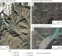
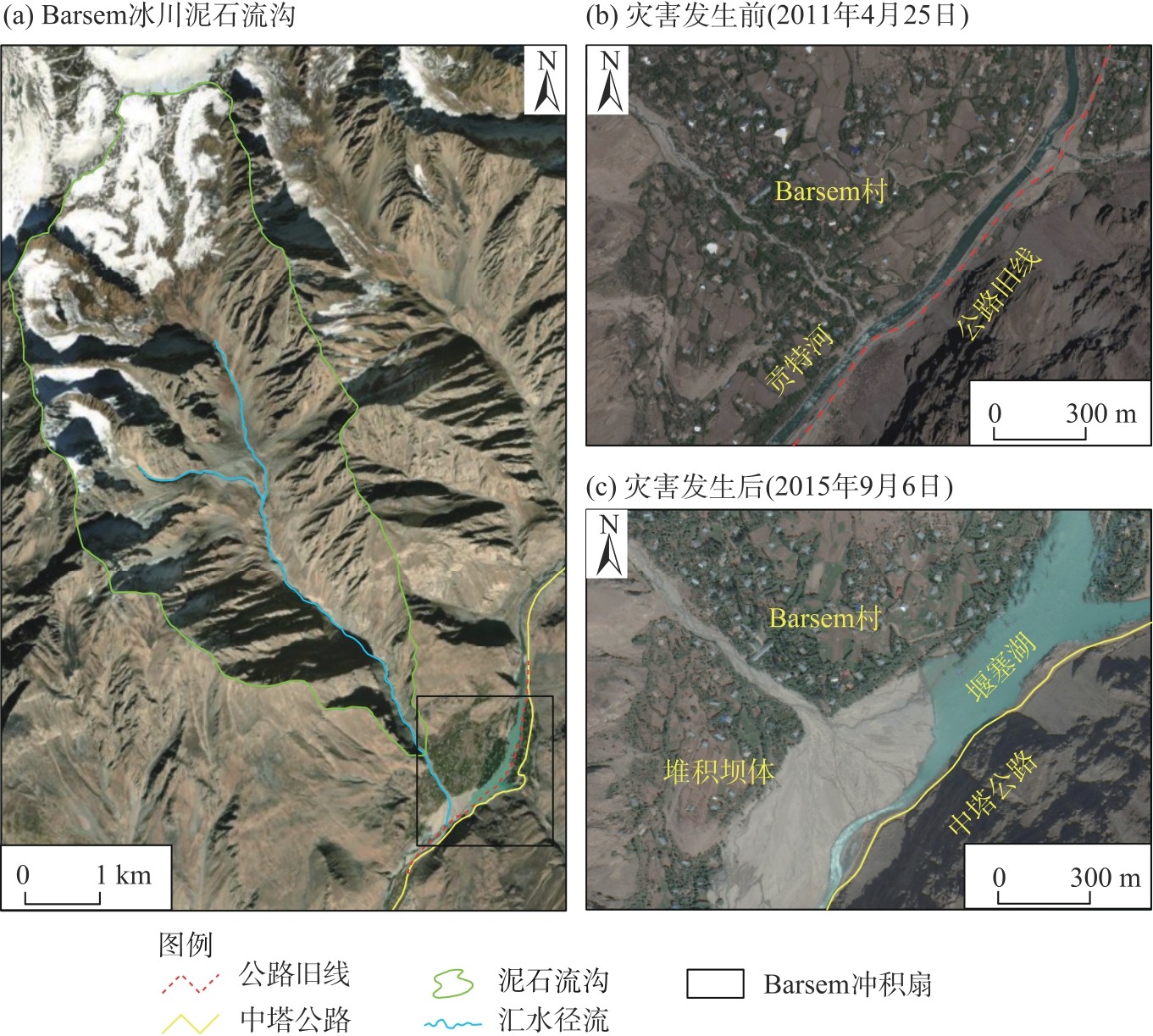
Zafar A, Uchimura T. The July 2015 debris flow in Barsem, western Pamir (GBAO) Tajikistan: Description and causes[J]. E3S Web of Conferences, 2023, 415: 03003, doi: 10.1051/e3sconf/202341503003.
|
| [10] |
朱颖彦, 李超月, 杨志全, 等. 中巴喀喇昆仑公路冰湖溃决灾害[J]. 山地学报, 2021, 39(4): 524-538.
|
|
[ Zhu Yingyan, Li Chaoyue, Yang Zhiquan, et al. Glacier lake outburst flood (GLOF) along China-Pakistan International Karakoram highway[J]. Mountain Research, 2021, 39(4): 524-538. ]
|
| [11] |
朱颖彦, 潘军宇, 李朝月, 等. 中巴喀喇昆仑公路冰川泥石流[J]. 山地学报, 2022, 40(1): 71-83.
|
|
[ Zhu Yingyan, Pan Junyu, Li Chaoyue, et al. Glacier debris flow along China-Pakistan International Karakoram highway (KKH)[J]. Mountain Research, 2022, 40(1): 71-83. ]
|
| [12] |
朱颖彦, 杨志全, 廖丽萍, 等. 中巴喀喇昆仑公路冰川地貌地质灾害[J]. 灾害学, 2014, 29(3): 81-90.
|
|
[ Zhu Yingyan, Yang Zhiquan, Liao Liping, et al. Glacialized geomorphologcial geohazard along China-Pakistan International Karakoram highway[J]. Journal of Catastrophology, 2014, 29(3): 81-90. ]
|
| [13] |
钟妍, 刘巧, 廖海军, 等. 中喜马拉雅山中-尼通道沿线冰川/冰湖变化及其相关灾害初步调查[J]. 山地学报, 2020, 38(2): 314-327.
|
|
[ Zhong Yan, Liu Qiao, Liao Haijun, et al. Glaciers and glacial lakes status and their related geo-hazards along three main China-Nepal corridors[J]. Mountain Research, 2020, 38(2): 314-327. ]
|
| [14] |
余国安, 鲁建莹, 李志威, 等. 气候变化影响下藏东南帕隆藏布流域高山区泥石流的地貌效应[J]. 地理学报, 2022, 77(3): 619-634.
|
|
[ Yu Guoan, Lu Jianying, Li Zhiwei, et al. Geomorphic effects of debris flows in high mountain areas of the Parlung Zangbo Basin, southeast Tibet under the influence of climate change[J]. Acta Geographica Sinica, 2022, 77(3): 619-634. ]
|
| [15] |
李志杰, 王宁练, 常佳雯. 巴托拉等冰川的新近变化及对中巴公路的影响[J]. 干旱区研究, 2022, 39(6): 1986-1995.
|
|
[ Li Zhijie, Wang Ninglian, Chang Jiawen, et al. Recent variations of the Batura, Pasu, and Ghulkin glaciers and their potential impact on the Karakoram highway[J]. Arid Zone Research, 2022, 39(6): 1986-1995. ]
|
| [16] |
Xie F N, Liu S Y, Gao Y P, et al. Interdecadal glacier inventories in the Karakoram since the 1990s[J]. Earth System Science Data, 2023, 15(2): 847-867.
|
| [17] |
江利明, 柳林, 汪汉胜. 基于ZY-3和SRTM DEM数据的青藏高原山地冰川物质平衡数据产品(2000—2018)[DB/OL]. [2023-11-02]. https://www.doi.org/10.11878/db.202311.011644.
|
|
[ Jiang Liming, Liu Lin, Wang Hansheng. Tibetan Plateau mountain glacier mass balance dataset based on ZY-3 DEMs (2000—2018)[DB/OL]. [ 2023-11-02]. https://www.doi.org/10.11878/db.202311.011644. ]
|
| [18] |
Wang X, Guo X Y, Yang C D, et al. Glacial lake inventory of high-mountain Asia in 1990 and 2018 derived from Landsat images[J]. Earth System Science Data, 2020, 12(3): 2169-2182.
|
| [19] |
温婷婷, 郭英香, 董少睿, 等. 1979—2017 年CRU、ERA5、CMFD 格点降水数据在青藏高原适用性评估[J]. 干旱区研究, 2022, 39(3): 684-697.
|
|
[ Wen Tingting, Guo Yingxiang, Dong Shaorui, et al. Assessment of CRU, ERA5, CMFD grid precipitation data for the Tibetan Plateau from 1979 to 2017[J]. Arid Zone Research, 2022, 39(3): 684-697. ]
|
| [20] |
Li Z J, Wang N L, Chen A A, et al. Slight change of glaciers in the Pamir over the period 2000—2017[J]. Arctic, Antarctic, and Alpine Research, 2022, 54(1): 13-24.
|
| [21] |
王小丽, 周凌翔, 王秀东, 等. 1990—2020年波曲流域冰川冰湖时空变化及其对气候变化的响应[J]. 干旱区地理, 2024, 47(5): 810-819.
|
|
[ Wang Xiaoli, Zhou Lingxiang, Wang Xiudong, et al. Temporal and spatial changes of glaciers and glacier lakes and its response to climate change in Poiqu Basin during 1990—2020[J]. Arid Land Geography, 2024, 47(5): 810-819. ]
|
| [22] |
李志杰. 全球变暖背景下帕米尔-喀喇昆仑-西昆仑地区冰川异常变化特征研究[D]. 西安: 西北大学, 2023.
|
|
[ Li Zhijie. Anomalous glacier change in the Pamir-Karakoram-west Kunlun under global warming[D]. Xi’an: Northwest University, 2023. ]
|
| [23] |
蔡兴冉, 李忠勤, 张慧, 等. 中国天山冰川变化脆弱性研究[J]. 地理学报, 2021, 76(9): 2253-2268.
|
|
[ Cai Xingran, Li Zhongqin, Zhang Hui, et al. Vulnerability of glacier change in Chinese Tianshan Mountains[J]. Acta Geographica Sinica, 2021, 76(9): 2253-2268. ]
|
| [24] |
秦大河. 冰冻圈科学概论[M]. 北京: 科学出版社, 2017.
|
|
[ Qin Dahe. Introduction to cryospheric science[M]. Beijing: Science Press, 2017. ]
|
| [25] |
戴玉萍, 王璞玉, 张正勇, 等. 中国阿尔泰山冰川变化脆弱性及适应能力影响因素分析[J]. 冰川冻土, 2024, 46(1): 1-14.
|
|
[ Dai Yuping, Wang Puyu, Zhang Zhengyong, et al. Analysis of glacier change vulnerability and influencing factors of adaptability in the Chinese Altai Mountains[J]. Journal of Glaciology and Geocryology, 2024, 46(1): 1-14. ]
|
| [26] |
Mirzo S, Nikolai I, Stefanos X, et al. Natural hazards in Tajikistan[R]. Dushanbe: Organization for Security and Co-operation in Europe (OSCE) Program Office in Dushanbe, 2016.
|
| [27] |
Yilmaz K, Dincer A E, Kalpakci V, et al. Debris flow modelling and hazard assessment for a glacier area: A case study in Barsem, Tajikistan[J]. Natural Hazards, 2023, 115: 2577-2601.
|
| [28] |
Su B, Xiao C D, Chen D L, et al. Mismatch between the population and meltwater changes creates opportunities and risks for global glacier-fed basins[J]. Science Bulletin, 2022, 67: 9-12.
|
| [29] |
董翰林, 王文婷, 谢云, 等. 新疆气候干湿变化特征及其影响因素[J]. 干旱区研究, 2023, 40(12): 1875-1884.
|
|
[ Dong Hanlin, Wang Wenting, Xie Yun, et al. Climate dry-wet conditions, changes, and their driving factors in Xinjiang[J]. Arid Zone Research, 2023, 40(12): 1875-1884. ]
|
| [30] |
刘巧, 聂勇, 王欣, 等. 中巴经济走廊沿线上游冰川冰湖相关灾害(事件)数据集[J]. 中国科学数据, 2021, 6(1): 00145, doi: 10.11922/csdata.2020.0099.zh.
|
|
[ Liu Qiao, Nie Yong, Wang Xin, et al. An inventory dataset of glacier and glacial lake related hazards (events) along the China-Pakistan Economic Corridor[J]. Chinese Science Data, 2021, 6(1): 00145, doi: 10.11922/csdata.2020.0099.zh. ]
|
| [31] |
陈满, 陈亚宁, 方功焕, 等. 昆仑山北坡冰川湖变化及其溃决风险评估[J]. 干旱区地理, 2024, 47(10): 1628-1639.
|
|
[ Chen Man, Chen Yaning, Fang Gonghuan, et al. Changes in glacial lakes on the northern slope of Kunlun Mountains and assessment of their outburst risks[J]. Arid Land Geography, 2024, 47(10): 1628-1639. ]
|
 ), 王宁练3,4,5(