干旱区地理 ›› 2025, Vol. 48 ›› Issue (2): 271-282.doi: 10.12118/j.issn.1000-6060.2024.286 cstr: 32274.14.ALG2024286
刘伟1( ), 凌红波2(), 公延明2, 陈伏龙1, 单钱娟2
收稿日期:2024-05-08
修回日期:2024-06-02
出版日期:2025-02-25
发布日期:2025-02-25
通讯作者:
凌红波(1983-),男,研究员,主要从事生态水文过程研究. E-mail: linghongbo0929@163.com作者简介:刘伟(1999-),男,在读研究生,主要从事生态水文过程研究. E-mail: liuwei999122@163.com
基金资助:
LIU Wei1(), LING Hongbo2(), GONG Yanming2, CHEN Fulong1, SHAN Qianjuan2
Received:2024-05-08
Revised:2024-06-02
Published:2025-02-25
Online:2025-02-25
摘要:
塔里木河干流是我国西北干旱区的重要生态屏障之一,作为生态输水的直接受益区,研究其生态环境质量变化对于理解生态输水工程的效果和评估流域生态环境质量具有重要意义。基于1998—2022年的Landsat遥感影像,耦合绿度(NDVI)、湿度(WET)、干度(NDBSI)、热度(LST)、盐度(SI_T)5个指标构建改进型遥感生态指数(RSEIS),运用Mann-Kendall检验、Theil-Sen Median趋势分析、Hurst指数、变异系数分析塔里木河干流生态环境质量发展趋势及稳定性,通过地理探测器分析了各驱动因素对RSEIS的影响。结果表明:(1) 1998—2022年塔里木河干流生态环境质量整体呈波动上升趋势,平均增幅为0.023·(10a)-1,多年平均RSEIS呈现出北高南低、西高东低的空间分布特征。(2) 25 a间流域生态环境改善区域面积占55.06%,生态环境质量得到显著变化;但仍有54.59%的区域生态环境存在由改善向退化转变的潜在风险。(3) 从成因分析来看,8个影响因子中,土地利用类型因子(0.534)对RSEIS的空间分异特征解释力最强,土地利用类型因子和潜在蒸散发因子双因子交互(0.659)是研究区生态环境质量的关键驱动因素。研究结果可为塔里木河干流生态区生态环境质量的可持续发展提供科学参考。
刘伟, 凌红波, 公延明, 陈伏龙, 单钱娟. 基于改进型遥感生态指数的塔里木河干流生态环境质量评价[J]. 干旱区地理, 2025, 48(2): 271-282.
LIU Wei, LING Hongbo, GONG Yanming, CHEN Fulong, SHAN Qianjuan. Evaluation of ecological environment quality in the mainstream of Tarim River based on improved remote sensing ecological index[J]. Arid Land Geography, 2025, 48(2): 271-282.
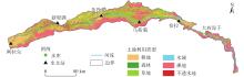
图1
塔里木河干流地理位置"

表1
各指标计算方法"
| 成分 | 指标 | 公式 | 备注 | |
|---|---|---|---|---|
| 绿度 | NDVI | NDVI为归一化植被指数; | ||
| 湿度 | WET | |||
| 热度 | LST | LST为地表温度(℃);ND为不同传感器的影像像元灰度值 | ||
| 干度 | NDBSI | NDBSI为干度指数;SI为裸土指数 | ||
| 盐度 | SI_T | SI_T、SI_1、SI_2为盐度指数 | ||
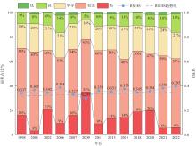
图2
1998—2022年生态环境质量面积占比 注:RSEIS为改进型遥感生态指数。"

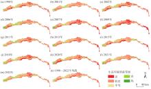
图3
1998—2022年生态环境质量空间分布"
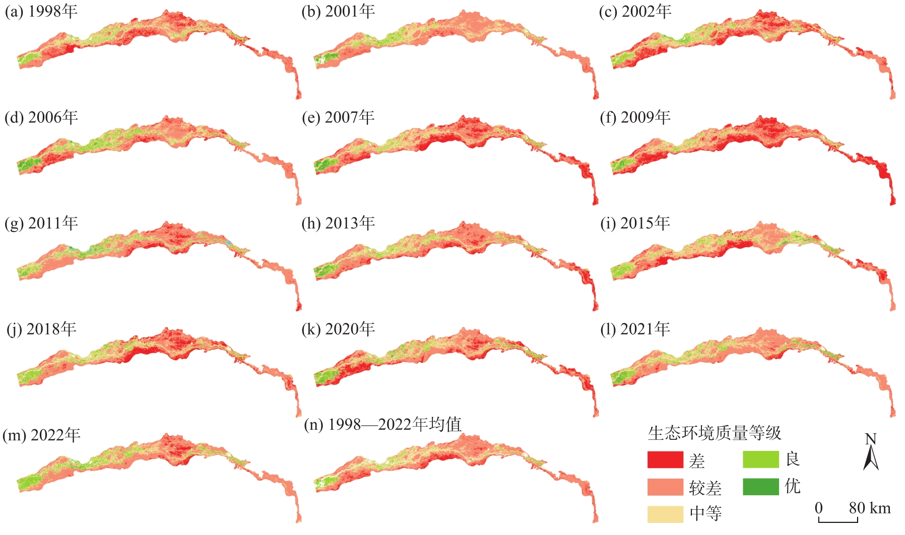
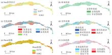
图4
1998—2022年生态环境质量变化趋势分析"

表2
生态环境质量空间变化趋势面积占比"
| 变化趋势 | 变异系数 | 未来趋势 | ||||||||
|---|---|---|---|---|---|---|---|---|---|---|
| 类型 | 面积/km2 | 占比/% | 类型 | 面积/km2 | 占比/% | 类型 | 面积/km2 | 占比/% | ||
| 显著恶化 | 917.94 | 4.74 | 低波动 | 608.71 | 3.14 | 持续退化 | 95.34 | 0.49 | ||
| 轻微恶化 | 6358.72 | 32.85 | 相对低波动 | 10569.93 | 54.60 | 未来退化 | 10568.02 | 54.59 | ||
| 不变 | 1423.06 | 7.35 | 中等波动 | 6396.85 | 33.04 | 稳定不变 | 1348.17 | 6.97 | ||
| 轻微改善 | 8137.86 | 42.04 | 相对高波动 | 1345.66 | 6.96 | 未来改善 | 7196.16 | 37.17 | ||
| 显著改善 | 2521.33 | 13.02 | 高波动 | 437.75 | 2.26 | 持续改善 | 151.20 | 0.78 | ||
表3
1998—2022年生态环境质量因子探测结果"
| 影响因子 | 1998年 | 2002年 | 2007年 | 2013年 | 2018年 | 2022年 | 均值 | ||||||||||||
|---|---|---|---|---|---|---|---|---|---|---|---|---|---|---|---|---|---|---|---|
| q | P | q | P | q | P | q | P | q | P | q | P | q | |||||||
| DMSP | 0.011 | 0 | 0.009 | 0 | 0.015 | 0 | 0.080 | 0 | 0.066 | 0 | 0.170 | 0 | 0.058 | ||||||
| AS | 0.003 | 0 | 0.003 | 0 | 0.002 | 0 | 0.002 | 0 | 0.002 | 0 | 0.002 | 0 | 0.003 | ||||||
| SL | 0.020 | 0 | 0.023 | 0 | 0.021 | 0 | 0.019 | 0 | 0.021 | 0 | 0.021 | 0 | 0.021 | ||||||
| LUCC | 0.508 | 0 | 0.455 | 0 | 0.575 | 0 | 0.559 | 0 | 0.551 | 0 | 0.555 | 0 | 0.534 | ||||||
| TEMP | 0.077 | 0 | 0.205 | 0 | 0.208 | 0 | 0.234 | 0 | 0.090 | 0 | 0.128 | 0 | 0.157 | ||||||
| POP | 0.113 | 0 | 0.014 | 0 | 0.017 | 0 | 0.055 | 0 | 0.013 | 0 | 0.041 | 0 | 0.042 | ||||||
| PET | 0.565 | 0 | 0.564 | 0 | 0.409 | 0 | 0.511 | 0 | 0.437 | 0 | 0.429 | 0 | 0.486 | ||||||
| PRE | 0.137 | 0 | 0.144 | 0 | 0.057 | 0 | 0.115 | 0 | 0.105 | 0 | 0.119 | 0 | 0.113 | ||||||
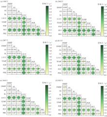
图5
1998—2022年生态环境质量驱动因子交互作用 注:DMSP为夜间灯光指数;AS为坡向;SL为坡度;LUCC为土地利用类型;TEMP为气温;POP为人口;PET为潜在蒸散发;PRE为降水量。"

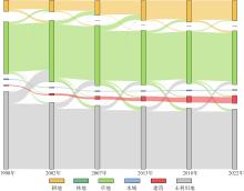
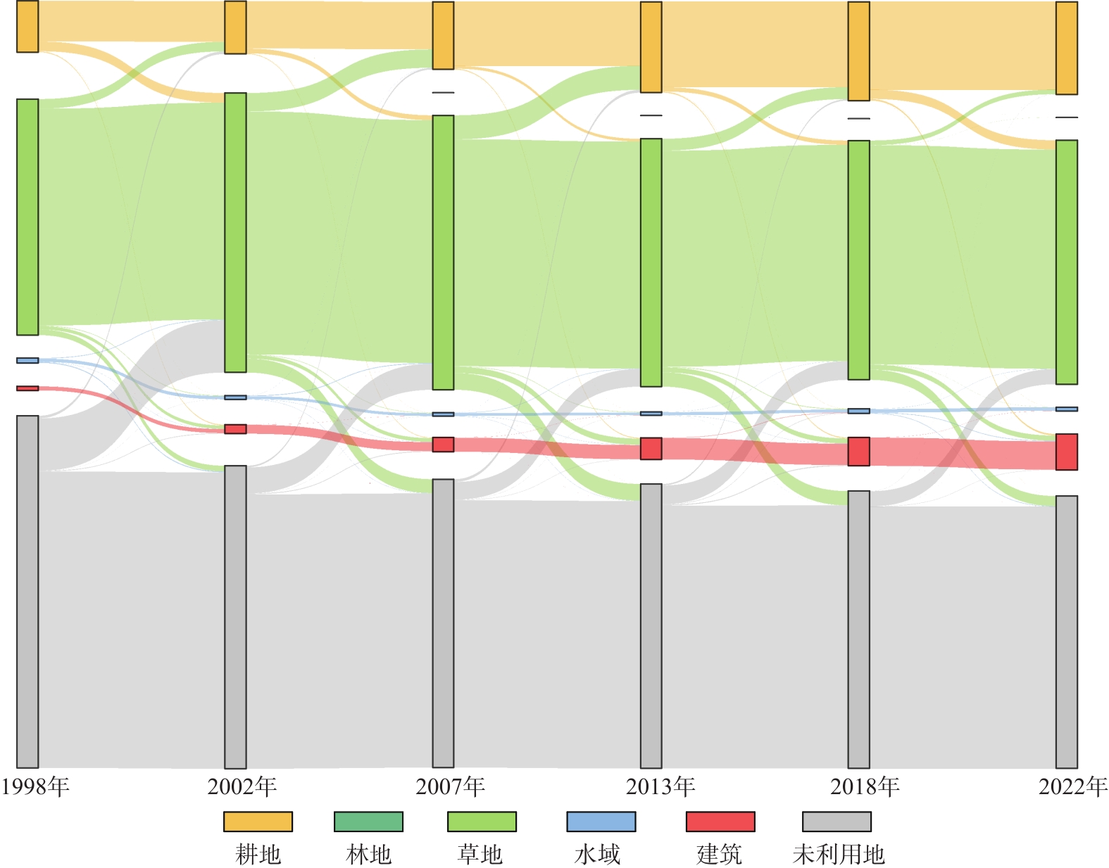
图6
1998—2022年研究区土地利用桑基图"
| [1] | Che L S, Yin S Y, Jin J F, et al. Assessment and simulation of urban ecological environment quality based on geographic information system ecological index[J]. Land, 2024, 13(5): 687, doi: 10.3390/land13050687. |
| [2] | Singh V, Nema A K, Chouksey A, et al. Assessment of eco-environmental vulnerability using remote sensing and GIS tools in Maharashtra region, India[J]. International Journal of Environment and Climate Change, 2024, 14(4): 119-129. |
| [3] | Zhu C G, Shen Q, Zhang K, et al. Multiscale detection and assessment of vegetation eco-environmental restoration following ecological water compensation in the lower reaches of the Tarim River, China[J]. Remote Sensing, 2022, 14(22): 5855, doi: 10.3390/rs14225855. |
| [4] |
胡瑞媛, 畅建霞, 郭爱军, 等. 塔里木河干流生态系统变化与生态效益分析[J]. 干旱区地理, 2024, 47(4): 622-633.
doi: 10.12118/j.issn.1000-6060.2023.254 |
|
[Hu Ruiyuan, Chang Jianxia, Guo Aijun, et al. Ecosystem variation and ecological benefits analysis of the mainstream of Tarim River[J]. Arid Land Geography, 2024, 47(4): 622-633. ]
doi: 10.12118/j.issn.1000-6060.2023.254 |
|
| [5] | 徐涵秋. 区域生态环境变化的遥感评价指数[J]. 中国环境科学, 2013, 33(5): 889-897. |
| [Xu Hanqiu. A remote sensing index for assessment of regional ecological changes[J]. China Environmental Science, 2013, 33(5): 889-897. ] | |
| [6] | Aurora R M, Furuya K. Spatiotemporal analysis of urban sprawl and ecological quality study case: Chiba Prefecture, Japan[J]. Land, 2023, 12(11): 2013, doi: 10.3390/land12112013. |
| [7] | Shi M, Lin F, Jing X, et al. Ecological environment quality assessment of arid areas based on improved remote sensing ecological index: A case study of the Loess Plateau[J]. Sustainability, 2023, 15(18): 13881, doi: 10.3390/su151813881. |
| [8] | Zhang K L, Feng R R, Zhang Z C, et al. Exploring the driving factors of remote sensing ecological index changes from the perspective of geospatial differentiation: A case study of the Weihe River Basin, China[J]. International Journal of Environmental Research and Public Health, 2022, 19(17): 10930, doi: 10.3390/ijerph191710930. |
| [9] | 李蕊, 陈国清, 李玮贤, 等. 基于遥感生态指数的神东矿区1995—2020年生态环境质量的时空变化特征分析[J]. 水土保持通报, 2021, 41(3): 143-151. |
| [Li Rui, Chen Guoqing, Li Weixian, et al. Spatiotemporal analysis of eco-environmental benefits in Shenfu-Dongsheng mining area during 1995—2020 based on RSEI[J]. Bulletin of Soil and Water Conservation, 2021, 41(3): 143-151. ] | |
| [10] | 张伟, 杜培军, 郭山川, 等. 改进型遥感生态指数及干旱区生态环境评价[J]. 遥感学报, 2023, 27(2): 299-317. |
| [Zhang Wei, Du Peijun, Guo Shanchuan, et al. Enhanced remote sensing ecological index and ecological environment evaluation in arid area[J]. National Remote Sensing Bulletin, 2023, 27(2): 299-317. ] | |
| [11] | Duo L H, Wang J Q, Zhang F Q, et al. Assessing the spatiotemporal evolution and drivers of ecological environment quality using an enhanced remote sensing ecological index in Lanzhou City, China[J]. Remote Sensing, 2023, 15(19): 4704, doi: 10.3390/rs15194704. |
| [12] | 楚智, 徐长春, 罗映雪, 等. 基于生态保护红线管理的塔里木河流域土地利用模拟及生态效益评价[J]. 生态学报, 2021, 41(18): 7380-7392. |
| [Chu Zhi, Xu Changchun, Luo Yingxue, et al. Land use simulation and ecological benefit evaluation in the Tarim River Basin based on ecological protection red line management[J]. Acta Ecologica Sinica, 2021, 41(18): 7380-7392. ] | |
| [13] | Jiao A Y, Wang W Q, Ling H B, et al. Effect evaluation of ecological water conveyance in Tarim River Basin, China[J]. Frontiers in Environmental Science, 2022, 10: 1019695, doi: 10.3389/fenvs.2022.1019695. |
| [14] | Wang G Y, Ran G Y, Chen Y N, et al. Landscape ecological risk assessment for the Tarim River Basin on the basis of land-use change[J]. Remote Sensing, 2023, 15(17): 4173, doi: 10.3390/rs15174173. |
| [15] | Chen W, Wang J J, Ding J L, et al. Detecting long-term series eco-environmental quality changes and driving factors using the remote sensing ecological index with salinity adaptability (RSEI SI): A case study in the Tarim River Basin, China[J]. Land, 2023, 12(7): 1309, doi: 10.3390/land12071309. |
| [16] | 王星, 霍艾迪, 吕继强, 等. 塔里木河干流植被覆盖度动态变化及驱动因素分析[J]. 农业工程学报, 2023, 39(8): 284-292. |
| [Wang Xing, Huo Aidi, Lü Jiqiang, et al. Dynamic changes and driving factors of vegetation coverage in the mainstream of Tarim River, China[J]. Transactions of the Chinese Society of Agricultural Engineering, 2023, 39(8): 284-292. ] | |
| [17] | 任强, 龙爱华, 杨永民, 等. 近20年塔里木河干流生态环境变化遥感监测分析[J]. 水利水电技术(中英文), 2021, 52(3): 103-111. |
| [Ren Qiang, Long Aihua, Yang Yongmin, et al. Analysis on remote sensing monitoring of eco-environment variation of main stream basin of Tarim River in recent 20 years[J]. Water Resources and Hydropower Engineering, 2021, 52(3): 103-111. ] | |
| [18] | Jiao A Y, Wang Z K, Deng X Y, et al. Eco-hydrological response of water conveyance in the mainstream of the Tarim River, China[J]. Water, 2022, 14(17): 2622, doi: 10.3390/w14172622. |
| [19] | Li X H, Guo M. The impact of salinization and wind erosion on the texture of surface soils: An investigation of paired samples from soils with and without salt crust[J]. Land, 2022, 11(7): 999, doi: 10.3390/land11070999. |
| [20] | 谭克龙, 王晓峰, 高会军, 等. 塔里木河流域综合治理生态要素变化的遥感分析[J]. 地球信息科学学报, 2013, 15(4): 604-610. |
| [Tan Kelong, Wang Xiaofeng, Gao Huijun, et al. Analysis of ecological elements of comprehensive harnessing in Tarim River Basin using remote sensing[J]. Geo-information Science, 2013, 15(4): 604-610. ] | |
| [21] | Khan N M, Rastoskuev V V, Sato Y, et al. Assessment of hydrosaline land degradation by using a simple approach of remote sensing indicators[J]. Agricultural Water Management, 2004, 77(1): 96-109. |
| [22] | Douaoui A E K, Nicolas H, Walter C. Detecting salinity hazards within a semiarid context by means of combining soil and remote-sensing data[J]. Geoderma, 2005, 134(1): 217-230. |
| [23] | Brunner P, Li T H, Kinzelbach W, et al. Generating soil electrical conductivity maps at regional level by integrating measurements on the ground and remote sensing data[J]. International Journal of Remote Sensing, 2007, 28(15-16): 3341-3361. |
| [24] | 古力米热·哈那提, 张音, 关东海, 等. 生态输水条件下塔里木河下游断面尺度地下水流数值模拟[J]. 水科学进展, 2020, 31(1): 61-70. |
| [Hanati Gulimire, Zhang Yin, Guan Donghai, et al. Numerical simulation of groundwater flow at cross-section scale in the lower reaches of Tarim River under the condition of ecological water conveyance[J]. Advances in Water Science, 2020, 31(1): 61-70. ] | |
| [25] |
吝静, 赵成义, 马晓飞, 等. 基于生态系统服务价值的塔里木河干流土地利用结构优化[J]. 干旱区研究, 2021, 38(4): 1140-1151.
doi: 10.13866/j.azr.2021.04.26 |
|
[Lin Jing, Zhao Chengyi, Ma Xiaofei, et al. Optimization of land use structure based on ecosystem service value in the mainstream of Tarim River[J]. Arid Zone Research, 2021, 38(4): 1140-1151. ]
doi: 10.13866/j.azr.2021.04.26 |
|
| [26] | 罗敏, 古丽·加帕尔, 郭浩, 等. 2000—2013年塔里木河流域生长季NDVI时空变化特征及其影响因素分析[J]. 自然资源学报, 2017, 32(1): 50-63. |
| [Luo Min, Jiapaer Guli, Guo Hao, et al. Spatial-temporal variation of growing-season NDVI and its responses to hydrothermal condition in the Tarim River Basin from 2000 to 2013[J]. Journal of Natural Resources, 2017, 32(1): 50-63. ] | |
| [27] |
罗镕基, 王宏涛, 王成. 基于改进遥感生态指数的甘肃省古浪县生态质量评价[J]. 干旱区地理, 2023, 46(4): 539-549.
doi: 10.12118/j.issn.1000-6060.2022.322 |
|
[Luo Rongji, Wang Hongtao, Wang Cheng. Ecological quality evaluation of Gulang County in Gansu Province based on improved remote sensing ecological index[J]. Arid Land Geography, 2023, 46(4): 539-549. ]
doi: 10.12118/j.issn.1000-6060.2022.322 |
|
| [28] | 王枭轩, 左小清, 杨泽楠, 等. 基于Mann-Kendall检验和信息熵的成都市1980—2016年降水时空变化[J]. 中国水土保持科学, 2019, 17(4): 26-33. |
| [Wang Xiaoxuan, Zuo Xiaoqing, Yang Zenan, et al. Spatio-temporal changes of precipitation in Chengdu from 1980 to 2016 based on Mann-Kendall test and information entropy[J]. Science of Soil and Water Conservation, 2019, 17(4): 26-33. ] | |
| [29] | 马云飞, 陈长胜, 袁福香, 等. 东北虎豹国家公园生态环境质量动态评价及其气候响应[J]. 生态学报, 2023, 43(7): 2614-2626. |
| [Ma Yunfei, Chen Changsheng, Yuan Fuxiang, et al. Dynamic evaluation of ecological environment quality and climate response in Northeastern China Tiger and Leopard National Park[J]. Acta Ecologica Sinica, 2023, 43(7): 2614-2626. ] | |
| [30] | 曾杰, 李江风, 姚小薇. 武汉城市圈生态系统服务价值时空变化特征[J]. 应用生态学报, 2014, 25(3): 883-891. |
|
[Zeng Jie, Li Jiangfeng, Yao Xiaowei. Spatio-temporal dynamics of ecosystem service value in Wuhan urban agglomeration[J]. Chinese Journal of Applied Ecology, 2014, 25(3): 883-891. ]
pmid: 24984511 |
|
| [31] |
王劲峰, 徐成东. 地理探测器: 原理与展望[J]. 地理学报, 2017, 72(1): 116-134.
doi: 10.11821/dlxb201701010 |
| [Wang Jinfeng, Xu Chengdong. Geodetector: Principle and prospective[J]. Journal of Geographical Sciences, 2017, 72(1): 116-134. ] | |
| [32] | Yang X Y, Meng F, Fu P J, et al. Time-frequency optimization of RSEI: A case study of Yangtze River Basin[J]. Ecological Indicators, 2022, 141: 109080, doi: 10.1016/j.ecolind.2022.109080. |
| [33] | 王小娜, 田金炎, 李小娟, 等. Google Earth Engine云平台对遥感发展的改变[J]. 遥感学报, 2022, 26(2): 299-309. |
| [Wang Xiaona, Tian Jinyan, Li Xiaojuan, et al. Benefits of google earth engine in remote sensing[J]. National Remote Sensing Bulletin, 2022, 26(2): 299-309. ] | |
| [34] | Xia T T, Xue X, Wang H W, et al. Mechanism of vegetation greenness change and its correlation with terrestrial water storage in the Tarim River Basin[J]. Land, 2024, 13(5): 712, doi: 10.3390/land13050712. |
| [35] | Liu Y, Xue J, Gui D W, et al. Agricultural oasis expansion and its impact on oasis landscape patterns in the southern margin of Tarim Basin, northwest China[J]. Sustainability, 2018, 10(6): 1957, doi: 10.3390/su10061957. |
| [36] | Zhang J J, Hao X M, Li X W, et al. Evaluation and regulation strategy for ecological security in the Tarim River Basin based on the ecological footprint[J]. Journal of Cleaner Production, 2024, 435: 140488, doi: 10.1016/j.jclepro.2023.140488. |
| [37] |
张齐飞, 陈亚宁, 孙从建, 等. 塔里木河流域水储量变化及绿洲生态安全评估[J]. 干旱区地理, 2024, 47(1): 1-14.
doi: 10.12118/j.issn.1000-6060.2023.247 |
|
[Zhang Qifei, Chen Yaning, Sun Congjian, et al. Changes in terrestrial water storage and evaluation of oasis ecological security in the Tarim River Basin[J]. Arid Land Geography, 2024, 47(1): 1-14. ]
doi: 10.12118/j.issn.1000-6060.2023.247 |
|
| [38] |
张久丹, 李均力, 包安明, 等. 2013—2020年塔里木河流域胡杨林生态恢复成效评估[J]. 干旱区地理, 2022, 45(6): 1824-1835.
doi: 10.12118/j.issn.1000-6060.2022.082 |
|
[Zhang Jiudan, Li Junli, Bao Anming, et al. Effectiveness assessment of ecological restoration of Populus euphratica forest in the Tarim River Basin during 2013—2020[J]. Arid Land Geography, 2022, 45(6): 1824-1835. ]
doi: 10.12118/j.issn.1000-6060.2022.082 |
|
| [39] | Hou Y F, Chen Y N, Ding J L, et al. Ecological impacts of land use change in the arid Tarim River Basin of China[J]. Remote Sensing, 2022, 14(8): 1894, doi: 10.3390/rs14081894. |
| [40] | 王璐晨, 韩海辉, 张俊, 等. 塔里木河流域土地利用及人类活动强度的时空演化特征研究[J]. 中国地质, 2024, 51(1): 203-220. |
| [Wang Luchen, Han Haihui, Zhang Jun, et al. Spatio-temporal evolution of land use and human activity intensity in the Tarim River Basin, Xinjiang[J]. Geology in China, 2024, 51(1): 203-220. ] | |
| [41] |
李玉朋, 陈亚宁, 叶朝霞, 等. 塔里木河下游输水20 a的生态响应[J]. 干旱区地理, 2021, 44(3): 700-707.
doi: 10.12118/j.issn.1000–6060.2021.03.12 |
|
[Li Yupeng, Chen Yaning, Ye Zhaoxia, et al. Ecological responses of ecological water conveyance in the lower reaches of Tarim River for 20 years[J]. Arid Land Geography, 2021, 44(3): 700-707. ]
doi: 10.12118/j.issn.1000–6060.2021.03.12 |
|
| [42] | 胡瑞媛, 畅建霞, 邓铭江, 等. 生态输水工程对水系连通的多维影响: 以塔里木河为例[J]. 水利学报, 2023, 54(11): 1359-1370. |
| [Hu Ruiyuan, Chang Jianxia, Deng Mingjiang, et al. Multi-dimensional response of hydrological connectivity to ecological water conveyance project[J]. Journal of Hydraulic Engineering, 2023, 54(11): 1359-1370. ] | |
| [43] | 王悦, 蒋志辉, 褚家琦, 等. 塔里木河流域农业水土资源时空匹配关系研究[J]. 农业资源与环境学报, 2024, 41(2): 360-370. |
| [Wang Yue, Jiang Zhihui, Chu Jiaqi, et al. Study on the spatiotemporal matching relationship of agricultural water and land resources in the Tarim River Basin[J]. Journal of Agricultural Resources and Environment, 2024, 41(2): 360-370. ] | |
| [44] | 魏光辉, 桂东伟, 赵新风. 不同水平年塔里木河流域“四源一干”可承载灌溉面积研究[J]. 干旱区地理, 2018, 41(2): 230-237. |
| [Wei Guanghui, Gui Dongwei, Zhao Xinfeng. Irrigation area carrying capacity in Tarim River Basin in different years[J]. Arid Land Geography, 2018, 41(2): 230-237. ] | |
| [45] |
孔子洁, 邓铭江, 凌红波, 等. 塔里木河下游河道断流区生态安全评估与生态恢复对策[J]. 干旱区研究, 2021, 38(4): 1128-1139.
doi: 10.13866/j.azr.2021.04.25 |
|
[Kong Zijie, Deng Mingjiang, Ling Hongbo, et al. Ecological security assessment and ecological restoration countermeasures in the dry-up area of the lower Tarim River[J]. Arid Zone Research, 2021, 38(4): 1128-1139. ]
doi: 10.13866/j.azr.2021.04.25 |
| [1] | 黄学煜, 修丽娜, 陆志翔. 陇东黄土高原生态系统服务权衡效应及其驱动因素[J]. 干旱区地理, 2025, 48(3): 480-493. |
| [2] | 李康宁, 林伊琳, 赵俊三, 王健, 葛峰. 三江源植被覆盖变化驱动机制及生态脆弱性分析[J]. 干旱区地理, 2025, 48(2): 283-295. |
| [3] | 程云洁, 杨淋杰. 中国旅游双循环市场效率空间演进及驱动因素异质性研究[J]. 干旱区地理, 2024, 47(9): 1606-1616. |
| [4] | 朱磊, 李燕楠, 徐佳慧, 胡静, 朱芳, 梁茫茫. 中国冰雪旅游地空间分布格局及成因[J]. 干旱区地理, 2024, 47(8): 1399-1410. |
| [5] | 张晓东, 武丹, 王莹, 赵银鑫, 马瑜, 马玉学, 倪海玲. 耦合InVEST与Geodetector模型的银川市生境质量时空演变特征及影响因子研究[J]. 干旱区地理, 2024, 47(7): 1242-1251. |
| [6] | 赵雪纯, 菊春燕. 公园绿地与城市功能空间耦合协调关系及影响因素分析——以乌鲁木齐市为例[J]. 干旱区地理, 2024, 47(5): 898-908. |
| [7] | 卢冬燕, 朱秀芳, 唐明秀, 郭春华, 刘婷婷. 不同温升情景下中国旱灾风险变化评估[J]. 干旱区地理, 2024, 47(3): 369-379. |
| [8] | 王剑, 管瑶, 贺兴宏, 代云豪, 陈艺伟, 王育强, 李会文, 范德宝. 2000—2021年图木舒克市生态环境质量动态监测与评价[J]. 干旱区地理, 2024, 47(3): 465-473. |
| [9] | 李俊佳, 赵美风. 中国民族地区高质量发展空间演变及其影响机理[J]. 干旱区地理, 2024, 47(3): 496-505. |
| [10] | 陈繁繁, 白永平, 梁建设, 张春悦, 赵越, 龚享林. 兰州市蔬菜市场的空间分布特征及影响因素研究[J]. 干旱区地理, 2024, 47(2): 293-306. |
| [11] | 慕石雷, 杨玉欢, 乌日陶克套胡. 国家沙漠(石漠)公园空间分异格局与影响因素[J]. 干旱区地理, 2024, 47(2): 356-368. |
| [12] | 李世娇, 张珂珂, 谢宝妮, 王世文, 李治广. 基于遥感的库尔勒地区生态环境质量评价及成因分析[J]. 干旱区地理, 2024, 47(12): 2064-2074. |
| [13] | 周孝明, 张喆, 张越, 王俣凝. 基于TVDI的近20 a吐鲁番市干旱及影响因素分析[J]. 干旱区地理, 2024, 47(12): 2104-2114. |
| [14] | 王紫彦, 牛莉芹, 程占红. 生态福利绩效时空演化及影响因素研究——以山西省为例[J]. 干旱区地理, 2024, 47(12): 2152-2163. |
| [15] | 杨雨, 宋福铁, 张杰. 基于地理探测器的中国金融网络空间结构特征及影响因素研究[J]. 干旱区地理, 2023, 46(9): 1524-1535. |
|
||