- 2025年4月13日 星期日
干旱区地理 ›› 2021, Vol. 44 ›› Issue (6): 1821-1835.doi: 10.12118/j.issn.1000–6060.2021.06.29
牛雅萱1,2,3( ),吴世新1,2(),郭晨宇1,2,3,庄庆威1,2,3,谢聪慧1,2,3,张子慧1,2,3,罗格平1,2
收稿日期:2020-11-16
修回日期:2021-04-12
出版日期:2021-11-25
发布日期:2021-12-03
通讯作者:
吴世新
作者简介:牛雅萱(1995-),女,硕士研究生,主要从事土地利用研究. E-mail: 基金资助:
NIU Yaxuan1,2,3(),WU Shixin1,2(),GUO Chenyu1,2,3,ZHUANG Qingwei1,2,3,XIE Conghui1,2,3,ZHANG Zihui1,2,3,LUO Geping1,2
Received:2020-11-16
Revised:2021-04-12
Online:2021-11-25
Published:2021-12-03
Contact:
Shixin WU
摘要:
基于“生产-生活-生态”功能视角构建评价体系并引入耦合协调模型,探究新疆县市土地功能及功能间相互作用程度的时空演变规律,遴选影响区域发展的关键因子,为区域发展提供建议。研究结果表明:(1) 新疆县市单元生产功能,生活功能,生态功能及“三生”功能综合评价的时空格局分布差异性显著,均呈现“北高南低”的空间分布特征,以天山北坡城市群为核心高值区。(2) 新疆县市“三生”功能耦合协调性总体呈现“北高南低”空间分布态势,县市功能间的耦合协调关系逐步向好,为区域后续的发展奠定了良好基础。(3) 主导产业的选择对于新疆县市功能发展至关重要,同时宏观政策调控有助于功能间的耦合协调性提升,推动县市功能协调有序发展。
牛雅萱,吴世新,郭晨宇,庄庆威,谢聪慧,张子慧,罗格平. 新疆县市“三生”功能时空变化及耦合协调性分析[J]. 干旱区地理, 2021, 44(6): 1821-1835.
NIU Yaxuan,WU Shixin,GUO Chenyu,ZHUANG Qingwei,XIE Conghui,ZHANG Zihui,LUO Geping. Spatio-temporal changes and coupling coordination of the function of “production-living-ecological” in Xinjiang[J]. Arid Land Geography, 2021, 44(6): 1821-1835.

图1
研究区概况 注:该图基于审图号为新S(2018)033号的标准地图制作,底图无修改。下同。"

表1
“三生”功能评价指标体系服务准则及指标权重划分"
| 县市国土空间三生功能 | 一级指标 | 二级指标 | 熵值法权重 | 层次法权重 | 综合权重 |
|---|---|---|---|---|---|
| 生产功能 | 农业生产功能 | 耕地面积/km2 | 0.0565 | 0.0371 | 0.0468 |
| 粮食总产量/t | 0.0585 | 0.0486 | 0.0535 | ||
| 人均耕地面积/km2 | 0.0546 | 0.0164 | 0.0355 | ||
| 农业生产总值/104元 | 0.0563 | 0.0657 | 0.0610 | ||
| 人均粮食产量/kg·人-1 | 0.0565 | 0.0216 | 0.0390 | ||
| 人均农业生产总值/元·人-1 | 0.0530 | 0.0282 | 0.0406 | ||
| 人均肉类产量/t | 0.0592 | 0.0126 | 0.0359 | ||
| 农业机械总动力/kW | 0.0571 | 0.0097 | 0.0334 | ||
| 非农业生产功能 | 工业总产值/104元 | 0.0896 | 0.0830 | 0.0863 | |
| 交通及仓储邮政规模/104元 | 0.0665 | 0.0076 | 0.0371 | ||
| GDP空间评价/GDP·km-2 | 0.0894 | 0.0062 | 0.0478 | ||
| 单位生产总值地耗/km2`GDP-1 | 0.0554 | 0.0051 | 0.0302 | ||
| 二产贡献率/% | 0.0568 | 0.1080 | 0.0824 | ||
| 三产贡献率/% | 0.0531 | 0.1399 | 0.0965 | ||
| 地区生产总值/104元 | 0.0762 | 0.2299 | 0.1531 | ||
| 人均GDP/104元·人-1 | 0.0613 | 0.1803 | 0.1208 | ||
| 生活功能 | 生活保障功能 | 每万人拥有的病床数 | 0.1335 | 0.0674 | 0.1005 |
| 每万人拥有的医生数 | 0.1324 | 0.1035 | 0.1179 | ||
| 受教育人数占比/% | 0.1183 | 0.1587 | 0.1385 | ||
| 农村居民人均纯收入/元 | 0.1274 | 0.2406 | 0.1840 | ||
| 城镇居民可支配收入/元 | 0.1316 | 0.3558 | 0.2437 | ||
| 社会消费品零售总额/104元 | 0.2082 | 0.0439 | 0.1261 | ||
| 交通用地占建设用地比例/% | 0.1486 | 0.0302 | 0.0894 | ||
| 生态功能 | 生态维持功能 | 新增沙化盐碱化土地面积/km2 | 0.1269 | 0.1228 | 0.1249 |
| 生物丰度指数 | 0.1166 | 0.0367 | 0.0767 | ||
| 植被覆盖度指数 | 0.1252 | 0.0610 | 0.0931 | ||
| 森林面积占比/% | 0.1461 | 0.2311 | 0.1886 | ||
| 草地面积占比/% | 0.1696 | 0.2510 | 0.2103 | ||
| 人均森林面积/km2 | 0.1288 | 0.1398 | 0.1343 | ||
| 人均草地面积/km2 | 0.1868 | 0.1577 | 0.1722 |
表2
耦合协调指数分级"
| 耦合协调指数(D) | 耦合协调类型 | 特征 |
|---|---|---|
| D∈[0.0,0.3] | 重度失调 | 各功能处于低水平发展,功能整体协调性极差。 |
| D∈(0.3,0.4] | 轻度失调 | 功能逐渐发展起来,但总体水平还是较低,功能间协调性较差。 |
| D∈(0.4,0.5] | 低水平基本协调 | 功能整体协调性提高,功能发展相互阻碍现象基本消失。 |
| D∈(0.5,0.6] | 高水平基本协调 | 功能间差距缩小,功能发展由阻碍转变为低水平相互促进。 |
| D∈(0.6,0.8] | 中度协调 | 功能间具有良好的协调互动性,功能相互促进,共同发展。 |
| D∈(0.8,1.0] | 高度协调 | 各功能均处于高水平发展,功能整体协调度极佳。 |
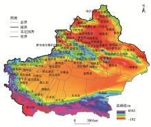
图2
“三生”功能评价空间分布"
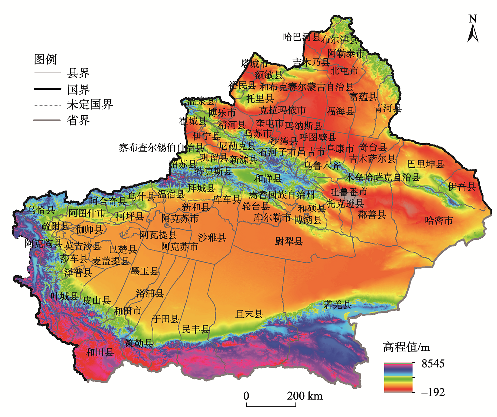

图3
“三生”功能评价县市数量变化分布"

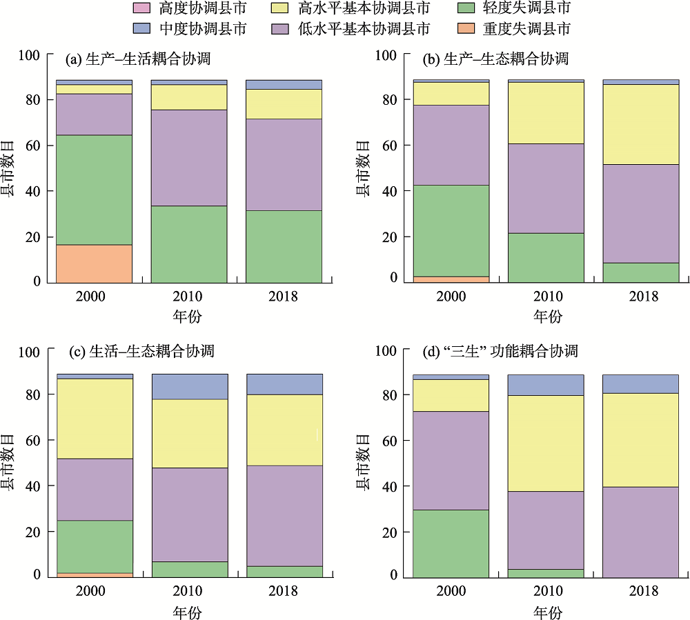
图4
“三生”功能耦合协调指数的空间分布"

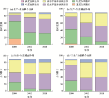
图5
耦合协调指数县市数量变化分布"
| [1] | 张衍毓, 陈美景. 国土空间系统认知与规划改革构想[J]. 中国土地科学, 2016, 30(2):11-21. |
| [ Zhang Yanyu, Chen Meijing. Cognition of land space system and planning reform conception[J]. China Land Science, 2016, 30(2):11-21. ] | |
| [2] |
黄安, 许月卿, 卢龙辉, 等. “生产-生活-生态”空间识别与优化研究进展[J]. 地理科学进展, 2020, 39(3):503-518.
doi: 10.18306/dlkxjz.2020.03.014 |
|
[ Huang An, Xu Yueqing, Lu Longhui, et al. Research progress of the identification and optimization of production-living-ecological spaces[J]. Progress in Geography, 2020, 39(3):503-518. ]
doi: 10.18306/dlkxjz.2020.03.014 |
|
| [3] | 李秋颖, 方创琳, 王少剑. 中国省级国土空间利用质量评价: 基于“三生”空间视角[J]. 地域研究与开发, 2016, 35(5):163-169. |
| [ Li Qiuying, Fang Chuanglin, Wang Shaojian. Evaluation of territorial utilization quality in China: Based on the aspect of production-living-ecological space[J]. Areal Research and Development, 2016, 35(5):163-169. ] | |
| [4] |
刘继来, 刘彦随, 李裕瑞. 中国“三生空间”分类评价与时空格局分析[J]. 地理学报, 2017, 72(7):1290-1304.
doi: 10.11821/dlxb201707013 |
|
[ Liu Jilai, Liu Yansui, Li Yurui. Classification evaluation and spatial-temporal analysis of “production-living-ecological” spaces in China[J]. Acta Geographica Sinica, 2017, 72(7):1290-1304. ]
doi: 10.11821/dlxb201707013 |
|
| [5] | 张红旗, 许尔琪, 朱会义. 中国“三生用地”分类及其空间格局[J]. 资源科学, 2015, 37(7):1332-1338. |
| [ Zhang Hongqi, Xu Erqi, Zhu Huiyi. An ecological-living-industrial land classification system and its spatial distribution in China[J]. Resources Science, 2015, 37(7):1332-1338. ] | |
| [6] |
安悦, 周国华, 贺艳华, 等. 基于“三生”视角的乡村功能分区及调控——以长株潭地区为例[J]. 地理研究, 2018, 37(4):695-703.
doi: 10.11821/dlyj201804004 |
|
[ An Yue, Zhou Guohua, He Yanhua, et al. Research on the functional zoning and regulation of rural areas based on the production-life-ecological function perspective: A case study of Changsha-Zhuzhou-Xiangtan area[J]. Geographic Research, 2018, 37(4):695-703. ]
doi: 10.11821/dlyj201804004 |
|
| [7] | 王璐, 张合兵, 胡文智, 等. 基于“三生”视角的煤粮复合区土地利用功能评价[J]. 水土保持通报, 2018, 38(3):301-306. |
| [ Wang Lu, Zhang Hebing, Hu Wenzhi, et al. Functional evaluation of land use based on production-living-ecology view in areas of cropland and coal resources[J]. Bulletin of Soil and Water Conservation, 2018, 38(3):301-306. ] | |
| [8] |
李广东, 方创琳. 城市生态-生产-生活空间功能定量识别与分析[J]. 地理学报, 2016, 71(1):49-65.
doi: 10.11821/dlxb201601004 |
|
[ Li Guangdong, Fang Chuanglin. Quantitative function identification and analysis of urban ecological-production-living spaces[J]. Acta Geographica Sinica, 2016, 71(1):49-65. ]
doi: 10.11821/dlxb201601004 |
|
| [9] | 崔家兴, 顾江, 孙建伟, 等. 湖北省三生空间格局演化特征分析[J]. 中国土地科学, 2018, 32(8):67-73. |
| [ Cui Jiaxing, Gu Jiang, Sun Jianwei, et al. The spatial pattern and evolution characteristics of the production, living and ecological space in Hubei Province[J]. China Land Science, 2018, 32(8):67-73. ] | |
| [10] | 方创琳, 贾克敬, 李广东, 等. 市县土地生态-生产-生活承载力测度指标体系及核算模型解析[J]. 生态学报, 2017, 37(15):5198-5209. |
| [ Fang Chuanglin, Jia Kejing, Li Guangdong, et al. Theoretical analysis of the index system and calculation model of carrying capacity of land ecological-production-living spaces from county scale[J]. Acta Ecologica Sinica, 2017, 37(15):5198-5209. ] | |
| [11] | 魏小芳, 赵宇鸾, 李秀彬, 等. 基于“三生功能”的长江上游城市群国土空间特征及其优化[J]. 长江流域资源与环境, 2019, 28(5):1070-1079. |
| [ Wei Xiaofang, Zhao Yuluan, Li Xiubin, et al. Characteristics and optimization of geographical space in urban agglomeration in the upper reaches of the Yangtze River based on the function of “production-living-ecological”[J]. Resources and Environment in the Yangtze Basin, 2019, 28(5):1070-1079. ] | |
| [12] | 徐磊, 董捷, 李璐, 等. 基于功能分区视角的长江中游城市群国土空间特征及优化[J]. 经济地理, 2017, 37(6):76-83. |
| [ Xu Lei, Dong Jie, Li Lu, et al. Characteristics and optimization of geographical space in urban agglomeration in the middle reaches of the Yangtze River based on the function zoning[J]. Economic Geography, 2017, 37(6):76-83. ] | |
| [13] | 马世发, 黄宏源, 蔡玉梅, 等. 基于三生功能优化的国土空间综合分区理论框架[J]. 中国国土资源经济, 2014, 27(11):31-34. |
| [ Ma Shifa, Huang Hongyuan, Cai Yumei, et al. Theoretical framework with regard to comprehensive sub-areas of China’s land spaces based on the functional optimization of production, life and ecology[J]. Natural Resource Economics of China, 2014, 27(11):31-34. ] | |
| [14] | 林佳, 宋戈, 张莹. 国土空间系统“三生”功能协同演化机制研究——以阜新市为例[J]. 中国土地科学, 2019, 33(4):9-17. |
| [ Lin Jia, Song Ge, Zhang Ying. Synergistic evolution mechanism of “production-living-ecology” functions in spatial planning system: A case study of Fuxin City[J]. China Land Science, 2019, 33(4):9-17. ] | |
| [15] | 李欣, 方斌, 殷如梦, 等. 江苏省县域“三生”功能时空变化及协同/权衡关系[J]. 自然资源学报, 2019, 34(11):2363-2377. |
| [ Li Xin, Fang Bin, Yin Rumeng, et al. Spatial-temporal change and collaboration/trade-off relationship of “production-living-ecological” functions in county area of Jiangsu Province[J]. Journal of Natural Resources, 2019, 34(11):2363-2377. ] | |
| [16] | 杨士弘. 广州城市环境与经济协调发展预测及调控研究[J]. 地理科学, 1994, 14(2):136-143. |
| [ Yang Shihong. A study on the forecast and regulation of coordinated development of urban environment and economy in Guangzhou[J]. Scientia Geographica Sinica, 1994, 14(2):136-143. ] | |
| [17] | 廖重斌. 环境与经济协调发展的定量评判及其分类体系——以珠江三角洲城市群为例[J]. 广州环境科学, 1996(1):12-16. |
| [ Liao Zhongbin. Quantitative evaluation and classification system of coordinated development of environment and economy: A case study of urban agglomeration in Pearl River Delta[J]. Guangzhou Environmental Science, 1996(1):12-16. ] | |
| [18] | 尚海龙, 潘玉君. 西安市人地关系协调状态评价及动态预测[J]. 人文地理, 2013, 28(2):104-110. |
| [ Shang Hailong, Pan Yujun. The analysis on the evolution state of man-land relationship and the dynamic prediction in Xi’an[J]. Human Geography, 2013, 28(2):104-110. ] | |
| [19] | 纪建悦, 于富洋, 方胜民. 环渤海地区经济与海洋环境的耦合度研究[J]. 海洋环境科学, 2012, 31(6):847-850. |
| [ Ji Jianyue, Yu Fuyang, Fang Shengmin. Study on coupling degree between economy and marine environment in Bohai Sea Rim[J]. Marine Environmental Science, 2012, 31(6):847-850. ] | |
| [20] |
王成, 唐宁. 重庆市乡村三生空间功能耦合协调的时空特征与格局演化[J]. 地理研究, 2018, 37(6):1100-1114.
doi: 10.11821/dlyj201806004 |
|
[ Wang Cheng, Tang Ning. Spatio-temporal characteristics and evolution of rural production-living-ecological space function coupling coordination in Chongqing Municipality[J]. Geography Research, 2018, 37(6):1100-1114. ]
doi: 10.11821/dlyj201806004 |
|
| [21] |
Zhang Y, Su Z, Li G, et al. Spatial-temporal evolution of sustainable urbanization development: A perspective of the coupling coordination development based on population, industry, and built-up land spatial agglomeration[J]. Sustainability, 2018, 10(6):1766, doi: 10.3390/su10061766.
doi: 10.3390/su10061766 |
| [22] | 甄霖, 曹淑艳, 魏云洁, 等. 土地空间多功能利用: 理论框架及实证研究[J]. 资源科学, 2009, 31(4):544-551. |
| [ Zhen Lin, Cao Shuyan, Wei Yunjie, et al. Land use functions: Conceptual framework and application for China[J]. Resources Science, 2009, 31(4):544-551. ] | |
| [23] | 姜逢清, 朱诚, 穆桂金, 等. 新疆绿洲当代人地关系紧张情势与缓解途径[J]. 地理科学, 2003, 23(2):157-163. |
| [ Jiang Fengqing, Zhu Cheng, Mu Guijin, et al. Present situation of the man-land relationship inconsistency in the oases of Xinjiang and the mitigation measures[J]. Scientia Geographica Sinica, 2003, 23(2):157-163. ] | |
| [24] | 刘晓婷, 陈闻君. 2004—2013年新疆县域经济空间差异演化[J]. 中国沙漠, 2015, 35(4):1089-1095. |
| [ Liu Xiaoting, Chen Wenjun. Dynamics of spatial pattern of county’s economics during 2004—2013 in Xinjiang, China[J]. Journal of Desert Research, 2015, 35(4):1089-1095. ] | |
| [25] | 张锦宗, 梁进社, 朱瑜馨. 新疆县域经济分异特征、原因及对策探讨[J]. 地理科学, 2010, 30(4):536-543. |
| [ Zhang Jinzong, Liang Jinshe, Zhu Yuxin. The characteristics, reasons, and measures of county economic division of Xinjiang[J]. Scientia Geographica Sinica, 2010, 30(4):536-543. ] | |
| [26] | 王静, 张小雷, 杜宏茹. 新疆县域经济空间格局演化特征[J]. 地理科学进展, 2011, 30(4):470-478. |
| [ Wang Jing, Zhang Xiaolei, Du Hongru. The characteristics, reasons, and measures of county economic division of Xinjiang[J]. Progress in Geography, 2011, 30(4):470-478. ] | |
| [27] | 刘超, 许月卿, 刘焱序, 等. 基于系统论的土地利用多功能分类及评价指标体系研究[J]. 北京大学学报(自然科学版), 2018, 54(1):181-188. |
| [ Liu Chao, Xu Yueqing, Liu Yanxu, et al. Research on land use functions classification and evaluation system based on system theory[J]. Journal of Peking University (Natural Science Edition), 2018, 54(1):181-188. ] | |
| [28] | Chiang C L, Liang J J. An evaluation approach for livable urban environments[J]. Environmental Science & Pollution Research International, 2013, 20(8):5229-5242. |
| [29] | 周华荣. 新疆生态环境质量评价指标体系研究[J]. 中国环境科学, 2000, 20(2):150-153. |
| [ Zhou Huarong. Study on ecological environmental quality as assessment index system of Xinjiang[J]. China Environmental Science, 2000, 20(2):150-153. ] | |
| [30] | 刘方田, 许尔琪. 基于土地利用的新疆兵团与非兵团生境质量时空演变的对比[J]. 应用生态学报, 2020, 31(7):2341-2351. |
| [ Liu Fangtian, Xu Erqi. Comparison of spatial-temporal evolution of habitat quality between Xinjiang Corps and Non-corps Region based on land use[J]. Chinese Journal of Applied Ecology, 2020, 31(7):2341-2351. ] | |
| [31] | 郭显光. 熵值法及其在综合评价中的应用[J]. 财贸研究, 1994(6):56-60. |
| [ Guo Xianguang. Entropy method and its application in comprehensive evaluation[J]. Finance and Trade Research, 1994(6):56-60. ] | |
| [32] | 刘云菲, 李红梅, 马宏阳. 中国农垦农业现代化水平评价研究——基于熵值法与TOPSIS方法[J]. 农业经济问题, 2021(2):107-116. |
| [ Liu Yunfei, Li Hongmei, Ma Hongyang. Study on the evaluation of agricultural modernization level of China’s state farms: Based on entropy method and TOPSIS method[J]. Issues in Agricultural Economy, 2021(2):107-116. ] | |
| [33] | 郝辑, 张少杰. 基于熵值法的我国省际生态数据评价研究[J]. 情报科学, 2021, 39(1):157-162. |
| [ Hao Ji, Zhang Shaojie. Evaluation of inter-provincial ecological data in China based on entropy method[J]. Information Science, 2021, 39(1):157-162. ] | |
| [34] | 贾海发, 邵磊, 罗珊. 基于熵值法与耦合协调度模型的青海省生态文明综合评价[J]. 生态经济, 2020, 36(11):215-220. |
| [ Jia Haifa, Shao Lei, Luo Shan. Comprehensive evaluation of ecological civilization in Qinghai Province based on entropy method and coupling coordination degree model[J]. Ecological Economy, 2020, 36(11):215-220. ] | |
| [35] | Saaty T L, Kearns K P. The analytic hierarchy process[M]. Oxford, UK: Pergamon Press, 1985. |
| [36] | 蔡楠, 杨扬, 方建德, 等. 基于层次分析法的城市河流生态修复评估[J]. 长江流域资源与环境, 2010, 19(9):1092-1098. |
| [ Cai Nan, Yang Yang, Fang Jiande, et al. Evaluation of urban river ecological remediation by using analytical hierarchy process[J]. Resources and Environment in the Yangtze Basin, 2010, 19(9):1092-1098. ] | |
| [37] | 徐华, 王欢, 鲁守刚, 等. 基于层次分析法的绥中县矿山地质环境质量评价[J]. 安全与环境工程, 2013, 20(6):116-120. |
| [ Xu Hua, Wang Huan, Lu Shougang, et al. Quality assessment of mineral geological environment in Suizhong County based on AHP[J]. Safety and Environmental Engineering, 2013, 20(6):116-120. ] | |
| [38] | 陆添超, 康凯. 熵值法和层次分析法在权重确定中的应用[J]. 电脑编程技巧与维护, 2009(22):19-20. |
| [ Lu Tianchao, Kang Kai. The application of entropy method and AHP in weight determining[J]. Computer Programming Skills Maintenance, 2009(22):19-20. ] | |
| [39] | 李帅, 魏虹, 倪细炉, 等. 基于层次分析法和熵权法的宁夏城市人居环境质量评价[J]. 应用生态学报, 2014, 25(9):2700-2708. |
| [ Li Shuai, Wei Hong, Ni Xilu, et al. Evaluation of urban human settlement quality in Ningxia based on AHP and the entropy method[J]. Chinese Journal of Applied Ecology, 2014, 25(9):2700-2708. ] | |
| [40] | 黄楚珩, 蒋志云, 杨志广, 等. 基于熵值法和层次分析法的广东省水资源安全评价及影响因素分析[J]. 水资源与水工程学报, 2019, 30(5):140-147. |
| [ Huang Chuheng, Jiang Zhiyun, Yang Zhiguang, et al. Evaluation and factors of water resource security of Guangdong Province using entropy value and analytic hierarchy process methods[J]. Journal of Water Resources and Water Engineering, 2019, 30(5):140-147. ] | |
| [41] | 张翔, 李金燕, 郭娇. 基于熵权—耦合协调度模型的水源地可持续发展能力评价[J]. 生态经济, 2020, 36(9):164-168. |
| [ Zhang Xiang, Li Jinyan, Guo Jiao. Evaluation of sustainable development capacity of water sources based on entropy weight-coupling coordination model[J]. Ecological Economy, 2020, 36(9):164-168. ] | |
| [42] | 倪维秋. 中国三大城市群城市土地利用经济、社会、生态效益的耦合协调性及其空间格局[J]. 城市发展研究, 2016, 36(12):69-77. |
| [ Ni Weiqiu. The coupling and coordination relationship and their spatial pattern of urban land use economic, social and ecological benefits of cities in three largest urban agglomerations in China[J]. Urban Development Studies, 2016, 36(12):69-77. ] | |
| [43] | 关靖云, 瓦哈甫·哈力克, 赵恒山, 等. 新疆各县市自我发展能力测算及时空演变分析[J]. 华中师范大学学报(自然科学版), 2015, 49(6):958-966. |
| [ Guan Jingyun, Khalik Vahav, Zhao Hengshan, et al. Estimation and spatio-temporal evolution analysis of self-development capacity in Xinjiang counties[J]. Journal of Central China Normal University (Natural Sciences), 2015, 49(6):958-966. ] | |
| [44] | 张路路, 郑新奇, 孟超, 等. 湖南省土地多功能耦合协调度时空分异[J]. 中国土地科学, 2019, 33(3):85-94. |
| [ Zhang Lulu, Zheng Xinqi, Meng Chao, et al. Spatio-temporal difference of coupling coordination degree of land use functions in Hunan Province[J]. China Land Science, 2019, 33(3):85-94. ] | |
| [45] | 朱彩霞, 孙海清. 生态文明视角云南省森林生态经济耦合系统协调发展研究[J]. 林业经济问题, 2019, 39(5):482-489. |
| [ Zhu Caixia, Sun Haiqing. Study on coordinated development of forest eco-economic coupling system in Yunnan Province from the perspective of ecological civilization[J]. Problems of Forestry Economics, 2019, 39(5):482-489. ] | |
| [46] | 谢炳庚, 陈永林, 李晓青. 耦合协调模型在“美丽中国”建设评价中的运用[J]. 经济地理, 2016, 36(7):38-44. |
| [ Xie Binggeng, Chen Yonglin, Li Xiaoqing. Application of coupling coordination model in the evaluation of “beautiful China” construction[J]. Economic Geography, 2016, 36(7):38-44. ] | |
| [47] | 龙明璐, 贺清云. 农用地集约利用水平与建设用地规模时空耦合分析——以湖南省为例[J]. 水土保持研究, 2020, 27(2):330-336. |
| [ Long Minglu, He Qingyun. Analysis on spatial-temporal coupling of intensive utilization of agricultural land and construction land scale: Taking Hunan Province as an example[J]. Research of Soil and Water Conservation, 2020, 27(2):330-336. ] | |
| [48] | 张景鑫. 基于“三生空间”的区域国土空间利用质量及耦合协调度评价——以苏南城市群为例[J]. 农业科学研究, 2017, 38(3):57-63. |
| [ Zhang Jingxin. Assessment of land space utilization quality and its coupling and coordination based on producing, living and ecological: A case study of the southern Jiangsu region[J]. Journal of Agricultural Sciences, 2017, 38(3):57-63. ] | |
| [49] | 赵胡兰, 杨兆萍, 韩芳, 等. 新疆旅游产业-经济发展-生态环境耦合态势分析及预测[J]. 干旱区地理, 2020, 43(4):1146-1154. |
| [ Zhao Hulan, Yang Zhaoping, Han Fang, et al. Analysis and forecast of coupling situation among tourism industry-economic development-ecological environment in Xinjiang[J]. Arid Land Geography, 2020, 43(4):1146-1154. ] | |
| [50] | 匡文慧. 新时代国土空间格局变化和美丽愿景规划实施的若干问题探讨[J]. 资源科学, 2019, 41(1):23-32. |
| [ Kuang Wenhui. Issues regarding on spatial pattern change of national land space and its overall implementation on beautiful vision in new era[J]. Resources Science, 2019, 41(1):23-32. ] | |
| [51] | 力木拉提·吾守尔, 杨德刚, 张仲伍, 等. 天山北坡经济带“组团”点轴城镇空间结构研究[J]. 中国沙漠, 2012, 32(1):252-257. |
| [ Wushouer Limulati, Yang Degang, Zhang Zhongwu, et al. Spatial structure of point-axis city groups on northern slope of Tianshan Mountains[J]. Journal of Desert Research, 2012, 32(1):252-257. ] | |
| [52] | 唐勇, 李龙姣. 新疆天山北坡经济带城市群联动发展研究[J]. 市场论坛, 2012(7):48-50. |
| [ Tang Yong, Li Longjiao. Study on the linkage development of urban agglomerations in the economic belt on the northern slope of Tianshan Mountains in Xinjiang[J]. Market Forum, 2012(7):48-50. ] | |
| [53] | 张晓莉, 古丽夏提·图尔荪. 新疆南疆三地州可持续脱贫能力探析——基于县域面板数据[J]. 石河子大学学报(哲学社会科学版), 2020, 34(3):70-79. |
| [ Zhang Xiaoli, Tursun Gulixiati. Analysis on the sustainable poverty alleviation ability of three prefectures in southern Xinjiang: Based on county level panel data[J]. Journal of Shihezi University Philosophy and Social Science, 2020, 34(3):70-79. ] | |
| [54] | 庞丽媛, 马晓钰. 贫困地区人均收入与其影响因素分析——以新疆南疆三地州地区为例[J]. 西北人口, 2018, 39(1):119-126. |
| [ Pang Liyuan, Ma Xiaoyu. Per capita income and its influencing factors in poor areas: A case study of southern Xinjiang, three ground state[J]. Northwest Population Journal, 2018, 39(1):119-126. ] | |
| [55] | 秦春艳. 新疆南疆三地州经济发展现状与趋势[J]. 新疆财经, 2013(5):53-59. |
| [ Qin Chunyan. The status quo and tendency of economic development in three regions of southern Xinjiang[J]. Finance Economics of Xinjiang, 2013(5):53-59. ] | |
| [56] | 刘晓婷, 陈闻君. 新疆县域经济发展影响因素的空间差异分析——基于地理加权回归(GWR)模型[J]. 新疆农垦经济, 2015(9):59-65. |
| [ Liu Xiaoting, Chen Wenjun. Spatial difference analysis of influencing factors of county economic development in Xinjiang: Based on geographically weighted regression (GWR) model[J]. Xinjiang State Farms Economy, 2015(9):59-65. ] | |
| [57] | 欧阳金琼, 周传荣, 李文耀. 新疆南疆地区城镇化、产业升级与人口集聚——基于县域统计资料与SDEM模型[J]. 西北人口, 2020, 42(3):1-10. |
| [ Ouyang Jinqiong, Zhou Chuanrong, Li Wenyao. Industrial upgrading, urbanization and population agglomeration in south Xinjiang: Based on county statistics and SDEM models[J]. Northwest Population Journal, 2020, 42(3):1-10. ] | |
| [58] | 黄麟, 祝萍, 曹巍. 中国退耕还林还草对生态系统服务权衡与协同的影响[J]. 生态学报, 2021, 41(3):1178-1188. |
| [ Huang Lin, Zhu Ping, Cao Wei. The impacts of the grain for green project on the trade-off and synergy relationships among multiple ecosystem services in China[J]. Acta Ecologica Sinica, 2021, 41(3):1178-1188. ] | |
| [59] | 热孜娅·阿曼, 方创琳, 赵瑞东. 新疆水资源承载力评价与时空演变特征分析[J]. 长江流域资源与环境, 2020, 29(7):1576-1585. |
| [ Aman Rezia, Fang Chuanglin, Zhao Ruidong. Research on the water resources carrying capacity and spatial-temporal characteristics in Xinjiang[J]. Resources and Environment in the Yangtze Basin, 2020, 29(7):1576-1585. ] | |
| [60] | 李佳伟, 左其亭, 马军霞. 新疆水资源-经济社会-生态环境时空演变特征分析[J]. 北京师范大学学报(自然科学版), 2020, 56(4):591-599. |
| [ Li Jiawei, Zuo Qiting, Ma Junxia. Analysis of spatial and temporal evolution characteristics of water-socioeconomic-ecosystem in Xinjiang[J]. Journal of Beijing Normal University(Natural Science), 2020, 56(4):591-599. ] | |
| [61] | 雷小牛, 张志良, 张爱民, 等. 构建南疆水-生态-经济协调发展水利战略格局的基本思路[J]. 水利发展研究, 2020, 20(7):22-28. |
| [ Lei Xiaoniu, Zhang Zhiliang, Zhang Aimin, et al. The basic idea of constructing the water conservancy strategic pattern of water ecology economy coordinated development in southern Xinjiang[J]. Water Resources Development Research, 2020, 20(7):22-28. ] | |
| [62] | 盂祥兰. 我国宏观统计指标数据有效性的实证检验[J]. 统计与决策, 2011(23):8-12. |
| [ Yu Xianglan. Empirical test on the validity of China’s macro statistical indicators[J]. Statistics & Decision, 2011(23):8-12. ] |
| [1] | 孟晓, 田明华, 杜磊, 马爽. 中国农业农村现代化发展水平测度及其协调性研究[J]. 干旱区地理, 2024, 47(1): 137-146. |
| [2] | 王冠孝,王伟,张娟娟. 乡村旅游与农村人居环境的耦合协调关系及障碍因子诊断——以山西省为例[J]. 干旱区地理, 2024, 47(1): 170-180. |
| [3] | 夏文浩, 王铭扬, 姜磊. 新疆农业碳排放强度时空变化趋势与收敛分析[J]. 干旱区地理, 2023, 46(7): 1145-1154. |
| [4] | 姚岚博, 冶建明, 王芸, 朱现伟. 干旱区人居环境系统耦合协调的时空演变及作用机制研究——以新疆为例[J]. 干旱区地理, 2023, 46(6): 1013-1023. |
| [5] | 杨锐, 李建勇, 王宁练, 陈小俊, 杜建峰, 刘剑波, 韩岳婷. 西天山温泉地区全新世沉积物元素地球化学记录及其古环境意义[J]. 干旱区地理, 2023, 46(6): 900-910. |
| [6] | 张烈琴, 陆亦农, 龙震, 李庆雷, 王涛. 新疆文化旅游空间分布格局[J]. 干旱区地理, 2023, 46(5): 823-833. |
| [7] | 闫新杰, 孙慧, 辛龙. 新疆资源型企业的空间分布与区位选择[J]. 干旱区地理, 2023, 46(4): 678-687. |
| [8] | 张宁,汪子晨,杨肖,陈彤,邢飞. 新疆水资源与农业种植系统耦合协调及时空差异研究——以粮食和棉花种植系统为例[J]. 干旱区地理, 2023, 46(3): 349-359. |
| [9] | 杨玉欢,贺建雄,张新红,芮旸. 中国农文旅耦合协调发展空间分异特征及影响肌理[J]. 干旱区地理, 2023, 46(3): 448-459. |
| [10] | 宁雷,连华,牛月,盛双庆,高泽宇. 城镇发展的收缩状态识别、分类及因素探讨——以黄河流域甘肃段为例[J]. 干旱区地理, 2023, 46(3): 492-504. |
| [11] | 马丽娜, 张飞云, 翟玉鑫, 滕伦, 康建国. 1980—2020年新疆土地利用变化下生态系统服务价值时空演变分析[J]. 干旱区地理, 2023, 46(2): 253-263. |
| [12] | 余其鹰, 胡彩虹, 白云岗, 卢震林, 曹彪, 刘富余, 刘成帅. 新疆洪水预报预警中融雪径流模型应用进展[J]. 干旱区地理, 2023, 46(12): 1951-1962. |
| [13] | 王志强, 姜文桓, 卢诗月. 基于生态网络分析的新疆“水-能-碳”耦合系统特征研究[J]. 干旱区地理, 2023, 46(12): 2005-2016. |
| [14] | 孙宇, 刘维忠, 盛洋. 基于PSR模型的新疆水资源经济生态韧性时空差异及影响因素分析[J]. 干旱区地理, 2023, 46(12): 2017-2028. |
| [15] | 马文江, 白妙琴, 阿迪力·艾合买提, 张德平, 杨忠娜. “双碳”目标下新疆粮食绿色全要素生产率的时空分异及驱动因素分析[J]. 干旱区地理, 2023, 46(12): 2029-2041. |
| Viewed | ||||||||||||||||||||||||||||||||||||||||||||||||||
|
Full text 829
|
|
|||||||||||||||||||||||||||||||||||||||||||||||||
|
Abstract 391
|
|
|||||||||||||||||||||||||||||||||||||||||||||||||
Cited |
|
|||||||||||||||||||||||||||||||||||||||||||||||||
| Shared | ||||||||||||||||||||||||||||||||||||||||||||||||||
|
||