- 2025年8月15日 星期五
干旱区地理 ›› 2023, Vol. 46 ›› Issue (7): 1121-1132.doi: 10.12118/j.issn.1000-6060.2022.503 cstr: 32274.14.ALG2022503
李诗瑶1,2( ),丛士翔1,王融融1,余海龙1(),黄菊莹3
收稿日期:2022-10-08
修回日期:2022-11-27
出版日期:2023-07-25
发布日期:2023-08-03
作者简介:李诗瑶(1996-),女,博士研究生,主要从事数字农业与农业信息化工程研究. E-mail: 基金资助:
LI Shiyao1,2(),CONG Shixiang1,WANG Rongrong1,YU Hailong1(),HUANG Juying3
Received:2022-10-08
Revised:2022-11-27
Published:2023-07-25
Online:2023-08-03
摘要:
精准动态监测干旱胁迫下的玉米冠层叶绿素相对含量对提高我国玉米旱灾预警水平、实现田间精准灌溉具有重要的指示作用。以无人机多光谱影像为数据源,选用多种具有明确物理意义且与玉米冠层叶绿素相对含量SPAD(Soil and plant analyzer development)值相关性强的植被指数,利用多元逐步回归、支持向量机、BP神经网络(Back propagation neural network,BPNN)建立玉米冠层SPAD值的遥感监测模型并验证,选取最优估测模型提取各生育期不同程度干旱胁迫下的玉米冠层SPAD值,分析不同生育期玉米冠层SPAD值变化,探究不同干旱胁迫程度对玉米冠层SPAD值的影响。结果表明:不同生育期的玉米冠层叶绿素敏感的植被指数不同,且各生育期估测能力最优的反演模型不同。对比3种建模方法,BPNN模型的建模结果及验证结果最优,说明其估测能力及稳定性表现最好,可以作为基于无人机多光谱的玉米冠层SPAD值建模的优选方法。此外,干旱胁迫会降低玉米冠层SPAD值遥感监测模型的估测精度,对苗期的影响最为显著。轻度干旱对玉米冠层SPAD值影响不显著,可见玉米对干旱胁迫具有一定的适应性和抗逆性。因此,基于植被指数的BPNN模型可以更好地估算SPAD值,为基于无人机遥感的SPAD值监测提供一种新途径,为干旱胁迫下夏玉米冠层SPAD值的无损监测以及田间水分精准管理提供参考。
李诗瑶, 丛士翔, 王融融, 余海龙, 黄菊莹. 基于无人机多光谱遥感的干旱胁迫下玉米冠层SPAD值监测[J]. 干旱区地理, 2023, 46(7): 1121-1132.
LI Shiyao, CONG Shixiang, WANG Rongrong, YU Hailong, HUANG Juying. Monitoring of maize canopy SPAD value under drought stress based on UAV multi-spectral remote sensing[J]. Arid Land Geography, 2023, 46(7): 1121-1132.
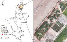
图1
研究区地理位置及小区划分"

表1
无人机及相机主要参数"
| 无人机参数 | 相机参数 | ||
|---|---|---|---|
| 型号 | eBee | 型号 | Parrot Sequoia |
| 起飞重量/kg | 0.64 | 重量/g | 72(相机)+36(光照传感器) |
| 翼展/cm | 96 | 光谱波段 | 绿(550 nm+/-40 nm)、 红(660 nm+/-40 nm)、 红边(735 nm+/-10 nm)、 近红外(790 nm+/-40 nm)、 可见光 |
| 推力 | 电动推杆式螺旋桨,160 w直流电机 | ||
| 续航时间/min | 45 | ||
| 巡航速度/m·s-1 | 10~16 | ||
| 无线电范围/km | 3 | 成像解析度/pixels | 1280×960 |
| 最大覆盖率/km2 | 10 | 分辨率 | 多光谱1.2×10⁶/RGB1600×104 |
表2
植被指数及计算公式"
| 植被指数 | 计算公式 |
|---|---|
| 归一化植被指数(NDVI) | |
| 差值植被指数(DVI) | |
| 比值植被指数(RVI) | |
| 优化土壤调节植被指数(OSAVI) | |
| 归一化绿度指数(GNDVI) | |
| 绿差值植被指数(GDVI) | |
| 绿比值植被指数(GRVI) | |
| 绿色优化土壤调节植被指数(GOSAVI) | |
| 归一化红边指数(RENDVI) | |
| 红边差值植被指数(REDVI) | |
| 红边比值植被指数(RERVI) | |
| 红边优化土壤调节植被指数(REOSAVI) | |
| 三角植被指数(TVI) |
表3
玉米冠层SPAD值与植被指数的相关系数"
| 植被指数 | 苗期 | 拔节期 | 抽雄期 | 完熟期 |
|---|---|---|---|---|
| NDVI | 0.375* | 0.554** | 0.685** | 0.597** |
| DVI | 0.333* | 0.526** | 0.806** | 0.573** |
| RVI | 0.369* | 0.423* | 0.698** | 0.573** |
| OSAVI | 0.373* | 0.552** | 0.770** | 0.633** |
| GNDVI | 0.210 | 0.621** | 0.757** | 0.400* |
| GDVI | 0.185 | 0.506** | 0.814** | 0.479** |
| GRVI | 0.194 | 0.549** | 0.767** | 0.427** |
| GOSAVI | 0.214 | 0.614** | 0.812** | 0.448** |
| RENDVI | 0.129 | 0.577** | 0.758** | 0.580** |
| REDVI | 0.036 | 0.534** | 0.821** | 0.611** |
| RERVI | 0.130 | 0.534** | 0.795** | 0.642** |
| REOSAVI | 0.113 | 0.574** | 0.795** | 0.515** |
| TVI | 0.370* | 0.530** | 0.801** | 0.616** |
表4
不同估测模型的SPAD值建模与验证结果"
| 生育期 | 模型 | 建模变量 | 建模集 | 验证集 | |||
|---|---|---|---|---|---|---|---|
| R2 | RMSE | R2 | RMSE | ||||
| 苗期 | MSR | NDVI、DVI、RVI、OSAVI、TVI | 0.615 | 4.657 | 0.755 | 3.611 | |
| SVM | 0.624 | 4.443 | 0.697 | 3.194 | |||
| BPNN | 0.802 | 3.632 | 0.796 | 3.534 | |||
| 拔节期 | MSR | NDVI、DVI、OSAVI、GNDVI、GDVI、GRVI、GOSAVI、RENDVI、REDVI、RERVI、REOSAVI、TVI | 0.644 | 4.835 | 0.699 | 4.285 | |
| SVM | 0.658 | 4.005 | 0.648 | 4.530 | |||
| BPNN | 0.677 | 3.985 | 0.639 | 4.113 | |||
| 抽雄期 | MSR | 全植被指数 | 0.735 | 4.115 | 0.725 | 4.448 | |
| SVM | 0.634 | 4.178 | 0.778 | 4.682 | |||
| BPNN | 0.678 | 4.580 | 0.821 | 4.178 | |||
| 完熟期 | MSR | NDVI、DVI、RVI、OSAVI、GDVI、GRVI、GOSAVI、RENDVI、REDVI、RERVI、REOSAVI、TVI | 0.619 | 4.642 | 0.616 | 3.574 | |
| SVM | 0.701 | 3.515 | 0.642 | 3.391 | |||
| BPNN | 0.821 | 3.093 | 0.703 | 4.600 | |||
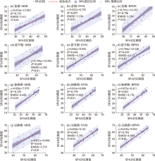
图2
验证集SPAD估测值与实测值拟合结果"

表5
不同干旱胁迫下玉米冠层SPAD值反演结果评价"
| 生育期 | 最优估测模型 | RMSE | ||||
|---|---|---|---|---|---|---|
| 不受胁迫 | 轻度胁迫 | 中度胁迫 | 重度胁迫 | 特重胁迫 | ||
| 苗期 | BPNN | 1.196 | 2.474 | 3.235 | 3.562 | 4.129 |
| 拔节期 | BPNN | 1.264 | 1.696 | 2.113 | 2.775 | 3.156 |
| 抽雄期 | MSR | 1.097 | 1.772 | 2.006 | 2.337 | 2.764 |
| 完熟期 | BPNN | 2.004 | 2.501 | 2.943 | 3.085 | 3.712 |

图3
不同程度干旱胁迫下玉米冠层SPAD值空间分布"
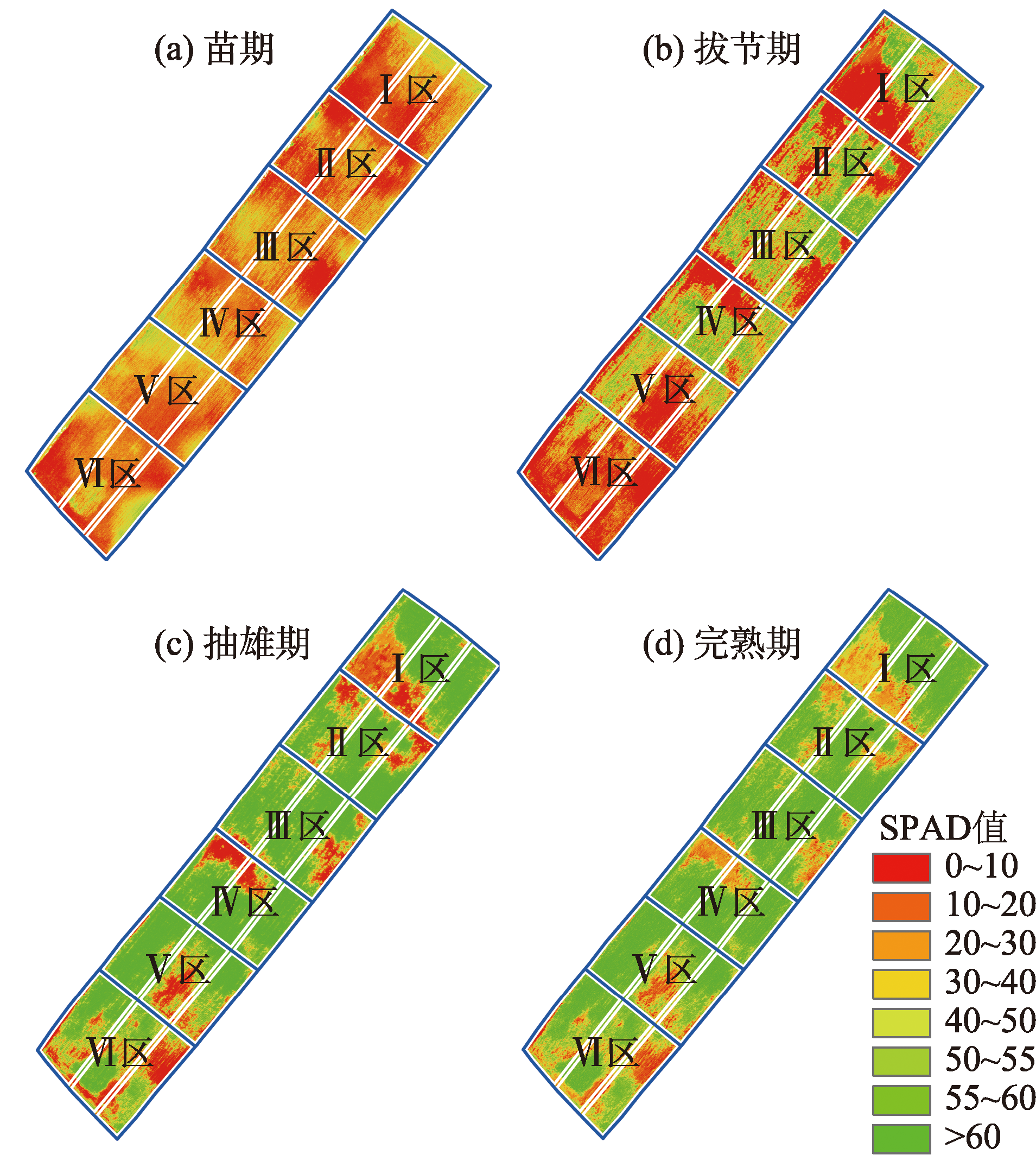
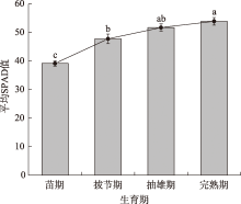
图4
不同生育期平均SPAD值提取结果对比 注:不同小写字母表示不同生育期平均SPAD值差异显著。"


图5
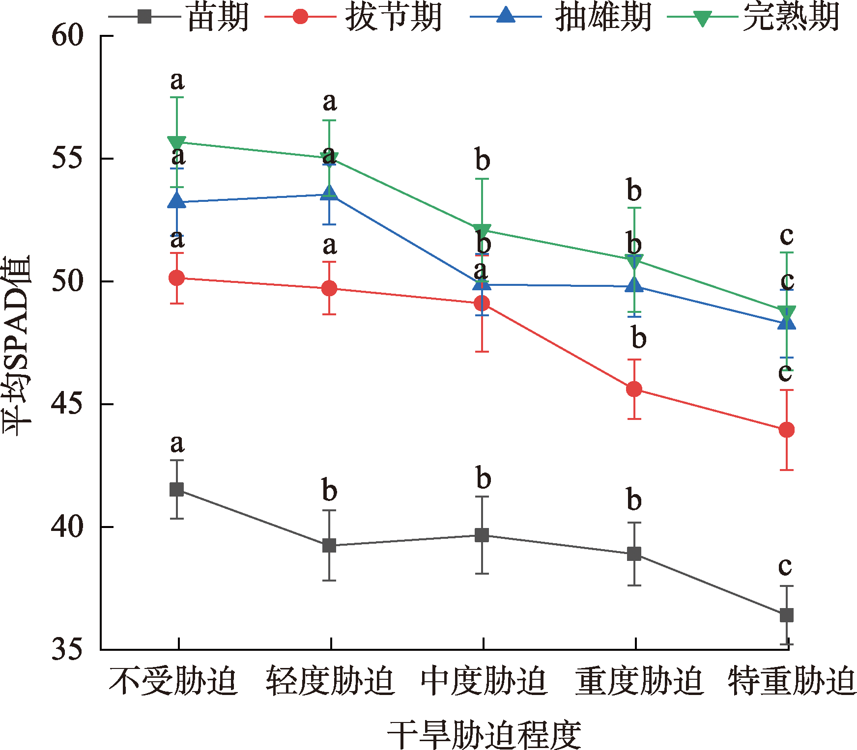
不同程度干旱胁迫下SPAD值提取结果对比 注:不同小写字母表示不同程度干旱胁迫下的SPAD值差异显著。"
| [1] |
Grassini P, Thorburn J, Burr C, et al. High-yield irrigated maize in the western US corn belt: I. On-farm yield, yield potential, and impact of agronomic practices[J]. Field Crops Research, 2011, 120(1): 142-150.
doi: 10.1016/j.fcr.2010.09.012 |
| [2] |
纪伟帅, 陈红艳, 王淑婷, 等. 基于无人机多光谱的华北平原花铃期棉花叶片SPAD建模方法研究[J]. 中国农学通报, 2021, 37(22): 143-150.
doi: 10.11924/j.issn.1000-6850.casb2020-0683 |
|
[Ji Weishuai, Chen Hongyan, Wang Shuting, et al. Modeling method of cotton leaves SPAD at flowering and boll stage in North China Plain based on UAV multi-spectrum[J]. Chinese Agricultural Science Bulletin, 2021, 37(22): 143-150.]
doi: 10.11924/j.issn.1000-6850.casb2020-0683 |
|
| [3] | 陈浩, 冯浩, 杨祯婷, 等. 基于无人机多光谱遥感的夏玉米冠层叶绿素含量估计[J]. 排灌机械工程学报, 2021, 39(6): 622-629. |
| [Chen Hao, Feng Hao, Yang Zhenting, et al. Estimation of chlorophyll content of summer maize canopy based on UAV multispectral remote sensing[J]. Journal of Drainage and Irrigation Machinery, 2021, 39(6): 622-629.] | |
| [4] |
Zhang S M, Zhao G X. A harmonious satellite-unmanned aerial vehicle-ground measurement inversion method for monitoring salinity in coastal saline soil[J]. Remote Sensing, 2019, 11(14): 1700, doi: 10.3390/rs11141700.
doi: 10.3390/rs11141700 |
| [5] | 毛智慧, 邓磊, 孙杰, 等. 无人机多光谱遥感在玉米冠层叶绿素预测中的应用研究[J]. 光谱学与光谱分析, 2018, 38(9): 2923-2931. |
| [Mao Zhihui, Deng Lei, Sun Jie, et al. Research on the application of UAV multispectral remote sensing in the maize chlorophyll prediction[J]. Spectroscopy and Spectral Analysis, 2018, 38(9): 2923-2931.] | |
| [6] | 谭惠芝, 尹倩, 姬莉雯, 等. 融合GPM降水数据的土壤干旱遥感监测[J]. 干旱区研究, 2021, 38(2): 513-525. |
| [Tan Huizhi, Yin Qian, Ji Liwen, et al. Remote sensing monitoring of soil drought in Shenmu City, Shaanxi Province integrating GPM precipitation data[J]. Arid Zone Research, 2021, 38(2): 513-525.] | |
| [7] | 车永飞, 肖策, 王正庆, 等. 基于遥感技术的植物非生物胁迫性研究进展[J]. 南华大学学报(自然科学版), 2020, 34(2): 34-41. |
| [Che Yongfei, Xiao Ce, Wang Zhengqing, et al. Advances in studies on plant abiotic stress based on remote sensing technology[J]. Journal of University of South China (Science and Technology Edition), 2020, 34(2): 34-41.] | |
| [8] | 袁小康, 周广胜, 王秋玲, 等. 不同灌溉量夏玉米叶绿素含量的高光谱特征及其反演[J]. 生态学报, 2021, 41(2): 543-552. |
| [Yuan Xiaokang, Zhou Guangsheng, Wang Qiuling, et al. Hyperspectral characteristics of chlorophyll content in summer maize under different water irrigation conditions and its inversion[J]. Acta Ecologica Sinica, 2021, 41(2): 543-552.] | |
| [9] | Sims D A, Gamon J A. Relationships between leaf pigment content and spectral reflectance across a wide range of species, leaf structures and developmental stages[J]. Remote Sensing of Environment, 2002, 81(2-3): 331-354. |
| [10] |
Wu C, Niu Z, Tang Q, et al. Estimating chlorophyll content from hyperspectral vegetation indices: Modeling and validation[J]. Agricultural and Forest Meteorology, 2008, 148(8-9): 1230-1241.
doi: 10.1016/j.agrformet.2008.03.005 |
| [11] |
姜海玲, 杨杭, 陈小平, 等. 利用光谱指数反演植被叶绿素含量的精度及稳定性研究[J]. 光谱学与光谱分析, 2015, 35(4): 975-981.
pmid: 26197586 |
|
[Jiang Hailing, Yang Hang, Chen Xiaoping, et al. Research on accuracy and stability of inversing vegetation chorophyll content by spectral index method[J]. Spectroscopy and Spectral Analysis, 2015, 35(4): 975-981.]
pmid: 26197586 |
|
| [12] | 白莉萍, 隋方功, 孙朝晖, 等. 土壤水分胁迫对玉米形态发育及产量的影响[J]. 生态学报, 2004, 24(7): 1556-1560. |
| [Bai Liping, Sui Fanggong, Sun Zhaohui, et al. Effects of soil water stress on morphological development and yield of maize[J]. Acta Ecologica Sinica, 2004, 24(7): 1556-1560.] | |
| [13] |
McDowell N, Pockman W T, Allen C D, et al. Mechanisms of plant survival and mortality during drought: Why do some plants survive while others succumb to drought?[J]. New Phytologist, 2008, 178(4): 719-739.
doi: 10.1111/j.1469-8137.2008.02436.x pmid: 18422905 |
| [14] | 易秋香, 黄敬峰, 王秀珍, 等. 玉米叶绿素高光谱遥感估算模型研究[J]. 科技通报, 2007, 23(1): 83-87. |
| [Yi Qiuxiang, Huang Jingfeng, Wang Xiuzhen, et al. Hyperspectral remote sensing estimation models for chlorophyll concentration in corn[J]. Bulletin of Science and Technology, 2007, 23(1): 83-87.] | |
| [15] |
王宏博, 冯锐, 纪瑞鹏, 等. 干旱胁迫下春玉米拔节-吐丝期高光谱特征[J]. 光谱学与光谱分析, 2012, 32(12): 3358-3362.
pmid: 23427567 |
|
[Wang Hongbo, Feng Rui, Ji Ruipeng, et al. Hyperspectral characteristics of spring maize from jointing to silking stage under drought stress[J]. Spectroscopy and Spectral Analysis, 2012, 32(12): 3358-3362.]
pmid: 23427567 |
|
| [16] | 武倩雯, 熊黑钢, 王凯龙, 等. 干旱区玉米抽雄期叶绿素含量高光谱最佳模型选择[J]. 干旱地区农业研究, 2015, 33(2): 81-86. |
| [Wu Qianwen, Xiong Heigang, Wang Kailong, et al. Selection of optimal model using hyperspectral parameters for chlorophyll content of maize during tasseling stage in arid region[J]. Agricultural Research in the Arid Areas, 2015, 33(2): 81-86.] | |
| [17] | 黄木易, 王纪华, 黄文江, 等. 冬小麦条锈病的光谱特征及遥感监测[J]. 农业工程学报, 2003, 19(6): 154-158. |
| [Huang Muyi, Wang Jihua, Huang Wenjiang, et al. Hyperspectral character of stripe rust on winter wheat and monitoring by remote sensing[J]. Transactions of the Chinese Society of Agricultural Engineering, 2003, 19(6): 154-158.] | |
| [18] | 杜雅仙, 黄菊莹, 康扬眉, 等. 脱硫石膏与结构改良剂配合施用对龟裂碱土理化性状和水稻生长的影响[J]. 水土保持通报, 2018, 38(5): 46-51. |
| [Du Yaxian, Huang Juying, Kang Yangmei, et al. Effect of desulfurized gypsum and structure amendment application on soil physical and chemical properties of takyr solonetz soil and rice growth[J]. Bulletin of Soil and Water Conservation, 2018, 38(5): 46-51.] | |
| [19] | NY/T 2284-2012. 中华人民共和国农业行业标准: 玉米灾害田间调查及分级技术规范[S]. 北京: 高等教育出版社, 2013. |
| [NY/T 2284-2012. Agricultural industry standard of the People’s Republic of China: Technical specification for field investigation and classification of maize disasters[S]. Beijing: Higher Education Press, 2013.] | |
| [20] |
Zarco-Tejada P J, Miller J R, Morales A, et al. Hyperspectral indices and model simulation for chlorophyll estimation in open-canopy tree crops[J]. Remote Sensing of Environment, 2004, 90(4): 463-476.
doi: 10.1016/j.rse.2004.01.017 |
| [21] |
Delegido J, Verrelst J, Alonso L, et al. Evaluation of Sentinel-2 red-edge bands for empirical estimation of green LAI and chlorophyll content[J]. Sensors, 2011, 11(7): 7063-7081.
doi: 10.3390/s110707063 pmid: 22164004 |
| [22] |
Rondeaux G, Steven M, Baret F. Optimization of soil-adjusted vegetation indices[J]. Remote Sensing of Environment, 1996, 55(2): 95-107.
doi: 10.1016/0034-4257(95)00186-7 |
| [23] |
Cao Q, Miao Y X, Shen J N, et al. Improving in-season estimation of rice yield potential and responsiveness to topdressing nitrogen application with crop circle active crop canopy sensor[J]. Precision Agriculture, 2016, 17(2): 136-154.
doi: 10.1007/s11119-015-9412-y |
| [24] | 牛庆林, 冯海宽, 周新国, 等. 冬小麦SPAD值无人机可见光和多光谱植被指数结合估算[J]. 农业机械学报, 2021, 52(8): 183-194. |
| [Niu Qinglin, Feng Haikuan, Zhou Xinguo, et al. Combining UAV visible light and multispectral vegetation indices for estimating SPAD value of winter wheat[J]. Transactions of the Chinese Society for Agricultural Machinery, 2021, 52(8): 183-194.] | |
| [25] | 陈红艳, 赵庚星, 陈敬春, 等. 基于改进植被指数的黄河口区盐渍土盐分遥感反演[J]. 农业工程学报, 2015, 31(5): 107-112. |
| [Chen Hongyan, Zhao Gengxing, Chen Jingchun, et al. Remote sensing inversion of saline soil salinity based on modified vegetation index in estuary area of Yellow River[J]. Transactions of the Chinese Society of Agricultural Engineering, 2015, 31(5): 107-112.] | |
| [26] | 范迎迎, 钱育蓉, 杨柳, 等. 基于BP神经网络的遥感影像棉花识别方法[J]. 计算机工程与设计, 2017, 38(5): 1356-1360. |
| [Fan Yingying, Qian Yurong, Yang Liu, et al. Cotton recognition method for remote sensing image based on BP neural network[J]. Computer Engineering and Design, 2017, 38(5): 1356-1360.] | |
| [27] | 何桂芳, 吴见, 彭建, 等. 基于高光谱的石楠叶片叶绿素含量估算模型[J]. 西北林学院学报, 2022, 37(1): 25-32. |
| [He Guifang, Wu Jian, Peng Jian, et al. Estimation models of chlorophyll contents in Photinia serrulata leaves based on hyperspectral data[J]. Journal of Northwest Forestry University, 2022, 37(1): 25-32.] | |
| [28] | 傅佳丽. 平潭海岛土壤元素的高光谱遥感反演模型[D]. 福州: 福建师范大学, 2016. |
| [Fu Jiali. Modeling island soil elements with visible near infrared reflectance spectroscopy in Pingtan[D]. Fuzhou: Fujian Normal University, 2016.] | |
| [29] |
刘畅, 孙鹏森, 刘世荣. 植物反射光谱对水分生理变化响应的研究进展[J]. 植物生态学报, 2016, 40(1): 80-91.
doi: 10.17521/cjpe.2015.0267 |
|
[Liu Chang, Sun Pengsen, Liu Shirong. A review of plant spectral reflectance response to water physiological changes[J]. Chinese Journal of Plant Ecology, 2016, 40(1): 80-91.]
doi: 10.17521/cjpe.2015.0267 |
|
| [30] | 周敏姑, 邵国敏, 张立元, 等. 无人机多光谱遥感反演冬小麦SPAD值[J]. 农业工程学报, 2020, 36(20): 125-133. |
| [Zhou Mingu, Shao Guomin, Zhang Liyuan, et al. Inversion of SPAD value of winter wheat by multispectral remote sensing of unmanned aerial vehicles[J]. Transactions of the Chinese Society of Agricultural Engineering, 2020, 36(20): 125-133.] | |
| [31] |
Mulla D J. Twenty five years of remote sensing in precision agriculture: Key advances and remaining knowledge gaps[J]. Biosystems Engineering, 2013, 114(4): 358-371.
doi: 10.1016/j.biosystemseng.2012.08.009 |
| [32] | 史博太. 关中地区冬小麦叶绿素含量遥感反演研究[D]. 咸阳: 西北农林科技大学, 2021. |
| [Shi Botai. Study on remote sensing retrieval of chlorophyll content of winter wheat in Guanzhong area[D]. Xianyang: Northwest A & F University, 2021.] | |
| [33] |
Jacquemoud S, Baret F. Prospect: A model of leaf optical properties spectra[J]. Remote Sensing of Environment, 1990, 34(2): 75-91.
doi: 10.1016/0034-4257(90)90100-Z |
| [34] | 宫兆宁, 赵雅莉, 赵文吉, 等. 基于光谱指数的植物叶片叶绿素含量的估算模型[J]. 生态学报, 2014, 34(20): 5736-5745. |
| [Gong Zhaoning, Zhao Yali, Zhao Wenji, et al. Estimation model for plant leaf chlorophyll content based on the spectral index content[J]. Acta Ecologica Sinica, 2014, 34(20): 5736-5745.] | |
| [35] | 冯文斌. 基于无人机多光谱遥感的夏玉米长势监测及产量估测[D]. 泰安: 山东农业大学, 2022. |
| [Feng Wenbin. Summer corn growth monitoring and yield estimation by UAV-based multispectral remote sensing[D]. Tai’an: Shandong Agricultural University, 2022.] | |
| [36] | 冯浩, 杨祯婷, 陈浩, 等. 基于无人机多光谱影像的夏玉米SPAD估算模型研究[J]. 农业机械学报, 2022, 53(10): 211-219. |
| [Feng Hao, Yang Zhenting, Chen Hao, et al. Estimation of summer maize SPAD based on UAV multispectral images[J]. Transactions of the Chinese Society of Agricultural Machinery, 2022, 53(10): 211-219.] | |
| [37] | 方静. 耐旱春小麦根际微生物对干旱胁迫的响应机制[D]. 呼和浩特: 内蒙古大学, 2021. |
| [Fang Jing. Response mechanism of rhizosphere microorganisms to drought stress in drought-tolerant spring wheat[D]. Hohhot: Inner Mongolia University, 2021.] | |
| [38] | 宋佩鸿, 张广娜, 祝莹莹, 等. 干旱胁迫对鼠茅草生长及生理特性的影响[J]. 草学, 2022(1): 23-29. |
| [Song Peihong, Zhang Guangna, Zhu Yingying, et al. Effects of drought stress on growth and physiological characteristics of Vulpia myuros C. Gmelin.[J]. Journal of Grassland and Forage Science, 2022(1): 23-29.] | |
| [39] | 周永斌. 转W16小麦回交株系基因表达特性及其抗旱机制研究[D]. 咸阳: 西北农林科技大学, 2012. |
| [Zhou Yongbin. The expression of W16 in the backcross lines of transgenic bread wheat and its relation with drought tolerance[D]. Xianyang: Northwest A & F University, 2012.] | |
| [40] | 赵永长. 黄腐酸钾对干旱胁迫下烤烟生长的调控效应及机理研究[D]. 北京: 中国农业科学院, 2017. |
| [Zhao Yongchang. Regulatory effects and its mechanism of fulvic acid potassium on growth of flue-cured tobacco under drought stress[D]. Beijing: Chinese Academy of Agricultural Sciences, 2017.] | |
| [41] | 陈丽君, 魏永霞. 玉米膜下滴灌不同补水处理对其产量的影响[J]. 中国农村水利水电, 2010(6): 85-87. |
| [Chen Lijun, Wei Yongxia. Effects of different irrigation treatments on maize yield with drip irrigation under mulch films[J]. China Rural Water and Hydropower, 2010(6): 85-87.] | |
| [42] | 王慧, 曾路生, 孙永红, 等. 重金属铜和锌胁迫下的小麦冠层反射光谱特征[J]. 农业工程学报, 2017, 33(2): 171-176. |
| [Wang Hui, Zeng Lusheng, Sun Yonghong, et al. Wheat canopy spectral reflectance feature response to heavy metal copper and zinc stress[J]. Transactions of the Chinese Society of Agricultural Engineering, 2017, 33(2): 171-176.] | |
| [43] | 乌日娜, 张兴东, 王妍, 等. 3种优势牧草在不同生育期对干旱胁迫的响应[J]. 草业科学, 2021, 38(11): 2210-2220. |
| [Wu Rina, Zhang Xingdong, Wang Yan, et al. Response of three dominant forages to drought stress at different growth stages[J]. Pratacultural Science, 2021, 38(11): 2210-2220.] | |
| [44] | 刘爽, 于海业, 张郡赫, 等. 基于最优光谱指数的大豆叶片叶绿素含量反演模型研究[J]. 光谱学与光谱分析, 2021, 41(6): 1912-1919. |
| [Liu Shuang, Yu Haiye, Zhang Junhe, et al. Study on inversion model of chlorophyll content in soybean leaf based on optimal spectral indices[J]. Spectroscopy and Spectral Analysis, 2021, 41(6): 1912-1919.] | |
| [45] | 李媛媛, 常庆瑞, 刘秀英, 等. 基于高光谱和BP神经网络的玉米叶片SPAD值遥感估算[J]. 农业工程学报, 2016, 32(16): 135-142. |
| [Li Yuanyuan, Chang Qingrui, Liu Xiuying, et al. Estimation of maize leaf SPAD value based on hyperspectrum and BP neural network[J]. Transactions of the Chinese Society of Agricultural Engineering, 2016, 32(16): 135-142.] | |
| [46] | 毛博慧, 李民赞, 孙红, 等. 冬小麦苗期叶绿素含量检测光谱学参数寻优[J]. 农业工程学报, 2017, 33(增刊1): 164-169. |
| [Mao Bohui, Li Minzan, Sun Hong, et al. Optimization of spectroscopy parameters and prediction of chlorophyll content at seeding stage of winter wheat[J]. Transactions of the Chinese Society of Agricultural Engineering, 2017, 33(Suppl. 1): 164-169.] | |
| [47] | 陈振, 隋学艳, 梁守真, 等. 拔节期夏玉米洪涝胁迫下叶绿素含量和高光谱特征变化[J]. 江苏农业科学, 2017, 45(2): 69-72. |
| [Chen Zhen, Sui Xueyan, Liang Shouzhen, et al. Changes of chlorophyll content and hyperspectral characteristics of summer maize under flood stress at jointing stage[J]. Jiangsu Agricultural Sciences, 2017, 45(2): 69-72.] | |
| [48] | 田明璐, 班松涛, 常庆瑞, 等. 基于无人机成像光谱仪数据的棉花叶绿素含量反演[J]. 农业机械学报, 2016, 47(11): 285-293. |
| [Tian Minglu, Ban Songtao, Chang Qingrui, et al. Estimation of SPAD value of cotton leaf using hyperspectral images from UAV-based imaging spectroradiometer[J]. Transactions of the Chinese Society for Agricultural Machinery, 2016, 47(11): 285-293.] | |
| [49] | 周林寰. 一类支持向量机在线算法及其应用[D]. 大连: 大连理工大学, 2021. |
| [Zhou Linhuan. A class of online algorithms for support vector machine and their application[D]. Dalian: Dalian University of Technology, 2021.] | |
| [50] | 彭晓伟, 张爱军, 杨晓楠, 等. 谷子叶绿素含量高光谱特征分析及其反演模型构建[J]. 干旱地区农业研究, 2022, 40(2): 69-77. |
| [Peng Xiaowei, Zhang Aijun, Yang Xiaonan, et al. Hyperspectral characteristics and remote sensing inversion model of chlorophyll content of millet[J]. Agricultural Research in the Arid Areas, 2022, 40(2): 69-77.] |
| [1] | 朱磊, 王科, 丁一民, 孙振源, 孙伯颜. 基于Sentinel-2的青铜峡灌区水稻和玉米种植分布早期识别[J]. 干旱区地理, 2024, 47(5): 850-860. |
| [2] | 高彦婷, 张芮, 董博, 李青青, 刘柯含. 垄沟覆盖集雨模式对玉米根际土壤微生物多样性的影响[J]. 干旱区地理, 2024, 47(3): 413-423. |
| [3] | 刘焕才,史书琦,李曼,张艳芳,韩丽. 疏勒河流域中游地区玉米性状及单产的影响因子研究[J]. 干旱区地理, 2023, 46(9): 1453-1466. |
| [4] | 姜磊鹏,丁建丽,包青岭,葛翔宇,刘景明,王瑾杰. 低空遥感结合卫星影像的河道流量反演[J]. 干旱区地理, 2023, 46(3): 385-396. |
| [5] | 刘旭辉,白云岗,柴仲平,张江辉,丁邦新,江柱. 基于多光谱遥感的典型绿洲棉田春季土壤盐分反演及验证[J]. 干旱区地理, 2022, 45(4): 1165-1175. |
| [6] | 杨雪峰,昝梅,木尼热·买买提. 基于无人机的胡杨(Populus euphratica)结构参数获取技术研究[J]. 干旱区地理, 2021, 44(2): 441-449. |
| [7] | 张明远, 张登山, 吴汪洋, 田丽慧, 周鑫. 无人机影像三维重建在沙丘形态监测中的应用[J]. 干旱区地理, 2018, 41(6): 1341-1350. |
| [8] | 杨肖, 钟方雷, 郭爱君. 绿洲农户生产效率差异评价及改进策略——以张掖市制种玉米为例[J]. 干旱区地理, 2017, 40(4): 913-919. |
| [9] | 李均力, 陈曦, 包安明, 沈占锋, 季顺平. 公格尔九别峰冰川跃动无人机灾害监测与评估[J]. 干旱区地理, 2016, 39(2): 378-386. |
| Viewed | ||||||||||||||||||||||||||||||||||||||||||||||||||
|
Full text 3260
|
|
|||||||||||||||||||||||||||||||||||||||||||||||||
|
Abstract 477
|
|
|||||||||||||||||||||||||||||||||||||||||||||||||
Cited |
|
|||||||||||||||||||||||||||||||||||||||||||||||||
| Shared | ||||||||||||||||||||||||||||||||||||||||||||||||||
|
||