- 2025年8月13日 星期三
干旱区地理 ›› 2021, Vol. 44 ›› Issue (1): 208-220.doi: 10.12118/j.issn.1000–6060.2021.01.22
程浩然1( ),蒙吉军1(),朱利凯2
收稿日期:2020-05-10
修回日期:2020-10-25
出版日期:2021-01-25
发布日期:2021-03-09
通讯作者:
蒙吉军
作者简介:程浩然(1996-),男,硕士研究生,主要研究方向为土地多功能利用. E-mail: 基金资助:
CHENG Haoran1(),MENG Jijun1(),ZHU Likai2
Received:2020-05-10
Revised:2020-10-25
Online:2021-01-25
Published:2021-03-09
Contact:
Jijun MENG
摘要:
土地多功能利用是提高土地利用效率、缓解人地矛盾、促进区域可持续发展的重要途径。研究构建了“生产-生活-生态”功能的土地多功能性评价指标体系,基于3 km×3 km格网,融合了遥感、统计、POI等多源地理数据,利用投影寻踪模型对黑河中游土地多功能性进行评价,通过变量相关分析和双变量局部空间自相关分析,揭示了土地多功能权衡与协同关系,并采用RGB三通道合成与二阶聚类分析相结合进行土地功能分区。结果表明:(1) 黑河中游在不同利用方式下呈现不同功能,在走廊平原区土地功能以生产功能为主导,生活功能和生态功能为辅。生产功能在走廊绿洲农业区优势明显,生活功能高值区集中于城镇等基础设施条件较好的地区,祁连山、龙首山发挥着生态屏障作用。(2) 研究时段内,土地多功能性稳中增强。土地多功能性与一级功能的空间格局保持稳定,土地功能间协调性普遍增强,不同功能在空间上日益重叠。(3) 按照主导利用方向,土地可划分为以农业生产与城镇空间为主体的重点开发区、优化开发区和适度开发区,以及以生态空间为主的生态屏障区、生态缓冲区和生态修复区。(4) 土地多功能利用仍有提升空间,尤其要加强对非主导功能的关注,协调功能间的固有矛盾;统筹推进生态修复,关注自然资本增值,从构建区域绿水青山的格局挖掘土地价值新的增长点。
程浩然,蒙吉军,朱利凯. 基于多源地理数据融合的黑河中游土地多功能性时空格局与权衡研究[J]. 干旱区地理, 2021, 44(1): 208-220.
CHENG Haoran,MENG Jijun,ZHU Likai. Spatial-temporal pattern and trade-offs of land multi-function in the middle reaches of the Heihe River based on multi-source geographic data fussion[J]. Arid Land Geography, 2021, 44(1): 208-220.

图1
黑河中游区位概况"
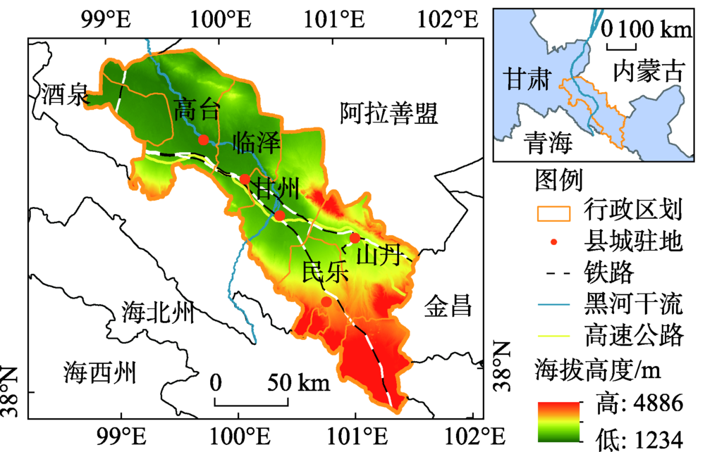
表1
黑河中游土地多功能性评价指标体系"
| 目标层 | 准则层 | 指标层(作用方向) | 数据层 | 2013年权重 | 2016年权重 |
|---|---|---|---|---|---|
| 生产功能 | 农业生产 | 第一产业增加值X1 (+) | 第一产业增加值总额/104元 | 0.1383 | 0.1526 |
| 猪牛羊肉产量X2 (+) | 猪牛羊肉总产量/104 kg | 0.0651 | 0.0690 | ||
| 有效灌溉面积X3 (+) | 有效灌溉面积/hm2 | 0.1526 | 0.1592 | ||
| 经济生产 | 第二三产业增加值X4 (+) | 第二三产业增加值总额/104元 | 0.0785 | 0.0703 | |
| 交通运输 | 交通设施密度X5 (+) | 百度地图交通设施POI | 0.1563 | 0.1739 | |
| 生活功能 | 就业支持 | 城镇居民可支配收入X6 (+) | 城镇居民可支配收入总额/元 | 0.0505 | 0.0613 |
| 农村居民可支配收入X7 (+) | 农村居民可支配收入总额/元 | 0.0697 | 0.0528 | ||
| 第二三产业从业人员规模X8 (+) | 第二三产业从业人员总数/人 | 0.0301 | 0.0524 | ||
| 居住家园 | 生活设施密度X9 (+) | 百度地图生活设施POI | 0.0632 | 0.0626 | |
| 自来水受益户数比X10 (+) | 自来水受益户数/总户数 | 0.0532 | 0.0668 | ||
| 健康保障 | 医疗设施密度X11 (+) | 百度地图医疗设施POI | 0.0507 | 0.0215 | |
| 生态功能 | 生态维持 | 土壤侵蚀强度X12 (-) | 土壤侵蚀强度 | 0.0235 | 0.0197 |
| 林地面积比例X13 (+) | 林地面积/土地总面积 | 0.0365 | 0.0226 | ||
| 减轻污染 | 化肥施用强度X14 (-) | 化肥施用实物量/t | 0.0318 | 0.0154 |

图2
黑河中游交通设施、生活设施和医疗设施空间化处理结果"
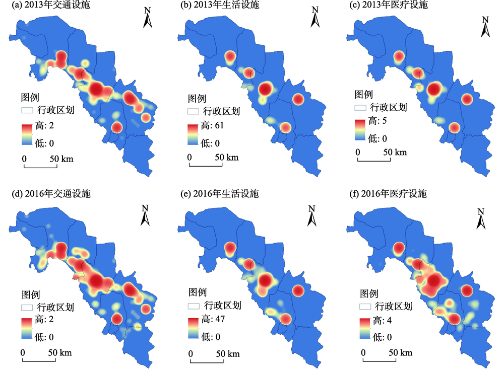

图3
黑河中游土地多功能性组成和等级结构"
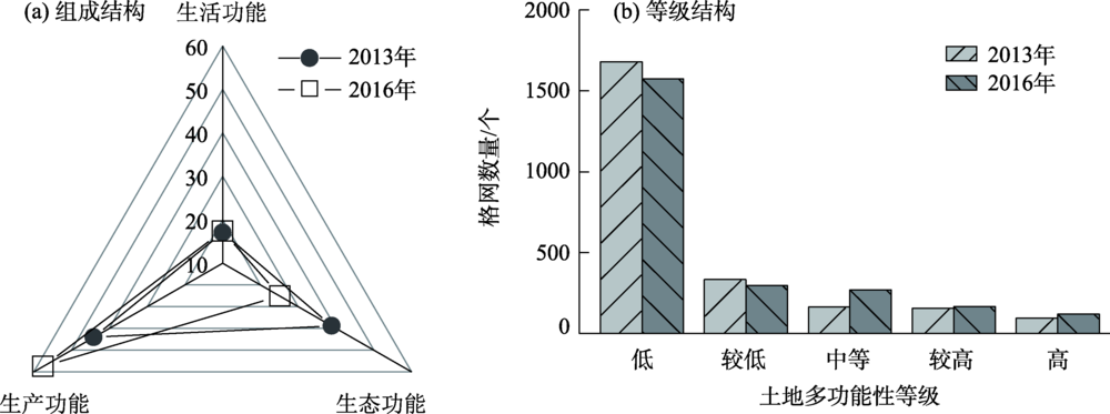
表2
自然断裂法分级阈值"
| 年份 | 低 | 较低 | 中等 | 较高 | 高 |
|---|---|---|---|---|---|
| 2013 | 0.3248 | 0.5959 | 0.9710 | 1.4776 | 2.3398 |
| 2016 | 0.2510 | 0.5165 | 0.8753 | 1.3148 | 1.9034 |

图4
黑河中游2013和2016年土地多功能性综合得分及冷热点分布"
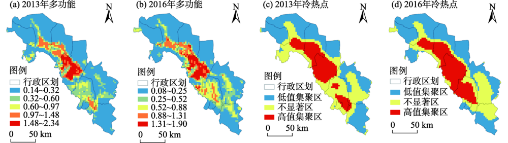

图5
黑河中游2013和2016年土地生产功能评价结果及冷热点分布"
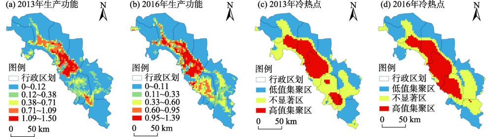
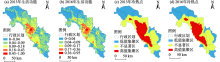
图6
黑河中游2013和2016年土地生活功能评价结果及冷热点分布"


图7
黑河中游2013和2016年土地生态功能评价结果及冷热点分布"
表3
黑河中游土地一级功能间Spearman相关系数"
| 2013年 | 2016年 | ||
|---|---|---|---|
| 生产功能 | 生活功能 | 生态功能 | |
| 生产功能 | - | 0.647** | -0.123** |
| 生活功能 | 0.565** | - | -0.241** |
| 生态功能 | -0.053** | -0.221** | - |
表4
黑河中游土地二级功能间Spearman相关系数"
| 2013年 | 2016年 | ||||||||||
|---|---|---|---|---|---|---|---|---|---|---|---|
| 生产功能 | 生活功能 | 生态功能 | |||||||||
| 农业生产 | 经济生产 | 交通运输 | 居住家园 | 就业支持 | 健康保障 | 生态维持 | 减轻污染 | ||||
| 生产功能 | 农业生产 | - | 0.466** | 0.611** | 0.606** | 0.623** | 0.695** | 0.338** | -0.907** | ||
| 经济生产 | 0.446** | - | 0.555** | 0.466** | 0.421** | 0.524** | 0.056** | -0.418** | |||
| 交通运输 | 0.481** | 0.526** | - | 0.564** | 0.518** | 0.797** | 0.033 | -0.626** | |||
| 生活功能 | 居住家园 | 0.520** | 0.480** | 0.504** | - | 0.964** | 0.695** | 0.031 | -0.564** | ||
| 就业支持 | 0.542** | 0.429** | 0.477** | 0.970** | - | 0.643** | 0.072** | -0.559** | |||
| 健康保障 | 0.555** | 0.549** | 0.748** | 0.569** | 0.539** | - | 0.108** | -0.698** | |||
| 生态功能 | 生态维持 | 0.388** | 0.052* | 0.013 | 0.043* | 0.075** | 0.109** | - | -0.256** | ||
| 减轻污染 | -0.964** | -0.429** | -0.496** | -0.504** | -0.524** | -0.569** | -0.316** | - | |||

图8
黑河中游土地一级功能间双变量LISA聚类图"
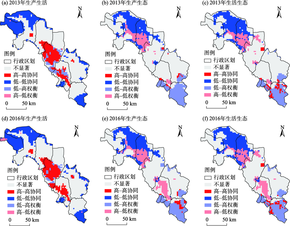
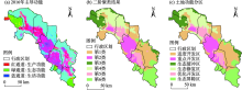
图9
黑河中游土地主导功能、二阶聚类结果与土地功能分区"

| [1] | 蒙吉军. 土地评价与管理[M]. 3版. 北京: 科学出版社, 2019. |
| [ Meng Jijun. Land evaluation and management [M]. 3rd ed. Beijing: Science Press, 2019. ] | |
| [2] |
Verburg P H, van de Steeg J, Veldkamp A, et al. From land cover change to land function dynamics: A major challenge to improve land characterization[J]. Journal of Environmental Management, 2009,90(3):1327-1335.
doi: 10.1016/j.jenvman.2008.08.005 pmid: 18809242 |
| [3] |
Foley J A, Ramankutty N, Brauman K A, et al. Solutions for a cultivated planet[J]. Nature, 2011,478(7369):337-342.
doi: 10.1038/nature10452 pmid: 21993620 |
| [4] | 王枫, 董玉祥. 基于灰色关联投影法的土地利用多功能动态评价及障碍因子诊断——以广州市为例[J]. 自然资源学报, 2015,30(10):1698-1713. |
| [ Wang Feng, Dong Yuxiang. Dynamic evaluation of land use functions based on grey relation projection method and diagnosis of its obstacle indicators: A case study of Guangzhou City[J]. Journal of Natural Resources, 2015,30(10):1698-1713. ] | |
| [5] | 张晓平, 朱道林, 许祖学. 西藏土地利用多功能性评价[J]. 农业工程学报, 2014,30(6):185-194. |
| [ Zhang Xiaoping, Zhu Daolin, Xu Zuxue. Assessment on multi-functionality of land use in Tibet[J]. Transactions of the Chinese Society of Agricultural Engineering, 2014,30(6):185-194. ] | |
| [6] | 朱琳, 黎磊, 刘素, 等. 大城市郊区村域土地利用功能演变及其对乡村振兴的启示——以成都市江家堰村为例[J]. 地理研究, 2019,38(3):535-549. |
| [ Zhu Lin, Li Lei, Liu Su, et al. The evolution of village land-use function in the metropolitan suburbs and its inspiration to rural revitalization: A case study of Jiangjiayan Village in Chengdu City[J]. Geographical Research, 2019,38(3):535-549. ] | |
| [7] | Mander Ü, Helming K, Wiggering H. Multifunctional land use: Meeting future demands for landscape goods and services[M]. Berlin, Heidelberg: Springer, 2007. |
| [8] | 甄霖, 曹淑艳, 魏云洁, 等. 土地空间多功能利用: 理论框架及实证研究[J]. 资源科学, 2009,31(4):544-551. |
| [ Zhen Lin, Cao Shuyan, Wei Yunjie, et al. Land use functions: Conceptual framework and application for China[J]. Resources Science, 2009,31(4):544-551. ] | |
| [9] | OECD. Multifunctionality: Towards an analytical framework[M]. Paris: Organization for Economic Co-operation and Development (OECD), 2001. |
| [10] |
Paracchini M L, Pacini C, Jones M L M, et al. An aggregation framework to link indicators associated with multifunctional land use to the stakeholder evaluation of policy options[J]. Ecological Indicators, 2011,11(1):71-80.
doi: 10.1016/j.ecolind.2009.04.006 |
| [11] | Pérez-Soba M, Petit S, Jones L, et al. Land use functions: A multifunctionality approach to assess the impact of land use changes on land use sustainability [C]//Helming K, Pérez-Soba M, Tabbush P. Sustainability Impact Assessment of Land Use Changes. Berlin, Heidelberg: Springer, 2008: 375-404. |
| [12] | 甄霖, 魏云洁, 谢高地, 等. 中国土地利用多功能性动态的区域分析[J]. 生态学报, 2010,30(24):6749-6761. |
| [ Zhen Lin, Wei Yunjie, Xie Gaodi, et al. Regional analysis of dynamic land use functions in China[J]. Acta Ecologica Sinica, 2010,30(24):6749-6761. ] | |
| [13] | 郭欢欢, 李波, 侯鹰. 基于土地功能的土地资源承载力研究——以北京市海淀区为例[J]. 北京师范大学学报(自然科学版), 2011,47(4):424-427. |
| [ Guo Huanhuan, Li Bo, Hou Ying. Research on the capacity of land resources based on land function: Haidian as an example[J]. Journal of Beijing Normal University(Natural Science), 2011,47(4):424-427. ] | |
| [14] |
范业婷, 金晓斌, 项晓敏, 等. 苏南地区耕地多功能评价与空间特征分析[J]. 资源科学, 2018,40(5):980-992.
doi: 10.18402/resci.2018.05.11 |
|
[ Fan Yeting, Jin Xiaobin, Xiang Xiaomin, et al. Evaluation and spatial characteristics of arable land multifunction in southern Jiangsu[J]. Resources Science, 2018,40(5):980-992. ]
doi: 10.18402/resci.2018.05.11 |
|
| [15] |
戴尔阜, 王晓莉, 朱建佳, 等. 生态系统服务权衡: 方法、模型与研究框架[J]. 地理研究, 2016,35(6):1005-1016.
doi: 10.11821/dlyj201606001 |
|
[ Dai Erfu, Wang Xiaoli, Zhu Jianjia, et al. Methods, tools and research framework of ecosystem service trade-offs[J]. Geographical Research, 2016,35(6):1005-1016. ]
doi: 10.11821/dlyj201606001 |
|
| [16] |
Barbier E B, Koch E W, Silliman B R, et al. Coastal ecosystem-based management with nonlinear ecological functions and values[J]. Science, 2008,319(5861):321-323.
doi: 10.1126/science.1150349 pmid: 18202288 |
| [17] |
钱彩云, 巩杰, 张金茜, 等. 甘肃白龙江流域生态系统服务变化及权衡与协同关系[J]. 地理学报, 2018,73(5):868-879.
doi: 10.11821/dlxb201805007 |
|
[ Qian Caiyun, Gong Jie, Zhang Jinxi, et al. Change and tradeoffs-synergies analysis on watershed ecosystem services: A case study of Bailongjiang Watershed, Gansu[J]. Acta Geographica Sinica, 2018,73(5):868-879. ]
doi: 10.11821/dlxb201805007 |
|
| [18] | Wu J. Landscape sustainability science: Ecosystem services and human well-being in changing landscapes[J]. Landscape Ecology, 2013,28(6):999-1023. |
| [19] | Bai Y, Zhuang C, Ouyang Z Y, et al. Spatial characteristics between biodiversity and ecosystem services in a human-dominated watershed[J]. Ecological Complexity, 2011,8(2):177-183. |
| [20] | 朱庆莹, 胡伟艳, 赵志尚. 耕地多功能权衡与协同时空格局的动态分析——以湖北省为例[J]. 经济地理, 2018,38(7):143-153. |
| [ Zhu Qingying, Hu Weiyan, Zhao Zhishang. Dynamic analysis on spatial-temporal pattern of trade-offs and synergies of multifunctional cultivated land: Evidence from Hubei Province[J]. Economic Geography, 2018,38(7):143-153. ] | |
| [21] | 王川, 刘春芳, 乌亚汗, 等. 黄土丘陵区生态系统服务空间格局及权衡与协同关系——以榆中县为例[J]. 生态学杂志, 2019,38(2):521-531. |
| [ Wang Chuan, Liu Chunfang, Wu Yahan, et al. Spatial pattern, tradeoffs and synergies of ecosystem services in loess hilly region: A case study in Yuzhong County[J]. Chinese Journal of Ecology, 2019,38(2):521-531. ] | |
| [22] |
Egoh B N, Reyers B, Rouget M, et al. Identifying priority areas for ecosystem service management in South African grasslands[J]. Journal of Environmental Management, 2011,92(6):1642-1650.
doi: 10.1016/j.jenvman.2011.01.019 pmid: 21334134 |
| [23] | 李双成, 张才玉, 刘金龙, 等. 生态系统服务权衡与协同研究进展及地理学研究议题[J]. 地理研究, 2013,32(8):1379-1390. |
| [ Li Shuangcheng, Zhang Caiyu, Liu Jinlong, et al. The tradeoffs and synergies of ecosystem services: Research progress, development trend, and themes of geography[J]. Geographical Research, 2013,32(8):1379-1390. ] | |
| [24] | 方莹, 王静, 孔雪松, 等. 耕地利用多功能权衡关系测度与分区优化——以河南省为例[J]. 中国土地科学, 2018,32(11):57-64. |
| [ Fang Ying, Wang Jing, Kong Xuesong, et al. Trade-off relation measurement and zoning optimization of multi-functionality of cultivated land use: A case study of Henan Province[J]. China Land Science, 2018,32(11):57-64. ] | |
| [25] | Zhou D, Xu J, Lin Z. Conflict or coordination? Assessing land use multi-functionalization using production-living-ecology analysis[J]. Science of the Total Environment, 2017,577:136-147. |
| [26] | 王晓君, 石敏俊, 王磊. 黑河中游水资源空间动态优化配置——基于分布式水资源管理模型[C]//中国自然资源学会2011年学术年会论文集(下册). 乌鲁木齐: 中国自然资源学会, 2011: 479-486. |
| [ Wang Xiaojun, Shi Minjun, Wang Lei. Spatial dynamic optimal allocation of water resources in the middle reaches of Heihe River: Based on distributed water resources management model[C]//Proceedings of the 2011 Annual Conference of China Society of Natural Resources (Vol. 2). Urumqi: China Society of Natural Resources, 2011: 479-486. ] | |
| [27] | 杜巧玲, 许学工, 刘文政. 黑河中下游绿洲生态安全评价[J]. 生态学报, 2004,24(9):1916-1923. |
| [ Du Qiaoling, Xu Xuegong, Liu Wenzheng. Ecological security assessment for the oases in the middle and lower Heihe River[J]. Acta Ecologica Sinica, 2004,24(9):1916-1923. ] | |
| [28] | 蒙吉军, 吴秀芹, 李正国. 黑河流域1988—2000年土地利用覆被变化研究[J]. 北京大学学报(自然科学版), 2004,40(6):922-929. |
| [ Meng Jijun, Wu Xiuqin, Li Zhengguo. Land use and land cover changes in Heihe River Basin during the period of 1988—2000[J]. Acta Scientiarum Naturalium Universitatis Pekinensis, 2004,40(6):922-929. ] | |
| [29] | 王祺, 蒙吉军. 黑河中游水资源空间分布对绿洲核心景观类型变化的驱动分析[J]. 北京大学学报(自然科学版), 2016,52(5):919-930. |
| [ Wang Qi, Meng Jijun. Driving analysis of oasis key landscape types changes based on water resource spatial distribution in middle reaches of Heihe Basin[J]. Acta Scientiarum Naturalium Universitatis Pekinensis, 2016,52(5):919-930. ] | |
| [30] | 蒙吉军, 王祺, 李枫, 等. 基于空间差异的黑河中游土地多功能利用研究[J]. 地理研究, 2019,38(2):369-382. |
| [ Meng Jijun, Wang Qi, Li Feng, et al. Assessing multifunctional land use in the middle reach of the Heihe River Basin based on spatial variances[J]. Geographical Research, 2019,38(2):369-382. ] | |
| [31] | 高子轶, 张海峰. 基于POI数据的西宁市零售业空间格局探究[J]. 干旱区地理, 2019,42(5):1195-1204. |
| [ Gao Ziyi, Zhang Haifeng. Spatial structure of the retail industry in Xining City based on POI data[J]. Arid Land Geography, 2019,42(5):1195-1204. ] | |
| [32] | 金菊良, 杨晓华, 丁晶. 基于实数编码的加速遗传算法[J]. 四川大学学报(工程科学版), 2000,32(4):20-24. |
| [ Jin Juliang, Yang Xiaohua, Ding Jing. Real coding based acceleration genetic algorithm[J]. Journal of Sichuan University (Engineering Science Edition), 2000,32(4):20-24. ] | |
| [33] | 彭建, 刘志聪, 刘焱序, 等. 京津冀地区县域耕地景观多功能性评价[J]. 生态学报, 2016,36(8):2274-2285. |
| [ Peng Jian, Liu Zhicong, Liu Yanxu, et al. Assessment of farmland landscape multifunctionality at county level in Beijing-Tianjin-Hebei area[J]. Acta Ecologica Sinica, 2016,36(8):2274-2285. ] | |
| [34] | 詹璇, 林爱文, 孙铖, 等. 武汉市公共交通网络中心性及其与银行网点的空间耦合性研究[J]. 地理科学进展, 2016,35(9):1155-1166. |
| [ Zhan Xuan, Lin Aiwen, Sun Cheng, et al. Centrality of public transportation network and its coupling with bank branches distribution in Wuhan City[J]. Progress in Geography, 2016,35(9):1155-1166. ] | |
| [35] | Anselin L. Local indicators of spatial association: LISA[J]. Geographical Analysis, 1995,27(2):93-115. |
| [36] | Anselin L, Syabri I, Smirnov O. Visualizing multivariate spatial correlation with dynamically linked windows [C]//Anselin L, Rey S. New Tools for Spatial Data Analysis: Proceedings of the Specialist Meeting. Santa Barbara: University of California, 2002. |
| [37] | 徐磊, 董捷, 李璐, 等. 基于功能分区视角的长江中游城市群国土空间特征及优化[J]. 经济地理, 2017,37(6):76-83. |
| [ Xu Lei, Dong Jie, Li Lu, et al. Characteristics and optimization of geographical space in urban agglomeration in the middle reaches of the Yangtze River based on the function zoning[J]. Economic Geography, 2017,37(6):76-83. ] | |
| [38] | 杨发鹏, 张雪唱, 李宗阳. 城市旅游“三生”竞争力空间分异——以西北五省为例[J]. 干旱区地理, 2019,42(3):664-672. |
| [ Yang Fapeng, Zhang Xuechang, Li Zongyang. Spatial differentiation of the “production-life-ecology” competitiveness in urban tourism: A case study of five provinces in northwest China[J]. Arid Land Geography, 2019,42(3):664-672. ] | |
| [39] | 赵领娣, 李莎莎, 赵志博, 等. 干旱半干旱区城市生态效率时空演变及区域差异分析[J]. 干旱区地理, 2020,43(2):449-457. |
| [ Zhao Lingdi, Li Shasha, Zhao Zhibo, et al. Temporal and spatial evolution and regional difference analysis of urban ecological efficiency in arid and semiarid areas[J]. Arid Land Geography, 2020,43(2):449-457. ] | |
| [40] | 白海江. 耕地多功能评价及权衡与协同关系分析——以张掖市为例[J]. 西部大开发(土地开发工程研究), 2020,5(3):1-5. |
| [ Bai Haijiang. Multi-function evaluation and trade-offs and synergy analysis of cultivated land: A case study of Zhangye City[J]. Land Development and Engineering Research, 2020,5(3):1-5. ] |
| [1] | 高福鑫, 赵玲, 魏琼. 乡村非农就业水平的时空格局及动态演进——以青海省为例[J]. 干旱区地理, 2023, 46(12): 2111-2119. |
| [2] | 余玉洋,李晶,周自翔,唐承延. 基于贝叶斯网络的生态系统服务空间格局优化——以泾河流域为例[J]. 干旱区地理, 2022, 45(4): 1268-1280. |
| [3] | 姚旭阳,张明军,张宇,王家鑫,肖涵余. 中国西北地区气候转型的新认识[J]. 干旱区地理, 2022, 45(3): 671-683. |
| [4] | 李雨欣,薛东前,马蓓蓓,董朝阳. 黄土高原地区农村贫困空间演化及偏远特征[J]. 干旱区地理, 2021, 44(2): 534-543. |
| [5] | 马卫, 黄晓燕, 曹小曙. “一带一路”沿线国家开放度时空格局及其影响因素[J]. 干旱区地理, 2020, 43(5): 1358-1370. |
| [6] | 杨晴青, 高岩辉, 杨新军, 吴孔森 . 黄土高原半干旱区微尺度乡村人居环境系统 脆弱性测度及时空分异 ——以陕西省佳县为例[J]. 干旱区地理, 2020, 43(5): 1371-1381. |
| [7] | 刘清, 杨永春, 刘海洋. 中国366个城市空气污染综合程度的时空演变特征分析[J]. 干旱区地理, 2020, 43(3): 820-830. |
| [8] | 童志辉, 熊助国, 孙睿, 刘向铜, 王东东. 利用多源数据估算黑河流域总初级生产力 [J]. 干旱区地理, 2020, 43(2): 440-448. |
| [9] | 孙天瑶, 李雪梅, 许民, 张萌生. 2000—2018年塔里木河流域植被覆盖时空格局 [J]. 干旱区地理, 2020, 43(2): 415-424. |
| [10] | 孟鸿飞, 张明军, 王圣杰, 邱雪, 杜铭霞, 张亚宁, 余秀秀, 周苏娥. 黑河中游夏季昼夜水汽同位素特征及水汽来源分析 [J]. 干旱区地理, 2020, 43(2): 360-370. |
| [11] | 陈曦, 常存, 包安明, 吴世新, 罗格平. 改革开放40 a来新疆土地覆被变化的空间格局与特征[J]. 干旱区地理, 2020, 43(1): 1-11. |
| [12] | 钟佳利, 杨德刚, 霍金炜. 乌昌地区基本公共服务失配度时空格局演化及影响因素分析[J]. 干旱区地理, 2019, 42(5): 1205-1212. |
| [13] | 王彦霞, 王培安. 新型城镇化视角下县域城镇化时空格局及聚集特征——以浙江省为例[J]. 干旱区地理, 2019, 42(2): 423-432. |
| [14] | 李鸿伟, 赵锐锋, 王福红. 人类土地利用干扰对黑河中游湿地时空变化的影响[J]. 干旱区地理, 2018, 41(2): 375-383. |
| [15] | 方创琳, 何伦志, 王岩. 丝绸之路经济带中国-哈萨克斯坦国际合作示范区建设的战略思路与重点[J]. 干旱区地理, 2016, 39(5): 925-934. |
| Viewed | ||||||||||||||||||||||||||||||||||||||||||||||||||
|
Full text 909
|
|
|||||||||||||||||||||||||||||||||||||||||||||||||
|
Abstract 435
|
|
|||||||||||||||||||||||||||||||||||||||||||||||||
Cited |
|
|||||||||||||||||||||||||||||||||||||||||||||||||
| Shared | ||||||||||||||||||||||||||||||||||||||||||||||||||
|
||