干旱区地理 ›› 2026, Vol. 49 ›› Issue (4): 791-803.doi: 10.12118/j.issn.1000-6060.2025.244 cstr: 32274.14.ALG2025244
安佳乐1,2( ), 王蕾1,3, 郑江华1,2(), 李建豪1,2, 赵国兵1,2, 尼格拉·吐尔逊1,2, 伏蓉1,2, 罗磊3
收稿日期:2025-05-06
修回日期:2025-05-26
出版日期:2026-04-25
发布日期:2026-04-28
通讯作者:
郑江华(1973-),男,博士,教授,主要从事干旱区灾害监测、预警与损失评估建模等方面的研究. E-mail: zheng.jianghua@xju.edu.cn作者简介:安佳乐(2000-),男,硕士研究生,主要从事深度学习与野火监测等方面的研究. E-mail: anjiale@stu.xju.edu.cn
基金资助:
AN Jiale1,2(), WANG Lei1,3, ZHENG Jianghua1,2(), LI Jianhao1,2, ZHAO Guobing1,2, Nigela TUERXUN1,2, FU Rong1,2, LUO Lei3
Received:2025-05-06
Revised:2025-05-26
Published:2026-04-25
Online:2026-04-28
摘要:
在全球气候变暖加剧的背景下,极端高温事件频发,导致干旱加剧和可燃物积累,显著提升了野火发生的风险。日益频繁的野火对生态安全与可持续发展构成严重威胁。目前,火烧迹地识别方法主要依赖单一光谱特征,易受植被物候、地形及大气条件干扰,存在误判和漏判问题。为此,提出通过多特征协同识别策略,旨在提升火烧迹地检测的精度,为精准防控野火提供技术支持。基于随机森林和XGBoost模型计算的SHAP特征重要性,融合多种光谱指数特征、极化特征和原始特征,设计了20种特征组合。结合火烧前后双时相Sentinel-2多光谱与Sentinel-1极化遥感影像,使用基于Transformer的双时态图像变化检测模型(BIT_CD)对中国及周边地区的火烧迹地进行识别。结果表明:(1) 改进后的模型在测试集上整体准确率(OA)达到92.7%,较原始模型提升2.36%,交并比(IoU)提升5%~14%,显著增强了模型对火烧区域的识别能力。(2) 综合模型的各个指标,确定了最优特征组合为改进型燃烧指数(NBR_PLUS)、Sentinel-1后向散射系数(VV、VH)、红边波段(RE4)及Sentinel-2短波红外波段(S2、S1)的融合特征。研究提出的多特征融入BIT_CD模型能够有效识别火烧迹地,为火灾灾后灾情识别、过火面积评估、灾后重建、生态恢复和可持续发展提供方法参考。
安佳乐, 王蕾, 郑江华, 李建豪, 赵国兵, 尼格拉·吐尔逊, 伏蓉, 罗磊. 基于Sentinel-1和Sentinel-2的多特征组合下的火烧迹地变化检测[J]. 干旱区地理, 2026, 49(4): 791-803.
AN Jiale, WANG Lei, ZHENG Jianghua, LI Jianhao, ZHAO Guobing, Nigela TUERXUN, FU Rong, LUO Lei. Sentinel-1 and Sentinel-2 based change detection in fire trails under multi-feature combination[J]. Arid Land Geography, 2026, 49(4): 791-803.
表1
Sentinel-2影像波段选取及简称"
| 光谱波段 | 空间分辨率/m | 名称 | 简称 |
|---|---|---|---|
| Blue | 10 | 蓝波段 | B |
| Green | 10 | 绿波段 | G |
| Red | 10 | 红波段 | R |
| RE1 | 10 | 红边1波段 | RE1 |
| RE2 | 10 | 红边2波段 | RE2 |
| RE3 | 10 | 红边3波段 | RE3 |
| NIR | 10 | 近红外波段 | NIR |
| RE4 | 10 | 红边4波段 | RE4 |
| SWIR1 | 20 | 短波红外1波段 | S1 |
| SWIR2 | 20 | 短波红外2波段 | S2 |
表2
Sentinel-1影像极化波段选取"
| 光谱波段 | 空间分辨率/m | 名称 | 极化方式 |
|---|---|---|---|
| VV | 10 | 垂直发射-垂直接收 | 同极化 |
| VH | 10 | 垂直发射-水平接收 | 交叉极化 |
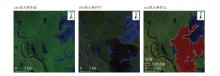
图1
使用Labelme结合3个时相野火发生影像进行标注 注:该图为同一地区下不同时间的Sentinel-2影像,其中(b)的影像序列号为:20190108T022059_20190108T022054_T52TFN。"
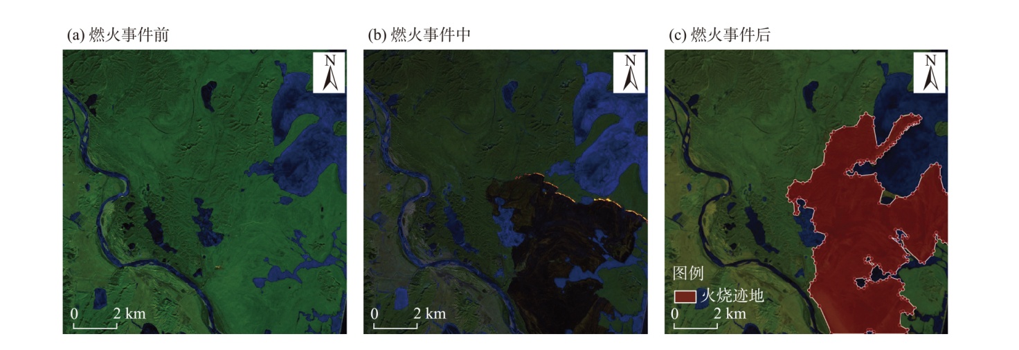
表3
光谱指数特征选取及简称"
| 简称 | 光谱指数 |
|---|---|
| EVI | 增强型植被指数 |
| NDVI | 归一化植被指数 |
| IBI | 生物完整性指数 |
| BSI | 裸土指数 |
| SSI | 土壤表面指数 |
| RVI | 比率植被指数 |
| DVI | 差异植被指数 |
| GCVI | 绿色叶绿素植被指数 |
| NBR | 归一化燃烧指数 |
| NBR2 | 改进的归一化燃烧指数 |
| BAI | 燃烧区域指数 |
| MIRBI | 中红外燃烧指数 |
| NBR_PLUS | 增强型归一化燃烧指数 |
| BAIS2 | 燃烧区域指数 |
| REP | 红边位置指数 |
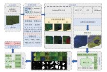
图2
技术路线 注:NDVI为归一化植被指数;NBR为归一化燃烧指数;NBR2为改进的归一化燃烧指数;NBR_PLUS为增强型归一化燃烧指数;MIRBI为中红外燃烧指数;GEE_RF为使用谷歌地球云计算平台内置的随机森林模型;RF为随机森林;XGBoost为一种高效、强大的梯度提升决策树算法;VV为垂直发射-垂直接收;VH为垂直发射-水平接收;RE1、RE4为红边波段1和红边波段4;S1、S2为哨兵2号的短波红外1波段和短波红外2波段;F1分数为精确率和召回率的调和平均数,是综合评价模型性能的指标。下同。"

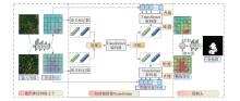
图3
BIT_CD模型的网络结构"
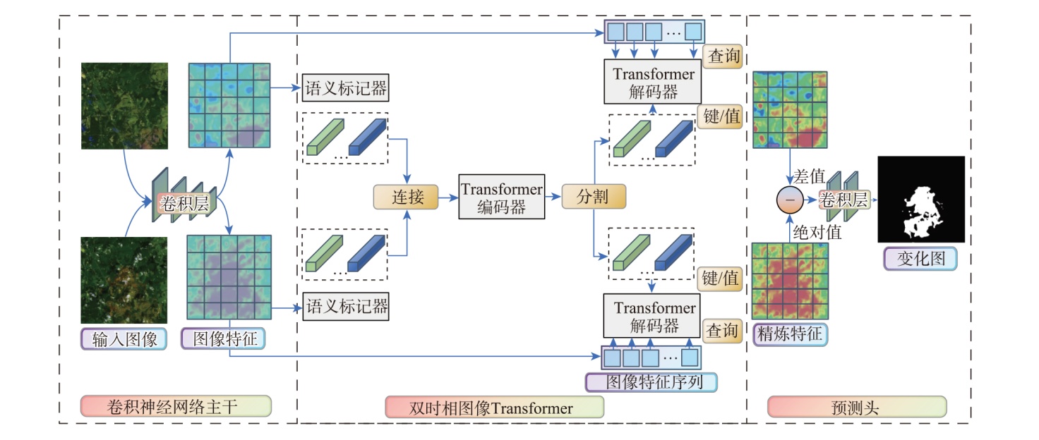
图4
3种机器学习模型的SHAP特征重要性综合排序 注:图中总体重要性含义见表1~3。"

表4
特征组合详情"
| 编号 | 植被指数 | Sentinel-1 | 原始波段 | 组合方式 |
|---|---|---|---|---|
| 1 | - | - | RE4、S2、RE2、S1、RE1、RE3 | GEE_RF |
| 2 | - | - | RE4、RE1、S1、RE3、NIR、S2 | RF |
| 3 | - | - | RE4、S2、S1、RE1、G、R | XGBoost |
| 4 | - | VV、VH | RE4、S2、S1、RE1 | 无光谱指数 |
| 5 | MIRBI、NBR_PLUS | - | RE4、S2、S1、RE1 | 无Sentinel-1 |
| 6 | MIRBI、NBR2 | - | RE4、S2、S1、RE1 | 无Sentinel-1 |
| 7 | NBR2、NBR_PLUS | - | RE4、S2、S1、RE1 | 无Sentinel-1 |
| 8 | MIRBI | VV、VH | RE4、S1、RE1 | 一种光谱指数 |
| 9 | MIRBI | VV、VH | RE4、S2、RE1 | 一种光谱指数 |
| 10 | MIRBI | VV、VH | RE4、S2、S1 | 一种光谱指数 |
| 11 | MIRBI | VV、VH | S2、S1、RE1 | 一种光谱指数 |
| 12 | NBR_PLUS | VV、VH | RE4、S1、RE1 | 一种光谱指数 |
| 13 | NBR_PLUS | VV、VH | RE4、S2、RE1 | 一种光谱指数 |
| 14 | NBR_PLUS | VV、VH | RE4、S2、S1 | 一种光谱指数 |
| 15 | NBR_PLUS | VV、VH | S2、S1、RE1 | 一种光谱指数 |
| 16 | NBR2 | VV、VH | RE4、S1、RE1 | 一种光谱指数 |
| 17 | NBR2 | VV、VH | RE4、S2、RE1 | 一种光谱指数 |
| 18 | NBR2 | VV、VH | RE4、S2、S1 | 一种光谱指数 |
| 19 | NBR2 | VV、VH | S2、S1、RE1 | 一种光谱指数 |
| 20 | - | - | R、G、B | RGB |
表5
20种特征组合在测试集的性能表现"
| 特征组合方式 | OA | IoU | F1 | Precision | Recall |
|---|---|---|---|---|---|
| GEE_RF | 92.09 | 53.82 | 69.98 | 73.57 | 66.72 |
| RF | 92.37 | 56.29 | 72.04 | 73.00 | 71.10 |
| XGBoost | 92.71 | 56.52 | 72.22 | 76.24 | 68.61 |
| VV_VH_RE4_S2_S1_RE1 | 91.67 | 49.62 | 66.33 | 75.14 | 59.37 |
| MIRBI_NBR_PLUS_RE4_S2_S1_RE1 | 92.67 | 56.09 | 71.87 | 76.56 | 67.72 |
| MIRBI_NBR2_RE4_S2_S1_RE1 | 92.13 | 51.67 | 68.13 | 77.31 | 60.90 |
| NBR2_NBR_PLUS_RE4_S2_S1_RE1 | 92.31 | 52.85 | 69.15 | 77.60 | 62.36 |
| MIRBI_VV_VH_RE4_S1_RE1 | 92.12 | 56.03 | 71.82 | 71.03 | 72.63 |
| MIRBI_VV_VH_RE4_S2_RE1 | 91.86 | 52.86 | 69.16 | 72.58 | 66.05 |
| MIRBI_VV_VH_RE4_S2_S1 | 92.76 | 58.00 | 73.42 | 74.53 | 72.34 |
| MIRBI_VV_VH_S2_S1_RE1 | 92.07 | 53.03 | 69.31 | 74.53 | 64.77 |
| NBR_PLUS_VV_VH_RE4_S1_RE1 | 92.29 | 53.64 | 69.83 | 76.07 | 64.53 |
| NBR_PLUS_VV_VH_RE4_S2_RE1 | 92.09 | 55.29 | 71.21 | 71.66 | 70.75 |
| NBR_PLUS_VV_VH_RE4_S2_S1 | 92.92 | 57.62 | 73.11 | 76.95 | 69.64 |
| NBR_PLUS_VV_VH_S2_S1_RE1 | 92.50 | 56.10 | 71.87 | 74.64 | 69.31 |
| NBR2_VV_VH_RE4_S1_RE1 | 91.35 | 50.24 | 66.88 | 71.03 | 63.18 |
| NBR2_VV_VH_RE4_S2_RE1 | 91.49 | 49.46 | 66.18 | 73.43 | 60.24 |
| NBR2_VV_VH_RE4_S2_S1 | 91.96 | 51.52 | 68.00 | 75.51 | 61.86 |
| NBR2_VV_VH_S2_S1_RE1 | 92.17 | 50.15 | 66.80 | 80.64 | 57.02 |
| RGB | 90.56 | 44.24 | 61.34 | 68.30 | 55.68 |
图5
模型在最优以及最差数据集上的训练F1得分"
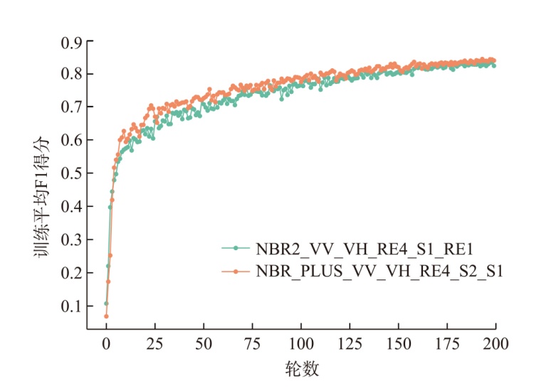
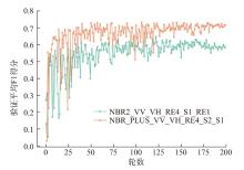
图6
模型在最优以及最差数据集上的验证F1得分"
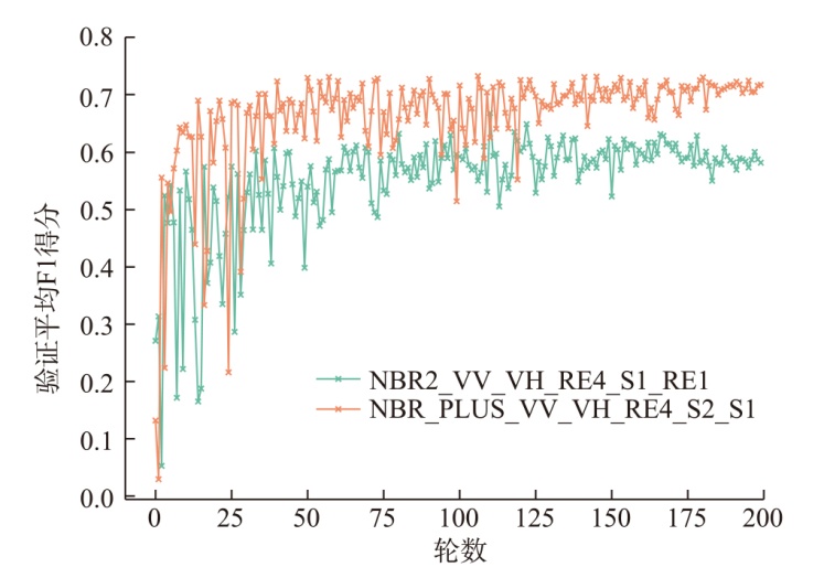
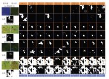
图7
BIT_CD模型20种特征组合下的训练预测结果"
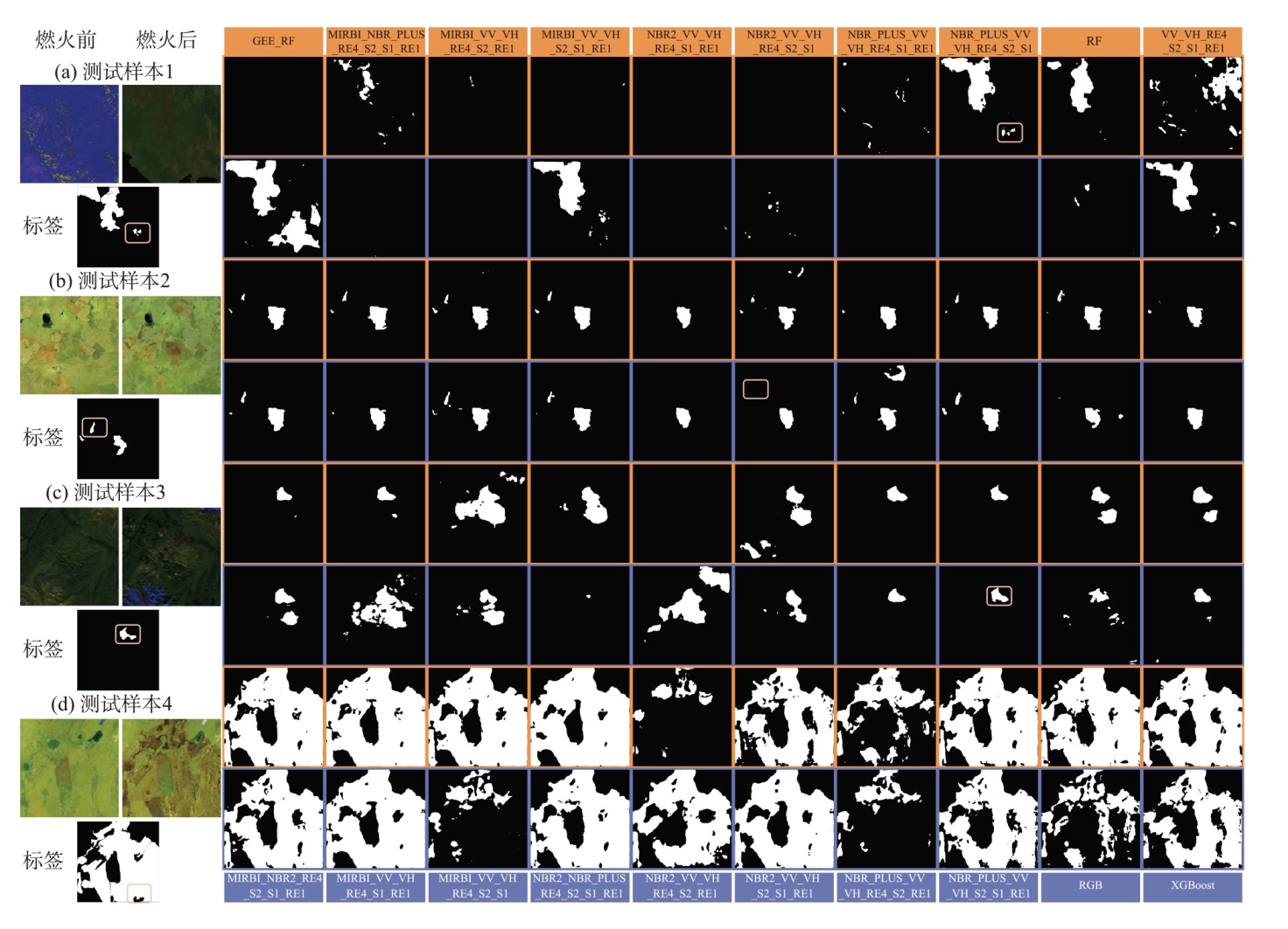
表6
20种特征组合在4个测试样本的平均表现"
| 特征组合方式 | OA | IoU | F1 | Precision | Recall |
|---|---|---|---|---|---|
| GEE_RF | 93.79 | 52.24 | 58.54 | 64.16 | 61.20 |
| RF | 94.71 | 57.94 | 69.35 | 83.04 | 71.29 |
| XGBoost | 94.39 | 63.58 | 79.44 | 77.22 | 77.41 |
| VV_VH_RE4_S2_S1_RE1 | 90.28 | 43.74 | 50.07 | 64.25 | 53.67 |
| MIRBI_NBR_PLUS_RE4_S2_S1_RE1 | 93.88 | 57.51 | 76.65 | 75.57 | 70.37 |
| MIRBI_NBR2_RE4_S2_S1_RE1 | 92.70 | 56.95 | 61.32 | 90.77 | 70.64 |
| NBR2_NBR_PLUS_RE4_S2_S1_RE1 | 95.53 | 55.50 | 84.15 | 67.69 | 65.93 |
| MIRBI_VV_VH_RE4_S1_RE1 | 90.77 | 38.37 | 43.52 | 66.92 | 46.12 |
| MIRBI_VV_VH_RE4_S2_RE1 | 91.28 | 41.13 | 68.87 | 70.21 | 48.47 |
| MIRBI_VV_VH_RE4_S2_S1 | 82.41 | 26.89 | 46.84 | 48.40 | 36.67 |
| MIRBI_VV_VH_S2_S1_RE1 | 92.16 | 41.92 | 44.06 | 68.93 | 50.43 |
| NBR_PLUS_VV_VH_RE4_S1_RE1 | 86.13 | 40.12 | 59.91 | 53.37 | 51.95 |
| NBR_PLUS_VV_VH_RE4_S2_RE1 | 82.81 | 31.45 | 53.05 | 45.32 | 42.30 |
| NBR_PLUS_VV_VH_RE4_S2_S1 | 95.92 | 71.87 | 81.60 | 85.55 | 83.39 |
| NBR_PLUS_VV_VH_S2_S1_RE1 | 92.90 | 54.07 | 60.59 | 65.87 | 62.76 |
| NBR2_VV_VH_RE4_S1_RE1 | 82.12 | 16.85 | 42.88 | 19.18 | 23.02 |
| NBR2_VV_VH_RE4_S2_RE1 | 88.25 | 33.10 | 44.24 | 58.26 | 41.98 |
| NBR2_VV_VH_RE4_S2_S1 | 91.38 | 38.91 | 44.82 | 64.28 | 48.00 |
| NBR2_VV_VH_S2_S1_RE1 | 93.00 | 42.64 | 65.87 | 59.63 | 52.74 |
| RGB | 86.63 | 33.23 | 77.59 | 46.32 | 46.59 |
| [1] | Hamilton D, Brothers K, McCall C, et al. Mapping forest burn extent from hyperspatial imagery using machine learning[J]. Remote Sensing, 2021, 13(19): 3843, doi: 10.3390/rs13193843. |
| [2] | Cunningham C X, Williamson G J, Bowman D M J S. Increasing frequency and intensity of the most extreme wildfires on earth[J]. Nature Ecology & Evolution, 2024, 8: 1420-1425. |
| [3] | Rahman R A, White B, Ma C B. The effect of growth, deforestation, forest fires, and volcanoes on Indonesian regional air quality[J]. Journal of Cleaner Production, 2024, 457: 142311, doi: 10.1016/j.jclepro.2024.142311. |
| [4] | Yang W L, Wu M S, Kong L, et al. A spatial weight sampling method integrating the spatiotemporal pattern enhances the understanding of the occurrence mechanism of wildfires in the southwestern mountains of China[J]. Forest Ecology and Management, 2025, 585: 122619, doi: 10.1016/j.foreco.2025.122619. |
| [5] |
Qin Y J, Wang H C, Wang Y M, et al. Wildfires in southeast Asia pollute the atmosphere in the northern south China sea[J]. Science Bulletin, 2024, 69(8): 1011-1015.
doi: 10.1016/j.scib.2024.02.026 pmid: 38431468 |
| [6] |
夏文浩, 霍瑜, 逯渊, 等. 新疆农业碳排放的时空差异与空间溢出效应分析[J]. 干旱区地理, 2024, 47(6): 1084-1096.
doi: 10.12118/j.issn.1000-6060.2023.344 |
|
[Xia Wenhao, Huo Yu, Lu Yuan, et al. Spatialtemporal differences and spatial spillover effects of agricultural carbon emissions in Xinjiang[J]. Arid Land Geography, 2024, 47(6): 1084-1096.]
doi: 10.12118/j.issn.1000-6060.2023.344 |
|
| [7] | Hethcoat M G, Carreiras J M B, Edwards D P, et al. Detecting tropical selective logging with C-band SAR data may require a time series approach[J]. Remote Sensing of Environment, 2021, 259: 112411, doi: 10.1016/j.rse.2021.112411. |
| [8] |
Hethcoat M G, Edwards D P, Carreiras J M B, et al. A machine learning approach to map tropical selective logging[J]. Remote Sensing of Environment, 2019, 221: 569-582.
doi: 10.1016/j.rse.2018.11.044 |
| [9] | Chen W T, Li X J, He H X, et al. A review of fine-scale land use and land cover classification in open-pit mining areas by remote sensing techniques[J]. Remote Sensing, 2018, 10(1): 15, doi: 10.3390/rs10010015. |
| [10] |
Chen Y, Morton D C, Randerson J T. Remote sensing for wildfire monitoring: Insights into burned area, emissions, and fire dynamics[J]. One Earth, 2024, 7(6): 1022-1028.
doi: 10.1016/j.oneear.2024.05.014 |
| [11] |
Schroeder W, Oliva P, Giglio L, et al. Active fire detection using Landsat-8/OLI data[J]. Remote Sensing of Environment, 2016, 185: 210-220.
doi: 10.1016/j.rse.2015.08.032 |
| [12] | Radeloff V C, Roy D P, Wulder M A, et al. Need and vision for global medium-resolution Landsat and Sentinel-2 data products[J]. Remote Sensing of Environment, 2024, 300: 113918, doi: 10.1016/j.rse.2023.113918. |
| [13] |
Bastarrika A, Rodriguez-Montellano A, Roteta E, et al. An automatic procedure for mapping burned areas globally using Sentinel-2 and VIIRS/MODIS active fires in Google Earth Engine[J]. ISPRS Journal of Photogrammetry and Remote Sensing, 2024, 218: 232-245.
doi: 10.1016/j.isprsjprs.2024.08.019 |
| [14] |
Lin Z Y, Chen F, Niu Z, et al. An active fire detection algorithm based on multi-temporal FengYun-3C VIRR data[J]. Remote Sensing of Environment, 2018, 211: 376-387.
doi: 10.1016/j.rse.2018.04.027 |
| [15] | Kang Y, Sung T, Im J. Toward an adaptable deep-learning model for satellite-based wildfire monitoring with consideration of environmental conditions[J]. Remote Sensing of Environment, 2023, 298: 113814, doi: 10.1016/j.rse.2023.113814. |
| [16] | 曾洪涛. 基于 GK2A 卫星数据的野火实时监测方法[D]. 成都: 电子科技大学, 2024. |
| [Zeng Hongtao. Near real-time wildfire monitoring methods based on GK2A data[D]. Chengdu: University of Electronic Science and Technology of China, 2024.] | |
| [17] | 饶月明, 王川, 黄华国. 联合多源遥感数据监测四川木里县森林火灾[J]. 遥感学报, 2020, 24(5): 559-570. |
| [Rao Yueming, Wang Chuan, Huang Huaguo. Forest fire monitoring based on multisensor remote sensing techniques in Muli County, Sichuan Province[J]. Journal of Remote Sensing, 2020, 24(5): 559-570.] | |
| [18] | Meneses B M. Vegetation recovery patterns in burned areas assessed with Landsat 8 OLI imagery and environmental biophysical data[J]. Fire, 2021, 4(4): 76, doi: 10.3390/fire4040076. |
| [19] | López G M J, Caselles V. Mapping burns and natural reforestation using thematic mapper data[J]. Geocarto International, 1991, 6(1): 31-37. |
| [20] | Rouse J W, Haas R H, Schell J A, et al. Monitoring the vernal advancement and retrogradation (green wave effect) of natural vegetation[R]. Greenbelt: NASA/GSFC, 1974. |
| [21] |
Pettorelli N, Vik J O, Mysterud A, et al. Using the satellite-derived NDVI to assess ecological responses to environmental change[J]. Trends in Ecology & Evolution, 2005, 20(9): 503-510.
doi: 10.1016/j.tree.2005.05.011 |
| [22] | Xu H Q, Chen J H, He G J, et al. Immediate assessment of forest fire using a novel vegetation index and machine learning based on multi-platform, high temporal resolution remote sensing images[J]. International Journal of Applied Earth Observation and Geoinformation, 2024, 134: 104210, doi: 10.1016/j.jag.2024.104210. |
| [23] | 卢涛, 张军, 胡文英. 基于Sentinel-2A/B数据的火烧迹地提取方法研究[J]. 三峡生态环境监测, 2021, 6(2): 52-60. |
| [Lu Tao, Zhang Jun, Hu Wenying. Extraction method of burned area based on Sentinel-2A/B data[J]. Ecology and Environmental Monitoring of Three Gorges, 2021, 6(2): 52-60.] | |
| [24] |
Zhang P Z, Ban Y F, Nascetti A. Total-variation regularized U-Net for wildfire burned area mapping based on Sentinel-1 C-band SAR backscattering data[J]. ISPRS Journal of Photogrammetry and Remote Sensing, 2023, 203: 301-313.
doi: 10.1016/j.isprsjprs.2023.07.024 |
| [25] |
Ban Y F, Zhang P Z, Nascetti A, et al. Near real-time wildfire progression monitoring with Sentinel-1 SAR time series and deep learning[J]. Scientific Reports, 2020, 10(1): 1322, doi: 10.1038/s41598-019-56967-x.
pmid: 31992723 |
| [26] |
Stavrakoudis D, Katagis T, Minakou C, et al. Automated burned scar mapping using sentinel-2 imagery[J]. Journal of Geographic Information System, 2020, 12(3): 221-240.
doi: 10.4236/jgis.2020.123014 |
| [27] | Tariq A, Jiango Y, Lu L L, et al. Integrated use of sentinel-1 and sentinel-2 data and open-source machine learning algorithms for burnt and unburnt scars[J]. Geomatics, Natural Hazards and Risk, 2023, 14(1): 2190856, doi: 10.1080/19475705.2023.2190856. |
| [28] |
Gorelick N, Hancher M, Dixon M, et al. Google earth engine: Planetary-scale geospatial analysis for everyone[J]. Remote Sensing of Environment, 2017, 202: 18-27.
doi: 10.1016/j.rse.2017.06.031 |
| [29] |
LeCun Y, Bengio Y, Hinton G. Deep learning[J]. Nature, 2015, 521(7553): 436-444.
doi: 10.1038/nature14539 |
| [30] | Liu P, Liu Y X, Guo X X, et al. Burned area detection and mapping using time series Sentinel-2 multispectral images[J]. Remote Sensing of Environment, 2023, 296: 113753, doi: 10.1016/j.rse.2023.113753. |
| [31] | Sui T, Huang Q Y, Wu M D, et al. BiAU-Net: Wildfire burnt area mapping using bi-temporal Sentinel-2 imagery and U-Net with attention mechanism[J]. International Journal of Applied Earth Observation and Geoinformation, 2024, 132: 104034, doi: 10.1016/j.jag.2024.104034. |
| [32] | Zhao F, Sun R, Zhong L H, et al. Monthly mapping of forest harvesting using dense time series Sentinel-1 SAR imagery and deep learning[J]. Remote Sensing of Environment, 2022, 269: 112822, doi: 10.1016/j.rse.2021.112822. |
| [33] | Chen H, Qi Z, Shi Z. Remote sensing image change detection with Transformers[J]. IEEE Transactions on Geoscience and Remote Sensing, 2022, 60: 1-14. |
| [34] | Vaswani A, Shazeer N, Parmar N, et al. Attention is all you need[C]// Neural Information Processing Systems. Proceedings of the 31st International Conference on Neural Information Processing Systems. New York: Curran Associates Inc., 2017: 6000-6010. |
| [35] | Ronneberger O, Fischer P, Brox T. U-Net: Convolutional networks for biomedical image segmentation[J]. arXiv, 2015, doi: 10.48550/arXiv.1505.04597. |
| [36] |
Collins L, Griffioen P, Newell G, et al. The utility of random forests for wildfire severity mapping[J]. Remote Sensing of Environment, 2018, 216: 374-384.
doi: 10.1016/j.rse.2018.07.005 |
| [37] |
方创琳, 刘海猛, 罗奎, 等. 中国人文地理综合区划[J]. 地理学报, 2017, 72(2): 179-196.
doi: 10.11821/dlxb201702001 |
|
[Fang Chuanglin, Liu Haimeng, Luo Kui, et al. Comprehensive regionalization of human geography in China[J]. Acta Geographica Sinica, 2017, 72(2): 179-196.]
doi: 10.11821/dlxb201702001 |
|
| [38] | Feurdean A, Florescu G, Tanţău I, et al. Recent fire regime in the southern boreal forests of western siberia is unprecedented in the last five millennia[J]. Quaternary Science Reviews, 2020, 244: 106495, doi: 10.1016/j.quascirev.2020.106495. |
| [39] |
金相皓, 李鹏, 李霞, 等. 基于CHELSA的1980—2018年南亚——东南亚气候变化特征与趋势分析[J]. 地理科学进展, 2023, 42(7): 1365-1379.
doi: 10.18306/dlkxjz.2023.07.011 |
|
[Jin Xianghao, Li Peng, Li Xia, et al. A CHELSA-based analysis of climate change characteristics and trends in south and southeast Asia (SSEA) during 1980—2018[J]. Progress in Geography, 2023, 42(7): 1365-1379.]
doi: 10.18306/dlkxjz.2023.07.011 |
|
| [40] |
杨晓颖, 玉山, 都瓦拉, 等. 蒙古高原草原火灾风险评价研究[J]. 干旱区地理, 2021, 44(4): 1032-1044.
doi: 10.12118/j.issn.1000–6060.2021.04.16 |
|
[Yang Xiaoying, Yu Shan, Duwala, et al. Risk assessment of grassland fire on the Mongolian Plateau[J]. Arid Land Geography, 2021, 44(4): 1032-1044.]
doi: 10.12118/j.issn.1000–6060.2021.04.16 |
|
| [41] |
Zheng B, Ciais P, Chevallier F, et al. Record-high CO2 emissions from boreal fires in 2021[J]. Science, 2023, 379(6635): 912-917.
doi: 10.1126/science.ade0805 pmid: 36862792 |
| [42] | 何阳, 杨进, 马勇, 等. 基于Landsat-8陆地卫星数据的火点检测方法[J]. 红外与毫米波学报, 2016, 35(5): 600-609. |
| [He Yang, Yang Jin, Ma Yong, et al. A method for fire detection using Landsat 8 data[J]. Journal of Infrared and Millimeter Waves, 2016, 35(5): 600-609.] | |
| [43] | Roy D P, Huang H Y, Boschetti L, et al. Landsat-8 and Sentinel-2 burned area mapping-A combined sensor multi-temporal change detection approach[J]. Remote Sensing of Environment, 2019, 231: 111254, doi: 10.1016/j.rse.2019.111254. |
| [44] |
De Almeida Pereira G H, Fusioka A M, Nassu B T, et al. Active fire detection in Landsat-8 imagery: A large-scale dataset and a deep-learning study[J]. ISPRS Journal of Photogrammetry and Remote Sensing, 2021, 178: 171-186.
doi: 10.1016/j.isprsjprs.2021.06.002 |
| [45] | Pulvirenti L, Squicciarino G, Fiori E, et al. Near real-time generation of a country-level burned area database for Italy from Sentinel-2 data and active fire detections[J]. Remote Sensing Applications: Society and Environment, 2023, 29: 100925, doi: 10.1016/j.rsase.2023.100925. |
| [46] | 周乐民. 基于多源遥感影像的森林火场信息提取与应用——以“4.20冕宁县森林火灾”为例[D]. 成都: 西南交通大学, 2022. |
| [Zhou Lemin. Extraction and application of forest fire information based on multi source remote sensing imagery: A case study of “4.20 mianning county forest fire”[D]. Chengdu: Southwest Jiaotong University, 2022.] | |
| [47] | Pasquarella V J, Brown C F, Czerwinski W, et al. Comprehensive quality assessment of optical satellite imagery using weakly supervised video learning[C]// IEEE/CVF. Conference on Computer Vision and Pattern Recognition Workshops (CVPRW). New York: IEEE. 2023: 2125-2135. |
| [48] |
Russell B C, Torralba A, Murphy K P, et al. LabelMe: A database and web-based tool for image annotation[J]. International Journal of Computer Vision, 2008, 77(1): 157-173.
doi: 10.1007/s11263-007-0090-8 |
| [49] |
Breiman L. Random forests[J]. Machine Learning, 2001, 45(1): 5-32.
doi: 10.1023/A:1010933404324 |
| [50] | Chen T Q, Guestrin C. XGBoost: A scalable tree boosting system[C]// Proceedings of the 22nd ACM Sigkdd International Conference on Knowledge Discovery and Data Mining. New York: Association for Computing Machinery, 2016: 785-794. |
| [51] |
赵国兵, 郑江华, 王蕾, 等. 基于RF分类调优和SNIC聚类的新疆红枣种植区遥感提取[J]. 干旱区地理, 2024, 47(6): 1004-1014.
doi: 10.12118/j.issn.1000-6060.2023.382 |
|
[Zhao Guobing, Zheng Jianghua, Wang Lei, et al. Remote sensing extraction of jujube planting area in Xinjiang based on RF classification optimization and SNIC clustering[J]. Arid Land Geography, 2024, 47(6): 1004-1014.]
doi: 10.12118/j.issn.1000-6060.2023.382 |
|
| [52] |
Genuer R, Poggi J M, Tuleau-Malot C. Variable selection using random forests[J]. Pattern Recognition Letters, 2010, 31(14): 2225-2236.
doi: 10.1016/j.patrec.2010.03.014 |
| [53] |
Verrelst J, Muñoz J, Alonso L, et al. Machine learning regression algorithms for biophysical parameter retrieval: Opportunities for sentinel-2 and -3[J]. Remote Sensing of Environment, 2012, 118: 127-139.
doi: 10.1016/j.rse.2011.11.002 |
| [54] |
Friedman J H. Greedy function approximation: A gradient boosting machine[J]. Annals of Statistics, 2001, 29(5): 1189-1232.
doi: 10.1214/aos/1013203450 |
| [55] | Bergstra J, Bardenet R, Bengio Y, et al. Algorithms for hyper-parameter optimization[C]// Neural Information Processing Systems. Proceedings of the 25th International Conference on Neural Information Processing Systems. New York: Curran Associates Inc., 2011: 2546-2554. |
| [1] | 周灵敏, 伊木然·库鲁万, 玉素甫江·如素力, 吴海智, 娜扎开提·尼加提. 中国西北干旱区大型湖泊湖冰物候时空差异及影响因素[J]. 干旱区地理, 2026, 49(3): 484-495. |
| [2] | 王圣节, 张庆红, 桑铭键. 基于改进深度学习模型的干旱区城市PM2.5浓度预测与应用研究[J]. 干旱区地理, 2026, 49(2): 343-355. |
| [3] | 郭佳丽, 马勇刚, 潘恒, 李娜, 孙长宁, 孙倩, 周文昶, 党瑀璇. 艾比湖春夏季土壤盐渍化卫星监测对比分析[J]. 干旱区地理, 2025, 48(12): 2143-2157. |
| [4] | 袁盼丽,汪传建,赵庆展,王学文,任媛媛,杨启原. 基于深度学习的寒旱区多时序影像土地利用及变化监测——以新疆莫索湾垦区为例[J]. 干旱区地理, 2021, 44(6): 1717-1728. |
| [5] | 卢文路, 刘志锋, 何春阳, 夏沛. 基于Sentinel-1A合成孔径雷达数据和全卷积网络的城市建设用地监测方法研究 [J]. 干旱区地理, 2020, 43(3): 750-760. |
|
||