| [1] |
Culling W. Multicyclic streams and the equilibrium theory of grade[J]. Journal of Geology, 1957, 65(3): 259-274.
doi: 10.1086/626430
|
| [2] |
Howard D A. Geomorphological systems; equilibrium and dynamics[J]. American Journal of Science, 1965, 263(4): 302-312.
doi: 10.2475/ajs.263.4.302
|
| [3] |
Strahler A N. Dynamic basis of geomorphology[J]. Geological Society of America Bulletin, 1952, 63(9): 923-938.
doi: 10.1130/0016-7606(1952)63[923:DBOG]2.0.CO;2
|
| [4] |
Phillips J D. Deterministic chaos and historical geomorphology: A review and look forward[J]. Geomorphology, 2005, 76(1): 109-121.
doi: 10.1016/j.geomorph.2005.10.004
|
| [5] |
Phillips J D. Emergent and pseudo-equilibrium in geomorphology[J]. Geomorphology, 2011, 132(3): 319-326.
doi: 10.1016/j.geomorph.2011.05.017
|
| [6] |
Ellen W. Time and the rivers flowing: Fluvial geomorphology since 1960[J]. Geomorphology, 2014, 216: 263-282.
doi: 10.1016/j.geomorph.2014.04.012
|
| [7] |
励强, 陆中臣, 袁宝印. 地貌发育阶段的定量研究[J]. 地理学报, 1990, 45(1): 110-120.
doi: 10.11821/xb199001011
|
|
[Li Qiang, Lu Zhongchen, Yuan Baoyin. Quantitative study of the stage of geomorphological evolution[J]. Acta Geographica Sinica, 1990, 45(1): 110-120.]
doi: 10.11821/xb199001011
|
| [8] |
马新中, 陆中臣, 金德生. 流域地貌系统的侵蚀演化与耗散结构[J]. 地理学报, 1993, 48(4): 367-376.
doi: 10.11821/xb199304008
|
|
[Ma Xinzhong, Lu Zhongchen, Jin Desheng. Evolution and pissipative structure in the drainage-geomorphic system[J]. Acta Geographica Sinic, 1993, 48(4): 367-376.]
doi: 10.11821/xb199304008
|
| [9] |
Leopold L B, Langbein W B. The concept of entropy in landscape evolution[J]. USGS Professional Paper, 1962, 500: 1-20.
|
| [10] |
Zhao W D, Tang G A, Ma L, et al. Digital elevation model-based watershed geomorphic entropy for the study of landscape evolution of a watershed geomorphic system in the loess landforms of China[J]. Progress in Physical Geography, 2017, 41(2): 139-153.
|
| [11] |
Shannon C E. A mathematical theory of communication[J]. Bell Systems Technical Journal, 1948, 27(4): 623-656.
doi: 10.1002/j.1538-7305.1948.tb00917.x
|
| [12] |
Neumann J. The topological information content of a map: An attempt at a rehabilitation of information theory in cartography[J]. Cartographica: The International Journal for Geographic Information and Geovisualization, 1994, 31(1): 26-34.
doi: 10.3138/U626-551H-64K4-9687
|
| [13] |
Higashi M, Klir G J. Measures of uncertainty and information based on possibility distributions[J]. Readings in Fuzzy Sets for Intelligent Systems, 1993, 9(1): 217-232.
|
| [14] |
艾南山. 侵蚀流域系统的信息熵[J]. 水土保持学报, 1987, 1(2): 1-8.
|
|
[Ai Nanshan. Comentropy in erosional drainage-system[J]. Journal of Soil and Water Conservation, 1987, 1(2): 1-8.]
|
| [15] |
岳天祥, 艾南山, 张英保. 论流域系统稳定性的判别指标——超熵[J]. 水土保持学报, 1989, 3(2): 20-28.
|
|
[Yue Tianxiang, Ai Nanshan, Zhang Yingbao. Superentropy: A criterion for determining stability of drainage system[J]. Journal of Soil and Water Conservation, 1989, 3(2): 20-28.]
|
| [16] |
张宝军, 熊东红, 董一帆, 等. 地貌信息熵理论在冲沟沟头活跃度评价中的应用初探[J]. 中国水土保持, 2015(1): 3-7, 69.
|
|
[Zhang Baojun, Xiong Donghong, Dong Yifan, et al. Application of geomorphologic information entropy theory to evaluation of gulley head activity[J]. Soil and Water Conservation in China, 2015(1): 3-7, 69.]
|
| [17] |
谢涛, 尹前锋, 高贺, 等. 基于地貌信息熵的天山公路冰川泥石流危险性评价[J]. 冰川冻土, 2019, 41(2): 400-406.
|
|
[Xie Tao, Yin Qianfeng, Gao He, et al. Risk assessment of glacial debris flow along the Tianshan Highway based on geomorphic information entropy[J]. Journal of Glaciology and Geocryology, 2019, 41(2): 400-406.]
|
| [18] |
陈楠, 林宗坚, 李成名, 等. 基于信息论的不同比例尺DEM地形信息比较分析[J]. 遥感信息, 2004(3): 5-9.
|
|
[Chen Nan, Lin Zongjian, Li Chengming, et al. A comparison of topographic information from different scales DEMs based on information theory[J]. Remote Sensing Information, 2004(3): 5-9.]
|
| [19] |
陈楠, 汤国安, 刘咏梅, 等. 基于不同比例尺的DEM地形信息比较[J]. 西北大学学报(自然科学版), 2003, 33(2): 237-240.
|
|
[Chen Nan, Tang Guo’an, Liu Yongmei, et al. Comparison of topographic of DEM with different scales[J]. Journal of Northwest University (Natural Science Edition), 2003, 33(2): 237-240.]
|
| [20] |
李发源, 汤国安, 贾旖旎, 等. 坡谱信息熵尺度效应及空间分异[J]. 地球信息科学, 2007, 9(4): 13-18.
|
|
[Li Fayuan, Tang Guo’an, Jia Yini, et al. Scale effect and spatial distribution of slope spectrum’s information entropy[J]. Journal of Geo-information Science, 2007, 9(4): 13-18.]
|
| [21] |
张广, 刘彦花, 李彪. 基于信息熵和DEM地形信息量的景观预测[J]. 北京测绘, 2019, 33(8): 867-871.
|
|
[Zhang Guang, Liu Yanhua, Li Biao. Prediction of landscape based on information entropy and DEM terrain information capacity[J]. Beijing Surveying and Mapping, 2019, 33(8): 867-871.]
|
| [22] |
姜琼. 基于DEM的流域地貌系统势能信息熵及其地貌演化意义研究[D]. 合肥: 合肥工业大学, 2019.
|
|
[Jiang Qiong. DEM-based study on potential energy information entropy of watershed geomorphic system and its landform evolution significance[D]. Hefei: Hefei University of Technology, 2019.]
|
| [23] |
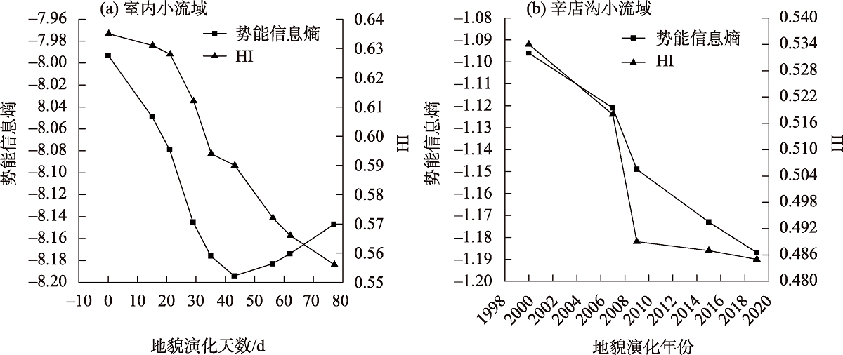
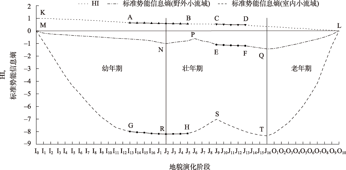
赵卫东, 周文怡, 马雷, 等. 基于势能信息熵的黄土小流域沟谷网络演化特征研究[J]. 地理与地理信息科学, 2021, 37(6): 1-6.
|
|
[Zhao Weidong, Zhou Wenyi, Ma Lei, et al. Study on evolution characteristics of valley network in small loess watershed based on potential energy information entropy[J]. Geography and Geo-information Science, 2021, 37(6): 1-6.]
|
| [24] |
马煜栋, 杨帅, 韩静, 等. 陕西榆林地区无定河流域淤地坝遥感解译[J]. 干旱区地理, 2022, 45(3): 786-791.
|
|
[Ma Yudong, Yang Shuai, Han Jing, et al. Remote sensing interpretation of check dams in Wuding River Basin in Yulin Area of Shaanxi[J]. Arid Land Geography, 2022, 45(3): 786-791.]
|
| [25] |
安彬, 肖薇薇, 张淑兰, 等. 1960—2017年黄土高原地表温度时空变化特征[J]. 干旱区地理, 2021, 44(3): 778-785.
|
|
[An Bin, Xiao Weiwei, Zhang Shulan, et al. Spatial and temporal characteristics of surface temperature in the Loess Plateau during 1961—2017[J]. Arid Land Geography, 2021, 44(3): 778-785.]
|
| [26] |
党维勤, 崔乐乐, 郝鲁东, 等. 黄土高原辛店沟水保示范园探索[J]. 中国水利, 2021(16): 40-42, 47.
|
|
[Dang Weiqin, Cui Lele, Hao Ludong, et al. Exploration of Xindiangou soil and water conservation demonstration park on the Loess Plateau[J]. China Water Resources, 2021(16): 40-42, 47.]
|
| [27] |
Prunkl C. On the equivalence of von Neumann and thermodynamic entropy[J]. Philosophy of Science, 2020, 87(2): 262-280.
doi: 10.1086/707565
|
| [28] |
田剑, 汤国安, 周毅, 等. 黄土高原沟谷密度空间分异特征研究[J]. 地理科学, 2013, 33(5): 622-628.
doi: 10.13249/j.cnki.sgs.2013.05.622
|
|
[Tian Jian, Tang Guo’an, Zhou Yi, et al. Spatial variation of gully density in the Loess Plateau[J]. Scientia Geographica Sinica, 2013, 33(5): 622-628.]
doi: 10.13249/j.cnki.sgs.2013.05.622
|
| [29] |
南学良, 马文明, 王水献. 基于DEM的新疆开都河流域河网提取研究[J]. 甘肃科学学报, 2014, 26(1): 37-41.
|
|
[Nan Xueliang, Ma Wenming, Wang Shuixian. DEM-based extraction of river network of the Kaidu River Basin in Xinjiang[J]. Journal of Gansu Sciences, 2014, 26(1): 37-41.]
|
| [30] |
Pike R J, Wilson S E. Elevation-relief ratio, hypsometric integral, and geomorphic area-altitude analysis[J]. Geological Society of America Bulletin, 1971, 82(4): 1079-1084.
doi: 10.1130/0016-7606(1971)82[1079:ERHIAG]2.0.CO;2
|
| [31] |
常直杨, 王建, 白世彪, 等. 面积高程积分值计算方法的比较[J]. 干旱区资源与环境, 2015, 29(3): 171-175.
|
|
[Chang Zhiyang, Wang Jian, Bai Shibiao, et al. Comparison of hypsometric integral methods[J]. Journal of Arid Land Resources and Environment, 2015, 29(3): 171-175.]
|
| [32] |
Davis W M. The geographical cycle[J]. Macmillan Education UK, 1899, 14(5): 481-504.
|
 ),王淑琴,田剑,季斌,马雷(