收藏设为首页 广告服务联系我们在线留言

干旱区地理 ›› 2022, Vol. 45 ›› Issue (3): 786-791.doi: 10.12118/j.issn.1000-6060.2021.425

• 水文与水资源 • 上一篇    下一篇

陕西榆林地区无定河流域淤地坝遥感解译

马煜栋(),杨帅,韩静,曹江涛,王子垚,张文龙()   

  1. 自然资源陕西省卫星应用技术中心,陕西 西安 710119
  • 收稿日期:2021-09-22 修回日期:2022-02-23 出版日期:2022-05-25 发布日期:2022-05-31
  • 通讯作者: 张文龙
  • 作者简介:马煜栋(1993-),男,助理工程师,主要从事遥感、地质灾害研究. E-mail: 409817741@qq.com
  • 基金资助:
    陕西省地质灾害隐患识别中心建设(二期)(陕自然资勘发[2021]42号);秦岭北麓国土资源卫星遥感监测关键技术研究(201903);矿山地质灾害成灾机理与防控重点实验室资助

Remote sensing interpretation of check dams in Wuding River Basin in Yulin Area of Shaanxi Province

MA Yudong(),YANG Shuai,HAN Jing,CAO Jiangtao,WANG Ziyao,ZHANG Wenlong()   

  1. Shaanxi Satellite Application Center for Natural Resources, Xi’an 710119, Shaanxi, China
  • Received:2021-09-22 Revised:2022-02-23 Online:2022-05-25 Published:2022-05-31
  • Contact: Wenlong ZHANG

摘要:

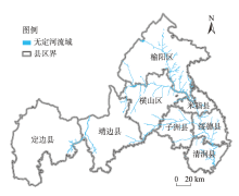
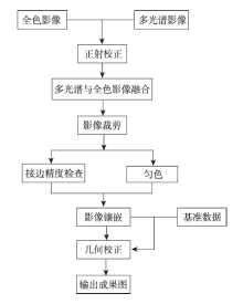
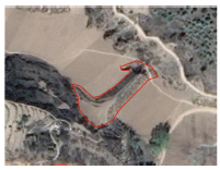
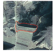
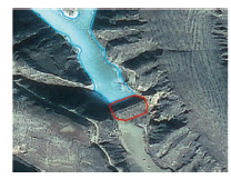
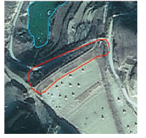
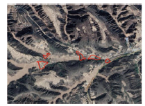
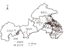
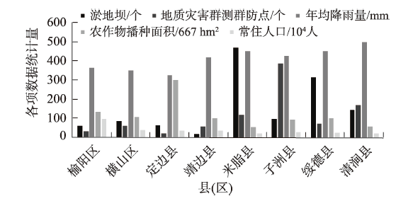
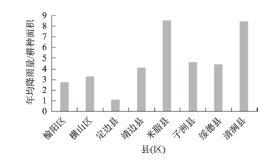
淤地坝是黄土高原水土流失防治的主要措施之一,明确淤地坝的分布、规模等重要参数信息对流域水土保持研究具有重要意义。利用遥感技术(RS)和地理信息系统(GIS)技术,结合陕北地区无定河流域高分二号卫星影像、野外踏勘及资料收集到的研究区淤地坝情况,对其进行预处理获取矢量数据,通过对比分析,得到淤地坝解译标志。针对榆林地区无定河流域淤地坝进行遥感解译,利用遥感及GIS软件实现淤地坝数目、淤地坝位置、水面面积、控制面积等主要信息的提取,获取淤地坝在定边、靖边、米脂、绥德、横山、榆阳、子洲和清涧8个县(区)分布状况。结果显示:研究区共解译出疑似淤地坝图斑1257个,其中榆阳区60个,横山区85个,定边县65个,靖边县19个,米脂县470个,子州县99个,绥德县316个,清涧县143个。由此发现,淤地坝主要分布于无定河下游区域的绥德、米脂、子洲和清涧4县的沟道内,且沟道内多存在耕地或水域。将淤地坝分布情况与地形、年均降雨量、农业种植面积和地质灾害等进行比较分析,显示其分布状况与这些因素相关联,表现为沟壑纵横的区域淤地坝较多,农业种植面积较少的区域淤地坝较多,年均降雨量和耕种面积比值较大区域淤地坝较多。由此,总结其分布规律,为未来淤地坝的维护和修建提供重要支持。

关键词: 淤地坝, 遥感解译, 高分二号卫星, 无定河

Abstract:

This study extracted check dam information using GF-2 data in the Wuding River Basin in the northern Shaanxi Province of China. The cloud cover of every image was less than 5% because the identification of check dams became complicated due to disturbances from shadows. Using remote sensing (RS) and geographic information system (GIS) technology, combined with the GF-2 satellite image of the Wuding River Basin, the situation of the silt dam in the study area collected from field surveys, and data is used to preprocess it to obtain vector data, and through comparison and analysis, we got interpretation sign of silt dam. Remote-sensing interpretation was conducted for the silt dam in the Wuding River Basin in the Yulin area; the main information, such as the number of silt dams, location of the silt dam, water surface area, and control area, were extracted using RS and GIS software. In total, 1257 silt lands were interpreted Batu spots, including 60 in Yuyang District, 85 in Hengshan District, 65 in Dingbian County, 19 in Jingbian County, 470 in Mizhi County, 99 in Zizhou County, 316 in Suide County, and 143 in Qingjian County. Divide an area of more than 1 hectare as large silt dams: 0.5-1.0 hectares as medium silt dams, and less than 0.5 hectares as small silt dams. After the interpretation, 79 were identified as large silt dams (6%); 228 as medium silt dams (18%); and 950 as small silt dams (76%). The results show that the silt dams are distributed in the four counties of Suide, Mizhi, Zizhou, and Qingjian in the lower reaches of the Wuding River, with the number of 1028, accounting for 81.78% and 38.74 hectares, accounting for 73.88%. Large and medium silt dams are distributed in Mizhi County, with the number of 48 and 94, respectively, accounting for 60.76% and 41.23%, respectively. Comparing and analyzing the distribution of silt dams using topography, climate, agriculture, and geological disasters shows that their distribution is related to these factors. Thus, the distribution law is summarized to support the maintenance and construction of silt dams in the future.

Key words: check dam, remote sensing interpretation, GF-2, Wuding River